Lakes and wetlands are significant ecosystems that nourish, sustain, and house many of the planet's plant and animal species. Though both of these regions are defined by water—both fresh and saline—each lake and particular type of wetland also has characteristics all its own. This detailed volume considers the formation, composition, and maintenance of these intricate ecological units and the various life forms they support. Dramatic full-color photographs and in-depth profiles of Earth's major lakes highlight the beauty and complexity of these regions.
- English
- ePUB (mobile friendly)
- Available on iOS & Android
eBook - ePub
Lakes and Wetlands
About this book
Trusted by 375,005 students
Access to over 1.5 million titles for a fair monthly price.
Study more efficiently using our study tools.
Information
Subtopic
EcologyIndex
Biological SciencesCHAPTER 1
LAKES
A lake is a relatively large body of slowly moving or standing water that occupies an inland basin of appreciable size. Definitions that precisely distinguish lakes, ponds, swamps, and even rivers and other bodies of nonoceanic water are not well established. It may be said, however, that rivers and streams are relatively fast moving; marshes and swamps contain relatively large quantities of grasses, trees, or shrubs; and ponds are relatively small in comparison to lakes. Geologically defined, lakes are temporary bodies of water.
Within the global hydrologic cycle, freshwater lakes play a very small quantitative role, constituting only about 0.009 percent of all free water, which amounts to less than 0.4 percent of all continental fresh water. Saline lakes and inland seas contain another 0.0075 percent of all free water. Freshwater lakes, however, contain well over 98 percent of the important surface waters available for use. Apart from that contained in saline bodies, most other continental waters are tied up in glaciers and ice sheets and the remainder is in groundwater.
Four-fifths of the 125,000 cubic km (30,000 cubic miles) of lake waters occur in a small number of lakes, perhaps 40 in all. Among the largest are Lake Baikal, in Central Asia, containing about 23,000 cubic km (5,500 cubic miles) of water; Lake Tanganyika (19,000 cubic km [4,600 cubic miles]), in eastern Africa; and Lake Superior (12,000 cubic km [2,900 cubic miles]), one of the Great Lakes of North America. The Great Lakes contain a total of about 25,000 cubic km (6,000 cubic miles) of water and, together with other North American lakes larger than 10 cubic km (2 cubic miles), constitute about one-fourth of the world’s lake waters. The Caspian Sea, though not considered a lake by some hydrologists, is the world’s largest inland sea. Located in Central Asia, the Caspian Sea has an area of about 386,000 square km (149,000 square miles).
Although lakes are to be found throughout the world, the continents of North America, Africa, and Asia contain about 70 percent of the total lake water, the other continents being less generously endowed. A fourth of the total volume of lake water is spread throughout the world in uncounted numbers of small lakes. Anyone who has flown over much of the Canadian plains area cannot help but be struck by the seemingly endless skein of lakes and ponds covering the landscape below. Though the total volume of water involved is comparatively small, the surface area of lake water is substantial. The total surface area of all Canadian lakes has been estimated to exceed the total surface area of the province of Alberta. The U.S. state of Alaska has more than 3 million lakes with surface areas greater than 8 hectares (20 acres).
The larger, deeper lakes are a significant factor within the cycle of water—from rain to surface water, ice, soil moisture, or groundwater and thence to water vapour. These lakes receive the drainage from vast tracts of land, store it, pass it on seaward, or lose it to the atmosphere by evaporation. On a local basis, even the smaller lakes play an important hydrologic role. The relatively high ratio of exposed surface area to the total water volume of these lakes accentuates their effectiveness as evaporators.
In some cases the efficiency of lakes in losing water to the atmosphere is locally undesirable, because of public and industrial requirements for lake water. A striking example of this condition is the Aral Sea, located in Central Asia. Although it is still one of the world’s largest bodies of inland water, in the second half of the 20th century its area was reduced by two-fifths and its mean surface level had dropped by more than 12 metres (40 feet), as a result primarily of the diversion of the Syr Darya and Amu Darya rivers for irrigating adjoining fields.
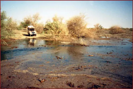
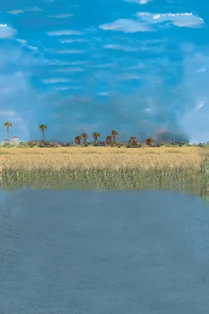
Africa’s Lake Chad, the largest lake in Africa. Chad’s water levels fluctuate with the seasons, since they are dependent upon the vagaries of the hydrologic cycle within a typically arid climate. © Kypros/Alamy
In some basins (e.g., the Chad basin in Africa), lakes are the terrestrial end point of the hydrologic cycle. With no outflow downstream toward the oceans, these closed lakes swell or recede according to the balance of local hydrologic conditions.
LIMNOLOGY: THE STUDY OF FRESH WATERS
Limnology is a subdiscipline of hydrology that deals with the scientific study of fresh waters, specifically those found in lakes and ponds. The discipline also includes the biological, physical, and chemical aspects of the occurrence of lake and pond waters. Limnology traditionally is closely related to hydrobiology, which is concerned with the application of the principles and methods of physics, chemistry, geology, and geography to ecological problems.
THE HISTORY OF LAKES
A newly formed lake generally contains few nutrients and can sustain only a small amount of biomass. It is described as oligotrophic. Natural processes will supply nutrients to a lake in solution in river water and rainwater, in the fallout of dust from the atmosphere, and in association with the sediments washed into the lake. The lake will gradually become eutrophic, with relatively poor water quality and high biological production. Infilling by sediments means that the lake will gradually become shallower and eventually disappear. Natural rates of eutrophication are normally relatively slow. Human activities, however, can greatly accelerate the process by the addition of excessive nutrients in wastewater and the residues of agricultural fertilizers. The result may be excessive biomass production, as evidenced by phytoplankton “blooms” and rapid growth of macrophytes such as Eichhornia.
THE PHYSICAL CHARACTERISTICS OF LAKES
The most important physical characteristic of the majority of lakes is their pattern of temperatures, in particular, the changes of temperature with depth. The vertical profile of temperature may be measured using arrays of temperature probes deployed either from a boat or from a stationary platform. Remote-sensing techniques are being used increasingly to observe patterns of temperature in space and, in particular, to identify the thermal plumes associated with thermal pollution.
In summer the water of many lakes becomes stratified into a warmer upper layer, called the epilimnion, and a cooler lower layer, called the hypolimnion. The stratification plays a major role in the movement of nutrients and dissolved oxygen and has an important control effect on lake ecology. Between the layers there usually exists a zone of very rapid temperature change known as the thermocline. When the lake begins to cool at the end of summer, the cooler surface water tends to sink because it has greater density. Eventually this results in an overturn of the stratification and a mixing of the layers. Temperature change with depth is generally much smaller in winter. Some lakes, called dimictic lakes, can also exhibit a spring overturn following the melting of ice cover, since water has a maximum density at 4 °C (39 °F).
A second important characteristic of lakes is the way that the availability of light changes with depth. Light decreases exponentially (as described by Beer’s law) depending on the turbidity of the water. At the compensation depth the light available for photosynthetic production is just matched by the energy lost in respiration. Above this depth is the euphotic zone, but below it in the aphotic zone phytoplankton—the lowest level in the ecological system of a lake—cannot survive unless the organisms are capable of vertical migration.
Patterns of sediment deposition in lakes depend on the rates of supply in inflowing waters and on subsurface currents and topography. Repetitive sounding of the lake bed may be used to investigate patterns of sedimentation. Remote sensing of the turbidity of the surface waters also has been used to infer rates of sedimentation, as in the artificial Lake Nasser in Egypt. In some parts of the world where erosion rates are high, the operational life of reservoirs may be reduced dramatically by infilling with sediment.
WATER AND ENERGY FLUXES IN LAKES
The water balance of a lake may be evaluated by considering an extended form of the catchment water balance equation outlined above with additional terms for any natural or artificial inflows. An energy balance equation may be defined in a similar way, including terms for the exchange of long-wave and shortwave radiation with the Sun and atmosphere and for the transport of sensible and latent heat associated with convection and evaporation. Heat also is gained and lost with any inflows and discharges from the lake. The energy balance equation controls the thermal regime of the lake and consequently has an important effect on the ecology of the lake.
An important role in controlling the distribution of temperature in a lake is played by currents due either to the action of the wind blowing across the surface of the lake or to the effect of the inflows and outflows, especially where, for example, a lake receives the cooling water from a power-generation plant. In large lakes the effect of the Earth’s rotation has an important effect on the flow of water within the lake. The action of the wind can also result in the formation of waves and, when surface water is blown toward a shore, in an accumulation of water that causes a rise in water level called wind setup. In Lake Erie in North America, increases in water level of more than one metre (3.3 feet) have been observed following severe storms. After a storm the water raised in this way causes a seiche (an oscillatory wave of long period) to travel across the lake and back. Seiches are distinctive features of such long, narrow lakes as Lake Zürich, when the wind blows along the axis of the lake. Internal seiche waves can occur in stratified lakes with layers of different density.
THE WATER QUALITY OF LAKES
The biological health of a lake is crucially dependent on its chemical characteristics. Limnologists and hydrobiologists are attentive to the dissolved oxygen content of the water because it is a primary indicator of water quality. Well-oxygenated water is considered to be of good quality. Low dissolved oxygen content results in anaerobic fermentation, which releases such gases as toxic hydrogen sulfide into the water, with a drastic effect on biological processes.
Another major concern of limnologists and hydrobiologists is the cycling of basic nutrients within a lake system, particularly carbon, nitrogen, phosphorus, and sulfate. An excess of the latter in runoff waters entering a lake may result in high concentrations of hydrogen ions in the water. Such acid (low values of pH) waters are harmful to the lake biology. In particular, aluminium compounds are soluble in water at low pH and may cause fish to die because of the response induced in their gills.
LAKE BASINS
In addition to the water in lakes and ponds, limnologists also concern themselves with the study of the basins in which the water is held. Lake basins are classified by the forces and processes involved in their creation. The topography and the processes that drive sedimentation in lake basins are also important topics of study since they affect the behaviour of lake waters and provide significant insight into how lakes evolve over time.
THE CLASSIFICATION OF BASINS
Limnologists have used several criteria for the development of systems for classifying lakes and lake basins but have resorted particularly to the mechanisms that have produced lake basins. These have been summarized and examined in A Treatise on Limnology, by the American limnologist G.E. Hutchinson, which includes treatment of tectonism, volcanism, landslides, glaciation, solution, river action, wind action, coastline building, organic accumulation, animal activity, meteoritic impact, and human activity.
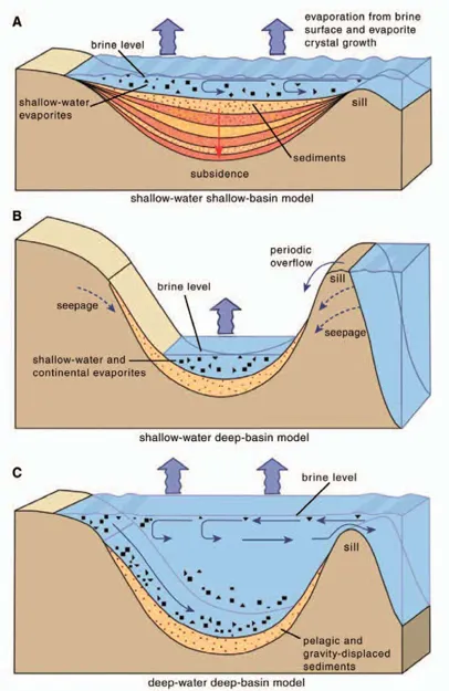
Three models for deposition of marine evaporites in basins of restricted water circulation. Copyright Encyclopædia Britannica; rendering for this edition by Rosen Educational Services.
Evaporites are any of a variety of individual minerals found in the sedimentary deposit of soluble salts that results from the evaporation of water.
Typically, evaporite deposits occur in closed marine basins where evaporation exceeds inflow. The deposits often show a repeated sequence of minerals, indicating cyclic conditions with a mineralogy determined by solubility. The most important minerals and the sequence in which they form include calcite, gypsum, anhydrite, halite, polyhalite, and lastly potassium and magnesium salts such as sylvite, carnallite, kainite, and kieserite; anhydrite and halite dominate. These sequences have been reproduced in laboratory experiments and, therefore, the physical and chemical conditions for evaporite formation are well known.
In contrast to basin deposits, extensive thin-shelf deposits are known and are thought to be the result of shallow, ephemeral seas. Non-marine evaporites formed by streams flowing into closed depressions, especially in arid regions, give rise to deposits of borates, nitrates, and sodium carbonates. Such deposits occur in Utah and southern California in the United States.
BASINS FORMED BY TECTONISM, VOLCANISM, AND LANDSLIDES
Tectonism—or movement of the Earth’s crust—has been responsible for the formation of very large basins. Late in the Miocene Epoch (about 23 to 5.3 million years ago), broad, gentle earth movements resulted in the isolation of a vast inland sea across southern Asia and southeastern Europe. Through the Paleogene and Neogene periods (from about 65.5 million to 2.6 million years ago), sub-basins developed that gradually were characterized by a great range of salinities. Resumption of communication with the oceans occurred later, and there is evidence of considerable variation in water levels. The present remnants of these inland bodies of water include the Caspian Sea and the Aral Sea, along with numerous smaller lakes. The Black Sea, which was also once part of this large inland basin, is now in direct communication with the oceans.
In some cases, elevated land areas may already contain depressions that eventually form lake basins. Lake Okeechobee, Florida, is cited as being such a basin, formed by uplift of the ocean floor.
Tectonic uplift may interfere with natural land-drainage patterns in such a way as to produce lake basins. The Great Basin of South Australia, some of the lakes in Central Africa (e.g., Lakes Kioga and Kwania), and to some extent Lake Champlain, in the northeastern United States, are examples of this mechanism. Land subsidence, due to earthquake activity, also has resulted in the development of depressions in which lakes have evolved. Many such cases have been reported within the past 300 years.
The damming of valleys as a result of various tectonic phenomena has resulted in the formation of a few lake basins, but faulting, in its great variety of forms, has been responsible for the formation of many important lake basins. Abert Lake, in Oregon, lies in the depression formed by a tilted fault block against the higher block. Indeed, many lakes in the western United States are located in depressions formed through faulting, including Lake Tahoe, in the Sierra Nevada, California. Great Salt Lake, Utah, and other nearby salt lakes are remnants of Lake Bonneville, a large lake of Pleistocene age (i.e., about 11,700 to 2,600,000 years old) which was formed at least partly by faulting activity.
In other parts of the world, faulting has also played an important role in basin formation. Lake Baikal and Lake Tanganyika, the two deepest lakes in the world, occupy basins formed by complexes of grabens (downdropped faulted blocks). These lakes are among the oldest of modern lakes, as are other graben lakes, particularly those within the East African rift system, which extends through the East African lake system and includes the Red Sea.
Basins formed from volcanic activity are also greatly varied in type. The emanation of volcanic material from beneath the surface can be explosive, or it can issue in a gentle and regular manner. This range of activity and the variation of types of material which may be involved produce many different types of basins.
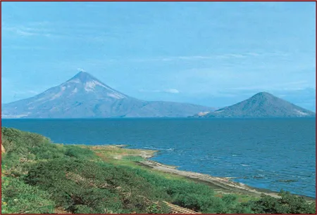
Momotombo Volcano (left) and Momotombito Island, viewed across Lake Managua, Nicaragua. Byron Augustin/D. Donne Bryant Stock
One broad category includes those occupying the actual volcanic craters or their remnants. Crater lakes may occupy completely unmodified cinder cones, but these are rare. Craters caused by explosions or by the collapse of the roofs of underground magma (molten silica) chambers and those caused by explosion of new volcanic sources and that are built of nonvolcanic material are other examples. The latter are termed maars, following the local name for such forms in Germany. They are found, however, in several locations, including Iceland, Italy, and New Zealand. The maars of the volcanic district of Eifel, Western Germany, are among the best known of these formations.
The collapse of magma chambers and the development of very large surface craters called calderas is an important source of lake basins. Crater Lake, Oregon, is a typical example, exhibiting characteristically great depth and a high encircling rim. Some caldera basins evolved with gently sloping sides, however, due to the deposition of material from a series of explosions and a gentler collapse of the structure. Secondary cones may develop within calderas, as shown by...
Table of contents
- Cover Page
- Title Page
- Copyright Page
- Contents
- Introduction
- Chapter 1: Lakes
- Chapter 2: Lake Hydraulics
- Chapter 3: Inland Water Ecosystems
- Chapter 4: Major Lakes of the World
- Chapter 5: Wetlands
- Chapter 6: Wetland Flora and Fauna
- Appendix A: Notable Smaller Lakes of the World
- Appendix B: Average Net Primary Production of the Earth’s Major Habitats
- Appendix C: Areas and Volumes of the Great Lakes
- Glossary
- Bibliography
- Index
Frequently asked questions
Yes, you can cancel anytime from the Subscription tab in your account settings on the Perlego website. Your subscription will stay active until the end of your current billing period. Learn how to cancel your subscription
No, books cannot be downloaded as external files, such as PDFs, for use outside of Perlego. However, you can download books within the Perlego app for offline reading on mobile or tablet. Learn how to download books offline
Perlego offers two plans: Essential and Complete
- Essential is ideal for learners and professionals who enjoy exploring a wide range of subjects. Access the Essential Library with 800,000+ trusted titles and best-sellers across business, personal growth, and the humanities. Includes unlimited reading time and Standard Read Aloud voice.
- Complete: Perfect for advanced learners and researchers needing full, unrestricted access. Unlock 1.5M+ books across hundreds of subjects, including academic and specialized titles. The Complete Plan also includes advanced features like Premium Read Aloud and Research Assistant.
We are an online textbook subscription service, where you can get access to an entire online library for less than the price of a single book per month. With over 1.5 million books across 990+ topics, we’ve got you covered! Learn about our mission
Look out for the read-aloud symbol on your next book to see if you can listen to it. The read-aloud tool reads text aloud for you, highlighting the text as it is being read. You can pause it, speed it up and slow it down. Learn more about Read Aloud
Yes! You can use the Perlego app on both iOS and Android devices to read anytime, anywhere — even offline. Perfect for commutes or when you’re on the go.
Please note we cannot support devices running on iOS 13 and Android 7 or earlier. Learn more about using the app
Please note we cannot support devices running on iOS 13 and Android 7 or earlier. Learn more about using the app
Yes, you can access Lakes and Wetlands by Britannica Educational Publishing, John P Rafferty in PDF and/or ePUB format, as well as other popular books in Biological Sciences & Ecology. We have over 1.5 million books available in our catalogue for you to explore.