The devastation wrought by earthquakes and volcanoes often obscures the fact that these destructive forces are also some of the most creative on the planet birthing mountains and other land forms. With detailed diagrams outlining the structure of continental and oceanic crust and the distribution of major plate motion, this book introduces readers to the range of activity that can shape or decimate an entire region. Descriptions of famous earthquakes and volcanoes help contextualize the staggering power of the Earth's motion.
eBook - ePub
Plate Tectonics, Volcanoes, and Earthquakes
- English
- ePUB (mobile friendly)
- Available on iOS & Android
eBook - ePub
Plate Tectonics, Volcanoes, and Earthquakes
About this book
Trusted by 375,005 students
Access to over 1.5 million titles for a fair monthly price.
Study more efficiently using our study tools.
Information
Topic
Physical SciencesSubtopic
Geology & Earth SciencesCHAPTER 1
EARTH’S DYNAMIC INTERIOR
Earth is a restless planet. The most easily observed evidence of this fact is revealed in the continuous movement of air and water. One should keep in mind, however, that the ground itself is also moving, albeit much more slowly. The hard crust of Earth’s surface sits upon the weak, plastic rocks of the asthenosphere, and magma (molten or partially molten underground rock) continually rises from Earth’s mantle toward the surface. These two factors cause continents to move and oceans to change shape; however, these changes are often imperceptible to the human eye. Occasionally, the ground moves suddenly and violently, when one section of the crust slides against another or when rising magma is delivered to Earth’s surface or expelled into the atmosphere; such violent movements manifest themselves as earthquakes and volcanoes, respectively. This book considers the internal forces that act to change Earth’s surface.
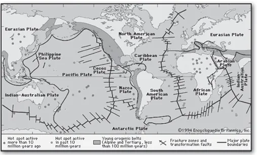
The principal tectonic plates that make up Earth’s lithosphere. Also located are orogenic belts, or great mountain ranges, that have been produced comparatively recently at the boundaries of converging plates. The several dozen hot spots locate sites where plumes of hot mantle material are upwelling beneath the plates. Encyclopædia Britannica, Inc.
THE PROCESS OF PLATE TECTONICS
Plate tectonics is a theory dealing with the dynamics of Earth’s outer shell, the lithosphere, that revolutionized earth sciences by providing a uniform context for understanding mountain-building processes, volcanoes, and earthquakes, as well as understanding the evolution of Earth’s surface and reconstructing its past continental and oceanic configurations.
The concept of plate tectonics was formulated in the 1960s. According to the theory, Earth has a rigid outer layer, known as the lithosphere, which is about 100 km (60 miles) thick and overlies a plastic layer called the asthenosphere. The lithosphere is broken up into about a dozen large plates and several small ones. These plates move relative to each other, typically at rates of 5 to 10 cm (2 to 4 inches) per year, and interact at their boundaries, where they either converge, diverge, or slip past one another. Such interactions are thought to be responsible for most of Earth’s seismic and volcanic activity, although earthquakes and volcanoes are not wholly absent in plate interiors. Plate motions cause mountains to rise where they push together or continents to fracture and oceans to form where they pull apart. The continents are embedded in the plates and drift passively with them, which over millions of years results in significant changes in Earth’s geography.
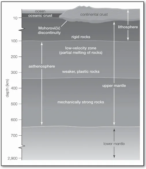
A cross section of Earth’s outer layers, from the crust through the lower mantle. Encyclopædia Britannica, Inc.
The theory of plate tectonics is based on a broad synthesis of geologic and geophysical data. It is now almost universally accepted, and its adoption represents a true scientific revolution, analogous in its consequences to the Rutherford and Bohr atomic models in physics or the discovery of the genetic code in biology. Incorporating the much older idea of continental drift, the theory of plate tectonics has provided an overarching framework in which to describe the past geography of continents and oceans, processes controlling the creation and destruction of landforms, and the evolution of Earth’s crust, atmosphere, biosphere, ancient oceans, and climates.
PRINCIPLES OF PLATE TECTONICS
In essence, plate tectonic theory is elegantly simple. Earth’s surface layer, from 50 to 100 km (30 to 60 miles) thick, is rigid and is composed of a set of large and small plates. Together these plates constitute the lithosphere, from the Greek lithos, meaning “rock.” The lithosphere rests on and slides over an underlying, weaker layer of plastic and partially molten rock known as the asthenosphere, from the Greek asthenos, meaning “weak.” Plate movement is possible because the lithosphere-asthenosphere boundary is a zone of detachment. As the lithospheric plates move across Earth’s surface, driven by forces as yet not fully understood, they interact along their boundaries, diverging, converging, or slipping past each other. While the interiors of the plates are presumed to remain essentially undeformed, plate boundaries are the sites of many of the principal processes that shape the terrestrial surface, including earthquakes, volcanism, and orogeny (that is, formation of mountain ranges).
CONTINENTAL AND OCEANIC CRUST
The lithosphere is subdivided on the basis of the presence of rock types with different chemical compositions. The outermost layer of the lithosphere is called the crust, of which there are two types, continental and oceanic, which differ in their composition and thickness. The distribution of these crustal types closely coincides with the division into continents and ocean basins. The continents have a crust that is broadly granitic in composition and, with a density of about 2.7 grams per cubic cm (0.098 pound per cubic inch), is somewhat lighter than oceanic crust, which is basaltic in composition and has a density of about 2.9 to 3 grams per cubic cm (0.1 to 0.11 pound per cubic inch). Continental crust is typically 40 km (25 miles) thick, while oceanic crust measures only 6 to 7 km (3.7 to 4.4 miles) in thickness.
These crustal rocks both sit on top of the mantle, which is ultramafic in composition (that is, rich in iron-and magnesium-bearing minerals). The boundary between the continental or oceanic crust and the underlying mantle, named the Mohorovičic´ discontinuity (also called Moho) for Andrija Mohorovičic´, Croatian seismologist and its discoverer, has been clearly defined by seismic studies. The mantle is Earth’s most voluminous layer, extending to a depth of 2,900 km (1,800 miles). However, increasing temperatures with depth cause mantle rocks to lose their rigidity at about 100 km (60 miles) below the surface. This change in rheology (a science examining the flow and deformation of materials) defines the base of the lithosphere and the top of the asthenosphere. This upper portion of the mantle, known as the lithospheric mantle, has an average density of about 3.3 grams per cubic cm (0.12 pound per cubic inch).
The effect of the different densities of lithospheric rock can be seen in the different average elevations of continental and oceanic crust. The less-dense continental crust has greater buoyancy, causing it to float much higher in the mantle. Its average elevation above sea level is 840 metres (2,750 feet), while the average depth of oceanic crust is 3,790 metres (12,400 feet). This density difference creates two principal levels of Earth’s surface.
PLATE BOUNDARIES
Lithospheric plates are much thicker than oceanic or continental crust. Their boundaries do not usually coincide with those between oceans and continents, and their behaviour is only partly influenced by whether they carry oceans, continents, or both. The Pacific Plate, for example, is purely oceanic, whereas the North American Plate is capped by continental crust in the west (the North American continent) and by oceanic crust in the east—it extends under the Atlantic Ocean as far as the Mid-Atlantic Ridge.
Divergent Margins
As plates move apart at a divergent plate boundary, the release of pressure produces partial melting of the underlying mantle. This molten material, known as magma, is basaltic in composition and is buoyant. As a result, it wells up from below and cools close to the surface to generate new crust. Because new crust is formed, divergent margins are also called constructive margins.
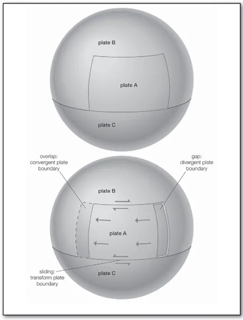
Theoretical diagram showing the effects of an advancing tectonic plate on other adjacent, but stationary, tectonic plates. At the advancing edge of plate A, the overlap with plate B creates a convergent boundary. In contrast, the gap left behind the trailing edge of plate A forms a divergent boundary with plate B. As plate A slides past portions of both plate B and plate C, transform boundaries develop. Encyclopædia Britannica, Inc.
Continental Rifting
Upwelling of magma causes the overlying lithosphere to uplift and stretch. If the diverging plates are capped by continental crust, fractures develop that are invaded by the ascending magma, prying the continents farther apart. Settling of the continental blocks creates a rift valley, such as the present-day East African Rift Valley. As the rift continues to widen, the continental crust becomes progressively thinner until separation of the plates is achieved and a new ocean is created. The ascending partial melt cools and crystallizes to form new crust. Because the partial melt is basaltic in composition, the new crust is oceanic. Consequently, diverging plate boundaries, even if they originate within continents, eventually come to lie in ocean basins of their own making.
Seafloor Spreading
As upwelling of magma continues, the plates continue to diverge, a process known as seafloor spreading. Samples collected from the ocean floor show that the age of oceanic crust increases with distance from the spreading centre—important evidence in favour of this process. These age data also allow the rate of seafloor spreading to be determined, and they show that rates vary from about 0.1 cm (0.04 inch) per year to 17 cm (6.7 inches) per year. Seafloor spreading rates in the Pacific Ocean are much more rapid than in the Atlantic or Indian oceans. At spreading rates of about 15 cm (6 inches) per year, the entire crust beneath the Pacific Ocean (about 15,000 km, or 9,300 miles, wide) could be produced in 100 million years.
Divergence and creation of oceanic crust are accompanied by much volcanic activity and by many shallow earthquakes as the crust repeatedly rifts, heals, and rifts again. These regions are swollen with heat and so are elevated by 2 to 3 km (1.2 to 1.9 miles) above the surrounding seafloor. Their summits are typically 1 to 5 km (0.6 to 3.1 miles) below the ocean surface. On a global scale, these features form an interconnected system of undersea mountains about 65,000 km (40,000 miles) in length and are called oceanic ridges.
Oceanic crust, once formed, cools as it ages and eventually becomes denser than the underlying asthenosphere, and so it has a tendency to subduct. The life span of this crust is prolonged by its rigidity, but eventually this resistance is overcome. The geologic record suggests that subduction commences when oceanic crust is about 200 million years old.
Convergent Margins
Given that Earth is constant in volume, the continuous formation of new crust produces an excess that must be balanced by destruction of crust elsewhere. This is accomplished at convergent plate boundaries, also known as destructive plate boundaries, where one plate descends at an angle—that is, is subducted—beneath the other. Where two oceanic plates meet, the older, denser plate is preferentially subducted beneath the younger, warmer one. Where one of the plate margins is oceanic and the other is continental, the greater buoyancy of continental crust prevents it from sinking, and the oceanic plate is preferentially subducted. Continents are preferentially preserved in this manner relative to oceanic crust, which is continuously recycled into the mantle; this explains why ocean floor rocks are generally less than 200 million years old whereas the oldest continental rocks are almost 4 billion years old. Where two plates carrying continental crust collide, neither is subducted. Instead, towering mountain ranges, such as the Himalayas, are created.
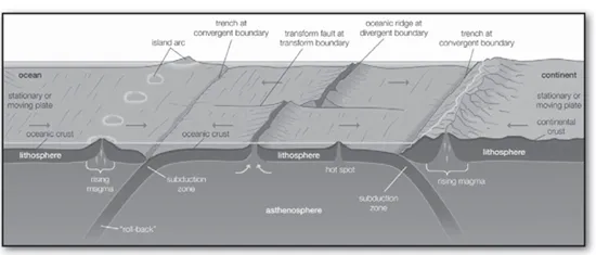
Three-dimensional diagram showing crustal generation and destruction according to the theory of plate tectonics; included are the three kinds of plate boundaries—divergent, convergent (or collision), and strike-slip (or transform). Encyclopædia Britannica, Inc.
Because the plates form an integrated system, it is not necessary that new crust formed at any given divergent boundary be completely compensated at the nearest subduction zone, as long as the total amount of crust generated equals that destroyed.
Subduction Zone Trenches
The subduction process involves the descent into the mantle of a slab of cold, hydrated oceanic lithosphere about 100 km (60 miles) thick that carries a relatively thin cap of oceanic sediments. The path of descent is defined by numerous earthquakes along a plane that is typically inclined between 30° and 60° into the mantle and is called the Benioff zone, for American seismologist Hugo Benioff, who pioneered its study. Most, but not all, earthquakes in this planar dipping zone result from compression, and the seismic activity extends 300 to 700 km (185 to 435 miles) below the surface. At greater depths, the subducted plate melts and is recycled into the mantle.
The site of subduction is marked by a deep trench between 5 and 11 km (3 and 7 miles) deep that is produced by frictional drag between the plates as the descending plate bends before it subducts. The overriding plate scrapes sediments and elevated portions of ocean floor off the upper crust of the lower plate, creating a zone of highly deformed rocks within the trench that becomes attached, or accreted, to the overriding plate. This chaotic mixture is known as an accretionary wedge.
The rocks in the subduction zone experience high pressures but relatively low temperatures, an effect of the descent of the cold oceanic slab. Under these conditions the rocks recrystallize, or metamorphose, to form a suite of rocks known as blueschists, named for the diagnostic blue mineral glaucophane, which is stable only at the high pressures and low temperatures found in subduction zones.
Island Arcs
When the downgoing slab reaches a depth of about 100 km (60 miles), it gets sufficiently warm to drive off its most volatile components, thereby stimulating partial melting of mantle in the plate above the subduction zone (known as the mantle wedge). Melting in the mantle wedge produces magma, which is predominantly basaltic in composition. This magma rises to the surface and gives birth to a line of volcanoes in the overriding plate, known as a volcanic arc, typically a few hundred kilometres behind the oceanic trench. The distance between the trench and the arc, known as the arc-trench gap, depends on the angle of subduction. Steeper subduction zones have relatively narrow arc-trench gaps. A basin may form within this region, known as a forearc basin, and may be filled with sediments derived from the volcanic arc or with remains of oceanic crust.
If both plates are oceanic, such as in the modern western Pacific Ocean, the volcanoes form a curved line of islands, known as an island arc, that is parallel to the trench. If one plate is continental, the volcanoes form inland, as they do in the Andes of western South America. Though the process of magma generation is similar, the ascending magma may change its composition as it rises through the thick lid of continental crust, or it may provide sufficient heat to melt the crust. In either case, the composition of the volcanic mountains formed tends to be more silicon-rich and iron- and magnesium-poor relative to the volcanic rocks produced by ocean-ocean convergence.
Back-Arc Basins
Where both converging plates are oceanic, the margin of the older oceanic crust will be subducted because older oceanic crust is colder and therefore more dense. As the dense slab collapses into the asthenosphere, however, it also may “roll back” oceanward and cause extension in the overlying plate. This results in a process known as back-arc spreading, in which a basin opens up behind the island arc. This style of subduction predominates in the western Pacific Ocean, in which a back-arc basin separates several island arcs from the Asian continent.
Continental Collision
If the rate of subduction in an ocean basin exceeds the rate at which the crust is formed at oceanic ridges, closure of the basin is inevitable, leading ultimately to terminal collision between the approaching continents. For example, the subduction of the Tethys Sea, a wedge-shaped body of water that was located between Gondwana and Laurasia, led to the accretion of terranes (crustal blocks or formations of related rocks) along the margins of Laurasia. These events were followed by continental collisions beginning about 30 million years ago between Africa and Europe and between India and Asia. These collisions culminated in the formation of the Alps and the Himalayas. Because continental lithosphere is too buoyant to be subducted, one continent overrides the other, producing crustal thickening and intense deformation that forces the crust skyward to form huge mountains.
Accretion and Obduction
As subduction leads to contraction of an ocean, elevated regions within the ocean basin such as linear island chains, oceanic ridges, and small crustal fragments (such as Madagascar or Japan), known as terranes, are transported toward the subduction zone, where they are scraped off the descending plate and added—accreted—to the continental margin. Since the Late Devonian and Early Carboniferous periods, some 360 million years ago, subduction beneath the western margin of North America has resulted in several collisions with terranes, each producing a mountain-building event. The piecemeal addition of these accreted terranes has added an average of 600 km (375 miles) in width along the western margin of the North American continent.
During these accretionary events, small sections of the oceanic crust may break away from the subducting slab as it descends. Instead of being subducted, these slices are thrust over the overriding plate and are said to be obducted. Where this occurs, rare slices of ocean crust, known as ophiolites, are preserved on land. They provide a valuable natural laboratory for studying the composition and character of the oceanic crust and the mechanisms of their empla...
Table of contents
- Cover Page
- Title Page
- Copyright Page
- Contents
- Introduction
- Chapter 1: Earth’s Dynamic Interior
- Chapter 2: Volcanoes and Volcanism
- Chapter 3: Earthquakes
- Glossary
- For Further Reading
- Index
Frequently asked questions
Yes, you can cancel anytime from the Subscription tab in your account settings on the Perlego website. Your subscription will stay active until the end of your current billing period. Learn how to cancel your subscription
No, books cannot be downloaded as external files, such as PDFs, for use outside of Perlego. However, you can download books within the Perlego app for offline reading on mobile or tablet. Learn how to download books offline
Perlego offers two plans: Essential and Complete
- Essential is ideal for learners and professionals who enjoy exploring a wide range of subjects. Access the Essential Library with 800,000+ trusted titles and best-sellers across business, personal growth, and the humanities. Includes unlimited reading time and Standard Read Aloud voice.
- Complete: Perfect for advanced learners and researchers needing full, unrestricted access. Unlock 1.5M+ books across hundreds of subjects, including academic and specialized titles. The Complete Plan also includes advanced features like Premium Read Aloud and Research Assistant.
We are an online textbook subscription service, where you can get access to an entire online library for less than the price of a single book per month. With over 1.5 million books across 990+ topics, we’ve got you covered! Learn about our mission
Look out for the read-aloud symbol on your next book to see if you can listen to it. The read-aloud tool reads text aloud for you, highlighting the text as it is being read. You can pause it, speed it up and slow it down. Learn more about Read Aloud
Yes! You can use the Perlego app on both iOS and Android devices to read anytime, anywhere — even offline. Perfect for commutes or when you’re on the go.
Please note we cannot support devices running on iOS 13 and Android 7 or earlier. Learn more about using the app
Please note we cannot support devices running on iOS 13 and Android 7 or earlier. Learn more about using the app
Yes, you can access Plate Tectonics, Volcanoes, and Earthquakes by Britannica Educational Publishing, John P Rafferty in PDF and/or ePUB format, as well as other popular books in Physical Sciences & Geology & Earth Sciences. We have over 1.5 million books available in our catalogue for you to explore.