The Gulf War inflicted dramatic environmental damage upon the fragile desert and shore environments of Kuwait and north eastern Saudi Arabia. Marine environments experienced oil spills; inland, oil lakes and burning oil wells caused widespread pollution. This book, first published in 1994, presents an in-depth analysis of these environmental disasters, their long-term consequences, and potential ways to repair the damage.
- 224 pages
- English
- ePUB (mobile friendly)
- Available on iOS & Android
eBook - ePub
The Gulf War and the Environment
About this book
Trusted by 375,005 students
Access to over 1.5 million titles for a fair monthly price.
Study more efficiently using our study tools.
Information
Detection by Satellite Images of Environmental Change Due to the Gulf War
FAROUK EL-BAZ, A. ABUELGASIM, M. KOCH, M. PAX-LENNEY, E. LAMBIN, A. AL-DOASARI, P. MARR, S. RYHERD, and R. MORENCY
Center for Remote Sensing Boston University, Boston MA 02215
The invasion of Kuwait on 2 August 1990, the subsequent occupation by Iraqi military forces, and the war of liberation that followed, have affected the environment of the northern part of the Arabian Gulf region. Environmental impacts on the atmosphere from the burning of Kuwait's oil wells, on the Gulf water from major oil spills, and on the land surface from disturbances of the desert pavement are clearly depicted on satellite images. Photographs by Meteosat, NOAA 10 and 11 satellites and the Space Shuttle astronauts and particularly images by the Landsat Thematic Mapper and SPOT show the utility of numerous images from various space platforms. Change detection techniques are very useful in recognizing environmental change through the comparison of pre-war and post-war images. Furthermore, Geographic Information System (GIS) methodologies allow production of thematic maps to distinguish change and interpret its causes.
I. Introduction
Iraq invaded Kuwait on 2 August 1990, During the eight months that followed, war preparations and the military conflict that ensued resulted in much degradation to the environment of the region. Environmental impacts resulted in much degradation to the environment of the region including the burning of Kuwait's oil wells, spilling of oil in the Arabian (Persian) Gulf water, and disturbing the desert surface by military activities. The latter was only recently recognized as a war-related environmental impact based on observations in the Sinai Desert of Egypt (Holden, 1991).
Severe environmental damage and disruption of operations in Kuwait's oil fields (Figure 1) resulted from the explosion of 732 wells by Iraqi troops before they left Kuwait. Efforts by teams of fire fighters succeeded in capping the last well fire on 8 November 1991 (Sipa, 1992, p. 162). This ended the dark plume of oil droplets, soot and smoke that emanated from the well fires, and ceased the "oil rain" that blackened vast stretches of the desert and polluted coastal areas of the Gulf. The predominance of oil droplets in the "smoke plume" from the well fires was first noted by El-Baz (1992a and b) after a visit to the region on 23 April-3 May 1991 (Table 1).
As the well fires were put out, much oil seeped from the well-heads and formed stagnant pools. Furthermore, some of the wells exploded by Iraqi troops did not catch fire and continued to spew oil onto the land creating oil patches, streams and vast lakes (El-Baz, 1992c). These lakes hamper operations in the oil fields and constitute a health hazard to humans, animals and plants. Furthermore, roadbeds that had to be built to reach the oil wells during firefighting operations cause further hazards as they are affected by wind erosion and sand deposition. All of these features are clearly depicted in satellite images of Kuwait and neighboring regions.
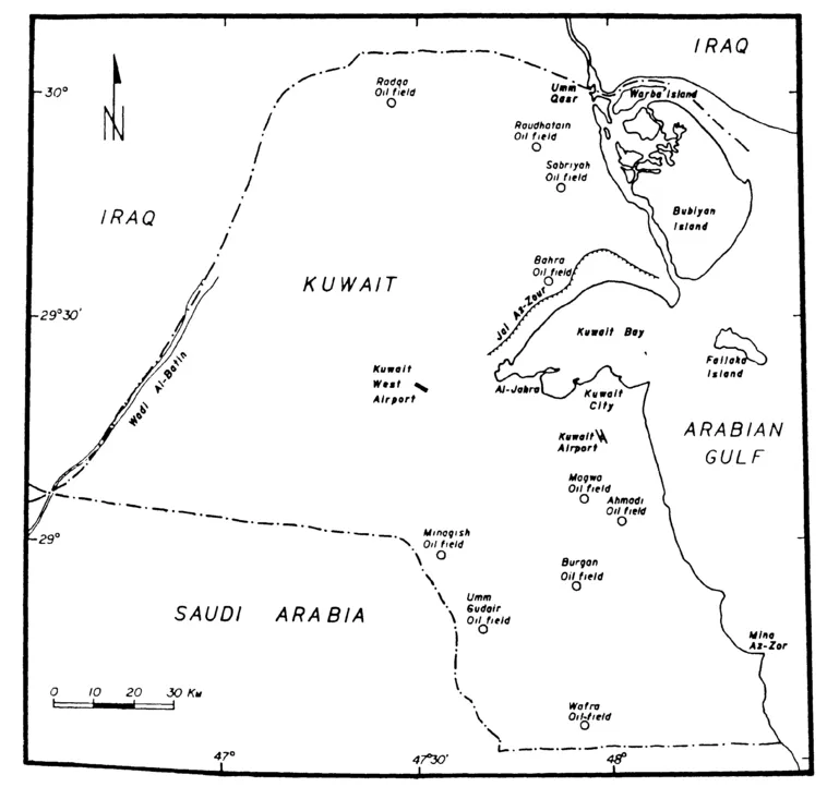
Figure 1. Map of Kuwait showing its major geographic features and the location of ten oil fields.
II. Satellite Images
As the introduction of aircraft, early in this century, has revolutionized the map-making process by providing photogrammetric quality aerial photographs, space age technology has made another giant leap by providing similar photographs from space. During the past 25 years, much has been learned about photographing the Earth from space. The American Gemini, Apollo, Skylab, Apollo-Soyuz, and Space Shuttle missions returned various photographs of the Earth utilizing numerous instruments (El-Baz, 1984). In addition, the Landsat program introduced in 1972 digital imaging from space, where image data were transmitted to ground receiving stations. The technology of these systems provides an ad
Table 1. Chronology of the Gulf Conflict and Post-War Activities. (Modified from Williams et al., 1991)
| 2 August 1990 | Iraq invades Kuwait |
| Late October-early November 1990 | Iraqi forces change offensive posture to defensive fortifications; digging in the land surface of Kuwait begins in earnest |
| 16 January 1991 | Allied forces declare war and begin aerial bombardment of Iraq |
| 19–23 January 1991 | Iraq releases oil from Sea Island terminal into the Gulf |
| 22 January 1991 | Iraq initiates the burning of oil wells, starting with the Wafra field and moving northward |
| 26 January 1991 | Allied bombing ends oil flow from terminal; oil visible in gulf on NOAA AVHRR image |
| 8 February 1991 | Oil visible in Gulf on Landsat TM image |
| 9 February 1991 | Smoke plumes from oil well fires visible on SPOT image |
| 15 February 1991 | Smoke plumes visible on Landsat TM image |
| 21 February 1991 | Smoke plumes visible on NOAA AVHRR image |
| 24 February 1991 | Allied ground offensive begins; extensive smoke plumes visible in Landsat TM, Meteosat, and NOAA AVHRR image |
| 2 March 1991 | Smoke plumes visible on SPOT images |
| 3 March 1991 | Conclusion of ground campaign; smoke plumes, oil slick visible on Landsat TM image |
| 8 March 1991 | Smoke plumes visible on Meteosat image |
| 16 March –4April 1991 | United Nations sends mission to assess loss of life in Kuwait; the mission also assessed damage to Kuwait’s infrastructure (UN, 1991) |
| 23–31 March 1991 | UK Meteorological Office aircraft flights to study smoke plumes in the atmosphere of Kuwait and environs |
| 5–11 April 1991 | Space Shuttle mission STS-37 photographs plumes and oil slick |
| 10 April 1991 | Smoke plumes visible on NOAA AVHRR image |
| 23 April–3 May 1991 | Mission of Third World Academy of Sciences to the Gulf region |
| 28 April–6 May 1991 | Space Shuttle mission STS-39 photographs plumes and oil slick |
| 16 May–15 June 1991 | University of Washington aircraft flights to study smoke plumes |
| 18 May 1991 | Goethe University aircraft flights to study smoke plumes |
| 19 May–4 June 1991 | NCAR aircraft flights to study plumes |
| May–June 1992 | NOAA sends the Mount Mitchell to study Gulf water and biota |
vanced new tool for the acquisition of data that are necessary for monitoring environmental change on the surface of the Earth.
In the acquisition of data necessary for the study of environmental change, unmanned and manned spacecraft systems are planned to fly in high, medium, or low orbits. The highest orbits are left to the unmanned weather satellites, such as Meteosat. These are propelled to a height of 36,000 kilometers above the Earth. At this altitude, their motion is equivalent in speed to the rotation of the Earth about its own axis. Such satellites are termed geostationary, and remain above the same point on the Earth to acquire and transmit repetitive images as frequently as hourly. Due to their high altitude, the images they collect can cover most of one hemisphere of the Earth at low spatial resolution, which is ideal for studying global weather phenomena.
The intermediate orbits are those from 500 to 2000 kilometers above the Earth, the region where most unmanned imaging satellites are placed. For example, the polar-orbiting satellites of the National Oceanic and Atmospheric Administration (NOAA) fly at altitudes of 835 to 870 km; and the near-polar orbits of the American Landsat and the French Systeme Pour l'Observation de la Terre (SPOT) reach a maximum altitude of 920 km above the Earth. Images collected from those altitudes provide greater local detail than is possible from the high-altitude satellites, but the area covered by individual images is significantly reduced. One result of this is that these satellites provide less frequent coverage than weather satellites (16 days for Landsat, and 28 days for SPOT).
On the lower end, most manned missions are placed in orbits below 500 km, to a minimum of 150 kilometers above the Earth. For example, the Space Shuttle operational altitude is about 300 kilometers. From this altitude, images show great detail such as those of the Large Format Camera (LFC: Doyle, 1985; and El-Baz, 1985).
Images obtained from most of these satellite systems have been utilized in the present study of the disruption of the oil fields of Kuwait. For this reason, a description of the applicable systems is given below with emphasis on the data that pertain to the war's environmental impact; satellite images of the Gulf region obtained through June 1991 are listed by Williams et al. (1991).
1. Meteosat
Meteosat is a series of geostationary meteorological satellites launched by the European Space Agency (ESA); the first began operation in 1977. Two satellites are currently operating: Meteosat 3 is positioned at the Equator and 50 degrees west, above South America; and Meteosat 4 is positioned at the Equator and 0 degrees. Because the latter is positioned near the prime meridian, above West Africa, the satellite's view of the Gulf is oblique, since it is located far from the nadir (Figure 2).
The spin-stabilized, geostationary Meteosat spacecraft carry: (1) a visible-IR radiometer to provide high-quality day images and day and night temperature data; (2) a communication package to disseminate image data to user stations; and (3) a communication package to collect data from various Earth-based platforms. The radiometer acquires data in the visible, near-infrared, and thermal-infrared wavelengths. The two infrared images consist of 2500 lines of 2500 picture elements (pixels); the visible image has 5000 lines of 5000 pixels. The spatial resolution at the subsateliite point is 5 km for the infrared channels and 2.5 km for the visible band (Mason, 1987).
2. NOAA Satellites
The National Oceanic and Atmospheric Administration (NOAA) has two polar-orbiting Environmental Satellites. These are NQAA-10, which was launched in September 1986, and acquires data over the Gulf at approximately 7:30 am and 7:30 pm daily;and NOAA-11, which was launched in September 1988, and acquires data over the Gulf at approximately 1:40 am and 1:40 pm daily.
Primary sensors on the NOAA satellites include: an Advanced Very High Resolution Radiometer (AVHRR); TIROS Operational Vertical Sounder (TOVS); Earth Radiation Budget Experiment (ERBE); and a Solar Backscatter Ultraviolet Spectrometer (SBUV/2). Secondary sensors consist of a Space Environment Monitor (SEM), and a Data Collection System (DCS) in addition to a Search and Rescue system.
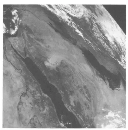
Figure 2. Meteosat image acquired on 10 February 1991, showing smoke plumes from Kuwait's oil well fires just west of the Arabian Gulf
The primary environmental sensor on NOAA satellites is the AVHRR. It is a five-channel scanning radiometer that is sensitive in the visible, near-infrared, and thermal-infrared bands. Its data can be recorded in 1.1 km resolution (the basic resolution of the AVHRR instrument) or at 4 km resolution; the swath width is 2600 km. The stored high resolution (1.1 km) imagery is known as Local Area Coverage (LAC). Owing to the large numbers of data bits, only 11 minutes of LAC can be accommodated on a single recorder. In contrast, 115 minutes of the lower resolution (4 km) imagery, called Global Area Coverage (GAC), can b...
Table of contents
- Cover
- Half Title
- Title
- Copyright
- Original Title
- Original Copyright
- Contents
- Preface
- Chapter 1. Detection by Satellite Images of Environmental Change Due to the Gulf War
- Chapter 2. The Gulf Marine Environment: Variations, Peculiarities, and Survival
- Chapter 3. Wind Regime of the Arabian Gulf
- Chapter 4. Modeling of Air Currents in the Gulf Region
- Chapter 5. Simulation of Short-Term Atmospheric Dispersion of SO2 Resulting from the Kuwait Oil Fires
- Chapter 6. Environmental Dimensions of the Gulf War: Potential Health Impacts
- Chapter 7. The Impact of the Gulf War on the Desert Ecosystem
- Chapter 8. Gulf War Disruption of the Desert Surface in Kuwait
- Chapter 9. Wind Erosion and Its Control
- Postscript
- Index
Frequently asked questions
Yes, you can cancel anytime from the Subscription tab in your account settings on the Perlego website. Your subscription will stay active until the end of your current billing period. Learn how to cancel your subscription
No, books cannot be downloaded as external files, such as PDFs, for use outside of Perlego. However, you can download books within the Perlego app for offline reading on mobile or tablet. Learn how to download books offline
Perlego offers two plans: Essential and Complete
- Essential is ideal for learners and professionals who enjoy exploring a wide range of subjects. Access the Essential Library with 800,000+ trusted titles and best-sellers across business, personal growth, and the humanities. Includes unlimited reading time and Standard Read Aloud voice.
- Complete: Perfect for advanced learners and researchers needing full, unrestricted access. Unlock 1.5M+ books across hundreds of subjects, including academic and specialized titles. The Complete Plan also includes advanced features like Premium Read Aloud and Research Assistant.
We are an online textbook subscription service, where you can get access to an entire online library for less than the price of a single book per month. With over 1.5 million books across 990+ topics, we’ve got you covered! Learn about our mission
Look out for the read-aloud symbol on your next book to see if you can listen to it. The read-aloud tool reads text aloud for you, highlighting the text as it is being read. You can pause it, speed it up and slow it down. Learn more about Read Aloud
Yes! You can use the Perlego app on both iOS and Android devices to read anytime, anywhere — even offline. Perfect for commutes or when you’re on the go.
Please note we cannot support devices running on iOS 13 and Android 7 or earlier. Learn more about using the app
Please note we cannot support devices running on iOS 13 and Android 7 or earlier. Learn more about using the app
Yes, you can access The Gulf War and the Environment by Farouk El-Baz,R.M. Makharita in PDF and/or ePUB format, as well as other popular books in Social Sciences & Regional Studies. We have over 1.5 million books available in our catalogue for you to explore.