This book advances the scientific understanding, development, and application of geospatial technologies related to water resource management. It presents recent developments and applications specifically by utilizing new earth observation datasets such as TRMM/GPM, AMSR E/2, SMOS, SMAP and GCOM in combination with GIS, artificial intelligence, and hybrid techniques. By linking geospatial techniques with new satellite missions for earth and environmental science, the book promotes the synergistic and multidisciplinary activities of scientists and users working in the field of hydrological sciences.
eBook - ePub
Geospatial Technology for Water Resource Applications
- 326 pages
- English
- ePUB (mobile friendly)
- Available on iOS & Android
eBook - ePub
Geospatial Technology for Water Resource Applications
About this book
Trusted by 375,005 students
Access to over 1 million titles for a fair monthly price.
Study more efficiently using our study tools.
Information
Section IV
Artificial Intelligence and Hybrid Approaches
13
CHAPTER
CHAPTER

A Deterministic Model to Predict Frost Hazard in Agricultural Land Utilizing Remotely Sensed Imagery and GIS
ABSTRACT
Frost risk is a critical factor in agricultural planning and management and has a significant impact on the environment and society. The ability to map the spatiotemporal distribution of frost conditions over a given area has improved dramatically nowadays with the rapid technological developments in Earth Observation (EO) technology and Geographical Information Systems (GIS).
In this study, a deterministic frost risk mapping model for agricultural crops cultivated in Mediterranean environments is proposed. The model is based on the main factors that govern frost risk including environmental parameters such as land surface temperature and geomorphology. Its implementation is based primarily on Earth Observation (EO) data from MODIS and ASTER polar orbiting sensors, supported also by ancillary ground observation data. Topographical parameters required in the model include the altitude, slope, steepness, aspect, topographic curvature and extent of the area influenced by water bodies. Additional data required include land use and vegetation classification (i.e. type and density).
The model has been tested in a region of primarily agricultural land located towards the northwestern part of the Greek mainland. The model’s ability to predict frost conditions for the winter period was validated for four selected years (i.e. 2004, 2006, 2009 and 2010). In addition, model predictions were compared against ground observations of frost damage in agricultural crops acquired from field surveys conducted by the Greek Agricultural Insurance Organization.
The results obtained verified the ability of the model to produce reasonable estimations of the spatio-temporal distribution of frost conditions in our study area, following the largely explainable patterns in respect to the study site’s geomorphological and local weather condition characteristics. Overall, the proposed methodology proved to be capable of detecting frost risk in Mediterranean environments in a time efficient and cost effective way, making it a potentially very useful tool for agricultural management and planning. The proposed model may be used as an important tool for frost mapping, a natural hazard that leads to severe vegetation damage and agricultural losses.
KEYWORDS: Remote sensing, GIS, frost, MODIS, risk assessment, Greece.

Frost has been globally identified as a leading agricultural hazard, as it can occur in almost any location, outside the tropical zones (FAO 2005). About two thirds of the world’s landmass is annually subjected to temperatures below the freezing point and about half of it suffers from temperatures below – 20°C (Larcher 2001). Frost can be described as a meteorological event when crops and other plants experience freezing injury due to occurrence of an air temperature less than 0°C (FAO 2005).
Huge economic losses caused by freezing of sensitive horticultural crops are observed throughout the world. For example, the citrus industry in Florida has been occasionally devastated by frost damage (Cooper et al. 1964; Martsolf et al. 1984; Attaway 1997), coffee production in Brazil has been seriously damaged by frost (Hewitt 1983) and winterkill of cereals is a major problem (Stebelsky 1983; Caprio & Snyder 1984a; Cox et al. 1986). Apart from the economic losses, there are also significant secondary effects on local and regional communities, such as unemployment (FAO 2005).
Many countries in temperate and arid climates experience economic and social problems due to frost damage, especially at high elevations (FAO 2005). Even in a Mediterranean country, such as Greece, compensations for frost damage in crops reach to an amount of 82 million euro per year, which is 32% of the total agricultural compensations (ELGA 2000-2010 data). Frost damage can be a serious hazard for many types of temperate climate crops. It may damage leaves and fruit and have significant impact on plants’ health (even destroy it). The level of frost injuries on a plant depends on the severity of the frost event and on the particular plant’s susceptibility (Richards 2003).
Minimum land temperature distribution in an area controls vegetation zonation and productivity of plants. It also affects most biotic processes such as plant phenology, growth, evapotranspiration, moisture requirements, carbon fixation and decomposition in natural and cultivated mountain ecosystems (Kramer 1983; Waring & Schlesinger 1985; Aber & Melillo 1991; Chen et al. 1999). Tree growth, species composition and plants’ susceptibility to disturbance are impacted cumulatively in a significant level (Turner & Gardner 1991).
Depending on vegetation structure, landscape position or soil properties, frost can damage plant tissues thus affecting forest, pasture and crop productivity (Blennow & Lindkvist 2000). Frost may cause scorching and browning of young leafs and buds, fruit and flower drop, development of misshapen fruits, as presented in Figures 1(a)-(f) (ELGA – GAIO 2003).
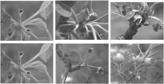
Figure 1 Frost damage on apple trees in the stage of (a) swollen buds, (b) bud burst, (c) green cluster, (d) bloom, (e) petal fall and (f) fruit set (ELGA 2003).
In the same plant, resistance to frost varies amongst its tissues. Meristematic cells are in general less fro...
Table of contents
- Cover
- Half Title
- Title Page
- Copyright Page
- Table of Contents
- Preface
- List of Contributors
- Section I General
- Section II Geographical Information System Based Approaches
- Section III Satellite Based Approaches
- Section IV Artificial Intelligence and Hybrid Approaches
- Section V Challenges in Geospatial Technology For Water Resources Development
- Index
- About the Editors
Frequently asked questions
Yes, you can cancel anytime from the Subscription tab in your account settings on the Perlego website. Your subscription will stay active until the end of your current billing period. Learn how to cancel your subscription
No, books cannot be downloaded as external files, such as PDFs, for use outside of Perlego. However, you can download books within the Perlego app for offline reading on mobile or tablet. Learn how to download books offline
Perlego offers two plans: Essential and Complete
- Essential is ideal for learners and professionals who enjoy exploring a wide range of subjects. Access the Essential Library with 800,000+ trusted titles and best-sellers across business, personal growth, and the humanities. Includes unlimited reading time and Standard Read Aloud voice.
- Complete: Perfect for advanced learners and researchers needing full, unrestricted access. Unlock 1.4M+ books across hundreds of subjects, including academic and specialized titles. The Complete Plan also includes advanced features like Premium Read Aloud and Research Assistant.
We are an online textbook subscription service, where you can get access to an entire online library for less than the price of a single book per month. With over 1 million books across 990+ topics, we’ve got you covered! Learn about our mission
Look out for the read-aloud symbol on your next book to see if you can listen to it. The read-aloud tool reads text aloud for you, highlighting the text as it is being read. You can pause it, speed it up and slow it down. Learn more about Read Aloud
Yes! You can use the Perlego app on both iOS and Android devices to read anytime, anywhere — even offline. Perfect for commutes or when you’re on the go.
Please note we cannot support devices running on iOS 13 and Android 7 or earlier. Learn more about using the app
Please note we cannot support devices running on iOS 13 and Android 7 or earlier. Learn more about using the app
Yes, you can access Geospatial Technology for Water Resource Applications by Prashant K. Srivastava, Prem Chandra Pandey, Pavan Kumar, Akhilesh Singh Raghubanshi, Dawei Han, Prashant K. Srivastava,Prem Chandra Pandey,Pavan Kumar,Akhilesh Singh Raghubanshi,Dawei Han in PDF and/or ePUB format, as well as other popular books in Biological Sciences & Biology. We have over one million books available in our catalogue for you to explore.