![]()
ENGLAND
In the new stone age, an irregularly shaped house 3.5m by 3m supported by about six vertical posts, and with an entrance on the southern side, stood here. The remains were obscured by those of a Roman villa, but the neolithic house seems to have been roughly hexagonal or possibly D-shaped in plan.
DRUID STOKE | Bristol | ST: 561762 |
This possible chambered long barrow site consists of a rectangular area of displaced stones. One massive slab 3m long is still supported by a smaller stone upright. The site was excavated in 1913, but without any positive results or finds, so its status remains uncertain.
FAIRY TOOTE | Nempnett Thrubwell | c. ST: 5360 |
This destroyed Cotswold-Severn tomb was first opened in 1788. Although the monument was almost entirely destroyed by 1835, some of its details were recorded. The number of pairs of side chambers varies according to source – some say six, others eight – but it is a large number, whichever is correct. The chamber complex was larger than that at Stoney Littleton, about 26m long, compared with Stoney Littleton’s 18m. Bones were found in the chambers in some numbers: ‘in one of them 7 skulls were found, one quite perfect; in another a vast heap of small human bones and horses’. At Fairy Toote, it looks as if the human remains were disarticulated and sorted before they were buried in the tomb, suggesting a two-phase funerary ritual that seems to have prevailed throughout Britain.
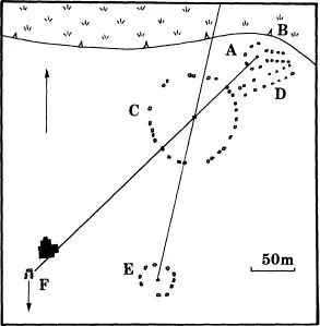
This group of three stone circles lying low on the Chew valley floor includes the second largest circle in Britain, and yet the monument is far from well known. The site’s potential impressiveness is greatly reduced by its low-lying location, backing onto a farmyard, the low ridge separating the South-West Circle from the Great Circle, and the positioning of the parish church of St Mary’s between the Cove and the rest of the ritual complex. The monument as a whole is generally considered to consist of the three stone circles, the Cove, two short and badly damaged stone avenues, and an outlying stone known as Hautville’s Quoit. Although at first sight the arrangement of these elements looks casual and informal, there are detectable alignments which are almost certainly part of the original design. The North-East Circle, the Great Circle and the Cove all lie on the same straight line (SW–NE). The South-West Circle, the Great Circle and Hautville’s Quoit lie on a different line running SSW–NNE.
Figure 3 Stanton Drew. A – North-East Circle, B – stone avenue leading from North-East Circle to water meadows, C – Great Circle, D – stone avenue leading from Great Circle to water meadows, E – South-West Circle, F – Cove, facing south. The site’s geometry has been drawn in, showing the alignment of the Cove, Great Circle and North-East Circle, and the alignment of the South-West Circle, Great Circle and Hautville’s Quoit, which is off the map.
Of the 30 stones in the Great Circle, only 3 are still standing: the rest have fallen. They make a circle 113m in diameter. One or two of the stones are sarsens, the rest are the local dolomitic conglomerate. The Great Circle stands in a level meadow a little above the Chew floodplain, the edge of which lies only 40m away to the north; a short avenue of stones leads away to the north-east, as if to connect the Great Circle to the watermeadows. Near the north-east end of the avenue is the North-East Circle, a much smaller monument 30m across and consisting of only eight stones, four of which are still upright. The North-East Circle has its own avenue, also of eight stones, which leads eastwards and seems to get tangled up with the terminus of the Great Circle avenue. Their orientation towards the wet floodplain of the River Chew suggests that water may have played some part in the religious beliefs of the monument builders.
The South-West Circle, on the southern slope of a low ridge that separates it from the Great Circle, is a little larger than the North-East Circle, 40–43m across. It consisted of 11 or 12 stones, all of which have now fallen. Due west of the South-West Circle is the Cove, a box-like setting of three very large stones arranged along three sides of a square. The fourth side, to the south, is open, suggesting an orientation to the sun’s zenith. The back or central stone has unfortunately fallen. The building of the parish church right next to the Cove is reminiscent of the juxtaposition of church and monolith at Rudston. Hautville’s Quoit, now also fallen, lies some 360m NNE of the Great Circle; as an outlier, it may have served as an astronomical marker of some kind, but this has not been proved.
Rather surprisingly, Stanton Drew has been neglected by archaeologists. It has never been excavated, but it seems likely to belong to the late neolithic, possibly around 2600 BC (Figure 3).
STONEY LITTLETON | ST: 735572 |
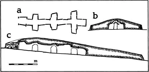
This very fine chambered long barrow of Cotswold-Severn type was carefully and beautifully restored in 1858. The grass-covered mound is 30m long and 15m wide, contained within a well-made drystone retaining wall, which gives it the appearance of a turf-roofed house. At the south-east end there is a horned entrance with a fossil ammonite cast on the western door jamb; whether the positioning of the decorative fossil at the tomb entrance was inadvertent is open to speculation, but the form is reminiscent of the neolithic spiral carvings deliberately placed at tomb entrances at Newgrange and Pierowall, so it may well have been selected for its symbolic value. The entrance leads into a low-ceilinged gallery with three pairs of side chambers and an end chamber. The gallery is 15m long but only a metre or so high: crawling is easier than walking here. In 1816, the Revd John Skinner broke in through the roof to explore the tomb chambers. He found many human bones and fragments of pottery (Figure 4).
Figure 4 Stoney Littleton, a Cotswold–Severn chambered long cairn. a – plan of the transepted chambers, b – cross section, c – long profile.
BARTON HILL FARM | Streatley | TL: 094282 |
This middle neolithic henge barrow was discovered from air photographs in 1948. The foundation trench of a wooden mortuary enclosure and two crouched burials were enclosed inside a circular ditch 30m in diameter. The ditch and external bank were broken by an entrance causeway, and from this a row of posts led to a site consisting of a number of overlapping pits.
BISCOT MILL LONG BARROW | Luton | TL: 079232 |
The exact location of this destroyed long barrow is not known for certain, although it seems likely that it was the mound on which Biscot Windmill was built. This stood behind what is now the Biscot Mill public house. Two polished greenstone axes have been found here, which suggests that it was a neolithic site of some kind.
CARDINGTON CAUSEWAYED ENCLOSURE | TL: 093484 |
A causewayed enclosure site in a field called Stonyland Furlong. The misshapen circular precinct is enclosed by three closely spaced interrupted ditches. The small straight-sided enclosures which lie within it, and also across the ditches and outside, probably relate to a later prehistoric occupation of the site. Close by, at TL: 092502, cropmarks indicate the existence of mortuary enclosures, an oval barrow and a cursus.
DUNSTABLE DOWN LONG BARROW | TL: 012222 |
An earthen long barrow 30m long, forming part of the Five Knolls Barrow Cemetery on Dunstable Down.
FURZENHILL FARM CURSUS | TL: 196466 |
A possible cursus showing as a cropmark.
GALLEY HILL BARROW LONG | Streatley | TL: 086268 |
This long barrow, destroyed in about 1900, lay to the west of Galley Hill. Air photographs show it to have been 90m long; this seems incredibly long for a Chiltern long barrow, but it may be that it was spread during destruction and was originally significantly shorter. Excavation produced Windmill Hill pottery and human bones.
GOLDINGTON HENGES | TL: 078504 |
The earliest monument at this complex ritual site was a henge with a single entrance to the south-west. Its ditch, 2.5m wide and 2m deep, encircled a precint 25m in diameter. The ditch was open for a time and full of water, forming a kind of moat, before it was deliberately filled in using material from its inner bank. There was apparently no external bank....