Designed for all libraries, this large-format, full-color atlas is an authoritative guide to the history of the United States. From the formation of the continent up through current events and information based on the most recent census, this work uses the geography of the United States to portray the history of the land and its people. The 300-plus maps tell the engaging story of America with detailed, clear information; accompanying text highlights key information presented in each map.
An indispensable tool for students and educators alike, the Historical Atlas of the United States is destined to become a classic in the field.
- 240 pages
- English
- ePUB (mobile friendly)
- Available on iOS & Android
eBook - ePub
Historical Atlas of the United States
About this book
Trusted by 375,005 students
Access to over 1.5 million titles for a fair monthly price.
Study more efficiently using our study tools.
Information
PART ONE
NORTH AMERICA: GEOGRAPHY, CLIMATE, TOPOGRAPHY
HUMAN BEINGS have always clung to the notion that the earth is “solid.” We contrast its permanence with the churning seas of the oceans and the unfathomable void of the heavens. From time immemorial, to claim land as their own, farmers have fenced it off and statesmen have built walls around it. For over five centuries cartographers have inscribed lines of latitude and longitude upon the planet, translating its fixity into mathematical precision. The implicit message conveyed by these actions is that while time changes, and people live and die, the earth remains immovable.
But our commonsensical understanding of the “solid earth,” like so many other seemingly incontrovertible verities, is a myth. Like so many other myths, it is a product of our myopia, our inability to see beyond the boundaries of our own time and place.
Scientists have proven, and fairly recently, that the earth beneath our feet is anything but solid. The crucial insights were an unanticipated consequence of World War II and its aftermath. Harry Hess, a Princeton geologist who had devised a machine to map the ocean floor, tried it out while commanding a U.S. troopship in the Pacific. As he ferried his men to and from battle, his machine charted the contours of the ocean floor. His data showed that beneath thousands of feet of water, hundreds of small volcanoes dotted the floor of the Pacific, their tops apparently lopped off by ocean currents. Why volcanoes were so common in the deep seas he could not say.
A decade later, geologists with even finer mapping tools, many of which had been developed to monitor nuclear explosions, discovered that the undersea volcanoes perforated the ocean floors along lines or arcs, which apparently constituted seams in the ocean floor. They soon perceived that these edges continued above ground as fault lines on the earth’s surface. Thus was born the new science of plate tectonics. And it set scientists into fervent consultation.
The science of plate tectonics advanced the theory that the surface of the earth consists of nearly two dozen slabs, each about 60 miles thick. These slabs, or plates, float upon molten materials. When the plates were somehow heaved above the surface of the oceans, they constituted continents. These discoveries, combined with abundant archaeological findings of marine fossils in modern deserts or fossils of desert-creatures in stones drawn from the depths of the ocean, suggested not only that the earth moved but that it was always moving.
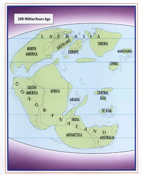
Plate tectonics modified the theory of Alfred Wegener, a German meteorologist who early in the 20th century had contended that over hundreds of millions of years the continents, once lumped in a single landmass, had drifted apart. While Wegener had failed to adequately explain the nature of the force behind continent drift, plate tectonics supplied the answer. The plates beneath the oceans, under tremendous stress from the weight of the water, crumbled along their edges. Molten materials pushed upward through the cracks. As these cooled and hardened, they functioned like giant wedges that forced the plates outward, like toothpaste being squeezed between ice cubes. As these plates collided with others, they would bend and buckle, or one would slide beneath another, forcing the latter upward.
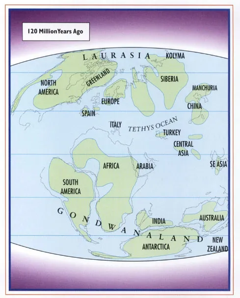
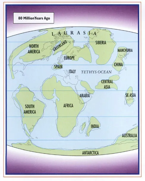
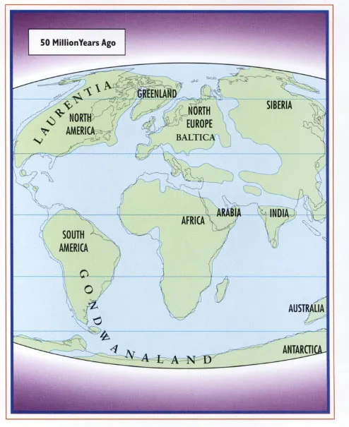
Most scientists now believe that about 500 million years ago, much of the Northern Hemisphere—including what is now North America—was open ocean, though perhaps only a few feet deep, while the plates containing large landmasses were mostly conjoined south of the equator. During the next 100–150 million years, some of these plates fractured and were pushed northward. Around 100 million years ago, the plate that became North America had moved toward the Tropic of Cancer, and around 50 million years ago North America was nearly in its present position and shape.
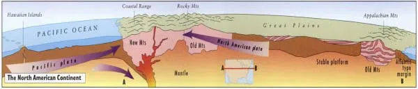
As the plates of the eastern Pacific pushed farther east, they collided with the main plates holding the North American continent. The consequent buckling and lifting formed the mountain ranges of the Far West. These profoundly affected the climate of the continent, as westerly winds laden with water from the Pacific were forced higher, dumping rainfall on the Pacific Northwest and depriving the skies over the Rocky Mountain states and western plains of moisture. The extreme climate fluctuations of the United States are largely a consequence of its geology.
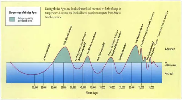
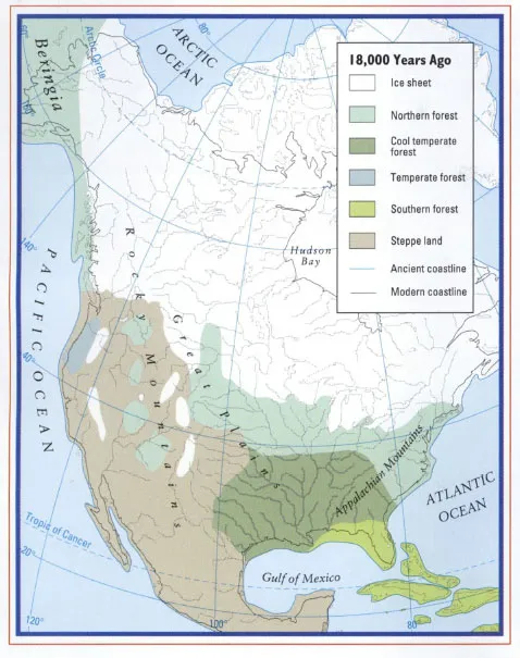
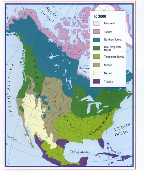
The climate has been influenced by other factors as well. The period ranging from 110,000 until 18,000 years ago was unusually cold, with temperatures worldwide perhaps 5°C lower than present. Most of what is now Canada was covered by glaciers. Eighteen thousand years ago the earth began to warm, probably due to a slight shift in the earth’s orbit of the sun. By 9,000 years ago, the climate of the Northern Hemisphere was warmer than even today. In consequence, the glaciers receded, having gouged vast pits that became the Great Lakes, Finger Lakes, and other bodies of water.
The slowly evolving geology, and the vicissitudes of climate, show that while human beings make history, their actions are always impinged on by environmental factors over which they have little control.
MAPS
200 Million Years Ago
120 Million Years Ago
80 Million Years Ago
50 Million Years Ago
Chronology of the Ice Ages (Diagram)
18,000 Years Ago
AD 2000
The North American Continent (Cross-section)
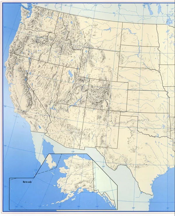
The Importance of Topography in U.S. History
Native Vegetation c. AD 1620
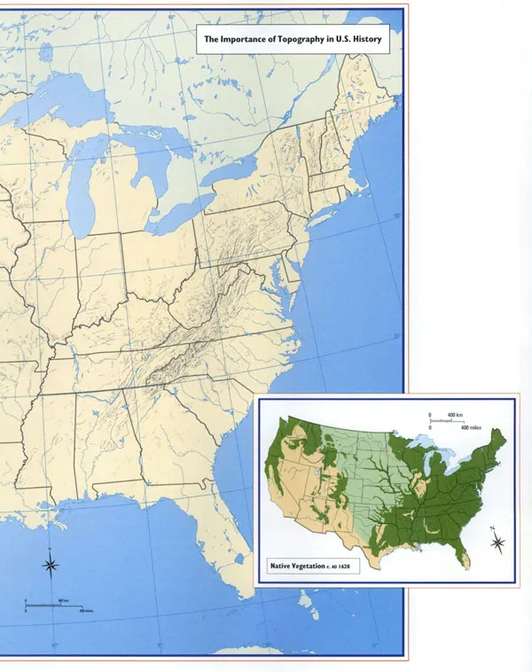
The topography of the United States has figured prominently in its history. The Appalachians long constituted a barrier to English settlers, who settled along the Atlantic coastal plain. In consequence, the original colonies were knit together by coastal shipping, along a north–south axis, with port cities such as New York, Boston, and Philadelphia serving as the focus of colonial life. Later the Mississippi River and its tributaries, which watered the nation’s central plain, created another economic region, the nation’s grainery; midwestern farmers, floated their produce I downriver to markets New Orleans and beyond.
But the nation’s earliest cities during the 1% century became its largest ones, and the demand for food in the cities of the Mid-Atlantic and New England provided the stimulus for the development of the railroads across the Appalachians, superimposing east-west transport grid.
The Rocky Mountains constituted a yet more formidable barrier, accentuating California’s cultural ties with Mexico. They were also a place of refuge. In the region around Salt Lake, the Mormons built an empire beyond ready interference by federal authorities of the United States; there, too, m remote mountains, Indian rebels for a time evaded reservation life, and desperadoes, the clutches of frontier lawmen.
PART TWO
FIRST AMERICANS
AMERICAN HISTORY indeed, all human history—can perhaps be understood as a tension between acraving to be on the move and an equally powerful desire to set down roots. We seek the thrill of exploration and discovery as well as the comfort of repose and relaxation. We have a restless urge to be elsewhere; once there, we long to be home.
Unlike us, the earliest human beings were nearly always in motion. As hunters, they traveled constantly, following herds of large animals or attending to shifts in the seasons in search of fruits or edible ...
Table of contents
- Cover
- Halftitle
- Title
- Copyright
- Contents
- Introduction
- Part One North America: Geography, Climate, Topography
- Part Two First Americans
- Part Three Across The Waters: Explorations and Outposts
- Part Four Contested Borders: Indians and Europeans in 17th Century America
- Part Five European Wars and American Consequences
- Part Six 18th Century American Society
- Part Seven War and Revolution 1775–1783
- Part Eight Forging the New Nation
- Part Nine People and Society
- Part Ten Growth of the Nation Through the War of 1812
- Part Eleven Opening of the West
- Part Twelve The Coming of the Civil War
- Part Thirteen The Civil War
- Part Fourteen Reconstructing the South and Closing the Frontier
- Part Fifteen America in the Gilded Age
- Part Sixteen Crusaders Abroad and Reformers at Home
- Part Seventeen The Twenties and Thirties
- Part Eighteen War War II
- Part Nineteen The Cold War
- Part Twenty America in the Fifties and Sixties
- Part Twenty–One Contemporary Challenges at Home and Abroad
- Special Sections:
- Selected Bibliography
- Index
- Acknowledgments
Frequently asked questions
Yes, you can cancel anytime from the Subscription tab in your account settings on the Perlego website. Your subscription will stay active until the end of your current billing period. Learn how to cancel your subscription
No, books cannot be downloaded as external files, such as PDFs, for use outside of Perlego. However, you can download books within the Perlego app for offline reading on mobile or tablet. Learn how to download books offline
Perlego offers two plans: Essential and Complete
- Essential is ideal for learners and professionals who enjoy exploring a wide range of subjects. Access the Essential Library with 800,000+ trusted titles and best-sellers across business, personal growth, and the humanities. Includes unlimited reading time and Standard Read Aloud voice.
- Complete: Perfect for advanced learners and researchers needing full, unrestricted access. Unlock 1.5M+ books across hundreds of subjects, including academic and specialized titles. The Complete Plan also includes advanced features like Premium Read Aloud and Research Assistant.
We are an online textbook subscription service, where you can get access to an entire online library for less than the price of a single book per month. With over 1.5 million books across 990+ topics, we’ve got you covered! Learn about our mission
Look out for the read-aloud symbol on your next book to see if you can listen to it. The read-aloud tool reads text aloud for you, highlighting the text as it is being read. You can pause it, speed it up and slow it down. Learn more about Read Aloud
Yes! You can use the Perlego app on both iOS and Android devices to read anytime, anywhere — even offline. Perfect for commutes or when you’re on the go.
Please note we cannot support devices running on iOS 13 and Android 7 or earlier. Learn more about using the app
Please note we cannot support devices running on iOS 13 and Android 7 or earlier. Learn more about using the app
Yes, you can access Historical Atlas of the United States by Mark C. Carnes in PDF and/or ePUB format, as well as other popular books in History & Historical Geography. We have over 1.5 million books available in our catalogue for you to explore.