- 256 pages
- English
- ePUB (mobile friendly)
- Available on iOS & Android
eBook - ePub
About this book
This handbook provides a ready introduction and practical guide to the Abkhazian people and language. It includes chapters written by experts in the field, covering all aspects of the people, including their history, religion, politics, economy, culture, literature and media, plus pictures, chronologies and appendices of up-to-date statistics, maps and bibliographies.
This volume forms part of the Peoples of the Caucasus series which is an indispensable - and accessible - resource to all those with an interest in the Caucasus: journalists, aid workers, regional specialists in government, law, banking, accounting, as well as tourists, business people, students and academics.
Trusted by 375,005 students
Access to over 1.5 million titles for a fair monthly price.
Study more efficiently using our study tools.
Information
1
Geography & the environment
Roman Dbar
The Republic of Abkhazia lies in the north-west Transcaucasus. The north-western and northern border of the Republic of Abkhazia first runs along the River Psou and then along the crest of the main watershed-ridge of the Greater Caucasus. In this sector it borders the Krasnodar and Stavropol regions of the Russian Federation. In the east the border passes along the Abkhaz-Svanetian (SakJ'an) ridge, the southern spur of the K'odor (Panajw) ridge, and the lower course of the River Ingur. Here the Republic of Abkhazia borders the Republic of Georgia, specifically its ethnographic provinces of Svanetia and Mingrelia, In the south the territory of the Republic of Abkhazia is washed by the waters of the Black Sea.
The average length of the territory of Abkhazia from north-west to south-east is 170km, and from south to north 66km. It lies between the northern latitudes of 43°35' and 42°27' and the eastern longitudes of 40° and 42°08'. The general area of the country is 8,700km2.
Geomorphology
Abkhazia is a typical mountainous country. Almost the whole of its territory is covered with high, sharply dissected mountain-chains. If from the height of the main ridge of the Greater Caucasus one casts a glance over the mountain chains in Abkhazia, they make one think of gigantic waves of stone, congealed in their passage and gradually descending to the shore of the Black Sea. The incline of the territory of Abkhazia runs in a general direction from the south-west to the northeast.
The mountainous area is girded by hilly approaches which turn into the low-lying coastal plain in the east of the country or come to an abrupt end at the seashore in the west. The main ridge of the Greater Caucasus enters the frontiers of Abkhazia near the sources of the River Awadhara (Wadhara). Here on the north-western border the mountains
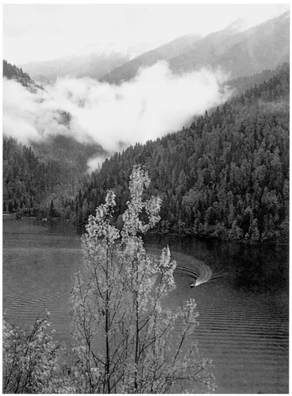
Lake Rits'a, nestling amidst high peaks 950m above sea-level in Northern Abkhazia, is one of Abkhazia's main natural attractions; 2,490m long, its maximum depth is 116m
rise to 2,500m above sea-level. Towards the south-eastern ridge there is an increase in height, and on the eastern border the Abkhazian mountain-chains already heave up to between 3,500 and 4,000m.
Passes across the main ridge within the confines of Abkhazia lie at heights of between 2,300 and 3,000m above sea-level. It is because of this that the majority of them are difficult to reach and for most of the year are closed for passage. The most manageable for passage is the K'lukhor Pass on the Abkhazian (Sukhum) Military Highway. The last century saw the growth of a great deal of traffic across the Marukh Pass as well. These passes are paths which are suitable for travel either by people on foot or by packhorse.
By the foothills of the southern slope of the Greater Caucasus lie deep longitudinal valleys along which rivers flow. The most significant of these are the Awadhara, Bavju, Baul (tributaries of the River Bzyp) and Chkhalta, as well as the upper course of the K'odor and the lower course of the Sak'en (Sakfan).
Valleys in the upper reaches carry traces of the movement of ancient glaciers, whilst in the lower reaches the rivers flowing along them cut into morainal deposits, forming terraces. In the extreme east of Abkhazia a belt of longitudinal valleys is sealed off by the Abkhaz-Svanetian (Saki'an) ridge — this is a high eroded spur of the Greater Caucasus which forms a watershed between the river basins of the K'odor and Ingur. The highest point of the ridge is the summit of Mount Khwarikhra (3,710m).
In the east of Abkhazia from the summit of Khodzhal (3,309m) as far as the River K'odor, parallel to the main ridge, there rises the powerful latitudinal swell of the K'odor ridge, compacted with dense tufaporphyritic rocks. Its blade-shaped crests and rocky peaks vie with the main chain itself of die Greater Caucasus for steepness and height.
In the north-east of die country, parallel with the main ridge, runs the Chkhalta ridge, which extends in the west to the Chedym ridge (the peak of Mount Khjymsa rises to 3,150m). The saw-shaped crests of these ridges, jagged with deep sand-filled holes eroded by ancient ice-formations, are bearers of small modern glaciers.
The relief to the south of this arc of ridges, weakly concaved in the north, is characterised by alternating meridional eroded, denuded ridges or deep river-bearing ravines.
A large portion of the territory in the north-west is taken up by two vast limestone massifs — that of Gagra (Arabika peak is 2,660m) and that of Bzyp (Nap'ra peak is 2,684m). These massifs are compounded with powerfully thick deposits of limestone, attenuated into gently sloping pleats and distinguished by active karsting processes. Here it is that one finds one of the largest caves on the planet — that of New Athos (= Afon Ts̨'yts; its internal volume is 1.5 million m3), as well as one of the deepest — the Snowy Cave, with a charted depth of 1,300m.
In the eastern part of Abkhazia the zone of limestone development is quite narrow, and all the limestone ridges are separated by a distinct ledge from the belt of hilly mountain-approaches, which sink in the south to the sea-coast. The foothills descend and turn into a flat coastal plain. In the north-west this occurs only as separate strips in riverestuaries, whilst to the east of Sukhum it widens out into a broad continuous zone, reaching the Samurzaq'an(o) depression up to a width of 30m.
One can therefore divide Abkhazia geomorphologically into four longitudinal zones:
- the zone of the main ridge of the Greater Caucasus
- a zone of rolling, rocky ridges with deep longitudinal and transversal riverbeds
- a zone of hilly mountain-approaches
- a zone of coastal alluvial depression, consisting of separate sections — those of Tsandrypsh, Bzyp, Gudauta, Sukhum, Abzhywa and Samurzaq'an(o).
Climate
Abkhazia is characterised by a sharply pronounced vertical differentiation of climatic zones and an exceptional variety of climatic conditions. In the course of the 50km from the shore of the Black Sea up to the main ridge of the Greater Caucasus it is possible to experience all the climatic zones from humid subtropical to an arctic waste of eternal snows and glaciers.
Such a variety of climatic states is conditioned by the intricate composition of the complex of physical-geographical peculiarities — radiation from the sun and circulatory phenomena in the atmosphere, peculiarities of orography and the very important climatic factor that is the moderating activity of the Black Sea.
The territory of Abkhazia lies at the intersection of two of the terrestrial globe's climatic zones — the subtropical and die temperate. As regards the amount of direct radiation from the sun at warm times of the year, Abkhazia is akin to the Japanese subtropics, and at cold times of the year to the subtropics of the Mediterranean countries of Europe.
Winter in Abkhazia is the warmest in the entire territory of the former USSR. Average temperatures in January in the Gagra region are +7°C and in die environs of New Athos even higher at +7.1°C.
The capital of Abkhazia, the town of Sukhum (Aqw'a), lies 80km south of Gagra, and here the average temperatures in January are +6°C. Further to the south the average temperatures fall, ignoring, as it were, the geographical latitude. In the towns of Ochamchira and Gal they are equivalent to +4.1°C. This phenomenon is conditioned by the lower protection afforded by the mountain ridges of the southern coastal depressions against encroachment by cold masses of air.
As the location rises, the average temperatures fall. Drop in temperature per 100m in height, starting from a height of 250m above sea-level, is around 0.6°C. This explains why the average temperatures for January on the main Caucasian ridge can reach as low as −20°C.
Because of the influence of the Black Sea, the period for the approach of maximum temperatures is one month late (occurring in August) in comparison with localities in conditions of a continental climate. The mean temperatures in August on the coast are equal to +23°C. The highest mean temperatures in the hottest month are found at the resort of Gagra, standing at +24.5°C.
The yearly amount of precipitation and its distribution across the territory of Abkhazia is dependent upon the closeness of the sea, the direction of the prevailing air-masses, and the character of the terrain. The mean annual amount of precipitation is 1,400mm.
The amount of precipitation along the coast increases from north to south, but especially pronounced is the rise in precipitation as altitude increases. Thus, for example, Sukhum (35m above sea-level) receives 1,390mm of precipitation, whereas Ts'ebelda (Ts'abal — 426m above sea-level) gets 1,788mm. Higher still in the upper reaches of the River K'odor the amount of precipitation exceeds 2,000mm per year, whilst in separate high-mountainous regions, it is true, this magnitude may reach 4,000mm per year.
The average relative humidity in Sukhum is equal to 72 per cent. The number of hours of sunshine in the capital of the republic consists of 2,238 hours per year. The maximum occurs in summer (812 hours), and the minimum in winter (317 hours).
Hydrography
The coasts of Abkhazia extend a distance of 240km on the eastern littoral of the Black Sea. The most picturesque section of coast is in the region of Gagra, where for a distance of about 20km spurs of the Gagra limestone massif descend right up to the seashore, dropping down to it from a height of almost 2,000m in steep slopes, which form the grandiose Gagra cornice.
To the south of Gagra the ridges gradually draw back from the shore, giving way to hilly mountain-approaches. The latter in their turn become the flat Bzyp depression with the Pitsunda promontory. To the east of the promontory of Pitsunda lie the conglomerative Mysra hills (Mjussera), which attain a height of 200m. This is one of the most picturesque spots of Abkhazia's Black Sea coast. Here a colossal conglomerative block is cut off by the sea and forms a sheer rocky shore with narrow sandy beaches. To the south of Sukhum the shoreline of Abkhazia is lowlying and to a significant degree straight-lined.
On the bottom of the Black Sea three zones are quite distinct: the continental shelf, extending to a depth of 200m; the continental slope, stretching between 200m and 2,000m; and the bottom of the hollow, occupying the depths from 2,000m to 2,243m.
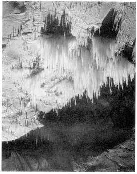
The massive cave complex at New Athos was discovered in 1961. There are nine galleries of stalactites and stalagmites, open to the public in a 'son et lumière' presentation
Close to the shores of Abkhazia, the width of the continental shelf varies sharply. At the Gagra cornice it does not exceed one kilometre, but opposite Gudauta it reaches 35km. The average transparency of the water around Sukhum is around five metres. The greatest transparency of the Black Sea waters around the shores of Abkhazia occurs at the time of the autumn calms and attains 27m. The average annual temperatures of the water at Sukhum are +17°C. At the hottest time of year, in August, the temperature of the surface of the water along the coastline can reach +27°C or +28°C. The salinity of the surface of the water fluctuates from 17.5 per cent (in winter) to 18.2 per cent (in summer). It increases the greater the depth, and in ground-layers it stands at 22.5 per cent.
In terms of its hydrophysical and hydrochemical properties, the Black Sea stands out sharply among all other sea-reservoirs on the planet, for the fundamental feature which sets it apart from all others is the sharp difference in water-density between the surface-layer in the
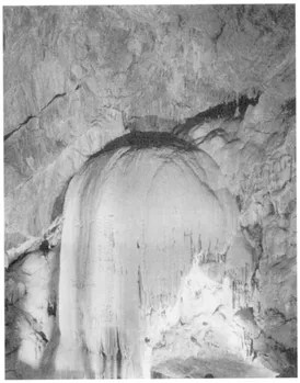
One of the strange shapes taken by some of the New Athos rock formations. Temperatures range between 12.6°C and 14.4°C in the caves.
range 100-150m, the oxygen layer, and the water-mass lying deeper down, the hydrogen-sulphide layer.
These two strata are sharply distinguished in terms of temperature, salinity, dissolved gases, content of biogenic substances, and distribution of life-forms. As a result of the heavy presence of hydrogen-sulphides the water layer of the Black Sea at depths below 150-200m is devoid of life, widi the exception of anerobic bacteria. As explained by Ascheron (1995, p4), the inrush of organic matter from the five major rivers that feed it (Kuban, Don, Dnieper, Dniester and Danube) is too much for the sea water, which would normally be expected to decompose it.
Internal waters
The territory of Abkhazia with its abundance of precipitation possesses a very dense surface hydrographical network, represented by mountin-glaciers, rivers, lakes, springs and bogs.1 The general glacial area in Abkhazia's mountains is equal to about 77km2, which represents four per cent of the whole Greater Caucasus. The glaciers encountered in the mountains of Abkhazia are basically of the pendant, valleyed and peaked varieties. As regards their size, the glaciers are not large, and only some exceed a length of two kilometres. In all there are 131 glaciers in Abkhazia, where in the main they feed the system of two rivers: the K'odor and the Bzyp.
Abkhazia's rivers typically display a bewitching charm and wild indomitability. Their crystal-clear waters rush headlong down from high mountain-ledges, scatter in the white froth of waterfalls, cut through deep narrow gorges and, b...
Table of contents
- Cover
- Title
- Copyright
- Dedication
- Contents
- Preface
- Introduction
- 1. Geography and the environment
- 2. Origin of the Abkhazian people
- 3. On the track of Abkhazia's antiquity
- 4. History: first-18th centuries
- 5. History: 18th century-1917
- 6. History: 1917-1989
- 7. Soviet Abkhazia 1989: a personal account
- 8. History: the modern period
- 9. Military aspects of the war: the battle for Gagra
- 10. The economy: traditional & modern
- 11. Language
- 12. Literature & linguistic politics
- 13. Art, handicrafts & architecture
- 14. Religion
- 15. Demography
- 16. Ethnic culture
- Further Reading
- Contributors
- Notes
- Index
Frequently asked questions
Yes, you can cancel anytime from the Subscription tab in your account settings on the Perlego website. Your subscription will stay active until the end of your current billing period. Learn how to cancel your subscription
No, books cannot be downloaded as external files, such as PDFs, for use outside of Perlego. However, you can download books within the Perlego app for offline reading on mobile or tablet. Learn how to download books offline
Perlego offers two plans: Essential and Complete
- Essential is ideal for learners and professionals who enjoy exploring a wide range of subjects. Access the Essential Library with 800,000+ trusted titles and best-sellers across business, personal growth, and the humanities. Includes unlimited reading time and Standard Read Aloud voice.
- Complete: Perfect for advanced learners and researchers needing full, unrestricted access. Unlock 1.5M+ books across hundreds of subjects, including academic and specialized titles. The Complete Plan also includes advanced features like Premium Read Aloud and Research Assistant.
We are an online textbook subscription service, where you can get access to an entire online library for less than the price of a single book per month. With over 1.5 million books across 990+ topics, we’ve got you covered! Learn about our mission
Look out for the read-aloud symbol on your next book to see if you can listen to it. The read-aloud tool reads text aloud for you, highlighting the text as it is being read. You can pause it, speed it up and slow it down. Learn more about Read Aloud
Yes! You can use the Perlego app on both iOS and Android devices to read anytime, anywhere — even offline. Perfect for commutes or when you’re on the go.
Please note we cannot support devices running on iOS 13 and Android 7 or earlier. Learn more about using the app
Please note we cannot support devices running on iOS 13 and Android 7 or earlier. Learn more about using the app
Yes, you can access The Abkhazians by George Hewitt in PDF and/or ePUB format, as well as other popular books in Social Sciences & Ethnic Studies. We have over 1.5 million books available in our catalogue for you to explore.