- 196 pages
- English
- ePUB (mobile friendly)
- Available on iOS & Android
eBook - ePub
Understanding Geology Through Maps
About this book
Understanding Geology through Maps guides young professional geologists and students alike in understanding and interpreting the world's dynamic and varying geological landscapes through the liberal use of visual aids including figures, maps, and diagrams.
This highly visual reference introduces the skills of interpreting a geological map and relating it to the morphology of the most important types of geological structure. Thoroughly revised, and with more international examples, it is ideal for use by students with a minimum of tutorial supervision.
Maps of geological structures provide all of the realism of a survey map without the huge amount of data often present, so readers can develop or hone their skills without becoming overwhelmed or confused. In particular, emphasis is placed throughout on developing the skill of three-dimensional visualization so important to geologists.
- Authored by a master geologist with more than 40 years of experience in research and instruction
- Features more than 130 figures, diagrams, and illustrations—many in full color—to highlight major themes and aid in the retention of key concepts
- Leads to a broad understanding of Earth's geology through the use of real and theoretical map
- Exercises conclude each chapter, making it an ideal tool for self-guided and quick study
Trusted by 375,005 students
Access to over 1.5 million titles for a fair monthly price.
Study more efficiently using our study tools.
Information
Chapter 1
Geological Maps and Some Basic Terminology
Abstract
Characteristics of layered rocks are explained including their correlation from one location to another. Uniformitarianism and the use of a stratigraphic column are introduced. Metamorphic, igneous, and plutonic rock relations are less easily interpreted from maps.
Keywords
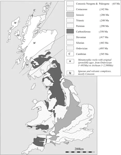
Clastic sedimentary rocks; Correlation; Faunal succession; Igneous rocks; Lithology; Mapping; Metamorphic rocks; Plutonic rocks; Sedimentary rocks; Stratigraphic correlation; Superficial deposits; Superposition; Uniformitarianism; Volcaniclastic sedimentary rocksWilliam Smith (1736–1839) created the first geological map in southern England (see Simon Winchester’s book, 2001 listed in the Foreword). He expanded it through his lifetime’s work to be a geological map of England and Wales which is little different from the map we know today (Figure 1.1 shows the modern geological map of the United Kingdom). His initial map focused on a small area around Bath (Figure 1.2). First appearing and acknowledged in 1799, and published in 1802, the original geological map provided a revolutionary breakthrough in that it provided a way of showing map distribution of rock types from which one could deduce their relative age (≈chronostratigraphic sequence) and three-dimensional configuration at depth from visual inspection of the surface map alone. The father of the geological map, Smith, grew up in a rural environment in Oxfordshire but was exposed to geology at an early age through an interest in the locally abundant fossils. Parenthetically, a wealthy nephew John Phillips became the first Professor of Paleontology and Geology at Oxford and in later life assisted his uncle from discrediting attacks by formally educated intellectuals. Most of the population denied the antiquity of fossils due to religious reasons or they attributed their presence to the effects of the biblical flood. However, William Smith, like other better educated and more fortunate natural philosophers, grew to suspect the great ages required for the accumulation of thick sequences of sediment (later to be lithified to become sedimentary rock). Despite the controversy about their origin, Smith was the first person to recognize that specific fossils characterized each stratigraphic horizon. A further quantum step in knowledge was made when he realized that the fossil content could then be used to correlate comparable sequences of rocks between different locations (Figure 1.3). The details for central and southern England differ little from Smith’s final compilation, which was published in 1815. With the benefit of recent geochronological work, the absolute ages of the geological periods have been established (Figure 1.4).
Smith introduced the term stratigraphical and stratigraphy about 1795. The worldwide stratigraphic column as we now know it is shown in Figure 1.4. One of the few pieces of memory work in studying this book is to become familiar with the sequence of names and their approximate geochronological ages. Stratum (plural strata) derives from the Latin for street, since the well-known Roman Roads of Britain (and elsewhere in Europe) have survived two millennia due to their well designed layered structure, from the foundation of gravel, through a sand layer, to cobbles at the top. Bed and bedding are more-or-less English synonyms for stratum and stratification, although strictly speaking “bed” would describe a sedimentary rock, whereas stratification also encompasses sequentially layered igneous rocks such as lavas and even layered magmatic rock.
Bedding plane is subtly and importantly different. It refers to the discrete horizon of no thickness, a stratum-parallel boundary that separates two different beds, e.g., between a bed of sandstone and a bed of limestone. A bedding plane represents some unknown interval of nondeposition that may have endured for seconds or thousands of years. James Hutton (1726–1797) recognized the importance of a very special class of bedding surface, the unconformity. Hutton, quite unlike Smith, was a formally educated scholar and a medical doctor and a Professor at the University of Edinburgh at the acme the intellectual interval known as the period of Scottish Enlightenment. Hutton observed tilted strata, eroded, and subsequently overlain by lithified sedimentary rock. His classic observation was at Siccar Point, Berwickshire, a couple of day’s horse ride south of Edinburgh (see later, Figure 8.1). He could not avoid the conclusion that an immense but unknown time interval was required for the lithification of the lowest sediment, its emergence above sea level, its tilting, its erosion, its submergence and the deposition and lithification of an overlying series of strata. (For this example, we now know the time interval exceeds 70 million years.)
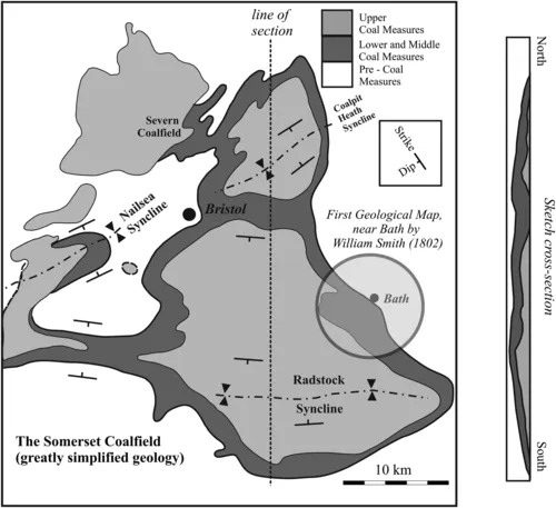
Pragmatically, coal miners in Somerset, SW England (like miners elsewhere in Europe) had already recognized that within a specific region, certain strata always occur in the same order in a given coalfield (Figure 1.2) and they may be correlated from one area to another (Figure 1.3). Moreover, in Somerset, miners knew that certain fossils characterized certain strata. This ordering was not unique to one mine but occurred throughout an extensive coalfield. Smith first comprehended the combined scientific significance of these facts and their practical value. Although he had no formal education beyond grammar school, Smith was a keen observer and had a natural instinct for the scientific metho...
Table of contents
- Cover image
- Title page
- Table of Contents
- Copyright
- Foreword
- Acknowledgments
- Chapter 1. Geological Maps and Some Basic Terminology
- Chapter 2. Relative Ages
- Chapter 3. Absolute Ages
- Chapter 4. Age Relationships from Map View
- Chapter 5. Layered (Stratified) Rocks and Topography
- Chapter 6. Strata and Plane-Dipping Features
- Chapter 7. Dips, Thicknesses Structure Contours and Maps
- Chapter 8. Unconformities
- Chapter 9. Faults
- Chapter 10. Folds
- Appendix 1
- Appendix 2. Final Project Possible after Completion of Studying This Book
- Index
Frequently asked questions
Yes, you can cancel anytime from the Subscription tab in your account settings on the Perlego website. Your subscription will stay active until the end of your current billing period. Learn how to cancel your subscription
No, books cannot be downloaded as external files, such as PDFs, for use outside of Perlego. However, you can download books within the Perlego app for offline reading on mobile or tablet. Learn how to download books offline
Perlego offers two plans: Essential and Complete
- Essential is ideal for learners and professionals who enjoy exploring a wide range of subjects. Access the Essential Library with 800,000+ trusted titles and best-sellers across business, personal growth, and the humanities. Includes unlimited reading time and Standard Read Aloud voice.
- Complete: Perfect for advanced learners and researchers needing full, unrestricted access. Unlock 1.5M+ books across hundreds of subjects, including academic and specialized titles. The Complete Plan also includes advanced features like Premium Read Aloud and Research Assistant.
We are an online textbook subscription service, where you can get access to an entire online library for less than the price of a single book per month. With over 1.5 million books across 990+ topics, we’ve got you covered! Learn about our mission
Look out for the read-aloud symbol on your next book to see if you can listen to it. The read-aloud tool reads text aloud for you, highlighting the text as it is being read. You can pause it, speed it up and slow it down. Learn more about Read Aloud
Yes! You can use the Perlego app on both iOS and Android devices to read anytime, anywhere — even offline. Perfect for commutes or when you’re on the go.
Please note we cannot support devices running on iOS 13 and Android 7 or earlier. Learn more about using the app
Please note we cannot support devices running on iOS 13 and Android 7 or earlier. Learn more about using the app
Yes, you can access Understanding Geology Through Maps by Graham Borradaile in PDF and/or ePUB format, as well as other popular books in Technology & Engineering & Geology & Earth Sciences. We have over 1.5 million books available in our catalogue for you to explore.