- 522 pages
- English
- ePUB (mobile friendly)
- Available on iOS & Android
eBook - ePub
Seismic Stratigraphy, Basin Analysis and Reservoir Characterisation
About this book
The interest in seismic stratigraphic techniques to interpret reflection datasets is well established. The advent of sophisticated subsurface reservoir studies and 4D monitoring, for optimising the hydrocarbon production in existing fields, does demonstrate the importance of the 3D seismic methodology. The added value of reflection seismics to the petroleum industry has clearly been proven over the last decades. Seismic profiles and 3D cubes form a vast and robust data source to unravel the structure of the subsurface. It gets nowadays exploited in ever greater detail. Larger offsets and velocity anisotropy effects give for instance access to more details on reservoir flow properties like fracture density, porosity and permeability distribution, Elastic inversion and modelling may tell something about the change in petrophysical parameters. Seismic investigations provide a vital tool for the delineation of subtle hydrocarbon traps. They are the basis for understanding the regional basin framework and the stratigraphic subdivision. Seismic stratigraphy combines two very different scales of observation: the seismic and well-control. The systematic approach applied in seismic stratigraphy explains why many workers are using the principles to evaluate their seismic observations. The here presented modern geophysical techniques allow more accurate prediction of the changes in subsurface geology. Dynamics of sedimentary environments are discussed with its relation to global controling factors and a link is made to high-resolution sequence stratigraphy. 'Seismic Stratigraphy Basin Analysis and Reservoir Characterisation' summarizes basic seismic interpretation techniques and demonstrates the benefits of intergrated reservoir studies for hydrocarbon exploration. Topics are presented from a practical point of view and are supported by well-illustrated case histories. The reader (student as well as professional geophysicists, geologists and reservoir engineers) is taken from a basic level to more advanced study techniques.* Overview reflection seismic methods and its limitations.* Link between basic seismic stratigraphic principles and high resolution sequence stratigraphy.* Description of various techniques for seismic reservoir characterization and synthetic modelling.* Overview nversion techniques, AVO and seismic attributes analysis.
Trusted by 375,005 students
Access to over 1.5 million titles for a fair monthly price.
Study more efficiently using our study tools.
Information
Topic
Physical SciencesSubtopic
Geology & Earth SciencesChapter 1
Introduction
The interest in seismic stratigraphic techniques to interpret seismic datasets is expanding continuously. The advent of sophisticated subsurface reservoir studies and 4D monitoring, for optimising the hydrocarbon production in existing fields, do demonstrate the importance of the 3D seismic methodology. The added value of reflection seismics has clearly been proven in the last decades and it was especially beneficial on the petroleum development side. Seismic reflection profiles form a vast and solid data source of information on the structure of the subsurface. The seismic dataset gets nowadays explored in ever greater detail. These kind of investigations provide a vital tool for delineation of subtle hydrocarbon traps and are essential in regional basin analysis. The big advantage of seismic stratigraphy in basin studies lies in the fact that the methodology combines two very different scales of observation: the seismic and well-control approach. This explains why many workers are using seismic stratigraphic principles to evaluate their seismic observations (e.g. Payton et al. 1977, Brown and Fisher 1976 and 1980, Rochow 1981, Halbouty 1982, Berg and Woolverton 1985, Bally 1987, Wilgus et al. 1988, Ziegler 1990, Armentrout and Perkins 1991, Cramez et al. 1993, Den Hartog Jager et al. 1993, Henri 1994, Brown 1999, Cosentino 2001, Biju-Duval 2002, Davies et al. 2004).
Conventional stratigraphy deals with data obtained from studies of outcrops, rock samples and petrophysical measurements from boreholes (Rawson et al. 2001). It allows determination of lithofacies, environment of deposition and assignment of ages to these discrete observation points. The data between these calibration points is normally interpolated, which is often done in a rather crude way (Figure 1.1). The information, stemming from various study techniques, are not always straightforwardly in line with each other and this may lead to erroneous conclusions on the nature of the changes in the subsurface geology (Veeken 1997).
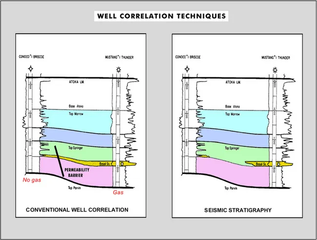
Figure 1.1 Two scenarios for interpolation between well calibration points. The gas sand is only present in the well at the right. Seismic stratigraphic interpretation techniques are needed to document the pinch-out of sands, instead of introducing a hypothetical permeability barrier in he model (modified after Clement 1977, reprint from AAPG whose permission is required for further use).
In seismic stratigraphy, however, reflection seismics provides an elegant way to carry out interpolation procedures. It equally allows extrapolation into less well-explored areas. An important aspect of seismic interpretation is the analogy or example function formed by calibrated datasets. It provides a means to make predictions on the geological development in unknown basins, where well control is lacking or very scarce. This analogy approach enables extrapolation of the geological data/working models into virgin areas in a more sound manner than was previously possible.
The reflection seismic method creates a geophysically sampled picture of the subsurface, which has to be interpreted in a geologically meaningful manner. The basics of the sound reflection method are rather old. An early application has been illustrated by Lawyer (2004) who recently published an interesting extract from ‘The History Book 4’ written by Herodotus around 450 BC (Figure 1.2). It shows that human beings did apply unconventional techniques to prolong their survival if necessary and they were clever enough to realise the potential of the echoed return signal of sound waves.
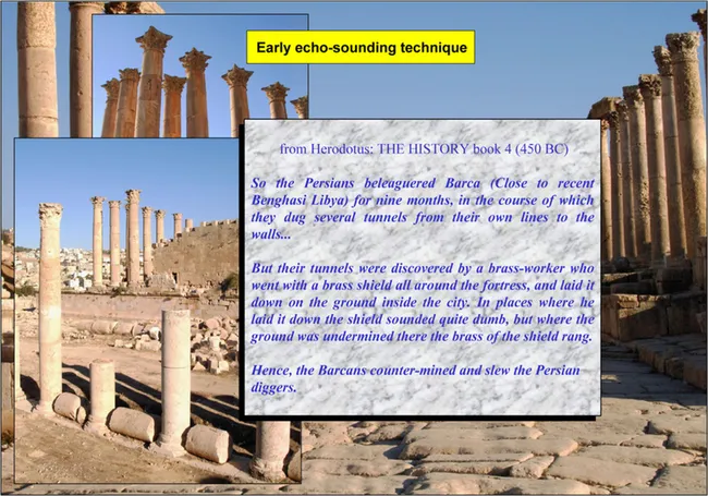
Figure 1.2 Extract from the book ‘Histories’ written by Herodotus of Halicarnassus around 450 BC, illustrating an early application of the principles behind the acoustic echo-sounding investigation technique (modified after Lawyer 2004).
Seismic information is unique and it is fundamental for assessing the amount of geological change between well calibration points (Figure 1.3). Moreover, the reflection seismic method represents a convenient remote sensing technique, whereby the object under investigation is examined without being destroyed.
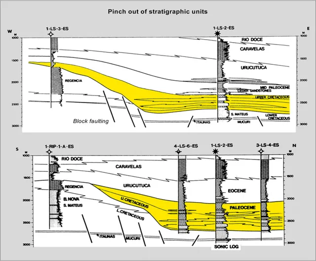
Figure 1.3 Stratigraphic pinch-out of complete stratigraphic time units. Seismic observations are crucial to establish a basin wide frame and a reliable well correlation (modified after Lindseth and Beraldo 1985, reprint from AAPG whose permission is required for further use).
The scope of seismic stratigraphic studies is ranging from large-scale basin analysis to detailed reservoir mapping, with as ultimate goal the ‘Lateral Prediction’ of the reservoir porefill (reservoir characterisation). A multi-disciplinary solution to the given problems necessitates good communication whereby the jargon needs to be adapted to the audience (cf Berkhout 2005). It can be easily appreciated that seismic analysis is extremely beneficial for the exploitation of energy resources like hydrocarbons, but also other domains are of potential interest (e.g. mining industry, archaeology, environmental management, etc.).
The focus in this textbook will be on the regional aspects of seismic stratigraphic interpretation. ‘Lateral Prediction’ topics are presented in a more general way. The main objectives from a petroleum explorer’s point of view are:
– To gain an understanding of the geological evolution of sedimentary basins and establish their litho- and chronostratigraphic framework; this is even achieved when only limited amount of calibration data is available.
– To pinpoint source rock and reservoir/seal pairs and define possible hydrocarbon plays. This includes the delineation of structural/stratigraphic traps and analysis of possible DHI’s (Direct Hydrocarbon Indicators).
When all these goals are achieved and the results of the seismic stratigraphic analysis are properly documented, then the geoscientist is in a position to further evaluate the hydrocarbon potential of the area under investigation. For this purpose several issues need to be addressed (Figure 1.4). The mapped structures/traps are assessed in terms of volumetrics and recoverable reserves. Reservoir modelling improves the understanding of the seismic response. Geostatistics and simulations give a better comprehension of the risk and amount of uncertainty related to the expected fluid flow behaviour in a reservoir. Thereafter a ranking of the various prospects is usually prepared, taking fully into account the economics of the projects. Finally a detailed field development plan (FDP) is devised. This document contains basic systematic guidelines on how to recuperate the hydrocarbons. New technologies increase the reliability of the subsurface predictions made by the geoscientists. Advanced 3D visualisation, neural network classification, multi-attribute analysis and 4D/4C monitoring constitute powerful routine evaluation tools, that will play an even more prominent role in the near future.
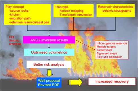
Figure 1.4 Delineation of possible hydrocarbon traps is often supported by seismic attribute analysis. The AVO and inversion processing give access to additional seismic information, that leads to improved volumetrics and better risk analysis. Ultimately it will result in more optimised development plans (FDP) and the HC recovery rate is in many cases augmented considerably, as will be shown in the chapters below.
The first thing to do, in order to meet the above outlined targets of seismic stratigraphic studies, is to extract all relevant information from the available outcrop/borehole/geophysical data. The full dataset needs to be incorporated in the geological interpretation. It speaks for itself that it is best to do the data integration in an early phase of each study. Obviously it is crucial to discriminate between genuine seismic events and artefacts introduced by the applied acquisition/processing parameters. Quality control is a hot issue that should never be neglected during the processing and interpretation phases of a project (Da Silva et al. 2004).
Below, first the physical restrictions imposed by the seismic method are examined. Afterwards the basic seismic stratigraphic principles, with the reflection termination mapping and proper well calibration, are presented. Subsequently the various depositional en...
Table of contents
- Cover image
- Title page
- Table of Contents
- Handbook of Geophysical Exploration: Seismic Exploration
- Front Matter
- Copyright page
- Sponsorship
- About the Author
- Preface
- Chapter 1: IntroductionIntroduction
- Chapter 2: The Seismic Reflection Method and Some of Its ConstraintsThe Seismic Reflection Method and Some of Its Constraints
- Chapter 3: Seismic Stratigraphic TechniquesSeismic Stratigraphic Techniques
- Chapter 4: Dynamics of Basinwide Sedimentation Patterns and Sealevel ChangesDynamics of Basinwide Sedimentation Patterns and Sealevel Changes
- Chapter 5: Hydrocarbon HabitatHydrocarbon Habitat
- Chapter 6: Seismic Reservoir CharacterisationSeismic Reservoir Characterisation
- Chapter 7: Volumetrics and Prospect EvaluationVolumetrics and Prospect Evaluation
- Chapter 8: Concluding RemarksConcluding Remarks
- References
- Subject Index
Frequently asked questions
Yes, you can cancel anytime from the Subscription tab in your account settings on the Perlego website. Your subscription will stay active until the end of your current billing period. Learn how to cancel your subscription
No, books cannot be downloaded as external files, such as PDFs, for use outside of Perlego. However, you can download books within the Perlego app for offline reading on mobile or tablet. Learn how to download books offline
Perlego offers two plans: Essential and Complete
- Essential is ideal for learners and professionals who enjoy exploring a wide range of subjects. Access the Essential Library with 800,000+ trusted titles and best-sellers across business, personal growth, and the humanities. Includes unlimited reading time and Standard Read Aloud voice.
- Complete: Perfect for advanced learners and researchers needing full, unrestricted access. Unlock 1.5M+ books across hundreds of subjects, including academic and specialized titles. The Complete Plan also includes advanced features like Premium Read Aloud and Research Assistant.
We are an online textbook subscription service, where you can get access to an entire online library for less than the price of a single book per month. With over 1.5 million books across 990+ topics, we’ve got you covered! Learn about our mission
Look out for the read-aloud symbol on your next book to see if you can listen to it. The read-aloud tool reads text aloud for you, highlighting the text as it is being read. You can pause it, speed it up and slow it down. Learn more about Read Aloud
Yes! You can use the Perlego app on both iOS and Android devices to read anytime, anywhere — even offline. Perfect for commutes or when you’re on the go.
Please note we cannot support devices running on iOS 13 and Android 7 or earlier. Learn more about using the app
Please note we cannot support devices running on iOS 13 and Android 7 or earlier. Learn more about using the app
Yes, you can access Seismic Stratigraphy, Basin Analysis and Reservoir Characterisation by P.C.H. Veeken in PDF and/or ePUB format, as well as other popular books in Physical Sciences & Geology & Earth Sciences. We have over 1.5 million books available in our catalogue for you to explore.