eBook - ePub
Geological Objects and Structures in 3D
Observation, Interpretation and Building of 3D Models
- 160 pages
- English
- ePUB (mobile friendly)
- Available on iOS & Android
eBook - ePub
Geological Objects and Structures in 3D
Observation, Interpretation and Building of 3D Models
About this book
Geologists must be able to "read" a geological map. That means interpreting the vertical dimension through the 2D view represented on the map and at different scales. The main objective of this book is to help students during this difficult learning process. Based on an abundant iconography (field photos, maps, cross-sections) and on basics in mathematics and mechanics, the book dissects the geometry of emblematic geological structures and objects in order to build 3 D models, printable in 3D. The book is dedicated to structural geology with a particular emphasis on kinematics of faulting and folding and on salt tectonics (chapters III, IV and V). The origin of continental great unconformities and oceanic break-up unconformities is also discussed (chapter II).
The audience of the book is broad and includes (under)graduate students in Earth Sciences, professors of Natural Sciences, and professional or amateur geologists.
Trusted by 375,005 students
Access to over 1.5 million titles for a fair monthly price.
Study more efficiently using our study tools.
Information
Chapter 1
Geology, a story of layers
In cartography, the insoluble problem of projections arises from the impossibility of representing on a plane, without deforming it, a curved surface.
(J. Gracq, 1986)
1.1 The globe and the various layers that make it up
The upper part of the globe, the so-called lithosphere, is formed by a series of layers (Fig. 1.1). Thus, we distinguish from bottom to top:
- the upper (lithospheric) mantle consisting of peridotites; and
- the continental or oceanic crust.
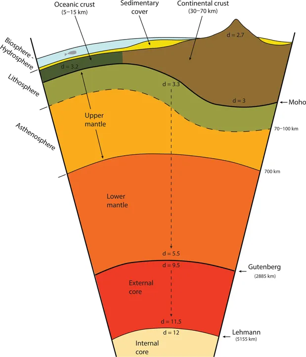
Figure 1.1 The different layers of the earth system.
The continental crust, of general granitic composition, consists of two layers (three for some authors) with different mechanical behaviors. The upper crust exhibits a rather brittle behavior while the lower crust holds ductile behavior. As for the oceanic crust, it is also formed of layers that are of different natures: peridotite below, then gabbro and finally basalt at the top. The deeper layers (lower mantle and core) are inaccessible to direct observation. We will not talk about them in this book, but they are recalled for the record in Figure 1.1.
At the top of the edifice, the sedimentary cover is a stack of layers (in the sedimentary domain, we also speak of strata) of varied nature (limestone, marl, clay, sand, sandstone, salt etc.) and contrasting mechanical behavior. In this book, we are interested primarily, but not exclusively, in this very superior part of the system that is at the interface with the biosphere.
These layers that form the sedimentary basins can be folded and/or faulted. They can also be integrated into the mountain ranges, with in this case much larger deformations. When the mountain ranges are young or even still active, considerable reliefs (Andes and Himalayas) mark them. When these chains are old, they are integrated into the continental crust itself and form what is called the “basement.” The basement is separated from the sedimentary cover by a major discontinuity called unconformity (for developments on the concepts of basement and sedimentary cover, see Chapter 2). The basement can be at the surface in continental areas without sedimentary cover. The areas where the basement is exposed represents about 30% of the surface of the continental shelf. They are called “old massif,” “shield” or, if the basement is very old, “craton.” Basement and cover have, in general, very different mechanical behaviors. As a result, the basement-cover interface is frequently the site of significant decoupling generating different deformation styles on both sides.
1.2 Strike and dip of a layer
The dip of a geological layer is the angle between a horizontal plane and the plane of the layer (β in Fig. 1.2), the intersection between the two planes being the strike or azimuth (α). The measurement of a dip obviously does not concern only the sedimentary layers; we can measure the dip of any plane having a geological significance: fault plane, the wall of a vein, the contact with an intrusion etc. A dip is measured in a vertical plane passing through the line of greatest slope of the plane to be measured. To be perfectly located in geographical space, we must also know the strike (α), that is to say, the angle measured in the horizontal plane between a horizontal line contained in the geological layer and the geographical north (Fig. 1.2).
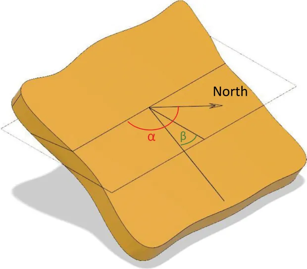
Figure 1.2 Notion of dip of a layer (see explanations in the text).
In practice, there are two methods for measuring the dip of a layer in the field. The first one, called “the French method,” consists in measuring initially the strike of the horizontal plane (α in Fig. 1.2). This angle α is measured between 0° and 180° in the east dial of the compass. The plane is written in the following manner N x° E (0 ≤ x ≤ 180), meaning: the horizontal has an azimuth of x° measured in the east dial of the compass. Measuring in this dial is a pure convention. The dip is then measured (0 ≤ β ≤ 90) using a clinometer. Finally, it is necessary to indicate the direction of the dip. There remains indeed an indeterminacy because, for a given strike and dip, there are two directions of dip possible. Thus, the final data will be written, for example, N 45° E 60° SW, meaning: an azimuth plane 45° E and a dip 60° to the SW. The so-called “English method” is, let us admit it, simpler and more effective. It consists in giving the angular value of the dip (0 ≤ β ≤ 90) then its direction, thanks to a single measurement between 0° and 360°. The final data will therefore be written for the previous example: 60° N 135°. If the dip is in the other direction, using the “French method” N 45 E 60° NE, then the data would be written using the “English method”: 60° N 225°.
The dip of a layer is measured in the plane containing the line of greatest slope. This can and should be verified when you have access to 3D geometry. Where we have access only to a section (2D by definition), which is frequently the case, we do not know, a priori, if we are dealing with a “real dip” (that is to say, measured in the plane containing the line of greatest slope) or with an “apparent dip” (that is, measured in another vertical plane). The apparent dip is necessarily lower than the actual dip. Finally, if the measurement plane contains the horizontal of the place, the apparent dip will be zero.
1.3 Geometric relationships between dip and topography using the three points method
In the general case, the geologist derives their rationale from a geological map. On this map, the geological layers, represented by colors corresponding to geological ages (see Stratigraphic chart), interfere with the topography represented by contour lines. The map gives us direct access to the thickness of a layer only in the particular case where this layer is vertical (Fig. 1.3).
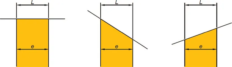
Figure 1.3 Series of three sections showing that for a vertical ...
Table of contents
- Cover
- Half Title
- Title Page
- Copyright Page
- Contents
- Preface
- Foreword
- 1 Geology, a story of layers
- 2 When strata cross and overlie each other: the concept of unconformity
- 3 When strata fracture: faults
- 4 When strata fold without breaking too much: detachment folds
- 5 When folds and faults interact: fault-related folds and fold-and-thrust belts
- 6 When the salt plays the major role: the effects of salt activity and the concept of salt tectonics
- Appendix
- Glossary
- Stratigraphic chart
- Bibliography
- Index
Frequently asked questions
Yes, you can cancel anytime from the Subscription tab in your account settings on the Perlego website. Your subscription will stay active until the end of your current billing period. Learn how to cancel your subscription
No, books cannot be downloaded as external files, such as PDFs, for use outside of Perlego. However, you can download books within the Perlego app for offline reading on mobile or tablet. Learn how to download books offline
Perlego offers two plans: Essential and Complete
- Essential is ideal for learners and professionals who enjoy exploring a wide range of subjects. Access the Essential Library with 800,000+ trusted titles and best-sellers across business, personal growth, and the humanities. Includes unlimited reading time and Standard Read Aloud voice.
- Complete: Perfect for advanced learners and researchers needing full, unrestricted access. Unlock 1.5M+ books across hundreds of subjects, including academic and specialized titles. The Complete Plan also includes advanced features like Premium Read Aloud and Research Assistant.
We are an online textbook subscription service, where you can get access to an entire online library for less than the price of a single book per month. With over 1.5 million books across 990+ topics, we’ve got you covered! Learn about our mission
Look out for the read-aloud symbol on your next book to see if you can listen to it. The read-aloud tool reads text aloud for you, highlighting the text as it is being read. You can pause it, speed it up and slow it down. Learn more about Read Aloud
Yes! You can use the Perlego app on both iOS and Android devices to read anytime, anywhere — even offline. Perfect for commutes or when you’re on the go.
Please note we cannot support devices running on iOS 13 and Android 7 or earlier. Learn more about using the app
Please note we cannot support devices running on iOS 13 and Android 7 or earlier. Learn more about using the app
Yes, you can access Geological Objects and Structures in 3D by Dominique Frizon de Lamotte,Pascale Leturmy,Pauline Souloumiac,Adrien Frizon de Lamotte in PDF and/or ePUB format, as well as other popular books in Physical Sciences & Geology & Earth Sciences. We have over 1.5 million books available in our catalogue for you to explore.