eBook - ePub
Weather Analysis and Forecasting
Applying Satellite Water Vapor Imagery and Potential Vorticity Analysis
- 360 pages
- English
- ePUB (mobile friendly)
- Available on iOS & Android
eBook - ePub
Weather Analysis and Forecasting
Applying Satellite Water Vapor Imagery and Potential Vorticity Analysis
About this book
Weather Analysis and Forecasting: Applying Satellite Water Vapor Imagery and Potential Vorticity Analysis, Second Edition, is a step-by-step essential training manual for forecasters in meteorological services worldwide, and a valuable text for graduate students in atmospheric physics and satellite meteorology. In this practical guide, P. Santurette, C.G. Georgiev, and K. Maynard show how to interpret water vapor patterns in terms of dynamical processes in the atmosphere and their relation to diagnostics available from numerical weather prediction models. In particular, they concentrate on the close relationship between satellite imagery and the potential vorticity fields in the upper troposphere and lower stratosphere. These applications are illustrated with color images based on real meteorological situations over mid-latitudes, subtropical and tropical areas.
- Presents interpretation of the water vapor channels 6.2 and 7.3µm as well as advances based on satellite data to improve understanding of atmospheric thermodynamics
- Improves by new schemes the understanding of upper-level dynamics, midlatitudes cyclogenesis and fronts over various geographical areas
- Provides analysis of deep convective phenomena to better understand the development of strong thunderstorms and to improve forecasting of severe convective events
- Includes efficient operational forecasting methods for interpretation of data from NWP models
- Offers information on satellite water vapor images and potential vorticity fields to analyse and forecast convective phenomena and thunderstorms
Frequently asked questions
Yes, you can cancel anytime from the Subscription tab in your account settings on the Perlego website. Your subscription will stay active until the end of your current billing period. Learn how to cancel your subscription.
No, books cannot be downloaded as external files, such as PDFs, for use outside of Perlego. However, you can download books within the Perlego app for offline reading on mobile or tablet. Learn more here.
Perlego offers two plans: Essential and Complete
- Essential is ideal for learners and professionals who enjoy exploring a wide range of subjects. Access the Essential Library with 800,000+ trusted titles and best-sellers across business, personal growth, and the humanities. Includes unlimited reading time and Standard Read Aloud voice.
- Complete: Perfect for advanced learners and researchers needing full, unrestricted access. Unlock 1.4M+ books across hundreds of subjects, including academic and specialized titles. The Complete Plan also includes advanced features like Premium Read Aloud and Research Assistant.
We are an online textbook subscription service, where you can get access to an entire online library for less than the price of a single book per month. With over 1 million books across 1000+ topics, we’ve got you covered! Learn more here.
Look out for the read-aloud symbol on your next book to see if you can listen to it. The read-aloud tool reads text aloud for you, highlighting the text as it is being read. You can pause it, speed it up and slow it down. Learn more here.
Yes! You can use the Perlego app on both iOS or Android devices to read anytime, anywhere — even offline. Perfect for commutes or when you’re on the go.
Please note we cannot support devices running on iOS 13 and Android 7 or earlier. Learn more about using the app.
Please note we cannot support devices running on iOS 13 and Android 7 or earlier. Learn more about using the app.
Yes, you can access Weather Analysis and Forecasting by Christo Georgiev,Patrick Santurette,Karine Maynard in PDF and/or ePUB format, as well as other popular books in Physical Sciences & Meteorology & Climatology. We have over one million books available in our catalogue for you to explore.
Information
Part 1
Fundamentals
Chapter 1
A Dynamical View of Synoptic Development
Abstract
The aim of this chapter is to present basic points of the development theory and relevant concepts involving interactions and feedback between dynamic structures at different levels in the atmosphere, and their evolution, that can be of practical benefit in weather forecasting. The considerations are based on thinking in terms of potential vorticity (PV) as a powerful way of looking at the development/movement of features in the flow and understanding unfolding atmospheric dynamics. The surface of transition between low tropospheric values and high stratospheric values of PV is considered as dynamical tropopause. Anomalies in the dynamical tropopause heights are associated with meaningful dynamical structures: their interaction with upper-level jets, their remote influence in modifying the fields of temperature and vertical motions as well as inducing a cyclonic circulation are discussed. Analysis of a real-atmosphere structure as an example of using this approach to understand synoptic development is presented.
Keywords
Dynamical tropopause; Dynamical tropopause anomaly; Jet streak; Potential vorticity; Synoptic development; Upper-troposphere dynamics1.1. Vorticity and Potential Vorticity
Some meteorological parameters are more effective than others for studying the appearance and evolution of dynamical structures at synoptic scale. The conservative parameters—those that remain unchanged when one follows a particle of fluid in motion—are best suited to detect and monitor the structures that play various key roles in a meteorological scenario. With the assumption of adiabatic motions, the potential temperature θ and wet-bulb potential temperature θw are thermodynamic tracers for the air particles. They allow us to compare the thermal properties of air particles without taking into account the effects due to thermal advection and pressure changes. However, they only represent a few of the important properties that determine the evolution of the atmosphere. To better understand the observed phenomena, dynamical properties must also be taken into account.
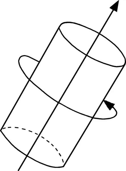
In midlatitudes, at synoptic scale, the important dynamical properties are those related to the rotation of air particles. This rotation is linked both to the motion of Earth and to the rotation component of the wind. The rotation of fluid particles is described by the variable vorticity. Vorticity is a measure of the local rotation or spin of the atmosphere: It is the key variable of synoptic dynamics. As illustrated in Fig. 1.1, the vorticity vector gives the direction of the spin axis, and its magnitude is proportional to the local angular velocity about this axis. The fluid particles turn around their vorticity vector, and the absolute vorticity is equal to the relative spin around a local cylinder plus the rotation of the coordinate system.
To interpret a process in terms of quasi-geostrophic theory, only the vertical component of the vorticity equation is explicitly considered. The vertical component of absolute vorticity is ζ = f + ξ, where f is the Coriolis parameter and the relative vorticity is given by

Figure 1.1 A vorticity vector and the local rotation in the atmosphere indicated by the circulation around a cylinder of air oriented along the vorticity vector. Adapted from Hoskins, B., 1997. A potential vorticity view of synoptic development. Meteorol. Appl. 4, 325–334.

It is also supposed that, at synoptic scale, Earth's rotation dominates (ie, ζ ≅ f), in which case the relative vorticity equation contains only stretching and shrinking of this basic rotation (Hoskins, 1997). Two examples are presented in Fig. 1.2. Along the zero vertical motion at the ground, we can make the following observations:
• Tropospheric ascent implies stretching and creation of absolute vorticity greater than f, that is, cyclonic relative vorticity, in the lower troposphere.
• Similarly, tropospheric descent implies shrinking and creation of relative anticyclonic vorticity in the lower troposphere.
• If the initial relative vorticity is zero, the two situations in Fig. 1.2A and B correspond to cyclonic and anticyclonic surface development.
Consistent with this discussion, synoptic development can be viewed in terms of vertical velocity (derived in the framework of the quasi-geostrophic theory) associated with the evolution of vorticity in the middle and upper troposphere. Pedder (1997) shows that such a quasi-geostrophic approach can be used for the purposes of subjective analysis to diagnose the vertical circulation associated with a large-scale distribution of pressure and temperature.

Figure 1.2 Tropospheric (A) ascent and (B) descent that leads to respectively (A) stretching and (B) shrinking of vorticity associated with (A) increase and (B) decrease of vorticity and circulation. Adapted from Hoskins, B., 1997. A potential vorticity view of synoptic development. Meteorol. Appl. 4, 325–334.
Together with quasi-geostrophic theory, the so-called potential vorticity (PV) thinking has proven to be quite useful to study synoptic development in midlatitudes (for theoretical background and references see Hoskins et al., 1985, which contains an exhaustive review of the use of PV)....
Table of contents
- Cover image
- Title page
- Table of Contents
- Copyright
- Preface
- Acknowledgments
- Introduction
- Part 1. Fundamentals
- Part 2. Practical Use of Water Vapor Imagery and Thermodynamic Fields
- Conclusion
- Appendix A. Radiation Measurements in Water Vapor Absorption Band
- Appendix B. Potential Vorticity Modification Technique and Potential Vorticity Inversion to Correct the Initial State of the Numerical Model
- References
- Glossary
- Index