Fred Aminzadeh and Shivaji N. Dasgupta
1.1 Purpose of the Book
This volume focuses on the application of geophysics to petroleum engineering disciplines. The objective is to introduce petroleum engineers to application of geophysical methods so that they can better communicate their needs and appreciate the full benefits derived from the application of geophysics. We hope this book will help engineers understand the integration of geophysical, geological, and petrophysical concepts and their applications. Understanding of the reservoir rock and fluid properties and their influences on production and injection efficiency is imperative for optimum asset management. Geophysical data integrated with well data can address this requirement. The chapters define the fundamentals of geophysical techniques, their physical basis, and their applications. They also describe the limitations of geophysical tools and the potential pitfalls in their misuse. Many real life examples illustrate the integration of geophysical data with other data types for predicting and describing reservoir rock and fluid properties.
We emphasize that we have attempted to cover the most important topics that we believe will be of value to practicing engineers and petroleum engineering students who want to advance their understanding of geophysical technologies. To accomplish this task, certain compromises have had to be made. We provide, for instance, very little coverage to seismic data processing, which is important but may not be as crucial for a working engineer. Yilmaz (2001) is an excellent book addressing seismic processing and imaging issues. Lines and Newrick (2004) and Liner (2004) also cover processing and other geophysical concepts in depth. Many theoretical details on the wave equation the basis of most geophysical techniques, are also treated rigorously in these and many other books.
Instead of dwelling on technical details with theories and equations, we have used a large number of examples with figures from various sources and case histories to introduce different subjects. The idea is to convey useful information and provide examples of real life applications for those who may not want to get into in-depth studies on a given subject. The references, case histories, and examples we have included make no claim to be the most recent or most important ones but they are those we happen to know about. Given the wide area we have had to cover, we acknowledge possible omission of many important ones.
1.2 Geoscience Disciplines
Geology is an observational science. It involves the study of the earth by direct measurements of rock properties, either from surface exposures (outcrops) or from boreholes, tunnels, and mines. Geological techniques allow deduction of the earth’s structure, rock texture, composition, and history by the analysis of these observations.
Geophysics, on the other hand, applies the principles of physics to the study of the earth, for deducing physical features of the earth's surface and its internal structure. Geophysics involves the study of those parts of the earth hidden from direct view, by measuring their physical properties, with appropriate instruments on or above the surface of the earth, remotely from the measurement targets. Some geophysical tools measure physical responses of the ambient fields of rocks in a passive mode, for example, gravitational, magnetic, and radioactive. Other geophysical tools such as seismic, gravitational, electrical, and electromagnetic methods rely on either some active source of energy that transmits through the subsurface rocks or passive sources of energy (such as movement of the earth) or fracturing caused by stress, in the case of microearthquake data. The signal from the source of energy (either passive or active) is altered by the properties of rocks and this response is measured.
Virtually all of what we know about the earth below the limited depths to which boreholes, tunnels, and mines have penetrated, has been derived from geophysical observations. The properties of the solid inner core, the liquid outer core, the lower mantle and upper mantle, and the crust have all been deduced from the propagation of seismic waves from earthquakes.
Petrophysics deals with the physical and chemical properties of the earth’s rocks and fluids. Petrophysicists provide the physical parameters upon which geophysical inversions are based and the detailed reservoir volumetric and flow properties upon which petroleum reserves are based. While geophysicists deal with indirect measurements on very large scales, which infer gross (heterogeneous) lithological units and structures, petrophysicists work on a much more detailed scale, looking at the various heterogeneities that geophysicists homogenize into gross structural units.
1.2.1 Geosciences in Petroleum Engineering
Petroleum engineers require some working knowledge of geology and geophysics during the different stages of development of oil and gas fields. This process begins with exploration, discovery, and appraisal drilling through reservoir development, production, and enhanced recovery, as well as the field’s eventual depletion and abandonment. Team efforts by geoscientists and engineers focus on maximizing economic recovery of hydrocarbons throughout the life of a field. Integration of geophysical data with geologic data and engineering measurements improves our understanding of the reservoir, reduces uncertainties, and mitigates the risks. The improved knowledge of the reservoir impacts the life of the field, its economics, and the ultimate recoverable (EUR) volume of oil and gas from the field resource base. Some understanding of the physical behavior of oil, water, and gas within porous rock at reservoir pressure and temperature and their impact on the characteristics of the geophysical measurements are ascertained.
Reservoir, drilling, and production engineers must be able to understand the information provided by geophysicists, geologists, and petrophysicists so as to be able to properly utilize it. This is particularly important because of the multidisciplinary nature of the challenges faced in oil and gas exploration and production. The need to integrate the data and the disciplines is important. As engineers become more familiar with geophysical techniques, there will be expansion in applications of geophysical techniques in reservoir engineering practices. Geophysical tools are continuously evolving in order to address the present requirements and to be prepared for future challenges.
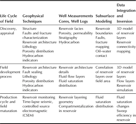
During a reservoir’s life cycle from discovery and development to production and field maturation, the needs for reservoir description change continuously. Table 1.1 shows the reservoir analysis by integration during the various stages in the life cycle of a field.
Table 1.1
Reservoir Analysis by Integration of Techniques During Field Production Life
1.3 Geoengineering Concept
Integrated asset management and encouraging geoscientists and engineers to work closely with each other have gained popularity in recent years. Aminzadeh (1996) introduced the concept of geoengineering as the wave of the future. He indicated, “As we approach the next millennium and as our problems become too complex to rely only on one discipline to solve them more effectively, multidisciplinary approaches in the petroleum industry become more of a necessity than professional curiosity. We will be forced to bring down the walls we have built around classical disciplines such as petroleum engineering, geology, geophysics and geochemistry, or at the very least make them more permeable. Our data, methodologies, and approaches to tackle problems will have to cut across various disciplines. As a result, today’s ‘integration,’ which is based on integration of results, will have to give way to a new form of integration, that is, integration of disciplines.”
The geoengineering idea was picked up by many others, most notably Corbett (1997) where he maintained, “There is an ongoing debate (Aminzadeh, 1996) concerning the emergence of a new petroleum discipline – Geoengineering. This has been put forward as a solution to the problems facing the petroleum industry in integrating the disciplines. This contribution to the debate addresses the response of an academic institution to the challenge.” Indeed, Heriot-Watt University in Edinburgh, UK, established the first Geoengineering program, under Dr. Patrick Corbett. Since then, many other universities have adopted the concept in one form or another. Various operating oil companies have followed the same trend and established multidisciplinary asset teams in their organizations.
1.3.1 Petroleum Geophysics
Geophysics is the study of physical responses of rocks under passive or active perturbation. Data from geophysical observations are interpreted to infer geology. Multiple geologic parameters are assessed with the same geophysical data. Geophysics measures changes in physical properties. The interpretations or inferences made from geophysical data are, however, somewhat nonunique. Data interpretation has inherent ambiguity, that is, multiple interpretations can be made from the same data. In addition to signals, the data contains noise. These issues are addressed by increasing data redundancy or sampling the same subsurface multitudes of times and using signal enhancement techniques in processing. The data gathering is usually designed in a uniformly sampled grid. New data are being collected with increasingly finer sampling as computer and electronics technologies are enhanced and hardware is becoming more reliable and cost effective. An example of ambiguity in seismic interpretation—lateral changes in amplitude can be caused by changes in one or more properties and are therefore inherently imprecise. For example, structural features apparent on seismic data could be the result of local anomalies unrelated to the structure or some of the traditional hydrocarbon indicators may be erroneous. Nevertheless, geophysics offers the best hope of obtaining useful data with a wide lateral and vertical coverage.
Geophysical techniques apply the principles of physics to the study of the earth. Data from geophysical tools provide coverage with a spatially continuous high sampling density of 10–25 m and a vertical resolution of the order of 10–20 m. Well data such as cores and well logs provide a vertically high resolution of the order of 0.5 m or better at the well location; however, the distribution of wells is sparse and discontinuous. The detailed spatial coverage from geophysical data is calibrated with analysis of well logs, pressure tests, cores, geologic depositional knowledge, and other information from appraisal wells.
Geophysical data play an important role in developing a gross reservoir model. The reservoir architecture (structure) and the reservoir properties are derived from the analysis and integration of data from various geoscience disciplines. The distributions of the reservoir and nonreservoir rock types and of the reservoir fluids determine the geometry of the model and influence the type of model to be used. Thus, the goal of geophysics is to contribute to the increment in spatial resolution for defining the building blocks of the reservoir.
Most petroleum geophysical tools were originally developed for exploration. They are now, however, being increasingly applied for reservoir development, monitoring, and management, that is, for optimizing fluid production from reservoirs. Reservoir management is a continuous process from field development through enhanced recovery and, eventually, depletion.
The objective of geophysical techniques is to minimize risk and maximize value. Exploration risks change throughout the life of a venture. Geophysics contributes to reservoir characterization, reservoir monitoring, and its management by adding maximum value to improving the production plan and by minimizing the risks of dry hole, blow out, leaving too much oil behind in the pipe, not penetrating the most prolific part of the reservoir, and inefficient recovery, among others.
Geophysics is a risk reduction tool; it reduces exposure to loss. The techniques either add value (resource discovery and improved reservoir management) or prevent loss (drilling hazards or dry holes). The data interpretation is used f...

