About a millennium ago, in Cairo, an unknown author completed a large and richly illustrated book. In the course of thirty-five chapters, this book guided the reader on a journey from the outermost cosmos and planets to Earth and its lands, islands, features, and inhabitants. This treatise, known as The Book of Curiosities, was unknown to modern scholars until a remarkable manuscript copy surfaced in 2000.
Lost Maps of the Caliphs provides the first general overview of The Book of Curiosities and the unique insight it offers into medieval Islamic thought. Opening with an account of the remarkable discovery of the manuscript and its purchase by the Bodleian Library, the authors use The Book of Curiosities to re-evaluate the development of astrology, geography, and cartography in the first four centuries of Islam. Their account assesses the transmission of Late Antique geography to the Islamic world, unearths the logic behind abstract maritime diagrams, and considers the palaces and walls that dominate medieval Islamic plans of towns and ports. Early astronomical maps and drawings demonstrate the medieval understanding of the structure of the cosmos and illustrate the pervasive assumption that almost any visible celestial event had an effect upon life on Earth. Lost Maps of the Caliphs also reconsiders the history of global communication networks at the turn of the previous millennium. It shows the Fatimid Empire, and its capital Cairo, as a global maritime power, with tentacles spanning from the eastern Mediterranean to the Indus Valley and the East African coast.
As Lost Maps of the Caliphs makes clear, not only is The Book of Curiosities one of the greatest achievements of medieval mapmaking, it is also a remarkable contribution to the story of Islamic civilization that opens an unexpected window to the medieval Islamic view of the world.
Trusted by 375,005 students
Access to over 1.5 million titles for a fair monthly price.
A simple telephone call on a quiet autumn afternoon set in train a surprising chain of events that over the next decade disrupted the otherwise routine existence of a number of academics and injected some astonishing surprises into the field of medieval cartography. On the last Friday in September of 2000 the telephone rang, and a specialist in Islamic manuscripts at Christie’s auction house in London asked if I—that is, Emilie Savage-Smith, who will be narrating the following story—had seen their catalogue for an upcoming sale of Islamic manuscripts to be held on the 10th of October. I had not, for I did not routinely follow the art market. I was then asked if I could come into London from Oxford and look at a manuscript that was up for sale on the 10th, for they thought they had “made a mistake.” In response to this extraordinary request, I said that even if they had “made a mistake,” there was nothing anyone could do about it at that point since the catalogue had been published some weeks earlier. Still, this somewhat bizarre request haunted me. As a result, I arranged to go round to the King Street office of Christie’s the following Monday afternoon.
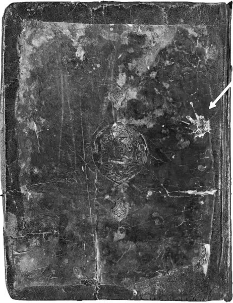
The manuscript that I was shown seemed at first glance a rather scruffy thing, bound in ill-fitting covers. The bird dropping visible on the cover (see fig. 1.1) suggested that its previous owners had stored it in a loft—or even a garden shed—and forgotten about it for some time.
Inside the covers were forty-eight sheets (or folios, as specialists call them) of paper, plus torn strips from two missing leaves. The sheets were larger than a standard page in size (32.4 x 24.5 cm) and made of a sturdy, relatively soft but lightly glossed biscuit-brown paper. The edges had at some point been trimmed for rebinding, with some writing in the margins cut off. The margins were soiled through use, and numerous amateurish repairs had been made on some paper tears. It looked old. My experience cataloguing Islamic medical manuscripts both for the Bodleian Library and for the National Library of Medicine in Bethesda, Maryland, told me that the papers and inks were consistent with an early manuscript.
Fig. 1.1. Front cover of the Book of Curiosities, with bird dropping indicated by arrow. Oxford, Bodleian Library, MS Arab. c. 90.
My attention was transfixed, however, by the large maps and diagrams, as well as drawings of comets and groups of stars, that filled many of these leaves. Having for several years taught a seminar at Oxford’s Museum of the History of Science on cartography in the medieval Islamic world, I recognized that nearly all of the maps or diagrams were unknown in either the published literature or in major manuscript collections. But what were they? I had only a half hour to look at them before I had to leave, knowing that they would be put up for sale in eight days’ time, probably to go into a private collection and not to be seen again by historians for many years, if ever. I was anxiously asked by the specialist at Christie’s, “Are they important?,” and I am afraid I was almost incoherent in my reply. After saying that they probably were, I asked if they had a copy of any of the maps. They did not (except for the three published in their sale catalogue), but they offered me xeroxed copies.
Under ordinary circumstances I would never agree to placing a valuable, ancient manuscript on top a Xerox machine, for fear of the intense light harming the pages and the spine of the volume being damaged. But these were no ordinary circumstances. I asked if photocopies could be made of all the maps and diagrams plus most of the text, and this was immediately done for me in the office. The Xerox machine, of course, only produced a standard-size copy of each page, so the material outside that area was missing from what I was given. Still, it was surely better than nothing. My thinking was that at least scholars would have these black-and-white paper copies to work with, even if the manuscript itself disappeared from view after the sale. Armed with these Xeroxes, I headed for the National Theatre, where I had agreed to meet my husband. The tickets for the play we wished to see were sold out, however, but we had lots to talk about over wine and sandwiches as I showed him the Xeroxes of this remarkable manuscript.
Upon returning to Oxford, the problem to confront was whether there was anything that could be done to assure that the manuscript would end up where scholars could study it. A hasty message of its importance was sent the next day to David Khalili, for whom I had catalogued the scientific and magical manuscripts that form part of the important Nasser D. Khalili Collection of Islamic Art. With Christie’s sale less than a week away, there seemed little else that could be done.
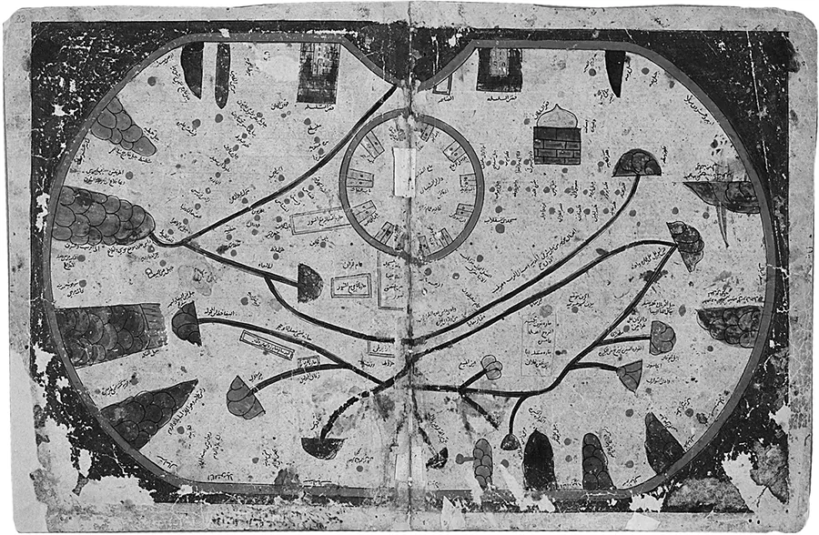
Meanwhile, I took the precious xeroxed copies to the Oriental Institute in Oxford to show colleagues over morning coffee. Jeremy Johns, an acknowledged authority on Sicily and its history, was among the group having coffee, and I showed him the curious large map of an oval island (see fig. 1.2 and plate 7), expecting him to be immediately elated by it. It bore no title, but was part of a chapter titled “The Twelfth Chapter Presenting a Brief Description of the Largest Islands in These Seas.” The “seas” (bihār) in question, I surmised, must be the Mediterranean, and since Sicily is the largest island in that ocean, this, I thought, must surely be Sicily. Jeremy, however, informed me that it could not possibly be Sicily, since we all know that Sicily was always depicted as triangular in shape. A bit deflated, I left a copy of my Xerox of the map with Jeremy and returned to other matters needing my attention. About 10:00 p.m. that evening the telephone rang, and I heard a voice on the other end saying, “It is Sicily!” He had apparently spent the evening deciphering some of the numerous place-names, gate names, and names of markets written on the map in very tiny writing. From that point on, Jeremy was as adamant as I that this curious and old manuscript be available for study by scholars. But how that could be achieved we did not know.
Fig. 1.2. The island of Sicily. Oxford, Bodleian Library, MS Arab. c. 90, fols. 32b–33a, copied ca. 1200.
A week after the sale, I received an unexpected telephone call from Sam Fogg, a highly regarded London dealer in rare (primarily Western) books and manuscripts. It turned out that he was the person who had purchased the manuscript at the auction on October 10th.1 Although he is not an expert in Arabic materials, his professional instincts told him that this was a very important and rare item. The purpose of his call was to ask if I would prepare a write-up, perhaps even a small booklet, on this manuscript in order to sell it following its full description. Somewhat to his surprise, I suspect, I declined to do this, with the argument that the manuscript should not be put up for sale again and risk going into private hands and thereby become unavailable for study. It should be placed in a public collection. The Bodleian Library, I suggested, would be the perfect place.
At the end of the telephone conversation, Sam Fogg said he would call the keeper of the Oriental Collections at the Bodleian and offer the manuscript to the Bodleian for a reasonable price, but warned that if the Bodleian could not raise the funds, then the manuscript would go under the hammer again. Immediately upon hanging up the phone, I rang the newly appointed keeper of the Oriental Collections, Lesley Forbes. She was in fact so recently appointed that we had not yet had occasion to meet and she had no idea who I was. It must have been a most curious call for her to receive. Not only was it from someone she did not know, but the caller told her that she was soon to have a telephone call from a manuscript dealer who would offer the Bodleian—at probably a rather high price—what was possibly one of the most important Arabic manuscripts to come to light in the past hundred years. Why she listened to me and did not dismiss it as a prank, I do not know. She received this call, and the subsequent one from Sam Fogg, at a time of sharp financial restrictions and a pressing need for renovation of book storage areas in the Bodleian, so to anyone else it might have seemed the height of folly to undertake external fundraising for such an acquisition. Yet, if the purpose of the Bodleian is to preserve for posterity the major sources of our intellectual heritage, and to make them available to students and scholars worldwide, then wouldn’t the acquisition of such an important historical and scientific manuscript remind people (and potential donors to the Bodleian) of the library’s primary function and its role as one of the most important repositories of cultural artifacts? Moreover, its acquisition would complement the Bodleian’s already important collection of medieval Islamic cartographic materials. Such thoughts may have been in her mind, for, when the manuscript and its potential importance were drawn to her attention, she agreed to set about trying to raise the funds for its purchase.
Not long thereafter an agreement was drafted whereby Sam Fogg would sell the manuscript to the library for four hundred thousand pounds, giving the Bodleian six months in which to raise the monies. The agreement also included the stipulation that if the manuscript were ever to be shown to be a forgery or a fake, the monies would be returned to the Bodleian—such was the confidence that Sam Fogg had in the legitimacy of this aged manuscript. The price set was well under what he thought to be the true market value. To put this sum in perspective, an Arabic manuscript copy dated 1229 of the Canon of Medicine by Ibn Sīnā (Avicenna to Europeans), who died in 1037, had sold at Sotheby’s in London on October 12th of the same year for well over five hundred thousand pounds, following press stories highlighting its supposed importance. However, there are numerous copies of the Canon preserved today, the text has been fully printed several times, and no new chapters were contained in this copy, nor were there any illustrations. In contrast, “our” manuscript contained a treatise no one knew about, with fourteen completely unique maps plus other diagrams, and much new information on travel and communication between Byzantium and the Islamic world in the eleventh century (though that was not known at this stage). In the event, however, eighteen months rather than six months were required to raise the required funds and to verify various important details regarding the manuscript itself. Throughout this period Sam Fogg generously granted our repeated requests for an extension of time, while allowing the manuscript to be kept at the Bodleian for examination while we tried to raise the funds.
The ensuing eighteen months of fundraising were followed by more than a decade-long project that turned several of our lives upside down. Rather like giving birth to a baby, no one told us ahead of time how much effort and exhaustion was going to be involved.
The first hurdle was to obtain permission from certain committees of the university to undertake the fundraising. And therein we encountered our first major problem: prior to the sale at Christie’s, no one knew that such a treatise existed. There was reluctance on the part of many to believe that the manuscript could possibly be as important as we suggested. How could an eleventh-century treatise containing numerous and large maps and diagrams have been completely unknown to modern scholars? Surely this was impossible. Such was the reaction of many who were puzzled, if not unbelieving, that an entirely unexpected text with massively important new material could still be discovered in the twenty-first century. And particularly in such a well-trodden field as early Arabic geographical writing. As the head of one of the most important committees put it: “If no one has known of this treatise, and no one has published or studied it, then surely it cannot be important.” But the fact that it was “lost” to modern scholars for several hundred years does not mean that it was not important in its day nor that it cannot provide new insights into the intellectual life of the society for which it was composed, as well as its trade and travel.
With necessary committee support for the fundraising denied, it looked as if we would have to terminate our efforts before we even got started. Why not go then, I asked, to the vice chancellor, Sir Colin Lucas, who was a historian, and seek his support for fundraising to obtain this manuscript for the Bodleian? Much to my surprise, I was informed that it would be inappropriate for someone to go over the heads of the official committees to the vice chancellor, in addition to which I was not of sufficient rank to take up the vice chancellor’s time. At this point my American background came into play, and I decided that I would on my own seek the help of the vice chancellor. As it happened, Professor Wadad Qadi of the Department of Near Eastern Languages and Civilizations at the University of Chicago was in town at this time, and since the vice chancellor had been professor of history at the University of Chicago before becoming master of Balliol College and subsequently vice chancellor at Oxford, I asked Professor Qadi...
Table of contents
Cover
Title Page
Copyright Page
Contents
Introduction
Chapter 1 · A Discovery
Chapter 2 · Macrocosm to Microcosm: Reading the Skies and Stars in Fatimid Egypt
Chapter 3 · The Rectangular World Map
Chapter 4 · The Nile, the Mountain of the Moon, and the White Sand Dunes
Chapter 5 · The View from the Sea: Navigation and Representation of Maritime Space
Chapter 6 · Ports, Gates, Palaces: Drawing Fatimid Power on the Island-City Maps
Chapter 7 · The Fatimid Mediterranean
Chapter 8 · A Musk Road to China
Chapter 9 · Down the African Coast, from Aden to the Island of the Crocodile
Chapter 10 · The Book of Curiosities and the Islamic Geographical Tradition
Conclusion · Maps, Seas, and the Ismaʿili Mission
Appendix: A Technical Discourse on Star Lore and Astrology
Acknowledgments
Notes
References
Index
Gallery
Frequently asked questions
Yes, you can cancel anytime from the Subscription tab in your account settings on the Perlego website. Your subscription will stay active until the end of your current billing period. Learn how to cancel your subscription
No, books cannot be downloaded as external files, such as PDFs, for use outside of Perlego. However, you can download books within the Perlego app for offline reading on mobile or tablet. Learn how to download books offline
Perlego offers two plans: Essential and Complete
Essential is ideal for learners and professionals who enjoy exploring a wide range of subjects. Access the Essential Library with 800,000+ trusted titles and best-sellers across business, personal growth, and the humanities. Includes unlimited reading time and Standard Read Aloud voice.
Complete: Perfect for advanced learners and researchers needing full, unrestricted access. Unlock 1.5M+ books across hundreds of subjects, including academic and specialized titles. The Complete Plan also includes advanced features like Premium Read Aloud and Research Assistant.
Both plans are available with monthly, semester, or annual billing cycles.
We are an online textbook subscription service, where you can get access to an entire online library for less than the price of a single book per month. With over 1.5 million books across 990+ topics, we’ve got you covered! Learn about our mission
Look out for the read-aloud symbol on your next book to see if you can listen to it. The read-aloud tool reads text aloud for you, highlighting the text as it is being read. You can pause it, speed it up and slow it down. Learn more about Read Aloud
Yes! You can use the Perlego app on both iOS and Android devices to read anytime, anywhere — even offline. Perfect for commutes or when you’re on the go. Please note we cannot support devices running on iOS 13 and Android 7 or earlier. Learn more about using the app
Yes, you can access Lost Maps of the Caliphs by Yossef Rapoport,Emilie Savage-Smith in PDF and/or ePUB format, as well as other popular books in History & Historical Geography. We have over 1.5 million books available in our catalogue for you to explore.