![]()
1
Introduction
Ways of Seeing Islamic Maps
Scattered throughout collections of medieval and early modern Arabic, Persian, and Turkish manuscripts are thousands of cartographic images of the world and various regions.1 The sheer number of these extant maps tells us that from the thirteenth century onward, when copies of these map manuscripts began to proliferate, the world was a much-depicted place. It loomed large in the medieval Muslim imagination. It was pondered, discussed, and copied with minor and major variations again and again, and all with what seems to be a peculiar idiosyncrasy to modern eyes. The cartographers did not strive for mimesis (imitation of the real world). They did not show irregular coastlines even though some of the geographers whose work includes these maps openly acknowledge that the landmasses and their coastlines are uneven.2 They present instead a deliberately schematic layout of the world and the regions under Islamic control.
These images employ a language of stylized forms that make them hard to recognize as maps. Scholars of Islamic science and geography often ignore and belittle these maps on the grounds that they are not mimetically accurate representations of the world.3 What these scholars miss is that these schematic, geometric, and often symmetrical images of the world are iconographic representations—“carto-ideographs”—of how medieval Muslim cartographic artists and their patrons perceived their world and chose to represent and disseminate this perception.4
On the surface it seems that these often elaborately illuminated nonmimetic cartographic works, employing pigments made from precious metals and stones, must have been produced for the elite literati of medieval Islamic society such as the commissioners / patrons, collectors, copyists, and high-status readers of the geographic texts within which these maps are found. This conclusion ignores the easy-to-replicate nature of these schematic images, which would have enabled students visiting the libraries of sultans, amirs, and other members of the ruling elite to transport basic versions of these carto-ideographs back to the people of their villages and far-flung areas of the Islamic world.
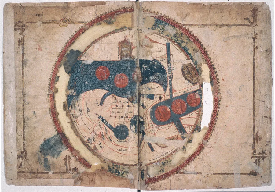
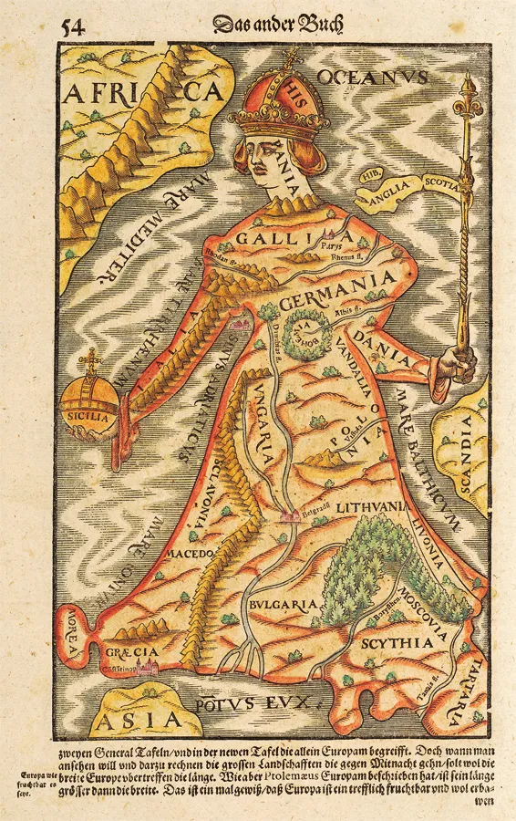
As the scholar who pioneered the deconstructive analysis of maps in the history of cartography, J. B. Harley, points out: “What constitutes a text is not the presence of linguistic elements but the act of construction so that maps, as constructions employing a conventional sign system, become texts.”5 Nowhere is the role of map as text better played out than in the realm of medieval and early modern mapping where, due to the developing skills of the cartographers, there was less concern for scientific exactitude and greater interest in the artistic rendering of thought. See, for example, the mid-sixteenth-century representation of Europe from S. Münster’s Cosmographia (fig. 1.2). To simply dismiss this map as an inaccurate representation of Europe and therefore an invalid source is to miss the point. It is reflective of a much deeper sociocultural, historical, and political context that needs to be read and interpreted. Are the metaphorical coastlines reflective of an emerging consciousness of European supremacy? Can they not be read as a sort of “pre-colonial colonialism” with Spain and Portugal leading the way, assisted by the arm of Italy and the pivotal island of Sicily on one side and by the staff of the North Sea formed by the Danes, the English, and the Scots on the other? The Münster map demonstrates how cartography can be used to navigate the medieval and early modern imagination.
The practice of mapping, representing the world that surrounds us, is not a new one. People have been making maps, in sand, in rock, with pebbles, on the bark of trees, since time immemorial.6 We have grown so accustomed to our modern maps and sophisticated satellite images from space that most of us rarely think of what it must have been like to determine the shape and geopolitical features of the world prior to the existence of chronometers and space technology. It is hard to relocate one’s perspective to that of the medieval Islamic cartographers who had only the assistance of mountains, masts of ships, travelers’ accounts, cosmographic myths, and rudimentary astronomical equipment to guide them. This book aims to guide the reader through the thicket of Islamic maps by presenting three different ways of seeing a selection of them.
The plethora of extant copies produced all over the Islamic world, including India, testifies to the enduring and widespread popularity of these medieval Islamic cartographic visions. For no less than six centuries (eight centuries if we include the nineteenth-century subcontinental examples), these images were perpetuated primarily in a standardized geographic series, sometimes referred to as the Islamic Atlas or the Balkhī school of mapping. I have chosen to disregard this misnomer and have opted instead for a new acronym: the KMMS mapping tradition. I base this acronym on the title of the genre’s most widely disseminated version: Iṣṭakhrī’s Kitāb al-masālik wa-al-mamālik (KMM) (Book of Routes and Realms).7 The “S” appended to the acronym stands for ṣūrat (“picture” in Arabic)—that is, those KMM geographical manuscripts that are accompanied by map images.8
My aim in this book is twofold. First, I will introduce readers to the KMMS maps. Second, I will demonstrate my own approach to reading these maps and how this approach can be employed to expand the boundaries of Islamic history and the history of cartography. In this book, I present a tripartite approach to the KMMS maps of the world. Each part is an interpretive method unto itself and can be categorized respectively as iconography, context, and patronage. Examination from these points of view places the study of medieval Middle Eastern maps within modern and postmodern theoretical paradigms. Taken together, these three analytical modes function like the legs of a tripod, supporting new conclusions about Islamic history and Islamic maps.9
Objectives and Structure of This Book
In this book I explore ways of revising Islamic history using this tripartite approach to medieval Islamic maps. I examine the maps from the point of view of iconography, specifically of one form, the Encircling Ocean; I analyze the way imagination is mapped through a contextual study of a particular place, the lands and deserts of the Beja; and I show via evidence of patronage how the maps can be used as an alternate means of biography.
In chapter 2, “A Look Back,” I survey the work that has been done on the Islamic mapping tradition and discuss the growing role of maps as wellsprings of historical information from material culture.
Chapter 3, “A Sketch of the Islamic Mapping Tradition,” provides essential background to understanding the tradition within which the maps are encased. This is the beginning of a familiarization process that will acquaint readers with these relatively unknown images.
In chapter 4, “KMMS World Maps Primer,” my goal is to make the maps “legible” to the general reader. I discuss the forms that make up the classical Islamic KMMS map of the world and elaborate the matrix of places and spaces that overlay each world map. A reading of this chapter will enable readers to follow the later discussion and deeper reading of the maps that I demonstrate in this book, showing how the maps can be used as alternate gateways into Islamic history and the history of cartography.
Chapter 5, “Iconography of the Encircling Ocean,” is the first of three chapters that focus on the Encircling Ocean form in the world maps. The goal of these chapters collectively is to conduct an iconographic exploration of the Encircling Ocean form, establishing the KMMS maps in their place within a tradition of great breadth in both time and space. This chapter begins this task by offering a broad look at encircling metaform occurrences across a multitude of ancient, medieval, and early modern mapping traditions.
Chapter 6, “Classical and Medieval Encircling Oceans,” considers Greco-Roman and subsequent European cartography from the perspective of the Encircling Ocean form. The chapter works forward in time to medieval maps of European origin, culminating with a remarkable example of intersection between medieval Islamic and European maps.
Chapter 7, “The Muslim Baḥr al-Muḥīṭ,” details medieval Islam’s understanding of the Encircling Ocean from religious and cartographic perspectives, and follows the progression of the form’s symbolic evolution from a marker of unknown terrors to a sign of both earthly and divine power. This chapter concludes the iconographic study of a quintessential feature of the KMMS maps.
Chapter 8, “The Beja in Time and Space,” is the first of two chapters pondering a curious anomaly that occurs in every medieval Islamic map of the world. Located on the eastern flank of Africa is a double-territorial ethnonym for an obscure East African tribe: the Beja. Mention of them in medieval Middle Eastern historiography is rare and, at best, superficial, yet no Islamic map from the eleventh to the nineteenth century leaves them out. The question I raise in this chapter is, quite simply, who were the Beja?
Chapter 9, “How the Beja Capture Imagination,” builds on the answer to chapter 7’s query by asking another question. Knowing who the Beja are, we are led to wonder, why are they absent in Islamic historiography yet ever present on the KMMS world maps? The surprising answers help us to understand how capturing of the imagination of the cartographer affects what makes it onto a world map. This chapter completes my contextual reading of the Beja ethnonym.
Chapter 10, “Meḥmed II and the Ottoman Cluster,” is the first of three chapters in which I conduct a case study approach to the unstudied subject of patronage of Islamic cartography. I employ a Schamaesque approach to reading a set of classical Islamic KMMS maps from the period of Meḥmed II, known as Fātiḥ, “the Conqueror,” because of his conquest of Constantinople in 1452. This chapter begins with a brief survey of work already done on the role of patronage in cartography, and moves on to a consideration of the character of a particular patron, namely, Meḥmed II. I offer an alternate view of Fātiḥ.
In chapter 11, “The KMMS Ottoman Cluster,” I look specifically at the identifying characteristics of the maps I refer to as the Ottoman cluster, embedded within the larger set of KMMS maps. Via the Ottoman cluster reading, I establish that all copies are a product of a particular time and a particular milieu and that they therefore can be read to reveal the sentiments of both the illustrator and his patron.
Chapter 12, “Source of the Ottoman Cluster,” examines the probable origin of the cluster both in terms of the images used and the reason for their use. In this last of the three chapters on these maps, I point out a key manuscript and consider the impact of this work on Meḥmed II. By making a connection between patronage and propaganda, I show how a set of KMMS map manuscripts can be used to provide insights into map audience, patronage, and politics in fifteenth-century Anatolia.
These chapters are intended to be illustrative of a new approach to Islamic cartography. This book does not set out to provide a definitive reevaluation of the whole Islamic mapping tradition. Rather it presents a series of scenarios that illustrate new ways and alternate methodologies for addressing the rich Islamic cartographic heritage. The hope is that this study will pave the way to a major reevaluation of the use of visual sources as an approach to Islamic history and enrich the field of the history of cartography.
![]()
2
A Look Back
Islamic cartography remains an under-studied field. The problem lies in the resistance of Islamic historians to the study of images and new theoretical approaches. Iconographic analysis of im...