![]()
Part One
From Sebastopol to Suez (1854–1869)
![]()
Chapter One
The Mid-Victorian Perspective: A Fragmented East
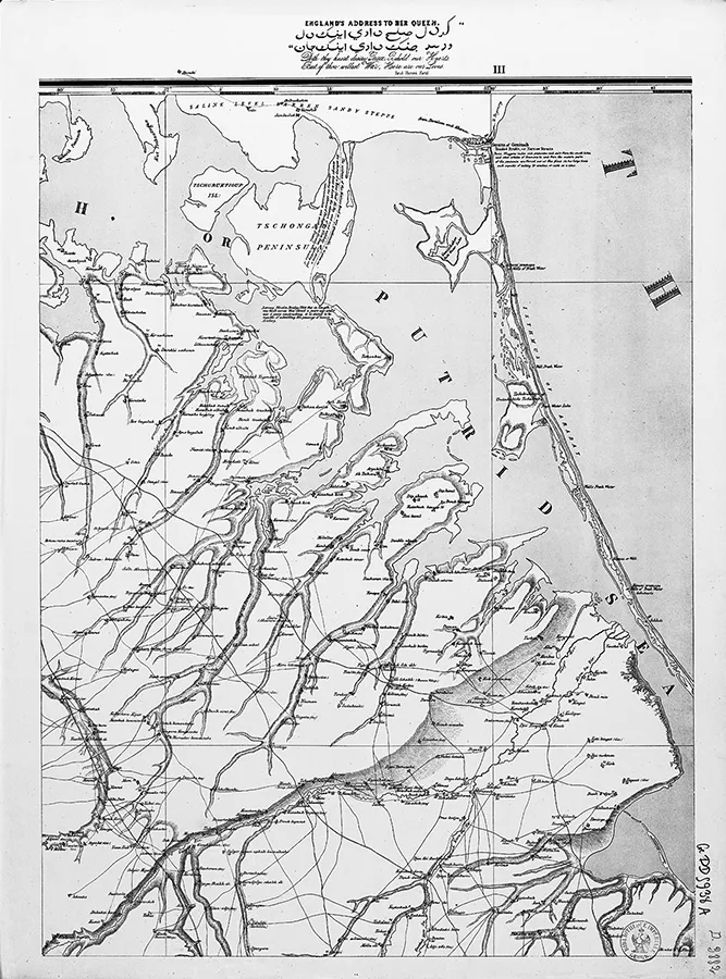
In May 1854, Thomas Best Jervis, a recently retired major in the Bombay Engineers (East India Company), published a map of the Crimean Peninsula in ten sheets (fig. 1.1).1 For years he had stubbornly tried to convince the British government of the crucial importance of topographical intelligence. The Crimean War (1853–56) legitimated his pleas. Lord Newcastle, the secretary of state for war, belatedly realized that cartography was a useful tool for a modern army. What is surprising, in retrospect, is that the landing of the troops and the first weeks of the conflict were planned and managed without reliable maps. While the high command bought a few travelogues, their propensity for exoticism and their intrinsic lack of clarity made them poor instruments for commanding officers. Jervis’s proposal was eventually accepted. He compiled the new 1854 map in a few weeks based on a Russian chart from 1817 by Major General Semën Alexandrovich Mukhin. He could also rely on an Austrian military map and on measurements made in 1833 by General Fëdor Fëdorovich Schubert, a high-ranking infantry officer who was commissioned by the czar to undertake the first triangulation of the Crimea. Because Britain had no actual topographical department, Jervis had to use non-British sources. The fact that he had to convert all the Russian measurements that referred to the Ferro Meridian into Greenwich-compatible coordinates is a testimony to his dependence on foreign data.2 He was fortunate enough that Schubert was a trained surveyor. Jervis used Schubert’s horizontal datum (a reference point to measure other positions), located at the bell tower of Saint Vladimir Cathedral in Sevastopol. Its coordinates were measured with an error of less than 70 feet (1″ at this latitude).3
Once the War Office (WO) agreed to finance the map, it took the retired officer ten days to print two hundred copies of the document. The skillful Jervis was also an accomplished lithographer. This probably explains the high visual quality of the map and his use of colors.4 Jervis wanted his work to serve both the strategist and the tactician. However, the map was poor in terms of its feature accuracy, since Jervis chose to depict relief with hachures. He did not have the sort of hypsometric data needed for correct contour lines. The map key details the different types of roads. Those roads which “troops, artillery, cavalry and baggage waggons” could travel on were, logically, highlighted. Information was provided on the water quality of the wells.5 Other informative insets were less crucial to soldiers. For example, Jervis deemed useful to indicate where the “celebrated Muscat grape is grown.” Jervis’s map was also a travelogue. It was caught between textual explanations and the graphic visualizations of the area. This was a feature of early 19th-century map culture. Cartography was, with travel narratives, one of the many modes of representing geography.
Statistical data and a small, colored geological map complemented the document. The map was a prototype, a fact underlined by Jervis when he delivered his work: “I believe it is not generally known that the present is the first war in which the British forces have been supplied with the most needful help to success, correct and suitable land-maps.”6 Jervis successfully convinced decision makers in London that maps were military instruments. A Topographical and Statistical Department under the authority of the WO was created in 1855.7 A total of 1,476 maps were given to Jervis by the French government to serve as the basis for an archive.
What happened to the map on the battlefield? It is difficult to document its practical uses. The sheets were mounted on linen in order to survive their handling by officers in the Crimea. However, the fact that the map was divided into ten sheets showed little regard for its actual manipulation. A fragmented Crimea could prove of little interest to the officer on the field. A letter by General William John Codrington to Lord Panmure, Lord Newcastle’s successor as secretary of state, nevertheless refers to the map being sent to the British high command, which took the document and other cartographic information into account with sometimes catastrophic consequences.8 Ultimately, old-fashioned ad hoc intelligence, a typical feature of British warfare in the mid-19th century, was the British command’s most reliable source of data. It seems nonetheless that lower-ranking officers did have the map while on the ground. W. H. Russell (1820–1907), who covered the Crimean war for the Times, had heard about the document and its relative inadequacy. The third and fourth sheets show a narrow strip of land named the Arabat Spit. The cartographer located various wells and specified the quality of the water to be found there. The wells did not exist, but, fortunately for British troops, they could quench their thirst anyway, according to Russell: “A curious instance of the ignorance of our chart-makers was discovered on referring to the sites of wells marked on the maps. There were no wells on the Spit at all, and that for the simple reason that they were not required. The water of the Sea of Azoff close to the Spit is quite fresh.”9
Jervis’s map and its uses raise several issues. The first has to do with the data he compiled. Given the lack of any intelligence department in London before the Crimean War, the cartographer relied on external sources, a fact that reveals one of the features of this nascent military intelligence: despite Jervis’s efforts, Britain was surprisingly ill informed.10 Another aspect of the emerging military intelligence is demonstrated by the painstaking process through which Jervis eventually convinced the WO of the relevance of his claims: the major geostrategic power of the mid-19th century could proceed to wage wars without anyone, except for a retired officer, seeing fit to gather a few maps before landing thousands of troops in front of the Russian army. It is true that the Crimea was an unexpected battlefield. France, Britain’s ally in this conflict, was no better prepared. However, the absence of an effective intelligence department in London is revealing of the limited means in the service of mid-19th-century British influence. The fact that a Bombay officer remedied the situation also brings to light the distinct cartographic culture of the Anglo-Indian world. Jervis’s impressive range of surveying and drawing skills is an illustration of this specificity. Such disparities testify to the intrinsic polyphony of the British cartographic vision of the world. Jervis’s map of the Crimea questions the traditional narrative of the cartographic discovery of the Orient, which is often described as an incremental and linear process in 19th-century accounts. Scientific positivism pervaded the rhetoric of geographers and cartographers, but it is misleading.11 Surveys and explorations in the East, far from being cumulative and systematized, were the products of a nexus of heterogeneous and conflicting factors. The WO had its own agenda. The Admiralty charts reveal yet another view of the region. India had its own independent cartographic perspective on western Asia. Not only was there a diversity of official outlooks; there was also a range of semiofficial societies, religion-driven explorers, and adventure-obsessed individuals who were producing their own geographical accounts and maps of the Orient. Jervis’s map was just one reflection of a multitude of Easts mirroring the plurality of mid-Victorian representations.
The present chapter tests these propositions. It first shows the diversity of the agendas underlying the survey of the Middle East–to-be in the mid-19th century. It then examines the random and haphazard processes that lay behind the mapmaking. The position of fieldwork in the dynamic processes that shaped geographical imaginations is of central importance to the understanding of the cultural production of the area. The second section looks into the factors and the technical restraints behind survey expeditions. It describes how the surveyors captured the topography and nomenclature of a place, how spatial knowledge was first collected and recorded before its translation into the printed authority of cartography. This study of exploratory practices emphasizes the limitations and technological determinism that shaped spatial representations. The third section tackles the question of the interactions between the local population and British agents. It pursues one of the main lines of reasoning of this book: the dialectical elaboration of cartographic and geographical knowledge. The chapter goes on to consider one of the first systematic surveying campaigns in the region, that is, the Palestine Exploration Fund project, with a view to observing the interactions of the aforementioned processes through a case study. The last sections describe the final stages of the construction of knowledge, from mapping to mapmaking as such, from the field notes to the cartographic document. It also analyzes to what extent, and how, cartographic documents were used by officials after they were drafted and printed.
1.1 The Motives behind Mapping
Mapmaking and mapping are two interdependent elements of a single process of arranging the world, but they have different constraints and rationale.12 Cabinet cartographers may compile a new map without setting foot outside their office. Surveys required financial support, instruments, and arduous work in the field. Before I study how the East was visualized through maps themselves, this section provides an overview of mid-Victorian surveying in the East. It is intended to unravel the underlying factors that guided the mapping of the area.
The View from the Metropole: An Imperial Gaze?
One of the most obvious uses of maps and surveys in the colonial age was to expand geostrategic influence and domination. In that context, British explorations of Palestine, Mesopotamia, or Sinai are often understood as processes of control. The region that was eventually named the “Middle East” in the early 20th century lay between India and Europe. It controlled the overland route between the East and the West. One would thus expect to discern a coordinated approach in the mapping of the East by governmental departments in the 1850s and 1860s. No such all-encompassing outlook existed in the mid-Victorian era. Each government office interested in the region developed its own approach to the East. Three areas were of special interest from the WO’s point of view: the straits and the Crimea, the Isthmus of Suez, and the borders between Russia and the Ottoman Empire. Each area was mapped on an ad hoc basis, with no indication of an attempt at a prospective and systematic collection of knowledge. Surveys and compilations were in general undertaken after major crises.
Under Jervis’s direction, the Topographical and Statistical Department tried to fill in the gaps by compiling, purchasing, or copying maps of the Ottoman Empire. New surveys were conducted in the region of Erzurum by J. Geils. Heinrich Kiepert’s Karte von Armenia, Kurdistan und Azerbeidschan was bought. A copy of C. F. Skyring’s 1841 map of Beirut was drawn.13 However, this type of comprehensive and prospective approach remained an exception. Under Henry James, the Topographical and Statistical Department returned to a state of somnolence, before the French-Prussian war of 1870 again revealed the archaic state of British intelligence. Prussian advances were attributable partly to the organization of its intelligence and to the quality of its maps.
Even a crucial location like the Isthmus of Suez, despite its growing strategic importance as Ferdinand de Lesseps’s enterprise was moving forward in the 1860s, gave rise to little cartographic interest on the part of the WO.14 The Suez project had initially been considered a utopia by some British officials (Lord Palmerston was among them). The WO eventually realized that it was lacking in up-to-date knowledge of the isthmus and the neighboring Sinai. Charles Warren (1840–1927) and Charles Wilson (1836–1905) surveyed the area in a semiofficial context. Still, Palestine and the Levant in general were strategic sideshows for the WO. The Eastern map of the military was fragmentary and distorted.
The Admiralty’s perspective was quite different from that of the WO, but no less piecemeal. The Mediterranean remained partly uncharted until the 1810s.15 Francis Beaufort, a renowned hydrographer, was sent on a charting mission in the eastern Mediterranean in 1811. Captain William Henry Smyth (1788–1865) succeeded him, followed by Lieutenant Thomas Graves (1802–56) in 1824. Graves came back to the Mediterranean in 1832 after a mission to Tierra del Fuego and charted the region for a decade. He created a modern corpus of sea charts but overlooked Syria. The Levant was eventually surveyed by C. H. Dillon after the British intervention in Beirut in 1840.16 After this burst of interest in cartography, the Syrian coast was left aside again until A. L. Mansell charted the coast between Jaffa and Rosh Haniqra and mapped a few coastal cities.17 Egypt was better known for two main reasons. First, the opening of the Suez Canal required more effective charting of the Egyptian shores. Port Said, Alexandria, and Suez itself were vital stations on the sea route to India. Second, Anglo-Egyptian trade grew considerably in the 1860s.18 The American Civil War compromised cotton exports, causing the British textile industry to look for new suppliers. Egypt was one of them. Merchant shipping relied on the hydrographic expertise of the navy. Both evolutions called for better hydrographic knowledge of the Mediterranean. A series of charts were published from the late 1850s to the 1870s.19 Was there a strategic dimension to the new surveys? For the navy, mapping the sea was one. Nothing really distinguished the Levant from Tanzania. The purpose of the new charts was mostly to supply practicable informatio...