Marine Geology and Geotechnology of the South China Sea and Taiwan Strait
eBook - ePub

Marine Geology and Geotechnology of the South China Sea and Taiwan Strait

  1. 246 pages
  2. English
  3. ePUB (mobile friendly)
  4. Available on iOS & Android
eBook - ePub

Marine Geology and Geotechnology of the South China Sea and Taiwan Strait

About this book

The waters and rich resources of the South China Sea are claimed by seven different countries, and it is estimated that approximately 40% of the world's trade moves through the area. Marine Geology and Geotechnology of the South China Sea and Taiwan Strait examines the physiology, geology, and potential development of this important portion of the western Pacific Ocean's largest marginal sea. The book covers multiple oceanographic topics, and further discusses topography, sedimentation, wave generation, and hazards such as earthquakes, storm surges, and tsunamis. In addition, it explains the engineering issues and design considerations involved regarding a potential Taiwan Strait Crossing, as well as the development of near-shore communities.

Features:


  • Examines seabed material, such as clays, calcareous, siliceous, and various other organic sediments


  • Presents different potential routing strategies for sea crossings using tunnels, bridges, or a combination of both


  • Provides bridge design recommendations considering aesthetics, seismic and wind issues, potential vessel collisions, and more


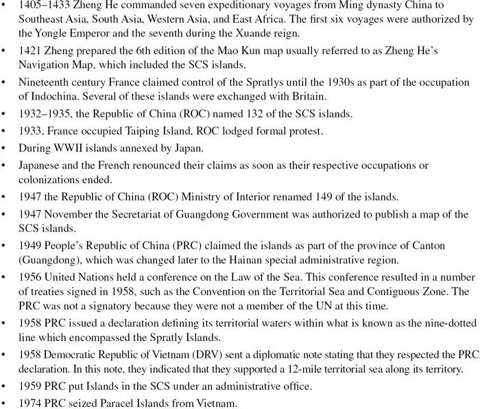
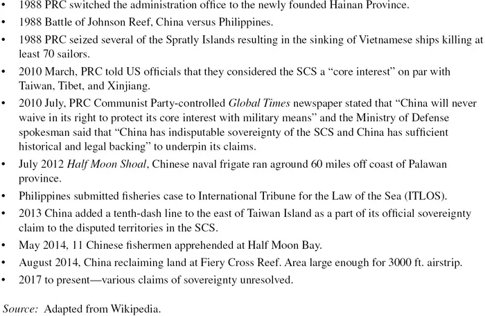
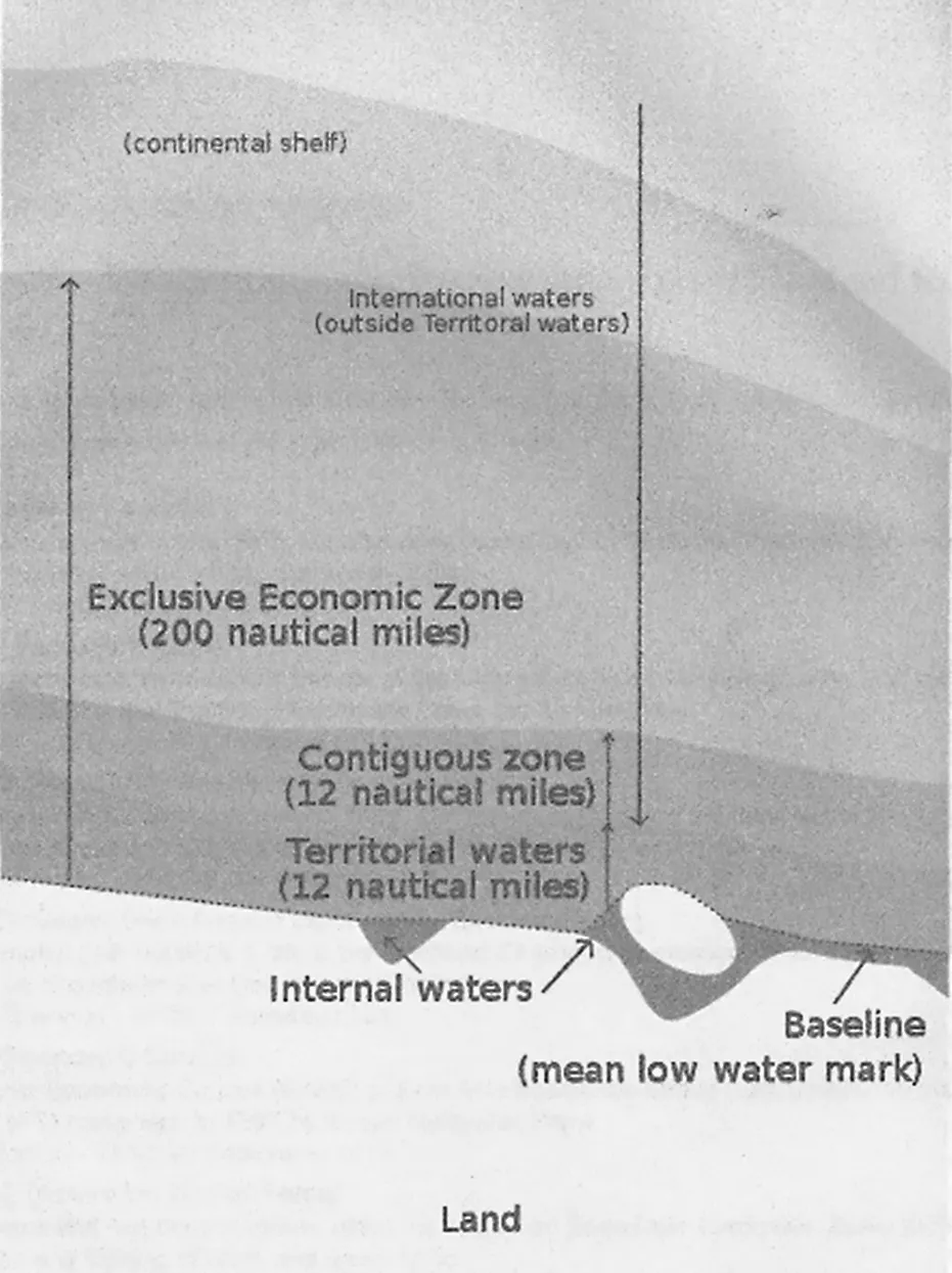
  • Includes a historical timeline and useful maps regarding the political complexity of the area and the various territorial claims made by different nations

Marine Geology and Geotechnology of the South China Sea and Taiwan Strait serves as a valuable resource for geotechnical engineers, marine geologists, civil engineers, and professionals concerned with the region.

Frequently asked questions

Yes, you can cancel anytime from the Subscription tab in your account settings on the Perlego website. Your subscription will stay active until the end of your current billing period. Learn how to cancel your subscription.
At the moment all of our mobile-responsive ePub books are available to download via the app. Most of our PDFs are also available to download and we're working on making the final remaining ones downloadable now. Learn more here.
Perlego offers two plans: Essential and Complete
  • Essential is ideal for learners and professionals who enjoy exploring a wide range of subjects. Access the Essential Library with 800,000+ trusted titles and best-sellers across business, personal growth, and the humanities. Includes unlimited reading time and Standard Read Aloud voice.
  • Complete: Perfect for advanced learners and researchers needing full, unrestricted access. Unlock 1.4M+ books across hundreds of subjects, including academic and specialized titles. The Complete Plan also includes advanced features like Premium Read Aloud and Research Assistant.
Both plans are available with monthly, semester, or annual billing cycles.
We are an online textbook subscription service, where you can get access to an entire online library for less than the price of a single book per month. With over 1 million books across 1000+ topics, we’ve got you covered! Learn more here.
Look out for the read-aloud symbol on your next book to see if you can listen to it. The read-aloud tool reads text aloud for you, highlighting the text as it is being read. You can pause it, speed it up and slow it down. Learn more here.
Yes! You can use the Perlego app on both iOS or Android devices to read anytime, anywhere — even offline. Perfect for commutes or when you’re on the go.
Please note we cannot support devices running on iOS 13 and Android 7 or earlier. Learn more about using the app.
Yes, you can access Marine Geology and Geotechnology of the South China Sea and Taiwan Strait by Ronald C. Chaney in PDF and/or ePUB format, as well as other popular books in Physical Sciences & Chinese History. We have over one million books available in our catalogue for you to explore.

Information

Publisher
CRC Press
Year
2020
Print ISBN
9780367608729
eBook ISBN
9781000222197

Part I

Politics and Resources

1Introduction: Geography, History, and Politics

1.1GEOGRAPHY

The South China Sea (SCS) spans from Singapore and the Strait of Malacca in the south to the Taiwan Strait in the north, and from Borneo and the Philippines in the east to Vietnam and south-eastern China in the west (Figure 1.1). It is one of the world’s largest marginal seas bordering eight countries. The SCS is important, among other things, for its international marine trust for transportation and navigation, its rich marine diversity (including fisheries), its impact on the monsoon climate of Southeast Asian countries, and its mineral resources. The SCS has numerous seamounts and islands. These are mainly coral reefs, atolls, shoals, and sand bars. Many of these features are submerged at high tides, and have no native inhabitants. They are usually clustered into geographical groups, notably the Spratly Islands and Reed Bank offshore of the Philippines, the Scarborough Seamount along the central axis of the SCS, and the Macclesfield Bank and the Paracel and Pratas Islands in the north. Collectively they have a total land area of less than 15 km2 at low tide. The islands are located on a shallow continental shelf with an average depth of 200 m. There are exceptions in the Spratlys, the sea floor drastically changes its depth, and near the Philippines, the Palawan Trough is more than 5000 m deep. In addition, there are some parts that are so shallow that navigation becomes difficult.
image
FIGURE 1.1Schematic figure showing both the South China Sea and Taiwan Strait (Qu et al. 2006) Reprinted with permission of AGU.

1.2POLITICAL DIVISIONS AND TERRITORIAL CLAIMS

Over the millennium, the SCS has served as both a fishery and a pathway for trade, exploration, and conquest. A timeline illustrating the political events affecting the SCS is presented in Table 1.1. At the present time, there are a number of competing claims over whose territory, if any, the marginal sea belongs to. The sea areas recognized in international rights courts are shown in Figure 1.2. A review of this figure shows that territorial waters extend from a shoreline out 12 nautical miles. This is the distance that an eighteenth-century cannon can shoot. The shoreline is defined as the mean low water mark for the purposes of this discussion. The contiguous zone extends from the end of the territorial waters and an additional 12 nautical miles. The exclusive economic zone (EEZ) extends from the shoreline out 200 nautical miles. International waters in maritime law is defined as extending from the end of territorial water seaward. Typically, under maritime law in order to claim sovereignty over an area water the country making the claim must demonstrate exclusive control for a continuous period of time up to the present. No country at the present time bordering the SCS can demonstrate this requirement. A figure presenting the various claims is shown in Figure 1.3.
TABLE 1.1
Political Timeline of the SCS
images

images
image
FIGURE 1.2Sea areas recognized in international rights (Adapted from Image Zones maritimes UNCLS.webp).
image
FIGURE 1.3Competing countries' territorial claims in the South China Sea (Wikipedia Public Domain).

1.3RESOURCES

The SCS was surrounded by some of the world’s fastest developing nations until the Asian financial crisis in 1997. This semi-enclosed sea is a 1.4 million square miles body of wa...

Table of contents

  1. Cover
  2. Half Title
  3. Title Page
  4. Copyright Page
  5. Dedication
  6. Table of Contents
  7. Preface
  8. Acknowledgments
  9. Author
  10. Part I Politics and Resources
  11. Part II Tectonics/Geology
  12. Part III Oceanographic Factors
  13. Part IV Terrestrial and Seabed Sediments
  14. Part V Civil Engineering Development
  15. Index