This book critically explores the relationship between mobility patterns, transport provision and urban development in East African cities.
Bringing together contributions on the futures of mobility in urban East Africa, the chapters examine transport provision, mobility patterns, location-specific modes of transport and transformative factors for transport and mobility in the rapidly urbanising region. The book outlines different mobility needs to be addressed in transport planning to serve and shape the respective cities and examines the decision-making process in transport planning and the level of accountability to the public. The contributors show the dialectic between innovation in transport/mobility and urban development under rapid urbanisation and discusses how to practically integrate mobility and transport provision into urban development.
This book will be of interest to scholars in urban planning, transport planning, transport geography, social sciences and African studies.
Trusted by 375,005 students
Access to over 1.5 million titles for a fair monthly price.
Spatial development and shifting mobility patterns
1The nexus of urban development and infrastructure
Wolfgang Scholz
Introduction
Cities around the world are not just collections of different buildings, infrastructures and public spaces that developed randomly by chance but can be clearly distinguished by typologies. They are spatially organised, driven by economic forces in combination with land tenure arrangements and adjusted by formal planning legislation and urban planning interventions. Thus, an urban structure can be defined as the spatial arrangement and interrelation of different subcomponents which form a certain spatial structure on the basis of the impact of economic driving forces, access to infrastructure mains and natural conditions. One major factor that guides urban development is trunk infrastructure, especially transportation infrastructure, which is the focus here.
In this chapter, two East African cities (Dar es Salaam and Nairobi) will be analysed based on the ideas of the typology of urban structure models. Special attention is paid to the impact of trunk transportation infrastructure in order to gain a deeper understanding of the interrelationship of urban development and trunk mobility infrastructure. The chapter is structured into an introduction considering urbanisation trends in East Africa, the challenges and underlying driving forces, and the role of infrastructure for urban development. The two case study cities of Nairobi and Dar es Salaam are then analysed based on their historical development, planning documents and discussion of the past and present role played by infrastructure in their urban development.
Urban development, urban models and mobility infrastructure
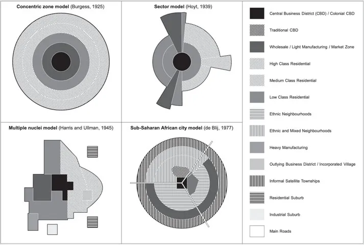
Various theoretical descriptive models have been developed in order to simplify the structure of the different urban spatial settings that organise the various urban functions in space. Models of urban structure were developed to better understand the underlying forces and rules. They were first developed by US-American researchers with reference to North American cities before other researchers picked up the idea and applied it to other cities, including African cities (Figure 1.1). An early descriptive model for contemporary African cities, which followed the ideas of these other models, was created by Harm de Blij during colonial times in 1962 (see Fouberg et al. 1977). South Africa’s urban apartheid model (e.g. Davies 1981) will not be discussed here since it is a unique model and not transferable to other (East) African cities. The same applies to the ancient pre-colonial African cities (see Anderson & Rathborne) which have not had a significant impact on the contemporary cities.
Figure 1.1 Comparison of the four models of urban structure: Burgess, Hoyt, Harris and Ullmann, and de Blij. Author’s figure.
Graphic: Tim Stober
Models of urban structure can generally be divided into concentric, sectoral and polycentric models. The concentric city model displays a dominating city centre with radial development and was developed by Burgess in 1925. It is characterised by a core city with political and economic dominance surrounded by a ring of manufacturing and residential areas for different income groups with decreasing densities towards the periphery. Typically, there is a concentration of all traffic systems towards this centre and lower density in the periphery that inhibits the development of subcentres in peri-urban zones (Jessen 2004).
This simple model seemed not to satisfactorily cover all aspects and features of existing cities, leading to the development of a more advanced successor, the sector model proposed by Hoyt in 1939. It includes the same land-use categories and shows areas of specific land uses along infrastructure axes or following natural features. In the sectoral model, the city centre also serves as the core of the city, but the different spatial sectors with specific land uses develop in a pie-shaped structure following trunk infrastructure lines.
A third model, the polycentric model, however, characterises a city as a space with multiple centres; here the city centre loses its dominant position and competes with other (sub)centres in the urban area. In the polycentric model or multiple nuclei model by Harris and Ullmann from 1945, the core city still exists as a multifunctional centre, but it is supplemented by cooperating and competing smaller centres at the periphery. The existence of subcentres at the periphery leads to a reduction of traffic to the core city with simultaneous development of tangential transport connections (Jessen 2004).
In his model for the African city, de Blij also emphasises a sectoral model following infrastructure lines, but adds aspects of ethnically segregated neighbourhoods (European, Asian and Africans but also separate African ethnic groups) and includes informal settlements which, in the 1960s when the model was created, were not yet the largest component of African cities, in contrast to the current situation in many African cities. In this model, the cities include three CBDs: a remnant of the colonial CBD (with the most vertical development), a transitional business centre where commerce is located at the curbside or storefronts (mostly single-story buildings), and an informal and periodic market zone (usually open-air). The quality of residences tends to deteriorate towards the periphery. At the time of its creation in the 1960s, the model lacked areas of elite, middle class or gentrified residential zones as well as new clusters at junctions such as now exist. Today, global investment in new urban developments, both residential and commercial, are also having an increasing impact in African cities (Splinter & Van Leynseele 2019). Nevertheless, the idea of multiple CBDs and a segregated city continues to be valid.
Cities do not necessarily strictly follow only one model but can include aspects of different models. However, for all models, the role of trunk infrastructure is important since it defines the core at the junction of main roads, connects the different parts of the urban area with transportation and provides preferred areas for industry or other commercial land uses depending on access to infrastructure and customer flow.
Usually, trunk infrastructure follows the urban structure, and, at the same time, large-scale infrastructure guides urban development in certain geographical directions. This applies to most formally planned cities since urban planners and infrastructure development departments depend on each other to develop areas at reasonable costs.
Thus, all models display a strong interdependency between urban development, land-use changes and infrastructure, mainly roads. In Sub-Saharan cities, in an environment of highly constrained public sector resources with low investment levels and large growth control deficits, the provision of trunk infrastructure (foremost water mains and roads) constitutes one of the few remaining instruments to guide urban development:
Urban planners can influence city shapes only indirectly. Market forces in the long run are building cities… . But market forces respond to constraints constituted by regulations and taxations and to opportunities provided by the network of primary infrastructure built by the state.
(Bertaud 2002: 24)
Planners thus have, according to Bertaud, only three tools at their disposal to influence urban spatial structures: land-use regulations, infrastructure investments and taxation (Bertaud 2002: 24). Hence, the potential role of trunk transport infrastructure on urban development in Sub-Saharan cities will be considered in this chapter.
Urban development and infrastructure in (East) Africa
In the following, with reference to the urban models introduced previously, the structural, spatial and infrastructural development in urban areas with a special focus on East Africa will be discussed.
Urban development in (East) Africa, trends and challenges, driving forces
With more than half the world’s population living in cities, urbanisation has become a prime feature of global human habitation. Although still far behind the urbanisation levels of other regions, cities in Africa have taken the lead in urban growth rates during the last decades, with forecasts estimating there will be 760 million urbanites representing 50% of the continent’s population by 2030 (UN Habitat 2010). While large-scale urbanisation in Sub-Saharan Africa is a new phenomenon, Africa’s path into the urban era is considered to be unique in its growth rates and – at the earlier stages of urbanisation some decades ago – in its manifestation as a rather “poverty-driven process and not the industrialization induced socio-economic transition it represented in the world’s other major regions” (UN Habitat 2010: 7). These factors contribute to the specific urban morphologies as well as typologies and technologies of service provision, including transportation, which are the topics of this book. Today, we also see rather a diverse picture of settlements ranging from growing slums and informal areas to well-planned and serviced new neighbourhoods or even satellite towns (see Nairobi) for the growing middle class with much in common with similar market-driven developments on other continents.
A still-dominant feature of the Sub-Saharan city today is the excessive expansion of informal settlements into the periphery, which is the prevailing pattern of so-called urban growth under poverty. While vertical densification is still rare in African urban cities and applies mostly to newly constructed office buildings by (international) developers, extensive horizontal development dominates, particularly along the major infrastructure arteries radiating from the city centre into the periphery. Apart from location and land tenure, the availability of infrastructure services constitutes the most important factor influencing the value of land and the patterns of urban growth. Informal urban development follows the few infrastructure lines in place, and urban patterns have changed from a concentric to a finger-type model (Kreibich et al. 2005). The finger-type model is a variant of the sector model that leaves the areas between the fingers less developed due to the distances that need to be covered in order to connect with trunk infrastructure. Dar es Salaam serves well as an example for this model (see later).
Another aspect of rapid urbanisation in Sub-Saharan African countries is that ailing states are not in a position to deploy a responsive legal framework and to mobilise adequate human and material resources to guide ur...
Table of contents
Cover
Half Title
Series
Title
Copyright
Contents
List of figures
List of tables
List of contributors
Introduction
Part 1 Spatial development and shifting mobility patterns
Part 2 Modes of public transport beyond the car
Concluding reflections
Index
Frequently asked questions
Yes, you can cancel anytime from the Subscription tab in your account settings on the Perlego website. Your subscription will stay active until the end of your current billing period. Learn how to cancel your subscription
No, books cannot be downloaded as external files, such as PDFs, for use outside of Perlego. However, you can download books within the Perlego app for offline reading on mobile or tablet. Learn how to download books offline
Perlego offers two plans: Essential and Complete
Essential is ideal for learners and professionals who enjoy exploring a wide range of subjects. Access the Essential Library with 800,000+ trusted titles and best-sellers across business, personal growth, and the humanities. Includes unlimited reading time and Standard Read Aloud voice.
Complete: Perfect for advanced learners and researchers needing full, unrestricted access. Unlock 1.5M+ books across hundreds of subjects, including academic and specialized titles. The Complete Plan also includes advanced features like Premium Read Aloud and Research Assistant.
Both plans are available with monthly, semester, or annual billing cycles.
We are an online textbook subscription service, where you can get access to an entire online library for less than the price of a single book per month. With over 1.5 million books across 990+ topics, we’ve got you covered! Learn about our mission
Look out for the read-aloud symbol on your next book to see if you can listen to it. The read-aloud tool reads text aloud for you, highlighting the text as it is being read. You can pause it, speed it up and slow it down. Learn more about Read Aloud
Yes! You can use the Perlego app on both iOS and Android devices to read anytime, anywhere — even offline. Perfect for commutes or when you’re on the go. Please note we cannot support devices running on iOS 13 and Android 7 or earlier. Learn more about using the app
Yes, you can access Transport Planning and Mobility in Urban East Africa by Nadine Appelhans, Wolfgang Scholz, Sabine Baumgart, Nadine Appelhans,Wolfgang Scholz,Sabine Baumgart in PDF and/or ePUB format, as well as other popular books in Technology & Engineering & Urban Planning & Landscaping. We have over 1.5 million books available in our catalogue for you to explore.