This book explores the prejudice against slave descendants in highland Madagascar and its persistence more than a century after the official abolition of slavery.
'Unclean people' is a widespread expression in the southern highlands of Madagascar, and refers to people of alleged slave descent who are discriminated against on a daily basis and in a variety of ways. Denis Regnier shows that prejudice is rooted in a strong case of psychological essentialism: free descendants think that 'slaves' have a 'dirty' essence that is impossible to cleanse. Regnier's field experiments question the widely accepted idea that the social stigma against slavery is a legacy of pre-colonial society. He argues, to the contrary, that the essentialist construal of 'slaves' is the outcome of the historical process triggered by the colonial abolition of slavery: whereas in pre-abolition times slaves could be cleansed through ritual means, the abolition of slavery meant that slaves were transformed only superficially into free persons, while their inner essence remained unchanged and became progressively constructed as 'forever unchangeable'.
Based on detailed fieldwork, this volume will be of interest to scholars of anthropology, African studies, development studies, cultural psychology, and those looking at the legacy of slavery.
Trusted by 375,005 students
Access to over 1.5 million titles for a fair monthly price.
The people known today as the Betsileo occupy a large territory of the southern highlands of Madagascar.1 Administratively speaking, the Betsileo homeland is situated in Amoron’i Mania and Matsiatra Ambony, the two faritra (regions) that were parts of the former faritany (province) of Fianarantsoa. In geographic terms, Betsileo territory is roughly situated between the Mania River to the north and the Andringitra chain and the Zomandao River to the south. The eastern side of Betsileo territory ends approximately when the rainforest starts, while the western part extends into vast areas that are only scarcely populated until one reaches the region inhabited by the Sakalava. The immediate neighbours of the Betsileo are the Merina (north), the Betsimisaraka (north-east), the Zafimaniry (north-east), the Tanala (east), the Bara (south) and the Sakalava (west).
The use of the name ‘Betsileo’ for the people living in the southern highlands is recent and dates back to the creation of a Betsileo province by King Radama I (1793–1828) after his conquests in the early nineteenth century. Prior to being subjected to Merina rule, the region that was going to be known as Betsileo comprised many petty kingdoms. The kingdoms of Isandra and Lalangina are usually seen as the most important of these polities since they had a state-like organisation (Kottak 1977; 1980: 66–87). To the north of Isandra and Lalangina was the kingdom of Manandriana; to the south was the region constituted of separate kingdoms (Tsienimparihy, Vohibato, Alananindro and Homatsazo) and which came to be known as Arindrano after its ‘unification’ by Radama I.2
Most scholars draw a distinction between the north and the south of Betsileo country because of their different histories. North Betsileo includes today the regions of Manandriana, Ambositra and Fisakana, which are located north of the Matsiatra River. This area was once part of the sixth division of Imerina before being annexed to the Betsileo province and administrated by the Merina governor of Fianarantsoa. Except for the region of Manandriana, which has a long history, the area now called North Betsileo became densely populated and politically organised only under Merina rule in the nineteenth century (Kottak 1980: 304–305; Freeman 2001: Chapter 2). As a result, its inhabitants are something of a mix between Merina and Betsileo. The region south of the Matsiatra River, by contrast, had an important political and economic history long before Merina annexation. The Merina kings called this region andafy atsimon’i Matsiatra (‘south across the Matsiatra’). In the literature, it is sometimes called for this reason the ‘historical’ Betsileo. Yet, although the Betsileo as an ethnic group is by and large an invention of Merina administration that was subsequently taken on by French colonial rulers, today all the people from the northern and southern parts of the territory call themselves Betsileo. It is nonetheless important to bear in mind that the people I studied, who live in the extreme south of the Betsileo region, acknowledge that their fombandrazana (ancestral customs) differ from the Betsileo who live further north. This is true even though, as we shall see, many of my informants claimed that their ancestors came from northern Betsileo. Such differences and awareness make it difficult to give an encapsulated description of Betsileo society that would unambiguously apply to the north and the south.3
Today, the majority of southern Betsileo are rice-growing peasants living in villages and hamlets in the vicinity of their rice fields. People also raise cattle (omby, i.e. zebus), especially in the extreme southern region, but they do so in a much smaller proportion than their southern neighbours, the pastoral Bara. In the fairly recent past, cattle-raising was more important and rice cultivation did not occupy the central place that it has now in the southern Betsileo economy. The local economy shifted to an intensive rice-growing agriculture under Merina rule during the nineteenth century, not least because the Merina directly encouraged its cultivation. Local peasants had to grow rice because of fiscal pressure: they had to cultivate it intensively in order to make a surplus to generate income. This income was required in order to pay the heavy taxes imposed by Merina rulers (Ralaikoa 1987: 34).
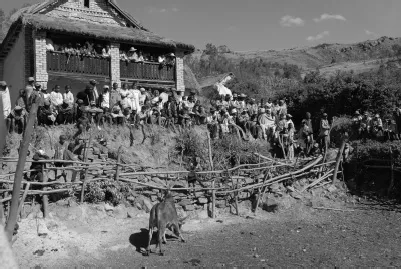
This transformation of the economy also deeply modified the rural settlement patterns of the southern Betsileo. During the eighteenth century and until the second half of the nineteenth, people mostly lived in fortified villages on hilltops. It was important to protect oneself in fortified sites because wars between local lords and raids from outsiders were frequent. In wars, as in raids, captives were taken to be sold as slaves. When the risk of inter-polity war decreased under Merina rule and when southern Betsileo had to become wet-rice cultivators in order to pay their taxes, things changed rapidly: the fortified village on a hilltop was no longer seen as the most desirable mode of settlement. Land was allocated to people, and families established themselves close to their rice fields, forming small hamlets protected by a circular hedge of thorny trees and cactuses. These hamlets were named vala (cattle pen) since they were organised around a corral (see Figure 1.1). Manure was transported down to the rice fields thanks to a canal passing through the pen. This ingenious and efficient technique allowed peasants to increase their production of rice.4 At the same time, however, the move to the vala and the general impoverishment of the population because of heavy fiscal pressure meant that the numbers of cattle owned by southern Betsileo peasants significantly decreased, in particular in the region of Ambalavao (Ralaikoa 1987: 299).
The basic units of southern Betsileo social organisation are the tomb-centred, named local descent groups, which are called foko or firazanana. Membership to these groups is cognatic, optative and non-exclusive, but shows a strong patrilineal bias since most people prefer patrilocal post-marital residence and they are most often buried in their father’s tomb than in others (Kottak 1971; 1980), even though they have the right to be buried in a number of tombs built by the descent groups to which they belong. Ancient Betsileo society was made up of three endogamous status groups: hova (nobles), olompotsy (commoners) and andevo (slaves). As the present book will show in some detail, this division of all Betsileo into three categories continues to be relevant.
Figure 1.1 A descent group gathering around their cattle corral (vala)
Until the Merina conquest, Betsileo polities were independent, state-like formations organised around a mpanjaka (ruler) of noble descent.5 They had capitals which were fortified hilltop villages with a lapa (royal residence) and a number of people surrounding the rulers; i.e., advisers, servants, soldiers and slaves. Inter-polity wars were endemic in the southern highlands but were stopped by Merina rule, which became effective in the southern part of Betsileo country only after the conquests of Radama I between 1810 and 1820. Nonetheless, a climate of general insecurity continued to exist in these regions, since, on the fringes of the kingdom, Merina garrisons could only exert loose control and could not prevent raids by outsiders, especially the Bara neighbours.6 In the south of Arindrano, the Merina established in 1852 a garrison in Ambohimandroso which became the administrative and economic centre of the area, headed by a Merina komandy (governor). It is also in Ambohimandroso that the Christian missions first established themselves in the region (Raherisoanjato 1982b). In 1899, however, the French colonial administrator, General Joseph Gallieni, decided to make the then small village of Ambalavao the new administrative and economic centre. Since then, Ambalavao has remained the main town in the extreme south of the Betsileo homeland, with a current population of around 30,000 inhabitants.
A brief historical sketch of Beparasy
The region of Beparasy where I conducted most of the research discussed in this book is located in the south of Arindrano, between the basin of Ambalavao and the Andringitra chain, a mountain range forming a natural frontier between Betsileo and Bara areas. Because of the region’s altitude, its proximity to high, rocky mountains and its exposure to the winds, its climate is pleasantly mild during the hot season but can be relatively cold for the rest of the year. Considering the high level of insecurity that existed in the southern highlands until the end of the nineteenth century, one may find it somewhat surprising that people decided to make this cold, remote and somewhat risky corner their home. In this section I want to explain why they chose to do so and the particular circumstances through which this happened. My account is mostly based on oral histories that I collected in Beparasy and Ambalavao.7
Beparasy is located in the former territory of a polity that was part of Arindrano. This polity was divided in the early nineteenth century by Radama I, as part of his political strategy after the relative failure of trying to unite the polities of Arindrano under the authority of Rarivoarindrano (Raherisoanjato 1984b: 230). The polity was then split into a northern and a southern part, with two different rulers. The ruler of one of these two halves established his lapa (royal residence) on the top of a hill that I shall call here Ambatofotsy.8
The hilltop village with the royal residence in Ambatofotsy was abandoned a long time ago and the fanjakana (government) is to be found today in the village which is the seat of the kaominina (commune). It is situated in a valley close to Ambatofotsy hill, and descendants of the former rulers still live in the village. Their house stands at its centre, besides a large kianja (gathering place) with a massive vatolahy (standing stone), and is still called lapa by villagers. A few other descendants of hova (nobles) live in the area around the village. Oral traditions recall that the polity governed by the rulers of Ambatofotsy was sparsely populated until the beginning of the nineteenth century, with the arrival of many people fleeing Radama’s wars, most notably after the massacres committed by his army at Ifandana and the enslavement of part of the population (on this tragic episode, see Dubois 1938: 223–226).
The region of Beparasy, located a few hours’ walk from Ambatofotsy and the seat of the commune, remained unoccupied until an even more recent date. I was told that only mpiarakandro (‘those who go with the day’, i.e. cattle herders) went up seasonally to let their zebus graze on the banks of the river meandering through its valleys. These herders came mainly from the north, but also occasionally from the west. Beparasy elders tell stories about the vakirà (blood bond) that a Betsileo noble once contracted with a Bara ruler to strengthen their agreement on the sharing of pasture. The agreement stipulated that the Bara would drive their zebus to the west, whereas the Betsileo would lead theirs to Beparasy. Local historians also explain that in a much more distant past the region was inhabited by Vazimba, whose presence is testified, they say, by the ancient tombs and megaliths found in the nearby mountains.9 Contemporary Beparasy villagers thus see themselves as the third wave of inhabitants of the region, after the Vazimba and the seasonal herders.
It was only towards 1880 that people started to intensively cultivate land in Beparasy. According to my informants, mitady tany malalake (‘looking for free, spacious land’) was the principal reason for their ancestors’ arrival. As I have explained, since the transformation of the Betsileo economy into an intensive rice-growing agriculture, people have been continuously forced to migrate to find new cultivable land. A few people also recalled that their forebears fled the heavy burden of fanompoana (royal service) and hetra (taxes) imposed by Merina administration in northern Betsileo, where these obligations were probably more easily enforced than in the recently conquered and less administered south. Another possible factor encouraging the move towards the less populated and remote southern regions, although it was never mentioned to me, may have been the many epidemics that plagued the more densely populated Betsileo areas during the nineteenth century (Campbell 2005: Chapter 6). Whatever the reasons, it seems that most of these settlers came from parts of the southern highlands that are now considered Betsileo. While some arrived from other parts of Arindrano, many came from much further north, sometimes from regions located to the north of Fianarantsoa.
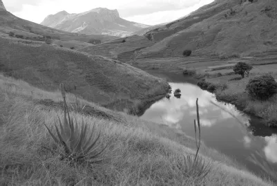
What made the region of Beparasy particularly attractive to newcomers in spite of its cold climate and remoteness was the abundance of water (see Figure 1.2). Sources coming from the nearby mountains provide water during most of the year, and the river that passes through the region never dries up, even during the most severe droughts. By comparison, permanent water sources are rare in the basin of Ambalavao, where only two of the basin’s numerous rivers never dry up (Portais 1974: 17). Above all, any peasant wanting to cultivate wet rice needs to find a site that allows a good and easy management of water supply. The region of Beparasy offered good opportunities for such endeavours.
Figure 1.2 Landscape of the southern highlands during the dry season
According to oral histories, the first people to arrive were four men named Rainibao, Raikalatsara, Rakamisy and Rainidama. Three of these four (Rainibao, Raikalatsara and Rakamisy) occupied the top of a strategically located hill that I shall call Vatobe. From its summit they had a very good overview of the whole area. Since Rainidama, the fourth man, was in charge of supervising a somewhat remote place, he founded a village on a separate hilltop. With their kinsmen and affiliates, these men worked hard to lay out farihy (i.e., rice fields in wet valley bottoms) on the river banks. Since the land was at that time partly covered by a forest, the first settlers had to clear it in order to build their rice fields. Later, when the population increased and the well-irrigated fields in the valley bottoms were not enough to feed everyone, Beparasy villagers had to carve out kipaha – i.e., terraced rice fields on the hills’ slopes – which required an elaborate hydraulic system of reservoirs and canals in order to make use of the water flowing from the mountains.
Insecurity prevented these new settlers from leaving their hilltop villages during the ...
Table of contents
Cover
Half Title
Series
Title
Copyright
Dedication
Contents
List of illustrations
Acknowledgements
Note on language
Map of Madagascar
1 An encounter with southern Betsileo ‘slaves’
2 Three lenses: ethnography, history and cognition
3 The Berosaiña
4 Contested histories
5 Marriage in Beparasy
6 Unilateral unions and their consequences
7 Mixing ancestries and keeping a memory of origins
8 Essentialism: evidence, development and transmission
Conclusion
Appendix
References
Index
Frequently asked questions
Yes, you can cancel anytime from the Subscription tab in your account settings on the Perlego website. Your subscription will stay active until the end of your current billing period. Learn how to cancel your subscription
No, books cannot be downloaded as external files, such as PDFs, for use outside of Perlego. However, you can download books within the Perlego app for offline reading on mobile or tablet. Learn how to download books offline
Perlego offers two plans: Essential and Complete
Essential is ideal for learners and professionals who enjoy exploring a wide range of subjects. Access the Essential Library with 800,000+ trusted titles and best-sellers across business, personal growth, and the humanities. Includes unlimited reading time and Standard Read Aloud voice.
Complete: Perfect for advanced learners and researchers needing full, unrestricted access. Unlock 1.5M+ books across hundreds of subjects, including academic and specialized titles. The Complete Plan also includes advanced features like Premium Read Aloud and Research Assistant.
Both plans are available with monthly, semester, or annual billing cycles.
We are an online textbook subscription service, where you can get access to an entire online library for less than the price of a single book per month. With over 1.5 million books across 990+ topics, we’ve got you covered! Learn about our mission
Look out for the read-aloud symbol on your next book to see if you can listen to it. The read-aloud tool reads text aloud for you, highlighting the text as it is being read. You can pause it, speed it up and slow it down. Learn more about Read Aloud
Yes! You can use the Perlego app on both iOS and Android devices to read anytime, anywhere — even offline. Perfect for commutes or when you’re on the go. Please note we cannot support devices running on iOS 13 and Android 7 or earlier. Learn more about using the app
Yes, you can access Slavery and Essentialism in Highland Madagascar by Denis Regnier in PDF and/or ePUB format, as well as other popular books in Social Sciences & African History. We have over 1.5 million books available in our catalogue for you to explore.