![]()
1
THE HIGHEST STATE
The young college professor hoped to see the Colorado prairies and mountains from the top of Pikes Peak. For a young woman in 1893, that trip would have been quite an adventure. So Katharine Lee Bates and some friends hired a wagon and a driver and started up America’s most famous mountain.
The trip thrilled Professor Bates. Atop Pikes Peak she wrote: “I was looking out over the sea-like expanse of fertile country” when the opening lines of a poem “floated into my mind”:
O beautiful for spacious skies,
For amber waves of grain,
For purple mountain majesties
Above the fruited plain!
These lines from her poem became the beginning of the song “America the Beautiful.” Years later, Denver poet Thomas Hornsby Ferril wrote a poem about the community in which he lived for over ninety years. “Two Rivers” describes the South Platte River and Cherry Creek and the people who came to settle along their banks in Denver:
Two rivers that were here before there was
A city here still come together: one
Is a mountain river flowing into the prairie;
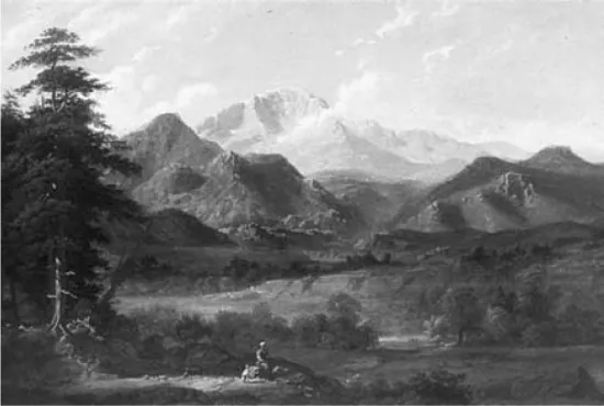
Pikes Peak, America’s most famous mountain, has become Colorado’s best-known landmark. It inspired English teacher Katharine Lee Bates to write “America the Beautiful.”
1872 PAINTING BY GEORGE CALEB BINGHAM.
One is a prairie river flowing toward
The mountains but feeling them and turning back
The way some of the people who came here did.
Ferril wrote about the mountains, prairies, water, and people—the major factors in Colorado’s history. He noted that Cherry Creek is one of the few creeks that flows toward the mountains instead of out of them.
Like millions of other people, Katharine Lee Bates and Thomas Hornsby Ferril marveled at the wonders of Colorado. The high mountains most impressed the poets, as well as many other visitors and Coloradans alike. “The Highest State” is what writers over 100 years ago called our state.
COLORADO ABOVE ALL
Colorado has the highest average elevation—6,800 feet above sea level—of the fifty states. If we leveled Colorado out to an average elevation of 1,000 feet, it would be the biggest state in the United States—larger than Texas or Alaska.
Mount Elbert (14,431 feet) is the highest point in Colorado and the fourteenth-tallest mountain in the nation. Alaska has twelve taller mountains and California has one. Colorado, however, has fifty-four peaks that are 14,000 feet or higher. These are often known as Colorado’s “fourteeners.” The lowest point in the state is in the Republican River Valley near Wray, where the tiny town of Laird is 3,402 feet above sea level.
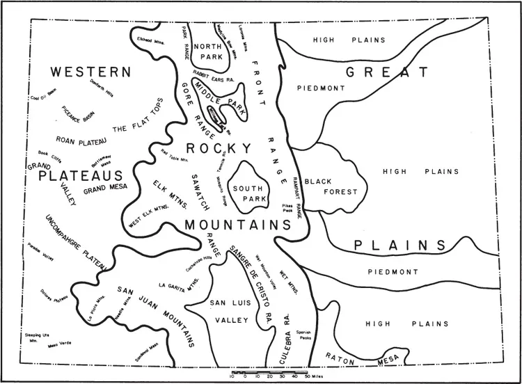
Landforms map. From the Historical Atlas of Colorado.
COURTESY, UNIVERSITY OF OKLAHOMA PRESS.
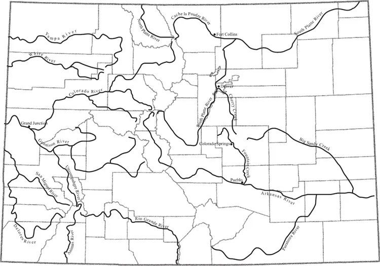
Rivers of Colorado.
MAP BY NICHOLAS WHARTON.
Colorado is the only state that is an almost perfect rectangle. At its widest, Colorado stretches 387 miles from the Kansas border to Utah. It is 276 miles from the Wyoming border on the north to the New Mexico border on the south. It is the eighth-largest state, with a total area of 104,247 square miles.
Colorado became a state in 1876, the same year the United States celebrated its centennial, or 100th birthday. That is how Colorado got one of its nicknames, “the Centennial State.” The state is divided into sixty-four counties, with Las Animas and Moffat the largest in area and Gilpin the smallest. Broomfield, the newest county, was carved out of Boulder, Jefferson, Adams, and Weld Counties in 2001. In each county one town is designated the county seat. Denver is the state capital and Colorado’s largest city.
RIVERS
Colorado holds the US record for the deepest single snowfall—95 inches. This 32-hour continuous snowstorm fell at Silver Lake near Silverton on April 14–15, 1921.
Heavy snowmelt in spring and summer feeds Colorado’s rivers. Our state is called the “mother of rivers” because so many waterways start in our mountains.
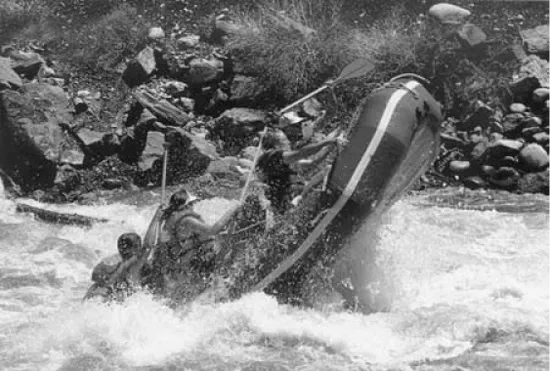
You can explore Colorado’s rivers on tubes, rafts, canoes, or kayaks. These river rats are riding the Arkansas River.
COURTESY, SANBORN SOUVENIR COMPANY.
Rivers radiate out of the state like the spokes of a wheel. The mighty Colorado River begins in Rocky Mountain National Park and flows 1,450 miles to reach the Gulf of California and the Pacific Ocean. The Rio Grande, which means “Grand River” in Spanish, is even longer—1,885 miles—and flows into the Gulf of Mexico. The Arkansas flows from Fremont Pass near Leadville through southeastern Colorado. After a journey of 1,450 miles, it joins the Mississippi River in the state named Arkansas.
In the central Colorado mountains, something very unusual occurs. From starting points within a few miles of each other, water rolls in four different directions toward the sea. Part of it flows west into the Colorado River, some flows south into the Rio Grande, some southeast into the Arkansas River, and some northeast into the South Platte River. After starting out close together, these rivers will be separated by thousands of miles when they finally reach the sea. Rivers, as we shall see, have played a very important role in Colorado’s history. Settlers, animals, plants, and industry all need water.
CLIMATE
Because Colorado has such a variety of climates and elevations, it has recorded some extreme temperatures. The coldest temperature recorded was 61 degrees below zero at Maybell, Moffat County, on February 1, 1985. The hottest was 118 degrees at Bennett in Adams County on July 11, 1888. In addition, the weather on the Eastern Slope of Colorado is often completely different from the weather on the Western Slope. Rapidly changing climate conditions can raise or lower the temperature as much as 50 degrees in one day. Snow falls somewhere in Colorado during every month of the year. Leadville has had several snowfalls on July 4.
Colorado’s climate has shaped the history and development of the state. Farming, mining, ranching, tourism, town building, industry, and transportation have all been changed by climate and geography. Few other states offer such breathtaking scenery, varied animal and plant life, and variety of climates.
Eastern Plains
Look at Colorado’s geographic regions on the landforms map. The state is naturally divided into three parts. The first region visitors from the eastern states saw was the eastern plains. This is part of the region called the Great Plains, which stretches eastward from the Rocky Mountain states through North Dakota, South Dakota, Nebraska, Kansas, Oklahoma, and Texas.
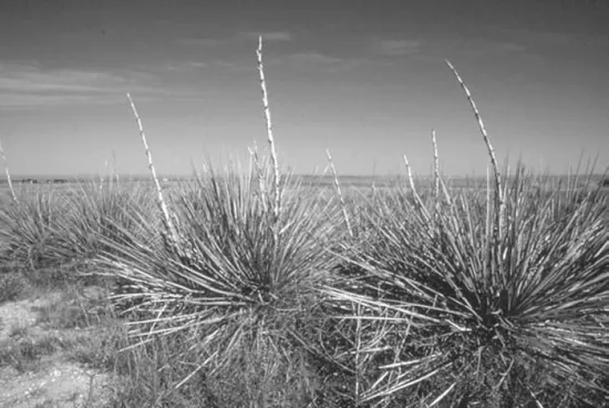
Colorado’s high plains were mapped as “the Great American Desert” by explorer Stephen Long. He found that yucca was one of the few plants that thrived on the flat, dry landscape.
COURTESY, OVERLAND TRAIL MUSEUM, STERLING, CO.
The plains slope down from foothills of the Front Range, or the Eastern Slope of the Rocky Mountains. The Front Range stretches south from Fort Collins to Boulder, Denver, Colorado Springs, Pueblo, and Trinidad. Rainfall is scant in this region. These eastern plains are windy in the spring and well-known for their dust storms, heat, hail, and summer droughts, or dry spells. Because of these conditions and the sparse summer vegetation, early visitors called the plains “the Great American Desert.” The region is not a desert at all, but it seemed that way to people who were used to the lush green forests of the eastern United States.
Native grasses grow well on this prairie land. Buffalo, antelope, and other animals have thrived on these grasses, and numerous Native American peoples settled on the plains to hunt the animals. Because of the rich grasslands, Colorado’s eastern plains became an important cattle-ranching region. When Europeans began to arrive, they first settled along the rivers and then moved onto the drier land. The eastern plains, which are at a lower elevation than the rest of Colorado, have a longer growing season (the number of days between the last frost of spring and the first frost of fall). The region is also well-known for its sunshine and its special beauty.
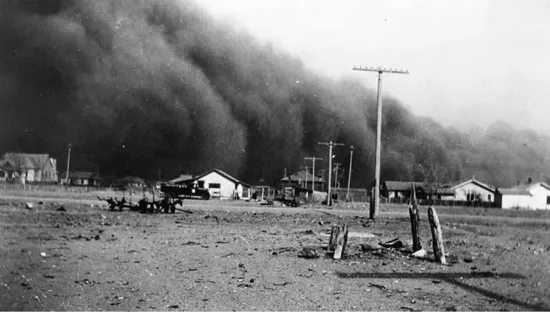
Pioneers found that Colorado was a dry state, averaging only 16.6 inches of precipitation a year. Drought and wind created dust storms that wiped out farms, such as this one in Baca County.
COURTESY, LIBRARY OF CONGRESS, WASHINGTON, DC.
Mountains
Colorado has always been famous for its mountains, especially Pikes Peak, the state’s first mountain to be named on maps. Tourists have been climbing or riding to the top of the 14,110-foot-high Pikes Peak for many years. You can hike, drive, or take a cog railroad to the top.
Mountains stretch from the rolling foothills along the Front Range to the high Continental Divide and then westward. The Continental Divide is a ridge of mountains that separates the water flow between east and west. On the Eastern Slope, water runs east to the Mississippi River and the Gulf of Mexico. Water running off the Western Slope eventually reaches the Pacific Ocean via the Colorado River.
The mountains of Colorado are part of a larger chain called the Rocky Mountains, which run from Canada into Mexico. The Rocky Mountains reach their highest elevation and greatest width in Colorado. Within the Rockies are other, smaller ranges. The Spanish, the first Europeans to explore much of Colorado, named many of these ranges. After seeing the red sunset on its snowcapped peaks, they christened the Sangre de Cristo Range for the blood of Christ. They named the La Platas after the silver they found there and the San Juans for Saint John.
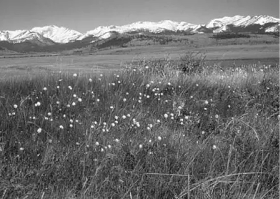
South Park, in the heart of Colorado, is a flat, mountain-rimmed valley.
PHOTO BY THOMAS J. NOEL.
In the Rocky Mountains of Colorado are four great “parks,” or large mountain valleys: North Park, Middle Park, South Park, and the San Luis Valley (originally San Luis Park). The San Luis Valley and South Park are the largest of these parks.
These parks, once filled with buffalo, elk, deer, and antelope, were the hunting grounds for Native Americans and ...