![]()
PART I
The Story of the Macomb San Juan Exploring Expedition
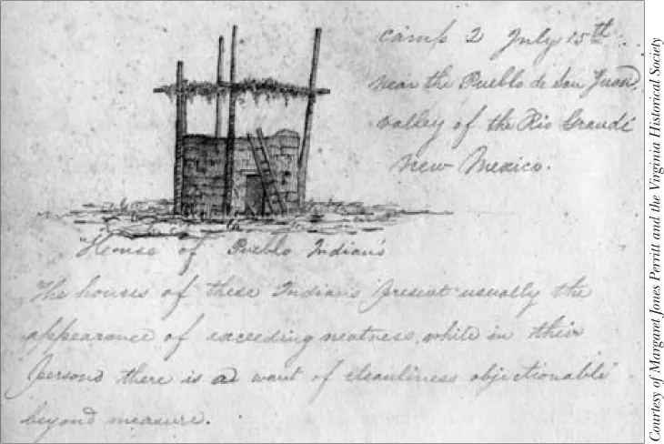
Sketch of a Pueblo Indian house, by Charles H. Dimmock.
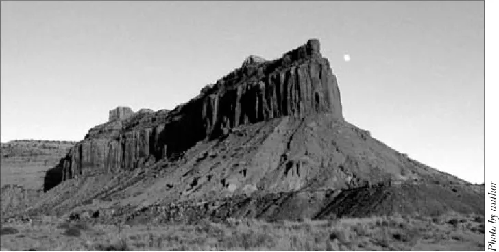
A close-up view of a sandstone butte near Canyonlands National Park seen by the Macomb Expedition and sketched by Charles Dimmock (see page 76).
![]()
ORGANIZING THE EXPEDITION
August 5, 1859. Camp No. 16 at the Rio Florida, 220 miles northwest of Santa Fé, New Mexico:
We have just heard rumors of a fight between our soldiers & the Mormons in the Salt Lake City—these rumors are brought in by Indian traders who came into our camp yesterday on their return from the great rivers we expect to visit—the reports are so extravagant we can scarcely believe them—they speak of battering down houses & killing women & children—so unusual a course for us that I cannot credit the reports—yet the description of the effects of the great guns so accurately given by the Indian reporters would seem to give a color of truth to the story after all—for without witnessing such scenes the Indians could hardly contrive such a story.1
So wrote Capt. John N. Macomb, Jr., to his wife, “Nannie,” as he led an Army exploring expedition into the wilds of Utah Territory.
In the years before Captain Macomb’s survey, Utah Territory was administered by federally appointed officials who frequently clashed with a powerful governor, Brigham Young, over Indian policies, mail contracts, land surveys, and probate courts. Since Young served also as the prophetic leader of the Church of Jesus Christ of Latter-day Saints, dubbed the Mormon Church, federal appointees feared the power he exercised. Furthermore, Utah’s populace overwhelmingly supported Young. Ultimately, open conflict intensified between federal and local officials and complaints reached Washington. In the spring of 1857, when James Buchanan became president, he acted on these complaints by sending an expeditionary force commanded by Albert Sidney Johnston to Utah to replace the governor and insure allegiance to federal authority.
During 1857–1858, the clashes between the United States and the Mormons, known as the Utah War, accelerated the exploration of the Mountain West by the Army’s topographical engineers. Historian C. Gregory Crampton wrote, “The success of the Mormon resistance to Johnston’s Army in 1857 and the logistical isolation of the federal troops at Camp Floyd [some forty miles from Salt Lake City] made it imperative that the War Department seek new supply routes into Utah.”2
Prompted by the conflict, the War Department directed the U.S. Army Corps of Topographical Engineers during the years 1857–1859 to survey the Mormon territory and find new approaches to Utah. They launched a three-pronged effort: From the Gulf of California Lt. Joseph C. Ives steamed up the Colorado River in the USS Explorer, a fifty-four-foot iron sternwheeler, to Black Canyon, where Hoover Dam now stands. Before turning back, he continued overland with a small party of men to explore the Grand Canyon. From Camp Floyd Capt. J. H. Simpson marched westward across the Great Basin to Genoa, Nevada, and beyond—on existing roads—over the Sierra Nevada Mountains to Placerville, near Sacramento. On the return march from Genoa he followed yet another path across the great interior basin, thereby discovering a shorter route to California, which the Pony Express and mail and stage lines would later follow. From Santa Fé Capt. John N. Macomb plotted a course into Utah’s canyon country and attempted to find a military route through the legendary sandstone labyrinth near the junction of the Green and Colorado rivers.
With their tents pitched in the San Juan River drainage along a wilderness trail, the men of the Macomb expedition, also known as the San Juan Exploring Expedition, seemed “inclined to believe” the reports that “our troops had bombarded Salt Lake City.”3 Though the reports later proved false, Macomb’s adventure into the West’s raw frontier moved forward.
Following the survey, Macomb commissioned a famous cartographer to create a map of the region his party explored. With the outbreak of the Civil War, the government delayed publication of the expedition’s report, which cost its members and its cartographer, the recognition due them. A number of biographies of the leading men still overlook the venture, or they ignore its important achievements.
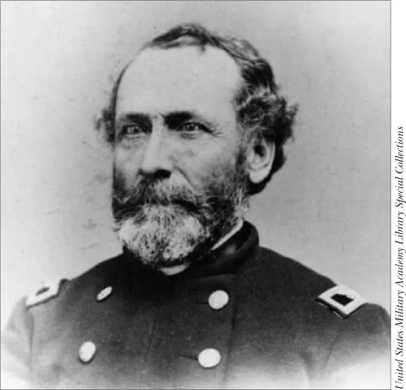
John N. Macomb, Jr.
The following narrative history represents the first detailed study of the Macomb expedition. Publication of this volume highlights the Macomb report’s beautiful color plates and the magnificent map of the region. It also features an interesting selection of the newly discovered official records, personal correspondence and diaries, raw pencil sketches, and other primary materials related to the frontier survey and its men. These documents provide fresh insights and new interpretations into the lives and contributions of Macomb and his companions.
In the course of their exploration of the West’s interior, the ambitious John S. Newberry launched a series of excursions to closely examine the region’s geography and natural history, particularly its paleontology, geology, and anthropology. As a civilian geologist, Doctor Newberry’s duties involved collecting scientific specimens, including zoological and botanical samples, for the Smithsonian Institution and providing a full report on the geology and mineralogy of the area. If necessary, he was required to supply medical and surgical attention to the men and to produce a report on the natural history of the region he examined. Determining the region’s natural resources for later exploitation by miners, cattle and sheep ranchers, railroaders, and settlers, was an implied task assigned to the team.
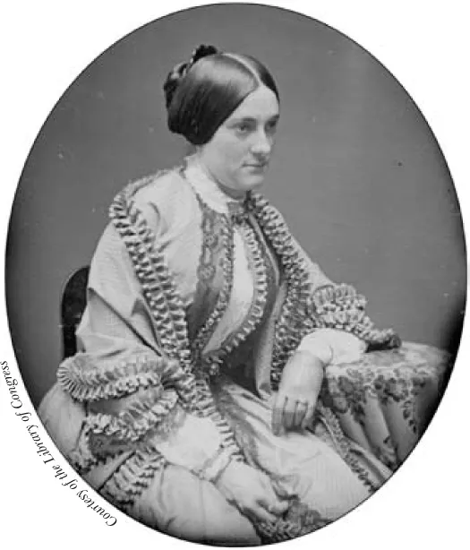
Ann Minerva “Nannie” Rodgers Macomb.
Just as Newberry made short jaunts to study the area, I make tangential journeys to depict more fully the activities and personal lives of Macomb and his companions. We will find an ambitious scientist and physician possessing great vision and intelligence and a tendency to see the beauty and potential in nature. We will also learn of the visual sensitivity of the expedition’s homesick topographer, who depicted wilderness scenes in pencil drawings and romantic word pictures. And we will discover both a loving family man and a task-oriented commander, with little imagination or landscape appreciation, who despised the desert Southwest.
Born April 9, 1811, in New York City, John Navarre Macomb, Jr., was the great grandson of Philip Livingston, a signer of the Declaration of Independence. In 1838, John married his cousin, Czarina Carolina Macomb, the daughter of General Alexander Macomb, Jr. She died in 1846. Four years later, he married Ann Minerva Rodgers, kin to a long military line. From the two marriages came eight children.4
Macomb launched his military career from West Point, where in 1832 he graduated from the military academy. That same year he served in the Black Hawk Expedition in the Midwest. Assigned to artillery units and engineering duty over the next several years, he rose through the ranks. Among his many duties, he made a hydrographic survey of the Straits of Detroit, took charge of seven military roads in Michigan, and made the preliminary surveys of the Manitou Islands and Grand Traverse Bay. Promoted to captain of the Topographical Engineers in 1851, he took charge of the survey of the northern and northwestern lakes. During that period, he began the survey of the Straits of Mackinac. Near the close of his surveys of the Great Lakes in 1856, the War Department assigned him to serve as the chief topographical engineer in the Military Department of New Mexico.5
The Army sent Macomb to New Mexico to replace a fiscally incompetent officer and repair the budgetary mess he had created. More importantly, the Army directed him to construct five vital military roads in the district. Macomb arrived in May 1857, and by July 1858 he had constructed and improved the “roads which formed the basis for New Mexico’s highway and railway system.” According to historian David Remley, Macomb’s work won the praise of the Santa Fé Gazette and of New Mexico’s governor. In addition, along the Taos to Santa Fé wagon route, the people of New Mexico erected a memorial pole in honor of Macomb, “who by aid of the government greatly improved the road.”6 In 1859, Macomb was a forty-eight-year-old career officer. His wife and family resided at 361 H Street in Washington, D.C.
Despite its military and political origins, the San Juan Exploring Expedition culminated in a quintessential scientific endeavor that collected rare and unique specimens for the Smithsonian Institution and made important contributions to America’s scientific foundation. With a prime objective “to examine especially . . . the region . . . traversed by the old Spanish Trail,” the reconnaissance would explore more than two hundred miles of the historic trace and fill a great gap in the geographical knowledge of the American West. Another important objective was “to fix also in position the lower portions and the mouths of the Green and Grand rivers”—to locate the junction of the Colorado and Green rivers.7
Until recently, the results of the Macomb expedition have remained largely ignored. The conditions of the Civil War delayed the publication of the final report for more than fifteen years. When issued in 1876 the report drew little public attention since America’s frontier exploration focus was set on the Great Surveys—those of Ferdinand V. Hayden, Clarence King, George M. Wheeler, and John Wesley Powell.
Nevertheless, the contributions of the San Juan Exploring Expedition deserve our attention. The Macomb survey eloquently described and splendidly illustrated its scientific work. The surveyors studied the region’s resources, assembled topographic information, and gathered important natural history specimens. Enraptured by spectacular landscapes and marvelous fields of archaeology, geology, and paleontology, the Macomb explorers poetically interpreted the frontier region transected by their team.
The expedition’s assistant topographer and geologist both were prone to adopt the nineteenth-century tendency to romanticize red rock erosion as cyclopean cities and Gothic cathedrals. However, they yielded to a stronger and more modern impulse for fact gathering, attention to detail, and astute observations of geologic wonders. The keen and often poetic observations of the geologist, the expedition’s key player, went beyond the typic...