![]()
1
Environments of Colorado
Mammals are a familiar and important component of Earth’s biodiversity. Biodiversity is the kinds of organisms and their genetic and ecological relationships—an evolutionary and ecological phenomenon in space and time (E. Wilson 1992). The mammalian fauna of Colorado is a fascinating piece of that whole. To understand the diversity of mammals we need to have a perspective of the ecosphere more generally. Such a perspective is the purpose of this chapter, with a focus on environments of Colorado.
Colorado is known for its scenic beauty—from majestic mountain peaks and rushing white rivers tumbling down dark canyons, to red-rock deserts and ceaselessly shifting sand dunes, to the expansive sweep of the short-grass prairie. Grandeur is wherever we stop to appreciate it, at every scale, from canyons carved in crystalline rocks 2 billion years old, to bold peaks sculpted by the glaciers of the last Ice Age, to last night’s furtive trail of a mouse across the snow. We humans appreciate ecological patterns and processes as beautiful or intriguing; to the rest of the mammalian fauna the evolving landscape represents opportunity, and native mammals respond accordingly. Thus, to understand the distribution and abundance of mammals and the details of their daily lives we must first understand the resource base, the mosaic of Colorado’s environments in space and time.
Geography
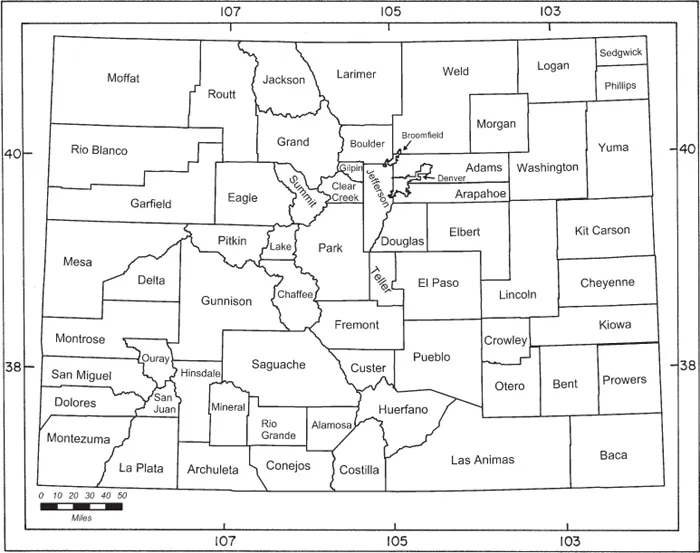
From the standpoint of political geography, Colorado is simple: it is roughly rectangular (if we neglect some minor old surveyors’ errors and the fact that Earth is spherical), measuring approximately 607 km by 444 km (377 by 276 mi.) and encompassing some 270,000 km2 (104,000 sq. mi.). Colorado lies between approximately 102° and 109° west longitude and 37° and 41° north latitude, and is subdivided into 64 counties (Map 1-1). A few of the counties are nearly natural, ecological units (e.g., Jackson, Grand, and Park counties encompass North, Middle, and South parks, respectively), but most are simply political artifacts with rectilinear boundaries.
MAP 1-1. Counties of Colorado.
From the standpoints of physical and biological geography, Colorado is anything but simple. The marvelous complexity of the scenery is the subject of this chapter, which describes environments of Colorado from several interrelated points of view. Geologic history and materials underlie environmental patterns. Physiography is the shape of the land, reflecting hundreds of millions of years of landscape evolution. Patterns of drainage reflect and produce the landforms. Vegetation integrates climate and geologic parent material in the development of soils. Plants and animals, fungi and microbes interact as biotic communities, integrated by symbioses, and they interact with the physical environment in ceaseless cycles of materials powered by a flow of solar energy. We observe—and seek to understand—an ecological whole of extraordinary complexity. But let us begin simply, with a little history.
Geology and Landforms
Colorado straddles the “backbone” of North America, the Rocky Mountains. From the mountain front, the Great Plains extend eastward toward the Missouri River. To the west lie canyons and plateaus of the Colorado Plateau and the Wyoming Basin. The juxtaposition of these major physiographic regions affects temperature, precipitation, wind patterns, and drainage.
Colorado is the highest of the United States, with a mean elevation of 2,070 m (6,800 ft.). The lowest point is 1,021 m (3,350 ft.), east of Holly, Prowers County, where the Arkansas River exits the state, and the highest point is 4,399 m (14,433 ft.), the summit of Mount Elbert, Lake County, at the top of the Arkansas watershed. Because of these varied conditions, species richness is high.
Physiographers divide most of Colorado among three “provinces” (see Fenneman 1931): the Southern Rocky Mountains, the Great Plains, and the Colorado Plateau. Northwestern Colorado is on the periphery of two additional provinces: the Middle Rocky Mountains and the Wyoming Basin. For an excellent summary of Colorado’s landforms and their development, see A. Benedict (2008).
The present-day Southern Rocky Mountains arose in a long-term event called the Laramide Orogeny, beginning some 72 million years ago, in the Late Cretaceous Period. Prior to that time (during the Mesozoic Era, the “Age of R...