![]()
Part 1
The Historic Ohio & Erie Canal
![]()
Chapter 1
The History of the Ohio & Erie Canal
SAM TAMBURRO
In the twenty-first century, it is difficult to grasp the significance of the canal era to U.S. and Ohio history. The period seems far removed, even quaint in its complexities. However, the canal system that developed in the nineteenth century created a commercial network that revolutionized trade and travel in the United States. Nowhere are these connections more evident than the nexus between New York’s Erie Canal and Ohio’s Ohio & Erie Canal.
The Ohio & Erie Canal and its link with the Erie Canal created an interrelated regional economy. Eastern seaboard farms could not compete with the fertile land of the Old Northwest. The reduced shipping costs provided by the canal systems enticed easterners to buy plentiful western agricultural produce because it was more economical than growing their own. And the Old Northwest, a rapidly developing area, provided an excellent market for manufactured goods. As a result, the East Coast began to focus on mass production of manufactured goods, and it had ample workforce numbers of displaced farmers to work in factories. A symbiotic production-consumption relationship was established between the two geographic areas.
The importance of an extension of the canal system into Ohio was not lost on the Erie Canal investors. A capital-impoverished frontier state in the early nineteenth century, Ohio turned to New York financiers to partially fund its internal improvement project. New York banking houses underwrote the initial $400,000 state bond issue. New York businessman John Jacob Astor also loaned the State of Ohio $1 million at 6 percent interest to support the Ohio & Erie Canal’s construction. It is clear that the New York business community understood the economic potential of Ohio and the Old Northwest, and they sought to capitalize on it through ground-level investment.
When the Ohio & Erie Canal groundbreaking ceremony occurred at the Licking Summit on July 4, 1825, it was not a coincidence that New York governor DeWitt Clinton, the “Father of the Erie Canal,” lifted the first spade of dirt. He also made a speech there that echoed the importance of a United States interconnected through internal improvements. Clinton boasted to the crowd: “See what my country has done in her juvenile state! And if She has achieved this gigantic enterprise in infancy, what will she not effect in the maturity of her strength, when her population becomes exuberant and her whole territory in full cultivation. And your sister states, and the civilized world, will be astonished.”1
The Ohio & Erie Canal’s connection with the Erie Canal influenced far more than the region’s economy. In the first half of the nineteenth century, Ohio’s population migration and settlement patterns, politics, social issues, architecture, and culture were all affected by the connectivity of the Ohio & Erie Canal. This is the historical context in which the Ohio & Erie Canal must be viewed. Subsequent chapters of this book explore many of these aspects of the canal in greater detail.
In 1818, Governor Ethan Allen Brown urged the Ohio legislature to begin surveys for canals from Lake Erie to the Ohio River, and with the passage of the Ohio Survey Law of 1822, several were conducted in the following years. The final route of the Ohio & Erie Canal combined parts of two of the originally proposed routes surveyed: the northern portion of the Cuyahoga-Muskingum line, and the southern portion of the Scioto Valley line. Beginning at Cleveland, the Ohio & Erie Canal ran down the Cuyahoga Valley to the Portage Summit, lifted by forty-two locks in thirty-eight miles to reach the summit at Akron, 395 feet above Lake Erie. From this point, the canal followed the Tuscarawas Valley south to Roscoe Village, where the Tuscarawas River joins the Walhonding River to form the Muskingum River.2 From here, the canal turned to the west toward the center (and the capital) of the state, and the Licking Valley. In this stretch, several aqueducts, feeders, and reservoirs were needed to engineer the canal through the topography. South from Columbus, the canal followed the Scioto River Valley to Circleville and Chillicothe, to the terminus at Portsmouth.
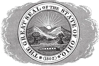
Early versions of the state seal depicted a canal boat (Henry Howe, Historical Collections of Ohio).
Ground was broken on July 4, 1825, and by July 4, 1827, the northern section between Cleveland and Akron was completed. Alfred Kelley, attorney and former mayor of Cleveland, served as acting commissioner on the northern section of the canal, which encompassed the canal north of Newark. The engineering of the Ohio & Erie Canal was patterned after that of New York’s Erie Canal. The canal’s prism was forty feet wide (at water level) and four feet deep, and its locks were ninety feet long and fifteen feet wide. Many of the canal’s initial engineers came from New York, but locals quickly filled additional positions.
Several Ohio engineers directed the large construction project, including Francis Cleveland, Jessie L. Williams, and Richard Howe. In 1825, Howe was appointed resident engineer on the northern division of the canal, which stretched from Cleveland to Massillon, and served in that position until the 1850s. Resident engineers, like Howe, were responsible for directing the labor force. Howe built his home in downtown Akron; involved in civic activities in Akron, Howe proved to be instrumental in politicking for Akron to be the western terminus of the Pennsylvania & Ohio Canal, a feeder canal connecting with the Pennsylvania Mainline Canal in New Castle, Pennsylvania. His home still stands in downtown Akron and is being restored by the Ohio & Erie Canalway Coalition. Jack Gieck, canal historian and engineer, gives a full discussion of both the engineers and the engineering of the canal in chapter 2.
Immigrants, especially Irish and German, provided the bulk of the labor on the construction of the Ohio & Erie Canal. However, many local farmers joined the construction ranks during winter. At times the state also used convict labor—for instance, in 1827 Ohio released a number of prisoners from its state penitentiary to build the Columbus Feeder.3 Dangerous working conditions and illness characterized the job. Historian Peter Way notes that in the summer of 1825, typhoid broke out among Ohio canal laborers digging the basin at Cleveland; the disease spread down the Cuyahoga Valley and resulted in seventeen deaths.4 The role of the common laborer and more on immigrant history are discussed by George Knepper in chapter 3, Kathleen Fernandez in chapter 6, and Lynn Metzger in chapter 15.
Completed in 1832 and stretching 309 miles from Cleveland to Portsmouth, the infrastructure of the Ohio & Erie Canal system was substantial. The canal maintained approximately 151 lift locks and 7 guard locks, 23 aqueducts, and numerous ancillary structures such as towpaths, waste weirs, floodgates, and wasteways. The total cost of the Ohio & Erie Canal was $4.3 million, making it less expensive than any other canal of similar length in America.5 The state funded the canal’s construction by having Canal Fund Commissioners sell bonds to banking houses in Ohio, New York, and Europe. Additional funding for the project came from the federal government through land grants: 1,100,351 acres of federal land were given to the State of Ohio for canal use. This land was sold at two dollars per acre, and the proceeds used for the construction of the canal. The U.S. government made the grant on the condition that it would never be charged a toll for use of the canals.6
The pace of life in Ohio changed significantly after the opening of the Ohio & Erie Canal. Travelers on the canal were able to cross the state in approximately eighty hours, a dramatic improvement over a trip by horseback. However, it would be a mistake to characterize canal travel as luxurious or romantic. Most travelers found canal travel monotonous because of the lack of an appealing view: generally, packet boats sat below the level of the towpath, and the canal banks were covered with thick vegetation.7 In addition, the accommodations on canal boats left much to be desired.
George Combe, a visitor from England in 1838, described his sleeping quarters in disturbing detail. He writes: “The beds were arranged in three tiers along the walls. During the day the beds, consisting of mattresses, sheets, pillows, and cotton quilts, were piled one above another. . . . The smell of animal effluvia, when they were unpacked, was truly horrid . . . they [the beds] were saturated with the perspiration of every individual who had used them since the commencement of the season, or probably from the time they were first taken on board.”8
A few travelers, such as Maximilian, Prince of Wied, recorded their journeys in great detail. Chapter 5, by Joseph T. Hannibal, Sabina F. Thomas, and Michael G. Noll, presents a new translation of Prince Maximilian’s journey on the Ohio & Erie Canal. Such observant travelers also left a valuable record of what the Ohio region’s natural history was like at the time. See Joe Hannibal’s chapter 4 for a clear and detailed look at that natural history.
Canal travel was also unpredictable. A heavy rain could rupture an embankment, leaving a canal dry for long periods. Because canals were artificial, self-contained waterways, there was little drainage or circulation of water. As a result, water often became stagnant. Poorly drained places like canals were collectively recognized as unhealthy. One traveler described the Ohio & Erie Canal: “Carrion often float on the surface [and] miasmata are generated, all which must render a residence near the bank unhealthy. It is in fact a nursery of fever and ague.”9
Nonetheless, eastern settlers and new immigrants boarded canal boats to migrate to Ohio for a better life. U.S. Census statistics confirm that after 1820 significant population growth occurred in counties through which the Ohio & Erie Canal passed. Until the canal’s completion, the state’s principle population centers were located in or near the Ohio River Valley. By 1850, there was a definite immigration pattern in Ohio related to the Ohio & Erie Canal: counties that the canal bisected had higher populations of foreign immigrants than others in the state.10 Glenn Harper takes a fresh look at these settlement patterns and the resulting architecture and landscape of the canal region in chapter 11.
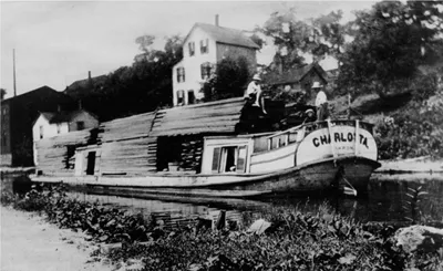
Lumber was an important product hauled on the canal (Historic Print Collection, National Park Service).
The Ohio & Erie Canal rapidly transformed the economy of Ohio. It carried more trade than any other internal Ohio waterway. In 1851, the zenith of the canal’s operation, 2,529,342 bushels of wheat arrived at Cleveland, and 645,730 barrels of flour, 1 million bushels of corn, 3 million bushels of coal, and 11 million pounds of merchandise were shipped south. According to Ronald E. Shaw’s Canals for a Nation, more grain came into Cleveland from the interior of the state than from the Cuyahoga Valley or the Lake Erie shore.11 Much of the wheat and flour came from the Scioto, Muskingum, and Tuscarawas River Valleys. John G. Clark, in his book Grain Trade in the Old Northwest, argues that wheat and flour exports from Newark, Dresden, Roscoe, Dover, Massillon, and Akron constituted almost all of the receipts in Cleveland. Akron served as a regional milling center and milled most of its wheat into flour, sending 376,000 barrels of flour to Cleveland in 1846 and 1847.
As a result of the Ohio & Erie Canal opening, the state’s farming economy rapidly evolved from a subsistence- to a market-based one. The Ohio & Erie Canal’s role in the facilitation of the market revolution in the U.S. economy during the early part of the nineteenth century cannot be understated.12 Similar to New York’s Erie Canal, the Ohio & Erie Canal played a significant role in the establishment of a market economy by providing a mechanism (improved transportation) for specialized production and economies of scale based on comparative advantage, setting the stage for the Industrial Revolution. As canal historian Jack Gieck has pointed out, by the mid-nineteenth century, the Ohio & Erie Canal had transformed Ohio from an agrarian frontier wilderness into a prosperous agricultural and industrial commonwealth.13
The opening of the O...