- 248 pages
- English
- ePUB (mobile friendly)
- Available on iOS & Android
eBook - ePub
About this book
Gender inequality is entrenched in the cultural, political and market systems that operate at household, community, and national levels. Global changes in market access, climatic conditions, and the availability of natural resources intensify disparities in income, in assets and in power among genders. This book aims to explain these gender dynamics at macro and micro levels through GIS and spatial analysis. The first part of the book introduces key concepts of how to integrate GIS in gender inequality research. The second part presents more in-depth case studies, carefully selected such as mapping gender-based violence, gender-inequality in the labor force, refugee mapping, etc.
Trusted by 375,005 students
Access to over 1.5 million titles for a fair monthly price.
Study more efficiently using our study tools.
Information
1
The Global Problem in Gender Inequality: Putting Gender on the Map with GIS
Esra Ozdenerol
CONTENTS
The Global Problem in Gender Inequality
Conclusion: Gender Equality Cannot Wait!
References
Resource Guide of Organizations that Provide Gender Indicator Data
UN Gender Statistics
United Nations Development Program
UNdata
UNWomen
GHO – Global Health Observatory Data
Family Planning 2020
Girls Not Brides
#MeToo movement
Population Council
Save the Children
MAP-Movement Advancement Project’s Equality Maps.
This chapter introduces gender in Geographic Information Systems (GIS) and explains the substantial potential that GIS holds for supporting efforts to end gender inequality and put gender on the map. Though the role of GIS in gender study is new, GIS can serve to illustrate distribution and access to resources, which can contribute toward the solution of socio-economic issues and the reduction of disparities between men and women while also advancing LGBTQ rights. GIS has characteristics inherent in its structure such as data collection and representation that make it possible to produce gendered knowledge. By definition, GIS is a framework for gathering, managing, and analyzing data (Cromley 2003). Rooted in the science of geography, GIS integrates many types of data. It analyzes spatial locations and organizes layers of information into visualizations using maps and scenes. With this unique capability, GIS can reveal deeper insights into gender data, such as patterns, relationships, and situations. This process starts with the research questions we ask, moves into the data we collect, and is finalized in the graphic representations we produce. While there is currently a lack of gender data readily available for spatial analysis, awareness of the issue and demand for data will bring necessary information forward with the goal of putting gender on the map. GIS scientists contribute to gender inequality research by teasing out the connections between place and inequality and by utilizing GIS tools and spatial methodologies to explore these associations. Inventive new tools for analysis, big data, and open data platforms provide a strong foundation for innovative place-based gender inequalities research. In summary, applications that utilize GIS and spatial methodologies enhance the measurement of place characteristics and the assessment of their associations with gender inequalities.
First and foremost, GIS has the power to aid and influence international development work by combining different datasets into one visual image. Integrating statistical geospatial data with socio-economic information and analysis and mapping indicators of development from district to country level facilitate the assessment of progress and gaps across all Sustainable Development Goals (SDGs) of the 2030 Agenda (UN 2019). A hallmark of the 2030 Agenda is that it applies to all countries, all people, and all segments of society, while promising to prioritize the rights and needs of the most disadvantaged groups, from access to education and health care to clean water and decent work. The spread of information and communications technology and global interconnectedness has great potential to accelerate human progress, to bridge the digital divide, and to develop knowledge societies, as does scientific and technological innovation across areas as diverse as medicine and energy. GIS analysis and mapping of gender inequality indicators reflect the realities of the lives of women and men and describe the roles of women and men in the society, economy, and family. This can be utilized to formulate and monitor policies and plans, monitor changes, and inform the public.
The online GIS platform is used to establish a comprehensive mapping of, and serve as a gateway for, information on existing science, technology, innovation, initiatives, mechanisms, and programs. There is a range of practical online/mobile interactive GIS maps, dashboards, and applications. Some of these dashboards and applications receive data updates in near-real-time. The online GIS platform facilitates access to information, knowledge, and experience, as well as the best practices for science, technology, and innovation facilitation initiatives and policies. The online platform also facilitates the dissemination of relevant open access data generated worldwide. Figure 1.1 is an example of an online GIS dashboard of Covid-19 cases in the context of gender inequalities and women’s health care needs in the world. As GIS depicts spatial patterns in gender-related data, issues and trends such as fertility rates, literacy rates, and population density are revealed, and gender inequality index and other development indexes for countries and districts can be mapped. The countries and districts are then ranked in order of most to least developed. With GIS, key issues can be quantified and investigated more effectively. Spatial patterns in socio-economic data at finer scales, such as at the district level, also reveal issues and trends that would otherwise be missed by data aggregation by political or other units.
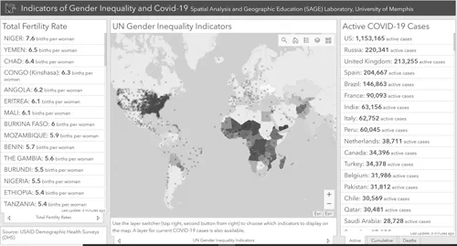
A screenshot of an online GIS dashboard of Covid-19 and Gender Inequalities (Source: Spatial Analysis and Geographic Education Laboratory, University of Memphis, https://cpgis.maps.arcgis.com/apps/opsdashboard/index.html#/f4000bb07cfc4ba4989fa72e1d056b6c).
Since the 1990s, development interventions have been formulated and implemented in an integrated manner using GIS. The later invention of cloud and mobile technology has added district-level digital datasets of development regions and has facilitated wider dissemination of GIS data, technology, and applications. For example, the MENRIS (Mountain Environmental and Natural Resource Information Service) database is developed by a decentralized network of institutions to facilitate environmental and natural resource planning, monitoring, and management among several mountain nations including Nepal, Bhutan, India, Pakistan, China, Bangladesh, and Myanmar. This enlightens the region with new technological innovation in information sciences and enables the collection, storage, and dissemination of key biophysical and socio-economic data at national and district levels. MENRIS case study series are published and distributed to facilitate wider dissemination of GIS technology and applications (Murai and Singh 1998). This project uses a breadth of variables such as literacy rates, population density, agricultural credit, and slope steepness to construct a development index for each district.
An integrated approach to addressing gender inequity and making use of the opportunities for development should have a strong database and an appropriate methodology for analysis. There are many challenges, however, to operationalizing a methodological approach that captures the intersection of different forms of discrimination and inequities. These challenges include data limitations and identifying which forms of discrimination are relevant in each context. Wealth and income-based discrimination are understood to be relevant across countries, but other forms of discrimination are more context-specific per country and/or region in a country. For example, land distribution translates into economic disparity. GIS is used for securing land rights across the world today. In Tanzania, under the Evaluation, Research and Communication (ERC) project, the USAID (United States Agency for International Development) piloted a project to crowd-source land rights information at the village level using mobile technology. The Mobile Application to Secure Tenure (MAST) project supported identified needs of the Government of Tanzania to improve land governance and lower the cost of land certification programs (USAID Land Projects 2016). The mobile platform technology was able to map a community’s land of 1,000 plots in four weeks. The immediate result of this was that women went from having no land ownership to boasting of 40% of the land. Another 30% of the land went under joint titling, and the remaining 30% under male ownership. It is a right that people had never had before. Formal land administration systems (LAS) in developing countries have generally not met the need for accessible, cost effective, and appropriately nuanced land registration. As a result, large majorities of rural dwellers (and many urban dwellers) live without formalized rights to land and other valuable resources. This lack of documentation may constrain the ability of individuals and communities to leverage their land-based assets for improved economic outcomes, to limit environmental har...
Table of contents
- Cover
- Half-Title
- Title
- Copyright
- Dedication
- Contents
- Foreword
- Preface
- Acknowledgments
- Editor Biography
- List of Contributors
- 1 The Global Problem in Gender Inequality: : Putting Gender on the Map with GIS
- 2 Mapping Domestic Violence
- 3 Geospatial Approaches to Intimate Partner Violence
- 4 Gender Disparity and Economy in U.S. Counties: Change and Continuity, 2000–2017
- 5 Social and Environmental Injustice Experienced by Female Migrant Workers in China: : The Case of Guiyu Town
- 6 Spatial Concentration of Social Vulnerability and Gender Inequalities in Mexico
- 7 The Evolving American Opioid Crisis: : An Analysis of Gender, Racial Differences, and Spatial Characteristics
- 8 How to Undertake an Inequality, Gender and Sustainable Development Analysis: : A GIS Approach to Gender Analysis in Pakistan
- 9 Visualizing Equality in the New Mobility Workforce
- 10 Spatial-Temporal Patterns of Gender Inequalities in University Enrollment in Nigeria: 2005–2015
- Index
Frequently asked questions
Yes, you can cancel anytime from the Subscription tab in your account settings on the Perlego website. Your subscription will stay active until the end of your current billing period. Learn how to cancel your subscription
No, books cannot be downloaded as external files, such as PDFs, for use outside of Perlego. However, you can download books within the Perlego app for offline reading on mobile or tablet. Learn how to download books offline
Perlego offers two plans: Essential and Complete
- Essential is ideal for learners and professionals who enjoy exploring a wide range of subjects. Access the Essential Library with 800,000+ trusted titles and best-sellers across business, personal growth, and the humanities. Includes unlimited reading time and Standard Read Aloud voice.
- Complete: Perfect for advanced learners and researchers needing full, unrestricted access. Unlock 1.5M+ books across hundreds of subjects, including academic and specialized titles. The Complete Plan also includes advanced features like Premium Read Aloud and Research Assistant.
We are an online textbook subscription service, where you can get access to an entire online library for less than the price of a single book per month. With over 1.5 million books across 990+ topics, we’ve got you covered! Learn about our mission
Look out for the read-aloud symbol on your next book to see if you can listen to it. The read-aloud tool reads text aloud for you, highlighting the text as it is being read. You can pause it, speed it up and slow it down. Learn more about Read Aloud
Yes! You can use the Perlego app on both iOS and Android devices to read anytime, anywhere — even offline. Perfect for commutes or when you’re on the go.
Please note we cannot support devices running on iOS 13 and Android 7 or earlier. Learn more about using the app
Please note we cannot support devices running on iOS 13 and Android 7 or earlier. Learn more about using the app
Yes, you can access Gender Inequalities by Esra Ozdenerol in PDF and/or ePUB format, as well as other popular books in Social Sciences & Gender Studies. We have over 1.5 million books available in our catalogue for you to explore.