![]()
CHAPTER 1
Volcanoes, God, and Coconuts
A FEW WEEKS AFTER the Pacific war began, newspaper correspondent George H. Johnston posed a rhetorical question about Rabaul: “Why are the Japs striking at this little tropical outpost less than five degrees below the equator?”
The short answer is that Rabaul boasts one of the finest harbors in the Pacific. Its numerous deepwater anchorages are ringed by rugged mountains, with a relatively narrow passage in the southeast quadrant that opens to the sea. The main basin, measuring approximately seven-and-a-half miles long by five miles wide, is surrounded with volcanoes that stand shoulder to shoulder like sentinels. They are magnificent reminders of the extreme geological violence that formed the landscape and its anchorage.
Located at the northeastern tip of crescent-shaped New Britain, largest of the more than two hundred islands that make up the Bismarck Archipelago, the town of Rabaul sits atop a seismic time bomb. This is largely because Rabaul lies within a huge circular fault line—a geological phenomenon known as a ring fracture—which defines a fragile, loose-fitting lid over a subterranean chamber of magma. The ground is highly unstable. Rabaul is shaken routinely by earthquakes—a hundred per month is not unusual—and during “crisis periods” of heightened seismic activity, they sometimes come in swarms. During the mid-1980s, for example, Rabaul was rocked by tens of thousands of quakes, with one extraordinary spike of nearly fourteen thousand measurable tremors in a single month—an average of well over four hundred quakes per day.
For all the excitement they cause, the earthquakes that rattle New Britain are not particularly damaging. The inherent danger lies in the potential of the ring fracture to violently erupt. More than thirty such events have occurred in just the past five hundred thousand years, some lasting for days or even weeks as enormous amounts of magma burst from the ring fracture. In several cases, so much material was ejected from the magma chamber that the loose-fitting lid above it collapsed like a soufflé. With each subsequent eruption the depression grew larger, and is known today as the Rabaul caldera. TheSpanish word for caldron, it is an appropriate description indeed.
One of the most devastating volcanic events occurred a mere 1,400 years ago. In the estimation of Dr. C. Daniel Miller, a volcanologist with the U.S. Geological Survey, “a very violent eruption” ejected approximately ten cubic kilometers of magma and debris from the subterranean chamber. The amount of destructive force necessary to blast so much material from the earth is almost inconceivable. “It would be like hundreds of H-bombs going off—one every thirty seconds for ten hours,” says Miller. “That’s the kind of energy we’re talking about.”
The subsequent collapse of the empty magma chamber must have been spectacular, but there was no one alive to see it. Virtually every human being within thirty miles of ground zero had been killed, including those on nearby islands. One can only imagine the stupendous sight as twenty square miles of terrain suddenly dropped six hundred feet or more. That event was followed by flooding of biblical proportions as the ocean poured through a breach in the southeastern quadrant of the depression. Once the dust settled and the waters calmed, the result was a large basin of seawater surrounded by a bizarre moonscape of pumice and ash.
Thanks to the tropical climate with its copious amounts of annual rainfall, the volcanic soil was covered by fast-growing kunai grasses and other vegetation in a relatively short time. Native islanders eventually returned to the area, building new villages and resuming the familiar patterns of their ancestors. They tended gardens, defended their villages, and practiced the timeworn rituals passed down from generation to generation. For the next thousand years, the giant caldera remained silent, and eventually the great eruption was forgotten.
THE FIRST KNOWN European to sail completely around the crescent-shaped island, English explorer William Dampier, arrived in 1700. He named the island New Britain and charted its coastline, but for many years thereafter, explorers avoided the island because of justifiable fears of malaria and cannibals. Seafarers may have anchored in the caldera on rare occasions, but their shore parties did not stray far from the beach. For the next 150 years, the island remained shrouded in obscurity.
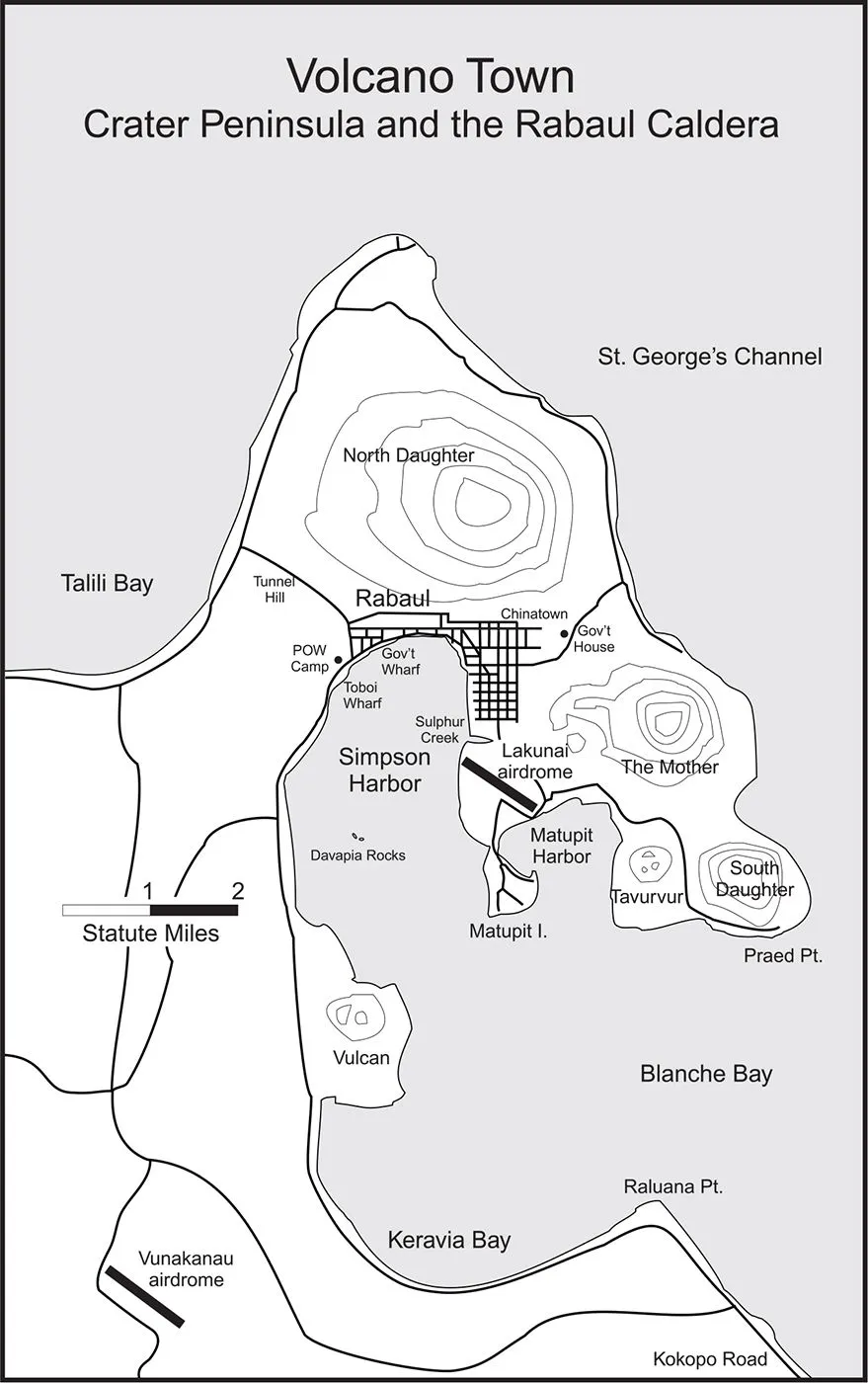
By the mid-nineteenth century, much of the fear associated with headhunters and malaria had been overcome by the inexorable spread of Christianity. After bringing the gospel to Polynesia, white missionaries headed for Melanesia, the “black islands,” with noble ideas of turning the savages into children of God. In 1872, Capt. Cortland Simpson of the Royal Navy sailed HMS Blanche into the caldera and claimed its “discovery.” He named the inner harbor for himself and the outer bay for his ship, thus adding Simpson Harbor and Blanche Bay to the nautical charts. Contrary to Simpson’s claim of discovery, the caldera had been mapped a full century earlier by another English explorer, Philip Carteret, who had named the volcanic mountains surrounding the basin. The largest was the North Daughter, soaring 1,600 feet above Simpson Harbor; the South Daughter anchored the southeastern tip of the volcanic peninsula; and the Mother stood between them, her twin peaks resembling breasts.
After Simpson’s visit, dozens of traders and missionaries began to settle New Britain, and its population steadily increased throughout the late 1800s. Competition between Catholic and Protestant missionaries sometimes confused the natives, but the practices of headhunting and cannibalism gradually waned. Interestingly, the Christians failed to change the islanders’ beliefs in the supernatural. Thanks to the earthquakes (gurias in the native Tolai language) that shook New Britain almost daily, the islanders were convinced that malevolent spirits called kaia inhabited the volcanoes. Some of the big mountains were long extinct, but there was still plenty of volcanic activity. In 1791, English explorer John Hunter observed a vent near the South Daughter erupting a large column of steam; and sixty years later another eruption occurred along an odorous gully known as Sulphur Creek, which empties into Simpson Harbor.
There was nothing supernatural about the eruptions, of course. Hot magma still occupied the subterranean chamber, which alternately swelled and contracted over the centuries. One odd-looking result, the Davapia Rocks, protruded like obelisks from the middle of Simpson Harbor. Locals called them “the Beehives.” A mile to the east stood another geological phenomenon, Matupit Island, which had risen from the caldera like a blister until it reached more than thirty feet above sea level. Nearby squatted an ugly, menacing volcano named Tavurvur, which Hunter had witnessed erupting in 1791. Yet another volcano, Rabalanakaia, was nestled in the shadow of the Mother, which in turn was flanked by the North Daughter and South Daughter, and at least three unnamed vents lined the banks of the aptly named Sulphur Creek. With so many different vents and fumaroles present, the finger of land around Simpson Harbor and Blanche Bay became known as Crater Peninsula.
COMPARED WITH THE influence of Christianity and even the awesome power of volcanoes, nothing changed New Britain like the humble coconut. In the mid-nineteenth century, coconut oil gained popularity as a key ingredient in candles and soap. German companies perfected methods of cutting up coconuts and processing the meat, which was then packed in burlap bags and shipped to the Fatherland, where factory presses extracted the oil. Thus was born the copra industry. Plantations sprang up all across the Pacific, and the volume of shipping traffic exploded. New Britain was no exception. The industry expanded rapidly throughout the archipelago, claimed by Germany as a protectorate in 1884 and named after the first chancellor, Otto Von Bismarck. A year later, Germany annexed a large portion of eastern New Guinea (the Netherlands claimed the western half, calling it Dutch New Guinea, while Great Britain claimed the southeastern portion, including much of the Papuan Peninsula). The privately held New Guinea Company received a charter to administer the territory, but rampant malaria forced the company to move its headquarters to New Britain.
The administration settled at Kokopo (pronounced Cocka-pō), a community on the shore of St. George’s Channel. The choice was influenced by the town’s proximity to Vunapope (Vuna-pōpay), the regional center for the Order of the Sacred Heart, a Roman Catholic organization. Easily the largest mission on New Britain, Vunapope occupied a handsome, sprawling campus overlooking the sea. As a location for the territorial headquarters, however, Kokopo proved to be undesirable, mainly because its harbor was inadequate for large ships.
In the early 1890s, the German government took over the administration of the protectorate and sent Dr. Albert Hahl to serve as its first governor. Eager to move the headquarters into the protected waters of Simpson Harbor, Hahl acquired the swampy land at the north end of the anchorage in the name of the government. The area had been deemed unsuitable for development, but with efficient German engineering the mangrove swamps were drained and cleared, a wharf was constructed in 1904, and the first buildings were erected the following year. Tram lines were laid to move goods from warehouses to wharves on narrow-gauge carts, and the Germans even cut a tunnel through the side of the caldera to reach a village on New Britain’s north shore.
By 1910 the territorial government was established in the new town, named Rabaul, meaning “place of mangroves.” It featured wide boulevards and hundreds of shade trees, a bustling commercial district, and attractive bungalows along the pleasant side streets. Hahl resided in Government House, an impressive mansion on Namanula Hill. Nearby was a modern hospital, raised on piers so that air could circulate underneath, and surrounded by deep verandas that took advantage of the hilltop’s pleasant sea breezes.
Rabaul and its superb anchorage soon gained favor as a shipping port. Entrepreneurs arrived from Europe and Asia, bringing more sophistication to the tropical town. A few years after this idyllic start, however, World War I interrupted progress. The British Admiralty, concerned that Germany would send commerce raiders into the Pacific, appealed to Australia for help in capturing key ports and other installations in German New Guinea. The Royal Australian Navy responded by sending an expeditionary force, which arrived at Rabaul on September 11, 1914. Troops went ashore that afternoon to search for wireless stations, and one platoon met stiff resistance en route to Bita Paka, where the Germans had erected a giant steel radio mast. Five Australians were killed in action—the Commonwealth’s first casualties of World War I—but the transmitter was successfully captured. The Aussies occupied Rabaul without a fight the next day, and four days later Germany surrendered the entire territory.
For the duration of the war and two years thereafter, the Australian Army maintained martial law over the captured region. The League of Nations granted portions of the former German territory to the Commonwealth in 1921, at which time the acquisition was renamed the Mandated Territory of New Guinea. Scattered among its hundreds of inhabited islands were innumerable native villages, coconut plantations, and mission stations with an eclectic mix of residents. The biggest islands featured coastal towns with bustling waterfronts, such as Kavieng at the northern tip of New Ireland.
By the mid-1930s, Rabaul was well established as the largest and most cosmopolitan town in the territory. Its citizens shopped at department stores operated by some of Australia’s biggest trading conglomerates, including Burns, Philp & Company and W. R. Carpenter & Company. Rabaul boasted a movie theater, a library, a book club, social clubs, pharmacists, a printing office, taxi stands, pool halls, gas stations, and an ice-making and cold storage plant. Among the sporting venues were a large concrete swimming pool, a cricket field, a baseball diamond, and even a golf course. There were also two airdromes: Lakunai, about two miles southeast of Rabaul along the shore of Simpson Harbor, and Vunakanau, eleven miles south of Rabaul, used by the RAAF as a forward operating base. Near the outlet of Sulphur Creek in Simpson Harbor, a seaplane terminal and ramps were built for Queensland and Northern Territory Aerial Services (QANTAS), the oldest airline in the English-speaking world. Thus, George Johnston’s description of Rabaul as a “little tropical outpost” was misleading. By the start of World War II, Rabaul was a bustling town with well over three hundred permanent buildings and a population of approximately one thousand Caucasians, three thousand Asians, and six thousand Melanesian islanders.
In many ways Rabaul was a pleasant tropical town, but its habitability was severely tested one Saturday afternoon in the spring of 1937, when a harmless-looking islet near the western shore of Simpson Harbor suddenly erupted. Compared with the cataclysmic event that had occurred some 1,400 years earlier, this eruption was small, disgorging perhaps half a cubic kilometer of ejecta. But even a small eruption near a populated area can be both terrifying and devastating. In this case, a dark column of smoke and debris exploded from the vent. Flashes of lightning darted almost constantly from the volcanic cloud, and thunder added its din to the roar of the eruption. Muddy seawater, sucked into the cloud by convection, fell to the ground in torrents of dirty rain. The biggest disaster occurred when the outer portions of the eruption column collapsed, producing a pyroclastic avalanche that wiped out two Tolai villages and incinerated five hundred natives.
As the eruption gained strength, heavy ash began to fall downwind. The citizens of Rabaul, having dropped whatever they were doing to watch the spectacle, suddenly realized they were in the path of the fallout. Only two roads led north out of the caldera, both of which became jammed with thousands of refugees. Daylight turned to night as the thick, gray clouds overtook them, and the booming of thunder made it seem as though doomsday had arrived.
Sunrise the next morning revealed an amazing sight. The small islet in Simpson Harbor had been transformed overnight into a conical mountain more than seven hundred feet high. A wisp of steam drifted from its cone, but the eruption was over. Later that afternoon, the squat volcano named Tavurvur erupted with its own blast of steam and heavy smoke. The flaming debris was frightening to behold, but the eruption soon subsided. Rabaul was abandoned for two weeks, its once-lovely streets in ruins. Trees had snapped under the weight of several inches of wet ash, cars lay buried as though by a gray blizzard, and ships were aground, scattered at odd angles on the beaches. The task of cleaning up was a long and frustrating affair.
In the wake of the devastating eruption, the Australian government decided to move the capital of the mandated territory elsewhere. But the only viable alternatives were on the malaria-ridden coast of New Guinea, and two years of bickering ensued. Eventually the town of Lae, known as the site where Amelia Earhart and Fred Noonan began the last leg of their ill-fated attempt to cross the Pacific, was selected as the future capital. Before an official move could begin, however, Adolf Hitler launched his blitzkrieg on Western Europe. With that, Rabaul was all but forgotten as the Australian government turned its attention to the war on the other side of the globe.
![]()
CHAPTER 2
24 Squadron
IF THE UNITED STATES WAS said to be “a sleeping giant” at the onset of World War II, Australia was nearly comatose.* The Commonwealth was still in dire economic straits in 1941, thanks to a painfully slow recovery from the worldwide economic depression of the previous decade. Australia was neither wealthy nor powerful, and a large percentage of its economy and military strength went to support British interests. Tens of thousands of its soldiers were sent to North Africa to fight the Germans, such that by the end of 1941 almost three whole divisions had been committed. As a result, Australia lacked adequate manpower to defend her own backyard. Her weakness was sharply criticized in official postwar assessments, which lamented the Commonwealth’s tiny navy, lack of weapons and supplies, and an air defense that was hardly more than “a paper plan.”
Almost twenty years earlier, the Royal Geographical Society had warned against the dangers of one country gaining control over the Pacific. After visiting several island groups of Australia’s mandated territory in 1921, the Honorable J. P. Thomson had written: “On each of these groups enumerated a naval base could be established and its position rendered secure against attack by suitable fortifications and the natural advantages afforded by the coral-reef structures. Once this was done a hostile power would be in a position practically to dominate the whole of the Pacific Ocean. With submarines and a fleet of destroyers, it would be a simple matter to isolate Australia and New Zealand.”
Thomson’s assessment was remarkably prophetic, but the Allies failed to pay attention. Canberra seemed more interested in the gold fields of New Guinea until World War II began, when the military importance of the mandated territory was finally addressed.
The first noteworthy effort to link the islands with a communications network was achieved by Lt. Cmdr. Eric N. Feldt of the Royal Australian Navy, who set out in the fall of 1939 to enlist as many men as possible in a coastwatching organization. Traveling from island to island between New Guinea and the New Hebrides, Feldt enrolled dozens of plantation owners, traders, government officials, and other civilians into a loosely organized group. His achievement was brilliant: in the coming years the scattered coastwatch...