Geology of the Great Basin is the essential introduction to the geology of this physically complex, ever-changing region. Written in a clear, succinct style and generously illustrated with photographs, diagrams, and maps, the book describes the fundamentals of geologic processes, then discusses the physical attributes and geologic history of the Great Basin. The author also offers readers information about specific sites where significant geologic features can be observed. The book, first published in 1986, is now available in a new, easier-to-handle paperback edition that will make it more convenient for classroom use and for readers who want to carry it with them in their car or backpack.
- English
- ePUB (mobile friendly)
- Available on iOS & Android
eBook - ePub
Geology of the Great Basin
About this book
Trusted by 375,005 students
Access to over 1.5 million titles for a fair monthly price.
Study more efficiently using our study tools.
Information
PART I
ROCKS, CONCEPTS, AND PROCESSES
1
INTRODUCTION
The dry sand stretches away as far as I can see to the east and the west. The July sun burns a hole in the sky and sears the desert basin. Shimmering heat waves ripple the sand at the horizon and make the reflections of the mountains flicker upside down on the pseudoliquid surface. The sandy mud has shrunk and cracked since the last summer rain and has formed polygonal fractures in the barren brown surface. These are the only marks on the sand. One hundred years ago, feet and ironbound wooden wheels churned the dust of this desolate sandy valley. Emigrants, bound for Oregon, took a shortcut across this forsaken stretch. It was a dash across the sand before the sun parched their tongues black with thirst and shriveled the stock to walking skeletons, or before the sky blackened with the rare but fatal summer rain that would flood the dust-covered basin with water and turn the silts to viscous mud. With wagons mired up to their axles, the emigrants foundered in a sea of muck.
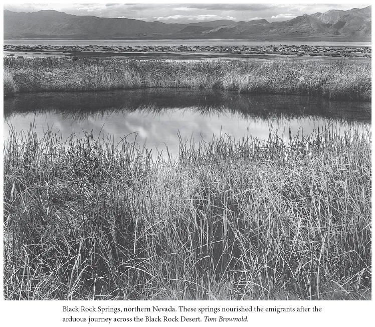
Here, in the Black Rock Desert of what would become northern Nevada, the emigrants would watch for a large dark knob across the shimmering sands and beeline straight for it. Below this black rock and slightly to the north is Double Hot Springs. Here the parched people and stock would find boiling hot water, confirming the devil’s role in fashioning this land. Downstream, where the water had cooled sufficiently to allow the growth of thick mats of grass, they found respite from the drought lands. This is an unforgiving land, a land of rapid change and contrast. This is the Great Basin of the American desert. What geologic forces created this mountain-studded sand-and sage-filled bowl?
Curious, I visited the emigrants’ landmark. Turning the black rocks over in my hand, I marveled at the shiny crystalline texture. The rock is an exotic. A foreigner. It is not a resident of the original North American continent but a piece of another land that crushed against the western edge of the continent several hundred million years ago. The emigrants were orienting their journey by another emigrant. I pondered the irony. How do we know the black rock is not a part of our continent? If pieces of crust move, what propels them? Are their motions controlled by fundamental laws of physics, or do they move in a random fashion? I felt like a cerebral emigrant venturing timidly into the unknown of an abysmally deep past.
Miles away, I stood atop the crags that crown a desert mountain range. The cold wind tousled my hair and gently nudged my body toward the cliff edge. Mountains. Through squinted, windburned eyes washed with tears, all I could see were mountains. Great walls of mountains leaned against the horizon like serrated stage sets. They tilted in ordered ranks above the sage-green valleys, essentially north-south, hundreds of miles long. Shuddered by earthquakes and punctured by volcanoes, the ranges stand like ships lying at anchor before a steady north wind. Why?
In the middle of the sagebrush desolation, in the central part of a valley surrounded by snowcapped mountains, steam rose above the winter-browned grasses. In the desert, where water is the most precious and scarce resource, I lay in hot water up to my neck. And I had a choice of not one pool but many. This area was named Thousand Springs, but I would wager they have never been counted. “Water, water everywhere,” here in a land of scarcity. Why?
Sand makes a terrible bed. Its apparent stability is a well-known illusion, and I should have known better. Once again I shake the grains from my bedroll as I have at Jarbidge and Cathedral canyons and in valleys called Death and Fire. I have tidied my bedroll in countless other canyons, valleys, and ranges, many without names. If one is to study sand, one must learn to live with it.
I am a geologist, and to study the earth I must accept a little grit with the grain. For thirty years I have had an intimate relationship with the earth. We’ve had our quarrels, inconsequential like the sand grains or more serious when a cliff face collapses. But these are lovers’ squabbles and of little import. We share secrets. Rambling throughout desert lands, poking in hidden recesses, struggling on glacial ice, diving into lakes and ocean, floating in creeks and rivers—it has been a beautiful relationship.
Geologists have a special gift to offer others: a sharing of their intimate and personal experience with the earth. This comradeship permits a special ability to converse with the earth and to decipher its experiences. But it is a kiss-and-tell relationship. Knowing a little of the earth’s past, one likes to gossip. What makes the basins and ranges? What wears them away? What causes continents to crash blindly together? What causes valleys, sand dunes, mineral deposits, deep canyons? The answers are not complete, since the earth is reluctant to share and our intelligence is primitive. Geologists have slept in many sandy bedrolls and gazed at stars far into the night trying to find answers to these queries. Some of our ideas read more like fiction than fact, and perhaps they are. But, like most campfire tales, they are fun to share.
For years I have been conversing with the earth and teaching others how to ask questions and listen to its responses. In all my travels through distant continents, nowhere are the questions more perplexing or the answers more vague and intriguing than here in the Great Basin.
Geologic processes of uplift and erosion are in a dynamic tug of war here. Mountains are young and still rising. Shorelines of deep lakes etch the valley slopes, now burning with desert drought. Titanic forces have been locked in massive conflict. The inexorable upward pressure from heat imbalances in the earth’s interior has been countered by the destructive leveling power of water and ice. The unceasing struggle between these basic elements, fire and water, has created the grandeur of the terrain. These lands are unique landscapes, the result of geologic processes relentlessly struggling for primacy through the millennia. We seek an explanation for the scenery, and like detectives we use the clues left behind by the agents of uplift and destruction. To unravel the ancient plot requires another view, a new set of eyes, unencumbered by time or space. So equipped, we may trace the evidence to solve mysteries of the past.
Geology is the youngest science. Perhaps this is because it is so imprecise. Physicists and chemists solve problems to the sixth decimal place on their computers. Biologists poke and dissect in the laboratory, studying a thin slice of time—the present. Geologists walk around on the little of the earth we see and scratch their heads about the rest. They check their watches for lunchtime, interrupting a conversation about events that occurred 375 million years ago, plus or minus 5 million years. Scientists don’t like imprecision—it smacks of fiction. Perhaps this is why geology is so young; few scientists dared to deal a deck with so many cards missing.
Geology, imprecise as it often is, still offers us the ability to play Sherlock Holmes and partially decipher the past. Perhaps we even better comprehend the present. A mere lifetime is no longer a restriction. Crossing the barrier of our own span of existence and that of our species, we can expand our horizon backward through time and trace ancient events and dramas. We can mentally visualize the past, and we can therefore place the present into a different perspective. A mountain, canyon, or cliff is no longer merely a scene. The view becomes an exciting mystery story, and we become the investigators seeking answers. This different view of our world, the geologic vision, can alter and enrich the lives of all of us. We need only ask the simple question “Why?” and then use our new vision—our geologic eyes—to see the clues and unravel the mystery.
2
THE GREAT BASIN
As a child, I would trace the outlines with a finger and follow the borders of the earth’s great features on maps. My fingertip could scale the Himalayas, struggling upward beside Tenzing Norgay and Sir Edmund Hillary; sail the South Pacific with the great Polynesian voyagers; explore the icy recesses of the Arctic, searching for Sir John Franklin and the crew of the Erebus. But nowhere did my finger roam a more mysterious region than the Great Basin. The Great Basin! A youthful imagination conjured visions of a vast sandy bowl, replete with rattlesnakes and alkali flats, rimmed totally by lofty mountains. Nowhere did the map depict a river or even a creek flowing out of the great sink. Everywhere the drainage lines slanted toward the interior. My finger would quiver as it walked the rimrock around one-quarter of a million square miles of the dry bowl. The basin contains almost all of the state of Nevada, half of Utah, and portions of California, Oregon, Idaho, and Wyoming. New England would be lost in one corner.
The east and west boundaries were easy to trace. The snow-covered heights of the Sierra Nevada blocked the westward drainage toward the Pacific. From the Klamath area of northern California to the Mojave Desert of southern California, the great diagonal northwest-southeast Sierran wall, the highest range in the continental United States, hemmed in the Great Basin to the west. The eastern rim was as distinctly easy to finger-trace as was the western edge. Another great diagonal wall of upthrust rock—the Wasatch Mountains and the high plateaus of southern Utah—formed north-south barriers to any eastern drainages.
The northern rim, less distinct, ambled east-west along the low lava-capped ridges of the Snake River Plain of Oregon and Idaho. The tributaries of the Deschutes, John Day, Owyhee, and Snake rivers appeared in the atlas as tentacles extending southward from the vast drainage basin of the Columbia River, the colossus of the Northwest. The fluid tentacles seemed to claw at the low northern rim of the basin, pushing it southward in a gently arcing retreat into Nevada.
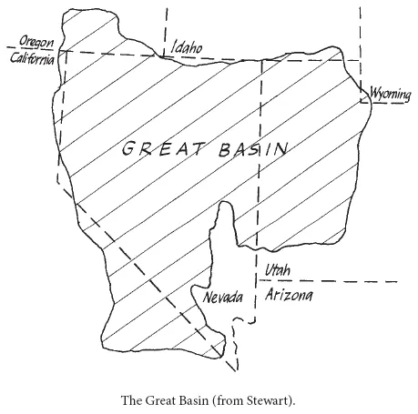
Only along the southern rim is the boundary ragged and indistinct. Here the deep incision of the Colorado River slices westerly from the high plateaus and gnaws deeply into the edge of the basin. The master drainage of the American Southwest has deeply penetrated to the north, connecting some of the valleys of southwestern Utah and southeastern Nevada with the ocean. The deeper the Colorado cut through the shales and sands of the plateaus, the steeper is the course of its tributaries. This high gradient gives power to the streams, and they have sliced deep canyons into the southern heartland of the Great Basin.
It was only later that I realized my youthful picture of the Great Basin was completely incorrect. The boundaries were accurate, but a featureless sand-filled bowl with lofty mountainous rims it is not. On the contrary, the floor of the bowl is broken into high snowcapped mountain ranges separated by broad elongated valleys. Although the drainages never reach the sea, it is by no means a lowland. The valley floors are generally between four and five thousand feet above sea level, and the intervening mountains tower up to thirteen thousand feet. The valley floors in the central part of the basin are higher than along its flanks. The Great Basin resembles an upside-down, broken, and cracked bowl. No surface water leaves the Great Basin except by evaporation. Biologists and anthropologists have confused the usage of the term Great Basin by utilizing other criteria to define Great Basin biota or cultures, but the definition of the geographic region is founded only on hydrology.
Geologists have also inadvertently added to the confusion involving the definition of the Great Basin. We recognize the geographic and hydrologic character of the region. However, we include it as the northern portion of a much larger geologic province with a name so similar as to often cause perplexity even among its residents: the Basin and Range. This geologic territory includes virtually all the Great Basin and extends south and east through Arizona, New Mexico, and Texas, all the way into Mexico. The Basin and Range can be differentiated from its neighboring geologic regions by its uplifted and tilted ranges separated by broad elongated basins. Southern New Mexico and Arizona have the same geologic style as Nevada.
The hydrologic Great Basin, then, is that portion of the geologic Basin and Range with no drainage to the sea. The two great rivers of the West, the Colorado and the Columbia, are gnawing away at the flanks. But the rainfall is too sparse, the rivers have too little energy, and the uplift of the inverted bowl is too recent for the big rivers to breach the defenses of the Great Basin—yet.
In fact, the boundaries of the geologic Basin and Range do not exactly coincide with the hydrologic Great Basin. There are slight variations along all the borders except the southern edge. Here the Great Basin and Basin and Range boundaries are sharply divergent. The Colorado River has managed to slice across the trend of the Basin and Range, and the northward-reaching tributaries deeply incise the southern boundary of the Great Basin.
The neighboring geologic provinces are sharply contrasted to the tilted and topsy-turvy Basin and Range geology. To the north, young lavas of the Snake River Plain buried the Basin and Range beneath thousands of feet of almost horizontal volcanic effusives. These black flows poured southward into northern Nevada.
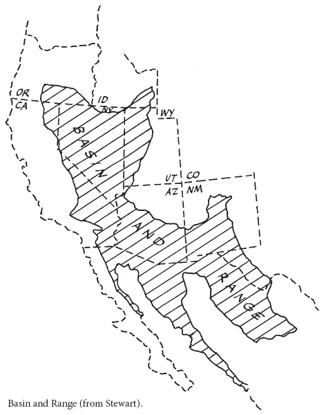
The Colorado Plateau bounds the Basin and Range to the east. This is a geologically stable region of brightly hued rocks that have recently been uplifted vertically almost one mile with virtually no deformation of the horizontal layers. Rivers have deeply incised the uplifted Colorado Plateau into some of the most scenic canyons in the United States. Many have been designated as national parks. This is the domain of the Grand Canyon, Bryce Canyon, and Zion. To the south, the Basin and Range merges into the mountainous structures of central Mexico. To the west of the Basin and Range lies the Sierra Nevada geologic province. This province is characterized by massive intrusions of once-molten rock that has cooled into the tough, erosion-resistant core of the Sierras.
3
RAW MATERIALS OF THE GREAT BASIN
I have not always been a geologist. In fact, I had every intention of being a biologist. I have always been fascinated, even as a child, by the variety and adaptations of life around me. Biology is the science of excitement. Life abounds with freshness and the prospects of discovery. I had a high school friend who was destined to be a geologist and is one today. How boring were his interests. He collected dusty stones that sat in dignified rows on musty shelves in his basement, each rock identified by a jaw-breaking,...
Table of contents
- Cover Page
- Title Page
- Copyright Page
- Dedication
- Contents
- Preface
- Part I - Rocks, Concepts, and Processes
- Part II - Great Basin History
- Part III - The Great Basin Today
- Acknowledgments
- References
- Index
Frequently asked questions
Yes, you can cancel anytime from the Subscription tab in your account settings on the Perlego website. Your subscription will stay active until the end of your current billing period. Learn how to cancel your subscription
No, books cannot be downloaded as external files, such as PDFs, for use outside of Perlego. However, you can download books within the Perlego app for offline reading on mobile or tablet. Learn how to download books offline
Perlego offers two plans: Essential and Complete
- Essential is ideal for learners and professionals who enjoy exploring a wide range of subjects. Access the Essential Library with 800,000+ trusted titles and best-sellers across business, personal growth, and the humanities. Includes unlimited reading time and Standard Read Aloud voice.
- Complete: Perfect for advanced learners and researchers needing full, unrestricted access. Unlock 1.5M+ books across hundreds of subjects, including academic and specialized titles. The Complete Plan also includes advanced features like Premium Read Aloud and Research Assistant.
We are an online textbook subscription service, where you can get access to an entire online library for less than the price of a single book per month. With over 1.5 million books across 990+ topics, we’ve got you covered! Learn about our mission
Look out for the read-aloud symbol on your next book to see if you can listen to it. The read-aloud tool reads text aloud for you, highlighting the text as it is being read. You can pause it, speed it up and slow it down. Learn more about Read Aloud
Yes! You can use the Perlego app on both iOS and Android devices to read anytime, anywhere — even offline. Perfect for commutes or when you’re on the go.
Please note we cannot support devices running on iOS 13 and Android 7 or earlier. Learn more about using the app
Please note we cannot support devices running on iOS 13 and Android 7 or earlier. Learn more about using the app
Yes, you can access Geology of the Great Basin by Bill Fiero in PDF and/or ePUB format, as well as other popular books in Biological Sciences & North American History. We have over 1.5 million books available in our catalogue for you to explore.