The Ancient Near East embraces a vast geographical area, from the borders of Iran and Afghanistan in the east to the Levant and Anatolia, and from the Black Sea in the north to Egypt in the south. It was a region of enormous cultural, political and linguistic diversity.
In this authoritative new study, Amélie Kuhrt examines its history from the earliest written documents to the conquest of Alexander the Great, c.3000-330 BC. This work dispels many of the misapprehensions which have surrounded the study of the region. It provides a lucid, up-to-date narrative which takes into account the latest archaeological and textual discoveries and deals with the complex problems of interpretation and methodology.
The Ancient Near East is an essential text for all students of history of this region and a valuable introduction for students and scholars working in related subjects.
Winner of the AHO's 1997 James Henry Breasted Award.
Trusted by 375,005 students
Access to over 1.5 million titles for a fair monthly price.
Part I THE DEVELOPMENT OF STATES AND CITIES (c. 3000-c. 1600)
1 Mesopotamia in the Third Millennium BC
1a the Background (c. 6000-c. 2900)
Environment
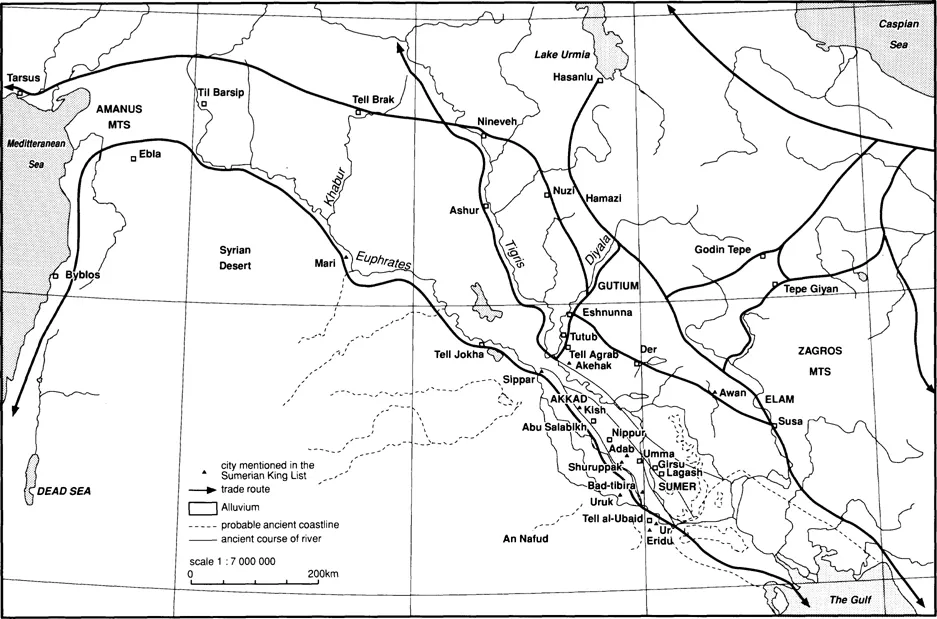
At the time that the first written documents begin to yield some coherent sense (c. 3200, see Green 1980), Mesopotamia had been inhabited for well over 2000 years. At that time (c. 5000) the shoreline at the head of the Arab-Persian Gulf extended further south, although a rise in sea-level had shifted it northwards by at least 4000, if not earlier. A number of books show the Gulf coast extending much further north in antiquity than it does today, reflecting a view held early this century. But it was argued in the early 1950s (Lees and Falcon 1952) that this was not the case. The Tigris and Euphrates rivers deposit most of their sediment before reaching the sea, which causes problems with irrigation and can result in ancient sites becoming totally buried under silt (as in the case of the important prehistoric site of Ras al-’Amiya in northern Babylonia), but would have left the coastline virtually unchanged for the last six thousand years or so. More recently, again, doubts have been voiced about the Lees and Falcon hypothesis (Adams 1981; Sanlaville 1989), and some scholars are once more accepting that the Gulf coast lay further north in antiquity than it does today. Whatever view is adopted, it seems that Ur and Eridu were probably always the most southerly of the Mesopotamian cities, for between them and the sea stretch the marshes of Iraq, which are not capable of supporting large communities.
The marshes have always been an important factor in Mesopotamian history by providing a refuge for rebels, as they are difficult to control. They also represent an important resource, providing tall reeds for roofing and reed products such as baskets and mats, as well as food items such as fish, waterfowl and wild boar. Some of the earliest iconographic motifs on items such as cylinder seals1 are elaborate reed huts, directly comparable to the splendid guesthouses constructed by the modern Marsh Arabs (W. Thesiger, The Marsh Arabs, London, 1964), and what appear to be reed bundles associated with the Sumerian goddess Inanna. Another important resource that grows well in the lower reaches of the two rivers is the date-palm, whose fronds can be used for roofing and its fibrous trunk for ropes and light constructions. But it is valued above all for its fruit, which ripens in the autumn to supplement the spring crops, can be easily stored and provides excellent nutrition. For successful cropping, the trees need careful cultivation and artificial pollination. Their important role in the south Mesopotamian economy is reflected in later Assyrian texts that refer to the cutting down of date-palms as a strategic measure by invading armies. At least as important as these local resources is the lack of other important raw materials, which all had to be imported. South Mesopotamia has no sources of metals, no trees that produce suitable timber for larger constructions and only insignificant amounts of stone. The focus of much documented Mesopotamian commercial and imperial activity is the acquisition of these items.
Map 2 Early Mesopotamia
The courses of the two rivers draining the flat south Mesopotamian plain are not always stable, and have changed from time to time. This fact, together with their spring flooding (at ripening and harvest-time) and the deposition of great quantities of silt, makes their use for irrigation into a particularly hard task (cf. BSAG 4 and 5). A further hazard is the rapid evaporation of surface water, causing salinisation of the soil which, it was argued in an influential paper in 1958 (Jacobsen, Science 128: 1251-1258; cf. Jacobsen 1982), could result in declining crop yields and was exacerbated by irrigation, thus triggering political crises. While it is certainly true that there is a problem with salt in the area, it has now been shown, fairly conclusively, that the authorities of the Mesopotamian cities always recognised the problem of soil salinity and had techniques of dealing with it (Powell 1985). The Euphrates and Tigris flow at very different rates (the Tigris is much faster flowing): the former is by far the easier to use for irrigation, and the settlement pattern reflects this. Cities and villages are generally located on canals leading east from the Euphrates, but there is very little urban settlement along the Tigris below Baghdad.
The development of settled life
The earliest ‘culture’ (reflecting a distinct artefactual assemblage) related to south Mesopotamia is the Samarran of the sixth millennium, identified on sites located mainly in east Iraq near the Iranian border and slightly north of Baghdad (see table 1). Rain-fed farming is not feasible here, and at two sites (Choga Mami, Tell es-Sawwan; see Oates and Oates 1976 [0P]; Helbaek 1972) evidence for artificial irrigation has been found. This is thought to have been organised on a community, or possibly family, basis, as the sites are quite small and did not expand significantly.
Table 1 Early Mesopotamia: chronology of main archaeological phases
North
South
6000
Hassuna
Samarra
5500
Halaf
Oueili
5000
‘Ubaid 1 (Eridu)
‘Ubaid 2 (Hajji Mohammed)
4500
‘Ubaid 3 (“Ubaid 1’)
‘Ubaid 4 (“Ubaid 2’)
4000
Tepe Gawra
Early Uruk
3500
Late Uruk/Uruk IV
3000
Uruk III/Jemdet Nasr
2900
Early Dynastic period (ED I)
2700
ED II
2600
ED III
An analogous development was also taking place around this time further south, shown by the French excavations of a flourishing agricultural village at Tell Oueili (near later Larsa; Huot 1991; 1992), which represents a forerunner of the well-attested farming culture of the south, the ‘Ubaid (c. 5000-4000). The ‘Ubaid culture is named after the site near Ur where it was first identified by Woolley in the 1920s. Its cultural sequences were clarified by Oates (1960), who defined four main phases. The distinctive elements of ‘Ubaid 3 have been found well beyond the confines of southern Iraq, in north Iraq, Syria, Iran, many (about forty) sites in Saudi Arabia, where it represents an intrusive element, and in the Arab-Persian Gulf. How should we interpret this evidence? Oates has suggested that it may reflect the attempt by people in south Mesopotamia to control and exploit trade routes in order to acquire the resources so signally absent there. Some support for this hypothesis may be found in the fact that a number of the northern ‘Ubaid sites are distributed along the route leading to the Ergani Maden copper mines in south Turkey. But how such control might have been exercised is unknown. One other significant find should be noted: at Eridu a sequence of sanctuaries underlies the large, later sacred precinct of 2100-2000, providing a continuity of temple-building in the same spot from ‘Ubaid 1 right through into the historical period. This is important evidence for cultural continuity despite the technological and political changes that occurred over 3000 years.
The cultural phase succeeding the ‘Ubaid, the Uruk (c. 4000-2900), is marked by a change in pottery: a fairly plain wheel-made ware replaced the painted ‘Ubaid ones. The culture takes its name from the site of Uruk/Warka, which has provided the main, indeed almost the sole, evidence for all its stages, although the earliest sequences are still rather poorly known. The different name does not imply that the Uruk phase (during the latest periods of which the great urban centres using writing develop) represents a fundamental change in culture, reflecting a new population. The changes that mark its appearance are rather determined by new technologies and materials, such as the use of the wheel, increased metal production, and the development of stone-working for vessels. This is an important point, since many have tried to associate the Uruk phase with the arrival of the Sumerians, whose language (which cannot be linked to any of the known language families) is the earliest fully readable one identified in the Uruk tablets (Jones 1969; Oates 1960). At present there is no persuasive evidence that the Sumerians moved into the area of south Iraq at any particular point or that they were ever the sole ethnic group in the region (Oates 1960). As far as the obviously limited material for tracing answers to this question goes at present, Sumerians probably lived in this region together with other peoples (at least one group must be related to the later speakers of Semitic Akkadian) from the earliest times.
The Late Uruk period
Towards the end of the Uruk phase (Uruk 4: c. 3500-3200) the first written records appear, using pictograms, usually, although not exclusively (Gelb 1969), representing accounts (Green and Nissen 1987). The cuneiform that can be read as Sumerian developed from these early pictograms during the succeeding Uruk 3 period (c. 3200-2900; also known as ‘Jemdet Nasr’).2 At the same time there appear immense ceremonial complexes at the sanctuary sites of Eanna and Anu in Uruk: they are set on large platforms, with elaborate approaches and layouts, and some are built of stone. The walls have intricate niches and the buildings contain enormous (2m diameter) columns, freestanding and attached (‘engaged’). The column drums, like the walls, are decorated with mosaic patterns made up of small cones. The points of the cones are fitted into the wall and the flat, visible ends are coloured yellow, black or red. This phenomenon is not exclusive to Uruk - a similarly elaborate, painted structure has been revealed at ‘Uqair to the north (near Kish), and remnants of another at Ur; and there are similar developments at Susa in western Elam. Associated with these structures is a range of objects with characteristic decoration, such as stone vases, inlaid or worked in relief, or a finely carved trough. The excavators also found some beautifully sculpted objects, such as a marble mask which originally had its eyes and brows inlaid with precious materials, and other decorations applied to the hair (Strom-menger and Hirmer 1965 [0M] pls. 30-31). It is possible that this was originally part of a statue or relief, in which case the complete figure would have been almost life-size. A significant find from this period is a basalt stele with the relief of two figures hunting lions: one wields a spear, the other shoots with a bow. As the two figures are identically dressed, bearded and coiffed, it is possible that the same person is being shown using different weapons. A similarly dressed person is depicted on a number of objects from Uruk: he appears repeatedly on the large, finely worked cylinder seals of this period, where he is the dominant figure in complicated scenes, and, most strikingly, he is almost certainly shown at the culminating point of the complex of activities depicted on the large Uruk vase (fig. 1).
What does this evidence add up to? The appearance of writing, the elaborate buildings, the use of imported materials, sophisticated art-works and the population increase reflected in the size of settlements, all signal the emergence of substantial urban communities with developed socio-economic structures. Nothing else can explain the materials, techniques and scale of buildings. But their precise origins, as well as specific character, remain a matter for speculation. The evidence points to a highly evolved political system in place: the figure dominating so many of the pictorial scenes probably stands at ...
Table of contents
Cover Page
Half Title page
Title Page
Copyright Page
Contents
Figures
Map
Tables
Abbreviations
Preface
Introduction
Part I The Development of States and Cities (c. 3000-c. 1600)
Part II The Great Powers (c. 1600-c. 1050)
Part III Political transformation and the great empires (c. 1200-330)
Bibliography
Index
Frequently asked questions
Yes, you can cancel anytime from the Subscription tab in your account settings on the Perlego website. Your subscription will stay active until the end of your current billing period. Learn how to cancel your subscription
No, books cannot be downloaded as external files, such as PDFs, for use outside of Perlego. However, you can download books within the Perlego app for offline reading on mobile or tablet. Learn how to download books offline
Perlego offers two plans: Essential and Complete
Essential is ideal for learners and professionals who enjoy exploring a wide range of subjects. Access the Essential Library with 800,000+ trusted titles and best-sellers across business, personal growth, and the humanities. Includes unlimited reading time and Standard Read Aloud voice.
Complete: Perfect for advanced learners and researchers needing full, unrestricted access. Unlock 1.5M+ books across hundreds of subjects, including academic and specialized titles. The Complete Plan also includes advanced features like Premium Read Aloud and Research Assistant.
Both plans are available with monthly, semester, or annual billing cycles.
We are an online textbook subscription service, where you can get access to an entire online library for less than the price of a single book per month. With over 1.5 million books across 990+ topics, we’ve got you covered! Learn about our mission
Look out for the read-aloud symbol on your next book to see if you can listen to it. The read-aloud tool reads text aloud for you, highlighting the text as it is being read. You can pause it, speed it up and slow it down. Learn more about Read Aloud
Yes! You can use the Perlego app on both iOS and Android devices to read anytime, anywhere — even offline. Perfect for commutes or when you’re on the go. Please note we cannot support devices running on iOS 13 and Android 7 or earlier. Learn more about using the app
Yes, you can access The Ancient Near East by Amélie Kuhrt in PDF and/or ePUB format, as well as other popular books in Art & History of Ancient Art. We have over 1.5 million books available in our catalogue for you to explore.