Climate change is likely to continue to have severe impacts, including sea level rise. At the same time, population increase and development imperatives create additional pressure on available water resources. These changes are problematic for the Mediterranean coastal areas and especially the Nile Delta coast. Particular focus of this study is on salinization of groundwater resources in the Nile Delta Aquifer (NDA) due to saltwater intrusion. To assess current conditions and develop future adaptation strategies for the NDA, a 3D model simulating regional variable-density groundwater flow and coupled salt transport was constructed based on available data set, using the SEAWAT code. A method for identification of the most representative model has been developed, based on testing different simulation periods during which the NDA has 'evolved' from completely fresh groundwater conditions to conditions representative for the year 2010.This model was then applied to analyze possible future NDA conditions under several predefined scenarios of sea level rise and groundwater extraction. This analysis indicated that the impacts from further extractions of groundwater on availability of fresh groundwater in the aquifer are more significant compared to those from sea level rise. Furthermore, three different adaptation measures and their impacts in the Sharkeya Nile Delta governorate were tested. It was shown that that changing crop types and irrigation practices towards water saving options seem to be more promising than artificial recharge with injection wells or extraction and usage of brackish groundwater after desalination. The developed model is useful for further Water-Food Nexus studies.
eBook - ePub
Climate Change and Development Impacts on Groundwater Resources in the Nile Delta Aquifer, Egypt
- 130 pages
- English
- ePUB (mobile friendly)
- Available on iOS & Android
eBook - ePub
Climate Change and Development Impacts on Groundwater Resources in the Nile Delta Aquifer, Egypt
About this book
Trusted by 375,005 students
Access to over 1.5 million titles for a fair monthly price.
Study more efficiently using our study tools.
Information
Subtopic
Environmental ScienceIndex
Biological Sciences1
INTRODUCTION
1.1 INTRODUCTION TO THE STUDY AREA
Egypt lies in the northeastern corner of Africa with a total area of about one million km2. It consists of a vast desert plateau crossed by the Nile Valley and the Nile Delta (ND) that represents about 5 percent of the Egyptian area. The majority of Egypt’s surface area is desert. Most of the agricultural land lies close to the banks of the River Nile and its Delta [1].
The ND is the food basket of Egypt. It is the most fertile land where about 60% of Egypt’s population lives. Like most of the deltas around the world, agriculture activities are dominant in the ND due to the nature of the soil and the presence of an irrigation system. Consequently, it has a great economical and residential importance to Egypt (Figure 1.1).
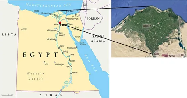
Figure 1.1. The location map of the Nile Delta
The Egyptian population has increased from 22 million in 1950 to around 100 million in 2019. It is even predicted that the population will increase to more than 120 million by 2050 [2]. This rapid increase of population decreases the water resources allocated per capita. Currently, the water allocation per capita in Egypt is 720 m3/year [2]. If the population growth continues with this trend, the water allocated per capita will severely decline to critical levels. Over the coming years, this declining trend will cause serious risks.
Nile water alone is no longer sufficient for the increasing water requirements of different development activities in Egypt and the highly increasing population. Therefore, groundwater is increasingly being exploited. Extensive extraction of fresh water from the Nile Delta Aquifer (NDA) intensifies saltwater intrusion (SWI) [3]. An emerging problem has a huge impact on the salinization of wells leading to several undesirable consequences. Moreover, this valuable resource is being threatened by SWI due to sea level rise (SLR), a common problem for all coastal aquifers around the world [4].
SLR is one of the expected global warming impacts due to climate change (CC) [5]. The Egyptian coastal area of the ND is one of the highly sea level rise (SLR)-vulnerable regions in the world due to its low elevation [5]. The SLR accelerates the SWI into the NDA and hence affecting the quality of the groundwater. It is predicted that SLR will directly affect more than 3.8 million capita and an area of about 1800 km2 will be submerged in the ND [6]. This calls for a rapid adaptation and management plan.
The issue of the management of groundwater in the ND has become one of the top priorities in the Egyptian water agenda, to meet not only the economic needs but also the social, cultural and environmental needs. While there is almost a consensus that CC has currently already induced changes in groundwater salinization, it is projected that they will amplify in the future [5]. There is a gap of knowledge about the deterioration in groundwater salinization, a situation which is resulting from lack of suitable hydrological monitoring and modeling systems. In particular, current projections and adaptation measures for future salinization scenarios are very limited. This stresses the need to understand and analyze the hydrological conditions and their impact on groundwater behavior in the NDA, in addition to studying the negative impacts of SLR and development on the surrounded environment, from a new perspective focusing on groundwater quality. This could be achieved by simulating the current condition and predicting the future scenarios with reliable updated hydrological data series.
A concrete adaptation measure could be then built on the output of those realistic simulations. The approach taken in this study can be applicable for other coastal aquifers. Whereas Nile Delta is no exception. In spite of differences in geometry and their hydrological data, most deltaic areas face similar development and climate stresses.
1.2 OBJECTIVES AND RESEARCH QUESTIONS
The overall goal of this research is to contribute towards ensuring quality and sustainability of groundwater in the NDA as a strategic and economic source for life and development. Sustainable groundwater resources development and environmentally sound protection should be an end goal. Their attainment is closely linked to water resources planning and management and influenced by economic and social constraints.
Note that a review of the state of the knowledge and related knowledge gaps are presented in details in chapter 2.
1.2.1 Main objective
The broad objective of this research is to contribute to the development of a framework for the long term planning for exploitation and sustainable management of groundwater resources in the NDA. One main contribution to the framework is the developed variable-density 3D groundwater model that will be used to address the future groundwater resources development within several scenarios of CC impact (SLR) and the impact of development (groundwater extraction).
1.2.2 Research questions
- What is the current knowledge regarding groundwater salinization in the study area, and where are the knowledge gaps?
- What is the current situation of salinization in the Nile Delta and its governorates? What are the recommended locations for extraction from the current perspective (2010)?
- What is the impact of saltwater intrusion under the various proposed future scenarios of climate change (sea level rise) and development (groundwater extraction) in the whole Nile Delta Aquifer?
- What are the best locations and the vulnerable ones for groundwater extraction in the Nile Delta governorates in a long-term perspective?
- What are the proposed adaptation measures that minimize the loss of fresh groundwater due to saltwater intrusion, and what are their limitations?
1.3 METHODOLOGY
This research addresses the impact of SLR and excessive groundwater extraction and their consequences on the NDA through a number of steps. The following methodological steps have been followed.
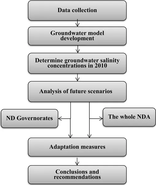
Figure 1.2. Flow chart of the methodological steps
This chapter provides a general overview over the followed methodology; further details of methods applied in each study are given in the respective chapters.
1.3.1 Data collection
For better management of groundwater resources, it is crucial to have enough reliable data about the physical, hydrological and hydro-(geo)logical settings of the study area. Physical settings include land use, meteorological data, topography and soil classification. The data was collected from different private and governmental entities. This phase included the following stream of activities:
- Identifying the general characteristics of the study area.
- Collecting previous studies, historical data, and field investigations.
- Reviewing climate trends and scenarios for SLR at the country level based upon examination of results from recent global climatic models, as well as results published in scientific literature.
- Reviewing current salinity control projects that are funded by the government or international donors, as well as development priorities of Egypt, in order to determine the degree of attention to potential risks posed by CC on groundwater sector.
- Analysis of the collected data and checks for ensuring data quality.
1.3.2 Groundwater model development
Conceptually speaking, the ND region consists of two main aquifer systems, the Holocene and the Pleistocene aquifers. The Holocene aquifer is composed of medium to fine-grained sand, silt, clay and peat (Newnile sediments) while the Pleistocene aquifer is composed of thick layers of quarzitic sand and pebbles [7]. Surface irrigation network and main branches of the Nile were included to model the exchange between surface water and groundwater.
In order to develop the conceptual model, the required data was collected, organized and digitized as follows:
- Contour maps showing the elevation and thickness of different aquifer layers.
- Geological and cross sections maps of the NDA.
- Contour maps of porosity, hydraulic conductivity, groundwater heads, salinity concentrations in different depths, canals and drains network data.
- Groundwater extraction and observation wells’ data.
The system was simulated by using the MODFLOW and SEAWAT codes to determine the spatial distribution of salinity concentrations in the NDA. The proposed model combination fits best for the research because it describes the physical processes of SWI well, it provides wide range of possibilities to simulate groundwater management and SLR related scenarios, the model codes have been widely used in the world and most of the required data are available within the time and resource limits of this study.
In the research, the initial salinity concentration distribution of the model of the NDA is completely fresh with only saline concentration at the Mediterranean seaside. Our target is solely to determine the appropriate simulation period, which provides the best match between the modeled and observed salinity concentration data as, will be discussed in details in chapter 3. The final goal is to have a regional 3D groundwater salinity model that confidently represents the present situation (2010) which can be used for future predictions. We designated the year 2010 as the reference year, as most data are available for this year.
1.3.3 Analysis of future scenarios
The final developed model results are used as initial conditions in order to simulate future conditions under several proposed scenarios. These scenarios are prepared to cover different aspects of SLR and groundwater extraction for the period until 2100. Extreme conditions are examined together, e.g. high extraction levels and high SLR to determine the impacts, especially in terms of distribution of different types of groundwater with regards to salinity concentration and focusing on freshwater availability. Also, low extraction levels with high SLR are examined in order to make a comparative analysis of SLR impact on groundwater salinization versus human interventions. An assessment for the whole NDA and for individ...
Table of contents
- Cover
- Half Title
- Title Page
- Copyright Page
- Dedication Page
- Summary
- Samenvatting
- Acknowledgments
- Contents
- 1 Introduction
- 2 A review of seawater intrusion in the Nile Delta groundwater system
- 3 Assessing the fresh-saline groundwater distribution in the Nile Delta aquifer using a 3d variable-density groundwater flow model
- 4 Impacts of SLR and groundwater extraction scenarios on fresh groundwater resources in the Nile Delta governorates, Egypt
- 5 Adaptation measures to impacts from groundwater salinization threats in the Nile Delta Aquifer
- 6 Conclusions and recommendations
- List of Acronyms
- List of Tables
- List of Figures
- About the Author
Frequently asked questions
Yes, you can cancel anytime from the Subscription tab in your account settings on the Perlego website. Your subscription will stay active until the end of your current billing period. Learn how to cancel your subscription
No, books cannot be downloaded as external files, such as PDFs, for use outside of Perlego. However, you can download books within the Perlego app for offline reading on mobile or tablet. Learn how to download books offline
We are an online textbook subscription service, where you can get access to an entire online library for less than the price of a single book per month. With over 1.5 million books across 990+ topics, we’ve got you covered! Learn about our mission
Look out for the read-aloud symbol on your next book to see if you can listen to it. The read-aloud tool reads text aloud for you, highlighting the text as it is being read. You can pause it, speed it up and slow it down. Learn more about Read Aloud
Yes! You can use the Perlego app on both iOS and Android devices to read anytime, anywhere — even offline. Perfect for commutes or when you’re on the go.
Please note we cannot support devices running on iOS 13 and Android 7 or earlier. Learn more about using the app
Please note we cannot support devices running on iOS 13 and Android 7 or earlier. Learn more about using the app
Yes, you can access Climate Change and Development Impacts on Groundwater Resources in the Nile Delta Aquifer, Egypt by Marmar Badr Mohamed Ahmed in PDF and/or ePUB format, as well as other popular books in Biological Sciences & Environmental Science. We have over 1.5 million books available in our catalogue for you to explore.