Digital Mapping and Indigenous America
eBook - ePub

Digital Mapping and Indigenous America

Janet Berry Hess, Janet Berry Hess

Share book
  1. 232 pages
  2. English
  3. ePUB (mobile friendly)
  4. Available on iOS & Android
eBook - ePub

Digital Mapping and Indigenous America

Janet Berry Hess, Janet Berry Hess

Book details
Book preview
Table of contents
Citations

About This Book

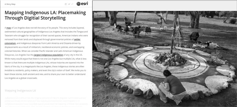
Employing anthropology, field research, and humanities methodologies as well as digital cartography, and foregrounding the voices of Indigenous scholars, this text examines digital projects currently underway, and includes alternative modes of "mapping" Native American, Alaskan Native, Indigenous Hawaiian and First Nations land. The work of both established and emerging scholars addressing a range of geographic regions and cultural issues is also represented. Issues addressed include the history of maps made by Native Americans; healing and reconciliation projects related to boarding schools; language and land reclamation; Western cartographic maps created in collaboration with Indigenous nations; and digital resources that combine maps with narrative, art, and film, along with chapters on archaeology, place naming, and the digital presence of elders.

This text is of interest to scholars working in history, cultural studies, anthropology, Native American studies, and digital cartography.

Frequently asked questions

How do I cancel my subscription?
Simply head over to the account section in settings and click on “Cancel Subscription” - it’s as simple as that. After you cancel, your membership will stay active for the remainder of the time you’ve paid for. Learn more here.
Can/how do I download books?
At the moment all of our mobile-responsive ePub books are available to download via the app. Most of our PDFs are also available to download and we're working on making the final remaining ones downloadable now. Learn more here.
What is the difference between the pricing plans?
Both plans give you full access to the library and all of Perlego’s features. The only differences are the price and subscription period: With the annual plan you’ll save around 30% compared to 12 months on the monthly plan.
What is Perlego?
We are an online textbook subscription service, where you can get access to an entire online library for less than the price of a single book per month. With over 1 million books across 1000+ topics, we’ve got you covered! Learn more here.
Do you support text-to-speech?
Look out for the read-aloud symbol on your next book to see if you can listen to it. The read-aloud tool reads text aloud for you, highlighting the text as it is being read. You can pause it, speed it up and slow it down. Learn more here.
Is Digital Mapping and Indigenous America an online PDF/ePUB?
Yes, you can access Digital Mapping and Indigenous America by Janet Berry Hess, Janet Berry Hess in PDF and/or ePUB format, as well as other popular books in Art & Art General. We have over one million books available in our catalogue for you to explore.

Information

Publisher
Routledge
Year
2021
ISBN
9781000367218
Edition
1
Topic
Art
Subtopic
Art General

1Alive with Story

Mapping Indigenous Los Angeles and Carrying Our Ancestors Home
Sarah Montoya

Introduction

As part of a continuum of resistance, digital projects and repositories offer platforms to reckon with settler representations of space and peoples. Two projects, Mapping Indigenous Los Angeles (MILA) and Carrying Our Ancestors Home (COAH), redress the relationship between Native and Indigenous bodies, communities, and land as they provide pedagogical tools for tribal communities, institutions, and settlers to dismantle settler colonial narratives. Mapping Indigenous LA, accessible at mila.ss.ucla.edu, unsettles colonial cartographic and geographic knowledge as it weaves together the stories of the Native and Indigenous inhabitants who originally occupied and have come to occupy Los Angeles as the result of complex relocations and diasporic processes. Indigenous digital counter-mapping projects confront and re-orient the colonial gaze through a nuanced rendering of relationships with space, place, and memory. Carrying Our Ancestors Home, accessible at coah-repat.com, addresses the history and intricacies of repatriation and offers insight into how tribal communities and institutions address the Native American Graves Protection and Repatriation Act (NAGPRA). Digital repositories and archives facilitate the preservation of cultural heritage and lifeways while simultaneously evidencing the legacy of political mobilization and current activism by Native communities. Though largely based on Gabrielino/Tongva lands (Los Angeles), these projects seek to build solidarity amongst and serve as repositories for global Native, Indigenous, and Aboriginal communities.

Land is Life: Mapping Indigenous LA

The colonial construction of Native and Indigenous peoples is deeply entangled with techno-scientific development and the establishment of settler colonial property regimes. Within the bounds of a colonial fantasy and settler colonial imaginary, land is configured as an exploitable resource and Native and Indigenous peoples are flattened into “flora and fauna” as objects to be managed by the settler state.1 The rhetoric of scientific objectivity and cartographic practices emphasizing “accuracy” and utility were weaponized by imperial and colonial powers to guise settler violence as space was transformed from territory into property.2 The creation of a settler state legal mechanism for dispossession solidified the notion of “lawfully” owned property as a cornerstone of settler societies. Aboriginal scholar Aileen Moreton-Robinson (Koenpal, Quandamooka Nation) offers the term “possessive logics” to understand the link between property to a white, patriarchal settler identity which, in turn, is intimately connected with the political project of establishing and maintaining settler conceptions of ownership.3 Denied personhood, humanity, and history through strategic colonial cartographic erasures, Native and Indigenous communities were and are un-placed and displaced.
Mapping Indigenous LA disrupts colonial erasure and displacement via digital counter-mapping in the form of story mapping. Mapping Indigenous Los Angeles utilizes Esri’s Story Maps via ArcGIS to re-map complex relationships amongst Native and Indigenous communities and serve as a repository for community histories. It features Spanish and English content and offers a series of pedagogical resources for educators and community members alike. The project is envisioned as a collaborative research project, guided by co-principle investigators who represent a variety of departmental affiliations at UCLA including Dr. Maylei Blackwell, Professor in the CĂ©sar E. ChĂĄvez Department of Chicana/o and Central American Studies, Dr. Mishuana Goeman (Tonawanda Band of Seneca), Professor in Gender Studies, and Dr. Wendy G. Teeter, Curator of Archaeology for the Fowler Museum and UCLA NAGPRA Coordinator. UCLA, as a land grant institution in one of the largest cities in the settler state of the U.S., functions an interdisciplinary hub for scholars working with and in Native and Indigenous communities. The project is supported by the Institute of American Cultures, California Humanities, University of California Humanities Research Institute, University of California Center for New Racial Studies, The UCLA Center for Digital Humanities, UCLA American Indian Studies Research Center, Social Science Computing, and the UCLA College of Social Sciences. Mapping Indigenous Los Angeles represents alliances and solidarities within the university and amongst Native and Indigenous communities within LA. The scope of the project includes Gabrielino/Tongva and Fernandeño Tataviam Band of Mission Indians, Pacific Islanders, peoples of Oceania, American Indian narratives of relocation to LA, peoples of the Latin American Indigenous Diaspora, and maps tracing Indigenous relationships with land and waterways. As part of its community collaboration, the site actively seeks to build relationships with Native and Indigenous peoples in LA and offers detailed guides on how to create community-authored maps to be featured on the site.

Source Materials

Story maps of MILA are the result of community-driven and community-generated content from Native and Indigenous peoples with relationships to LA. The project actively petitions communities for story maps and provides a lengthy, step-by-step screenshot tutorial and guide for communities to outline the entire process—from securing permissions and curating visual content to narrative development. In order to have a community story map featured on MILA’s site, communities are asked to reach out the MILA team with a story map concept and key points, their team/community, and a research timeline. After the initial contact and acceptance, MILA offers technical aid to those involved with the creation and maintenance of a story map. Esri’s Story Maps platform offers a readily available software, accessed via browser, that does not require high-level technical coding skill and can host narrative and visual content, in addition to map coordinates. Participants are encouraged to gather community histories in the form of photographs, interviews/oral histories, and videos to create dynamic and interactive experiences for viewers.
image
Figure 1.1From “Mapping Indigenous LA: Placemaking Through Digital Storytelling.”
Esri’s Story Maps features two-paneled content to provide historical and contemporary visual representations of Native and Indigenous placemaking. The community-authored narrative panel provides opportunities to link to definitions, concepts, and related content.
The story maps currently featured on the site represent the significant effort of Native and Indigenous peoples to create community-authored representations and disorient settler configurations of space. Many of the maps overtly address settler colonial violence and erasures and draw out complex historical racialization processes. “Mapping Indigenous LA: Placemaking Through Digital Storytelling” provides an in-depth overview of the project, highlighting local original inhabitants and the promise for cross-cultural exchanges in the densely networked cityscape of Los Angeles. “Latin American Indigenous Diaspora” documents crucial events, community organizations, and places of community gathering for both a variety of Mayan and Indigenous Oaxacan peoples. “Indigenous Urbanity in Los Angeles: 1910s–1930s” deftly brings together migration and labor histories, cinema and media studies, Native and Indigenous scholarship and activism, and offers an oral history of a Chumash/Tohono O’odham Elder, whose family has lived in the Wilmington/Carson for generations. Maps like the “Fernandeño Tataviam Map” and “Perspectives on A Selection of Gabrieleño/Tongva Places” offer intricate histories of dispossession and survival guided by Elders and community members, preserving Indigenous place-naming and the reclamation of historical place and presence. “American Indian Education Timeline & Resources” provides an overview of Indian education from its assimilationist, settler colonial roots to the establishment of tribal colleges and the current state of American Indian education. This map, like “American Indian Health Resources,” offers a series of currently accessible resources for American Indian community members. “Los Angeles Waterways” outlines the varied presence of waterways, both artificial and naturally occurring, along the LA landscape; the map regards water not simply as a resource but as an Indigenous lifeway and indicates current revitalization projects.

Resources and Pedagogical Materials

Mapping Indigenous Los Angeles hosts pedagogical materials and additional reading materials approved by Native and Indigenous community members and faculty. Again, the project encourages communities to offer their own community-created or community-approved resources. Teaching materials are divided by topic area and sub-divided into age ranges from K–12 resources to college-level reading materials. Topics encompass a variety of museum field trip guides, Indigenous and Native approaches to teaching, and resources for teaching Native American history ethically and responsibly in the state of California including critical approaches to the California Mission System. The site also provides resources for assessing American Indian materials and resources for Native and Indigenous educators. As such, MILA offers several avenues to dismantle settler state-sponsored narratives of conquest.

Challenges

As with many digital projects, data sovereignty4 and information privacy pose concerns. For Native and Indigenous peoples who have historically had data pilfered and turned over to the state,5 the right and ability to govern and keep secure knowledge and information is something each community must consider when deciding what information to share in a publicly available map through a university-affiliated project. The project currently requires that participants arrange information and data hosting through a variety of sites (for instance, Esri’s ArcGIS and image-hosting or video-hosting sites) and thus it is critical for participating Indigenous communities to carefully orchestrate community access and establish security protocol. MILA’s team offers workshops and technical support for Indigenous communities navigating the project.

Remapping Return: Carrying Our Ancestors Home

Until the passage of the Native American Grave Protection and Repatriation Act (NAGPRA) in the 1990s, the legal language surrounding Native human remains recapitulated settler violence. Archaeology and anthropology in the U.S. has a fraught relationship with scientific racism and routine grave desecration. Perhaps most infamous are Thomas Jefferson’s excavation of Indigenous burial mounds by enslaved peoples and Dr. Samuel Morton’s crania studies which required the regular decapitation of disinterred bodies.6 Morton’s phrenology study data codified scientific racism as it weaponized the trope of the “Vanishing Indian.”7 Scientific racism worked in tandem with the establishment of property regimes, and property regimes extended, too, to the remains of Native and Indigenous peoples. The relegation of Native peoples into landscape and association with primitivism enabled the display of sacred items and the remains of ancestors within the venue of Natural History Museums and established settler “ownership” over ancestral remains “discovered” on private property. Consider, for instance, the 1906 Federal Antiquities Act which utilized a legal language whereby archaeological resources become federal property. While it did attempt to limit looting, it communicated a worldview in which Native remains were the property of the United States government.8
Carrying Our Ancestors Home addresses both the violence of desecration and the victories and complexities of repatriation as it pertains to NAGPRA. This legislation was the hard-earned result of decades of organizing by Native and Indigenous peoples to reclaim sacred objects and human remains which had been violently and unethically taken, housed, and displayed. The law requires federal agencies and institutions having received federal funds to repatriate, or return, human remains, funerary objects, sacred objects, and objects of cultural patrimony.9 Much of the available materials on NAGPRA are authored by state-sanctioned entities or academic institutions, but COAH offers Indigenous and Native authored perspectives on repatriation for the benefit of both tribal community members and institutional representatives. The project again sees a UCLA-based team serving Native, Indigenous, and Aboriginal communities, directed by Dr. Wendy G. Teeter and Dr. Mishuana Goeman and managed by Sedonna Goeman-Shulsky (Tonawanda Band of Seneca), the Archaeology Collections Manager at the Fowler Museum. The project provides primary sources authored and approved by Indigenous and Native community members working with intuitions to trace the difficulties and varied protocols of repatriation. The site is built on Mukurtu CMS, an open-source content management system designed to house community digital heritage projects, and hosts a series of videos and relevant, curated literature as the project places institutions and tribal communities into conversation with one another.

Source Materials

In order to successfully repatriate ancestral remains and cultural items, institutions must develop respectful relationships with tribal communities and understand the context from which tribal and intuitional relationships emerged. To support this, COAH provides a socio-historical context for understanding NAGPRA and repatriation. The site hosts “Fighting for Our Ancestors,” a documentary tracing the American Indian Student Movement for Repatriation at UCLA in 1990s. The piece details on-campus and community American Indian political mobilization and the antagonistic response tow...

Table of contents