In this second edition of their classic text, Klyza and Trombulak use the lens of interconnectedness to examine the geological, ecological, and cultural forces that came together to produce contemporary Vermont. They assess the changing landscape and its inhabitants from its pre-human evolution up to the present, with special focus on forests, open terrestrial habitats, and the aquatic environment. This edition features a new chapter covering from 1995 to 2013 and a thoroughly revised chapter on the futures of Vermont, which include discussions of Tropical Storm Irene, climate change, eco-regional planning, and the resurgence of interest in local food and energy production. Integrating key themes of ecological change into a historical narrative, this book imparts specific information about Vermont, speculates on its future, and fosters an appreciation of the complex synergy of forces that shaped this region. This volume will interest scholars, students, and Vermonters intrigued by the state's long-term natural and human history.
eBook - ePub
The Story of Vermont
A Natural and Cultural History, Second Edition
- English
- ePUB (mobile friendly)
- Available on iOS & Android
eBook - ePub
The Story of Vermont
A Natural and Cultural History, Second Edition
About this book
Trusted by 375,005 students
Access to over 1.5 million titles for a fair monthly price.
Study more efficiently using our study tools.
Information

The Past as Prelude
The Early Evolution of Vermont’s Landscape
The history of the place now called Vermont can be traced back thousands of millions of years. The story of how this landscape was created is not simple. It involves the repeated collision of continents, the birth and death of oceans, and the occasional burial of the land under thousands of feet of ice. Although most of the events that shaped the landscape took place in the far distant past, long before humans even evolved, their consequences are felt strongly in the region even today. Vermont’s geological history not only defines its physical landscape but also delimits its ecological and cultural possibilities. Marble quarries in the Taconic Mountains, copper mines in the Connecticut River Valley, granite quarries in the northern Piedmont, ski slopes in the Green Mountains, fertile agricultural land in the Champlain Valley, deep-water fishing for landlocked ocean species in Lake Champlain, a near-complete cover of deciduous hardwood and spruce-fir forests, and scattered sand and gravel deposits that make on-site septic disposal possible: all of these owe their existence to the region’s long and complex geological history. This history is essential to understanding the basis for the ecological and cultural events that make up much of the story of Vermont.
The Surface of the Earth
Before the story of the early evolution of Vermont’s landscape can be told, a few basic concepts about the Earth’s physical structure must be understood. The entire surface of the Earth is dynamic. It is always in motion, being constantly reshaped and rearranged. This motion is a consequence of Earth’s internal structure. Its outermost layer, the lithosphere, forms a rigid shell about sixty miles thick over the entire planet (see Figure 1.1). The lithosphere sits upon the asthenosphere, a ductile layer of rock more than one hundred miles thick. In places, the asthenosphere remains partially molten from the intense heat in the Earth’s interior. Gravity and rising currents in the asthenosphere exert forces on the lithosphere above it, breaking it into pieces, or plates, and moving them around.
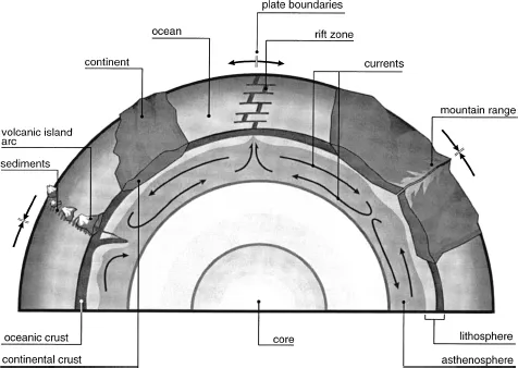
FIGURE 1.1 A stylized cross-section of the Earth, showing the major features associated with the movement of plates.
Each lithospheric plate has an outer crust. In some places, the crust is only about four miles thick and is rich in the heavy elements iron, magnesium, and calcium. In other places the crust is twenty to forty-five miles thick and has a much smaller percentage of heavy elements. This variation in the thickness and density of the crust results in a planetary surface that is extremely irregular. The thick, low-density crust rises high to form continents, and the thin, high-density crust forms the ocean floors. Currently, the lithosphere is broken into at least thirteen separate plates, six of which include major masses of continental crust. But this has not always been so. The configuration of the plates has changed repeatedly, as plates have broken apart and fused together all throughout Earth’s history.
Because the geological forces that shaped the present-day landscape of Vermont operated over a very long period of time, much of the story about how this landscape evolved—a story that can only be pieced together from the rocks and landforms evident today—is not entirely certain. The record of these forces was not preserved everywhere, and the timing of most events can only be estimated to within a few tens of millions of years. Although the story that follows is widely accepted as the most likely scenario of geological events in Vermont, the results of future research will almost certainly require changes in many details.
The Earliest Landscape
The stable nucleus of today’s North America is a platform of rock that underlies the northern and central portions of the continent. Much of its early history is unknown, but sediments that eroded from ancient mountains on this nucleus contain minerals that are at least 2,700 million years old, almost half as old as the Earth itself, at 4,600 million years. For clarity, we refer to earlier versions of the continent collectively as proto–North America. The eastern edge of proto–North America up until about 1,300 million years ago ran roughly from what is now eastern Mexico, across northern Louisiana and Alabama, up through the western Carolinas, northern New Jersey, the Connecticut River Valley, and the Gaspé Peninsula of Quebec. Hence, the region of present-day Vermont was, at that time, a coastal plain.
West of this ancient shore was a broad plain, formed from the erosion of ancient mountains in the continental interior. These sediments fused to become rock—a process called lithification—and later deformed and recrystalized to form much of the rock underlying eastern North America today. In the southern United States, the rocks formed from this ancient plain are now almost completely buried under younger rocks and sediment, but they are largely exposed in Labrador, southern Quebec, and the Adirondack Mountains.
Around 1,200 million years ago, proto–North America began to move toward another continent that lay to the east (see Figure 1.2a). As it went, the leading oceanic edge of the adjacent plate subducted under the leading edge of proto–North America and partially melted. This magma then rose to the surface through overlying cracks, forming a chain of volcanoes along proto–North America’s eastern margin. In less than 100 million years, proto–North America collided with the approaching eastern continent, pushing the chain of volcanoes, ocean sediments, and surrounding rock upward into a Himalaya-like mountain range of folded, broken, and highly metamorphosed rocks (see Figure 1.2b).
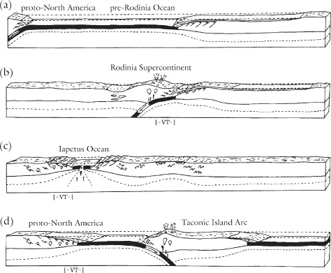
(a)1,200 million years ago: proto–North America of Rodinian age moves eastward.
(b)1,100 million years ago: Grenville Orogeny and the formation of the Rodinia supercontinent.
(c)575 million years ago: proto–North America moves westward to form the Iapetus Ocean.
(d)500 millions years ago: proto–North America moves eastward to create the Taconic Island Arc.
FIGURE 1.2 Evolution of Vermont’s landscape. Reproduced with permission from the New York Geological Survey/New York State Museum.
This collision is an example of one process whereby mountains are formed. This process is called orogeny and involves thrusting, folding, and fracturing in the outer and higher layers of the crust. The collision more than 1,100 million years ago, called the Grenville Orogeny, also resulted in the proto–North American plate fusing with the plate to the east to form a supercontinent called Rodinia. Indeed, Rodinia was perhaps the fusion of all the continental crust on Earth into a single global continent.
The Grenville Orogeny continued for about 80 million years, but eventually the rate of erosion exceeded the rate of uplift, and the mountain range began to wear away. For 300 million years, until 740 million years ago, the range continued to erode to a flat, sea-level plain. This mountain range itself is now completely gone, but evidence of the collision that formed it is found in the rocks embedded in the cores of the modern Adirondack and Appalachian mountains, including the Green Mountains, although these ranges themselves formed at later times. Almost all of the surface of the western flank of the Green Mountains from Ripton in central Vermont to just north of Massachusetts is made of rocks that were created during the Grenville Orogeny.
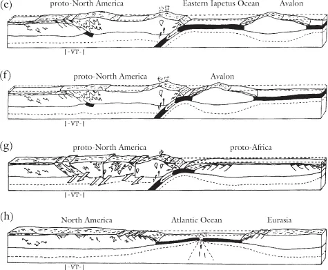
(e)450 million years ago: Taconic Orogeny; Proto–North America collides with the Taconic Island Arc to form the Taconic and Green mountains.
(f)400 million years ago: Acadian Orogeny; Proto–North America collides with Avalon to add to the Green Mountains and create New England east of the Connecticut River.
(g)320 million years ago: Alleghanian Orogeny; Proto–North America collides with proto-Europe and proto-Africa to form the southern Appalachian Mountains and the Pangaea supercontinent.
(h)180 million years ago: Pangaea breaks up and the Atlantic Ocean begins to form.
Supercontinents are, by their very nature, unstable. An uneven distribution of radioactive elements in the asthenosphere caused hot spots to form and rise beneath the plates, forcing them to rift apart. Initial rifting and volcanic activity began, among other places, along the suture where proto–North America had originally fused on its eastern boundary. By 575 million years ago, proto–North America was once again moving westward (relative to North America’s present orientation on Earth’s surface), leaving a new basin called the Iapetus Ocean opening in its wake (see Figure 1.2c).
During this rifting, much fracturing, or faulting, occurred as large blocks of crust pulled away from each other, allowing magma to fill the cracks and occasionally break the surface. The new eastern edge of proto–North America was once again the site of extensive breaking, volcanic activity, erosion, and sedimentation along the mountain walls and into the ocean.
The Iapetus Ocean continued to widen for at least 100 million years, reaching a width comparable to that of the present-day Atlantic Ocean. During this time, sediments washing off the eastern flank of proto–North America accumulated in adjacent coastal waters. These sediments lithified into the diverse sequence of limestones and shales that are seen today in the lowlands and islands of the Champlain Valley and in the Valley of Vermont, the narrow valley that lies between the Green Mountains and Taconic Mountains. Lithified early in the evolutionary history of multicellular life, these rocks reveal a rich diversity of ancient life forms, including algae, sponges, corals, bivalves, nautiluses, and trilobites. Furthermore, at this time proto–North America was situated in tropical water of the Southern Hemisphere, having not yet begun its eventual movement into temperate northern latitudes, so the life forms preserved in these rocks represent very different types of organisms from those present in the region today.
The Taconic Orogeny
Then, about 500 million years ago, the relative direction of the proto–North American plate reversed once again (see Figure 1.2d). As the plate moved eastward, its oceanic part was subducted under its counterpart on the adjacent plate. The resulting melting and volcanic activity created at least one and perhaps two chains of islands at the leading edges of overriding plates. One of these chains, called the Taconic Island Arc, probably extended a very long distance through the Iapetus Ocean, from what is today Alabama to Newfoundland, effectively dividing the Iapetus into eastern and western parts.
Subduction and island arc growth continued where proto–North America and the more easterly plate met, until by 450 million years ago the Taconic Island Arc was an immense land mass many miles wide, with high volcanoes on its western edge and broad plains of sediment to the east, spreading out into the basin of the eastern Iapetus Ocean. At about this time, the Taconic Island Arc collided and fused with proto–North America (see Figure 1.2e). This collision, the Taconic Orogeny, formed another tall chain of mountains stretching along the entire eastern margin of the continent.
The mountain ranges that formed during the Taconic Orogeny have largely eroded, the sediments mostly carried westward into the shallow sea that at that time filled most of the interior of proto–North America. Remnants of these mountains can still be seen, the two most notable in Vermont being the Taconic Mountains, which run between Vermont, Massachusetts, and Connecticut on the east and New York on the west, and the Green Mountains, which run as a backbone north and south through the center of the state. Material from the arc itself also forms much of the lowlands on the eastern side of the Connecticut River.
The collision of the Taconic Island Arc with proto–North America caused the crust to break into faulted blocks that overrode each other all along the line of contact. Much of the surrounding rock deformed and recrystallized because of the high temperatures and pressures resulting from the collision and burial beneath the stacked fault blocks. This collision is probably the origin of many of the minerals mined in Vermont historically, including iron, gypsum, copper, talc, soapstone, and asbestos. The distribution of the precursor minerals in sediments, metamorphic processes, and the infusion of mineral-rich liquids into cracks in the rock led to deposits of particular minerals in locations that today are close to the surface (and are discussed in more detail in Chapters 4 and 5). The amount of compression caused by the collision was enormous, and faulting resulted in extensive overlap and jumbling of blocks.
The Acadian Orogeny
The force of the collision between the Taconic Island Arc and proto–North America was so great that the oceanic crust attached on the eastern edge of the Taconic Island Arc, which was now fused with proto–North America, broke. As proto–North America continued to move eastward, the oceanic crust of the adjacent plate began to subduct under the proto–North American plate. Volcanic activity was thus renewed, but this time it occurred right along the new eastern edge of the enlarged proto–North America. Closure of the Iapetus Ocean continued. Large masses of granite, formed from magma that cooled and lithified underground, rose up, displayed today as granite domes in northeastern Vermont and western New Hampshire.
Sometime during the preceding 200 million years, while the Iapetus Ocean was just forming, a number of small chunks of crust broke from a continent farther to the east, probably proto-Africa, and rafted out into the eastern Iapetus Ocean. After the collision of the Taconic Island Arc with proto–North America and the continued closure of the ocean, this collection of microcontinents moved steadily closer to the proto–North American plate. Their collision occurred about 400 million years ago, beginning the Acadian Orogeny (see Figure 1.2f). The effects of this collision were probably less widespread in proto–North America than those of the earlier orogenies because these microcontinents are thought to have been much smaller than other continents or the Taconic Island Arc, but the collision was sufficient to produce more uplift and folding in the northern portion of the Appalachian Mountains, including the Green Mountains. These microcontinents fused with proto–North America, adding the land that now makes up eastern New England, including most of the land east of the Connecticut River and the eastern portion of the Maritime Provinces in Canada.
The Alleghanian Orogeny and the Formation of Pangaea
Following the Acadian Orogeny, subduction continued until about 320 million years ago, when proto–North America collided with proto-Africa (south of what is now Newfoundland) and proto-Europe (along Greenland). The res...
Table of contents
- Cover Page
- Title Page
- Copyright
- Contents
- List of Illustrations and Tables
- Foreword
- Acknowledgments
- Introduction
- 1. The Past as Prelude
- 2. The First Colonists
- 3. European Settlement and the Founding of Vermont
- 4. A Landscape Transformed
- 5. The Return of the Forest
- 6. Creating the Modern Vermont Landscape, 1950–1995
- 7. Vermont Enters the Twenty-First Century, 1995–2013
- 8. The Futures of Vermont
- References
- Sources for Illustrations and Tables
- Index
Frequently asked questions
Yes, you can cancel anytime from the Subscription tab in your account settings on the Perlego website. Your subscription will stay active until the end of your current billing period. Learn how to cancel your subscription
No, books cannot be downloaded as external files, such as PDFs, for use outside of Perlego. However, you can download books within the Perlego app for offline reading on mobile or tablet. Learn how to download books offline
Perlego offers two plans: Essential and Complete
- Essential is ideal for learners and professionals who enjoy exploring a wide range of subjects. Access the Essential Library with 800,000+ trusted titles and best-sellers across business, personal growth, and the humanities. Includes unlimited reading time and Standard Read Aloud voice.
- Complete: Perfect for advanced learners and researchers needing full, unrestricted access. Unlock 1.5M+ books across hundreds of subjects, including academic and specialized titles. The Complete Plan also includes advanced features like Premium Read Aloud and Research Assistant.
We are an online textbook subscription service, where you can get access to an entire online library for less than the price of a single book per month. With over 1.5 million books across 990+ topics, we’ve got you covered! Learn about our mission
Look out for the read-aloud symbol on your next book to see if you can listen to it. The read-aloud tool reads text aloud for you, highlighting the text as it is being read. You can pause it, speed it up and slow it down. Learn more about Read Aloud
Yes! You can use the Perlego app on both iOS and Android devices to read anytime, anywhere — even offline. Perfect for commutes or when you’re on the go.
Please note we cannot support devices running on iOS 13 and Android 7 or earlier. Learn more about using the app
Please note we cannot support devices running on iOS 13 and Android 7 or earlier. Learn more about using the app
Yes, you can access The Story of Vermont by Christopher McGrory Klyza,Stephen C. Trombulak in PDF and/or ePUB format, as well as other popular books in Biological Sciences & Ecology. We have over 1.5 million books available in our catalogue for you to explore.