Bangladesh is currently ranked as one of the most climate vulnerable countries in the world. In Threatening Dystopias, Kasia Paprocki investigates the politics of climate change adaptation throughout the South Asian nation. Drawing on ethnographic and archival fieldwork, she engages with developers, policy makers, scientists, farmers, and rural migrants to show how Bangladeshi and global elites ignore the history of landscape transformation and its attendant political conflicts.
Paprocki looks at how groups craft economic narratives and strategies that redistribute power and resources away from peasant communities. Although these groups claim that increased production of export commodities will reframe the threat of climate change into an opportunity for economic development and growth, the reality is not so simple. For the country's rural poor, these promises ring hollow.
As development dispossesses the poor from agrarian livelihoods, outmigration from peasant communities leads to precarious existences in urban centers. And a vision of development in which urbanization and export-led growth are both desirable and inevitable is not one the land and its people can sustain. Threatening Dystopias shows how a powerful rural movement, although hampered by an all-consuming climate emergency, is seeking climate justice in Bangladesh.
eBook - ePub
Threatening Dystopias
The Global Politics of Climate Change Adaptation in Bangladesh
- 276 pages
- English
- ePUB (mobile friendly)
- Available on iOS & Android
eBook - ePub
About this book
Trusted by 375,005 students
Access to over 1.5 million titles for a fair monthly price.
Study more efficiently using our study tools.
Information
Publisher
Cornell University PressYear
2021Print ISBN
9781501759161
9781501759154
eBook ISBN
9781501759185
1
“SLUTTISH, CARELESS, ROTTING ABUNDANCE”
Prehistories of a Climate Dystopia
“[The Sunderbunds] are, in truth, a hideous belt of the most unpromising description, such as must cause any stranger wrecked on that coast, who should not proceed beyond the reach of the tide, to pronounce it a country fit for the residence of neither man nor beast.”—J. B. Gilchrist, 1825
Long before the adaptation regime secured Bangladesh’s status on the map of global climate crisis, during the colonial period, a dystopic imaginary of the region had already started forming. The region, particularly the Sundarban forest contained within it, was an object of intense fascination, anxiety, and denigration in the West.1 Rudyard Kipling called it “unwholesome” (1922, 86), while Charles Dickens dubbed it “not healthy” (1875, 379). British geographer James Rennell, who created what is considered the first relatively accurate map of the region, opined, “I have long since forgot myself so far as to imagine that this is no part of it (the world), but only a separate part of the universe” (cited in Barrow 2003, 44).2 Yet despite this intractable discourse of the region’s remote, wild, and dystopic qualities, it has throughout recent history been enlisted in a variety of ways as a flexible resource in a shifting global political economy. This has taken the shape of both ideological and material resources, the value of which have shifted over time alongside regimes of governance. At the same time, the region’s unique biophysical particularities have chronically impeded attempts to subdue it. By interrogating this contingent and particular production of nature across spatial and temporal scales, this historical accounting of the Sundarban region facilitates a better understanding of the ecological politics of the present (Hart 2002a; Loftus 2013; Sivaramakrishnan 1999; Neil Smith 2008).
In this chapter, I examine the historical foundations of the adaptation regime by tracing its elements of imagination, experimentation, and dispossession over time. I examine how each element has contributed to shaping the social and ecological life of this region since the colonial period, thus laying the foundations for the adaptation regime in the present. The chapter is organized thematically around these dynamics of the adaptation regime and their manifestations in the region through a discussion of key moments and governing events, policies, and ideologies that shaped this management. Examining the colonial period to the present illuminates two important continuities:3 first, the persistence of distinctively colonial modes of representation in enframing this region today, and second, a colonial reshaping of the agrarian political economy that “forced the local economy to adapt to the needs of the metropolis” (Van Schendel 1982, 274).4 These epistemic and material dynamics both laid the foundation for and profoundly shape the current adaptation regime.
In tracing these dynamics throughout history, I find not only that Bangladesh’s contemporary climate vulnerability shares parallels with ecological vulnerability and attempts to address it in prior historical moments, but also that these prior regimes of landscape management have profoundly shaped the region’s contemporary social and physical geography. Today Bangladesh continues to grapple with both the successes and the failures of these earlier regimes. Vulnerability to climate change in Bangladesh cannot be understood independently of either. While these interventions are part of long historical patterns, they were also contingent and not inevitable: administrators in successive development regimes repeatedly made decisions that drew on existing dystopic imaginaries of the region while prioritizing the particular economic conditions of their unique historical moment. Strategies for manipulating the land-water interface shifted over time with both available technology and shifting concerns about land improvement and stabilization. From the demands of the East India Company for more navigable waterways for their trading ships to a massive high modernist embankment network that sought to reshape Bangladesh’s coast in the image of the Netherlands, the legacies of imagination, experimentation, and dispossession in the region over time haunt its contemporary inhabitants and threaten their ability to grapple with the threat of climate change.
The region’s unique physical geography has influenced this dystopic imaginary. The waters of several major river systems drain into the Bay of Bengal through the Bengal Delta, including those of the Ganges, Brahmaputra, and Meghna Rivers. It is the youngest, largest, and most active river delta in the world (A. Atiq Rahman, Chowdhury, and Ahmed 2003). This is manifested in the coastal floodplain area of Khulna by the presence of a dense network of constantly shifting river distributaries,5 which are punctuated by land masses that are in an ongoing state of erosion and accretion (see chapter 3 for a further discussion of erosion; see also Allison et al. 2003; Brammer 2014a). Thus, the borders of the coastline itself and the islands of which the coastal region is composed are naturally predisposed to shift at a rate that can be observed on an annual basis.6 This river movement (avulsion) happens when the water flow migrates from one channel to another, thus changing the size and course of the channels as the water volume shifts. As the rivers carry alluvial sediment (which is transported from the Himalayas and also gathered along the course of the rivers), this dynamic of river movement also involves the siltation of riverbeds, which occurs when sediments are deposited, causing rivers to narrow and reduce their depth (Pethick and Orford 2013; Rogers, Goodbred, and Mondal 2013). A related feature of the region’s geomorphology is that the land is constantly subsiding, as a result of both natural and anthropogenic factors (S. Brown and Nicholls 2015; D’Souza 2015; Hanebuth et al. 2013).7 This subsidence was first observed during the colonial period but has come under particular attention recently due to its significance in measuring rates of relative sea level rise in relation to climate change (Brown and Nicholls 2015; Pethick and Orford 2013). In other words, relative sea level rise can be caused either by absolute changes in sea level (which is one result of anthropogenic global warming) or by the local vertical movement of land related to local and regional geomorphological processes.
The fluidity of this landscape came to be seen as both a threat and an opportunity by the British. Environmental historians of Bengal have demonstrated how the East India Company and later the British Raj grappled with “the paradox of permanence in a mobile landscape” (Debjani Bhattacharyya 2018a, 242) through experiments in both the physical and legal engineering of land and water.8 While large embankment infrastructures attempted to fix the shifting courses of the river channels, lawmakers also devised new legal mechanisms to stabilize fixed property regimes in a geography in which land was in a constant state of emergence and dissolution (Debjani Bhattacharyya 2018a, 2018b; Lahiri-Dutt 2014; Lahiri-Dutt and Samanta 2013). While the landscape posed challenges to predicting and calculating revenues and expanding cultivation, it also created opportunities for asserting the eminent domain of the state over new lands as they appeared. This in turn paved the way for a transformation of agrarian production and labor regimes throughout the region.
Tracing these dynamics of the contemporary dystopic climate imaginary back through the colonial period is analytically significant in two ways. The first is in illuminating a longer history of contemporary ways of seeing and intervening in the landscape. Current discourses surrounding Bangladesh’s unique vulnerability to climate change are not new but rather draw on historical tropes about the region’s inherent biophysical vulnerability due to its low elevation, geomorphological instability, cyclonic activity, and mangrove ecology. Moreover, tracing this history helps us to understand that the current ecological crisis faced by the region has been profoundly shaped by these modes of intervening in and imagining it. In particular, we can see that even in the face of dystopic imaginaries, attempts to transform the landscape to make it more governable and amenable to profit extraction have themselves exacerbated this vulnerability. Indeed, the vulnerability of southwestern Bangladesh to climate change is the product of the imbrication of its particular local ecology with global circuits of capital and governance (Hart 2002b; Watts 2003). Examining this history is thus essential to understanding the political ecology of the adaptation regime.
Waste
Both the state and private capital (particularly landlords and moneylenders) have played a critical role in the exploitative property relations that have shaped patterns of land conversion, investment, and the control of agrarian labor. In 1793, the East India Company introduced a new land revenue system in Bengal through the Act of Permanent Settlement. The Permanent Settlement was a major administrative intervention aimed at imposing a western notion of private property (Ranajit Guha 1982) and was a key tool in nineteenth-century state making in Bengal (Sivaramakrishnan 1999). In exchange for the British renunciation of any future increase in land taxation, the Permanent Settlement granted permanent property rights to a select group of Bengali zamindars (large landholders) who committed to large, fixed cash payments to the Raj. These zamindars were in turn responsible for collecting rents directly from cultivators who worked in their estates, thus creating a new landlord class with almost absolute authority over the land and agrarian economy (Iqbal 2010; Marshall 1987). Significantly, the codification of these property rights also necessitated the designation of a category of “wastelands,” which were not yet cultivated and therefore could not yet be subjected to private taxation (Sivaramakrishnan 1999). The result was two linked but differentiated categorizations: between groups of people related to the land (landlords and cultivators) and between forms of the land itself (wasteland and other forms of land subjected to different taxation regimes). Wastelands were not included in the Permanent Settlement with the zamindars and instead were considered British colonial government property. The lands were leased to the zamindars, who in turn leased them to subsidiary landholders or sharecroppers (jotedars and borgadars), who performed the work of reclamation and settlement (Mukherjee 1969b). The Sundarban region, which was covered with dense mangrove forest and was largely uncultivated, was thus officially designated as “wasteland” while all of Bengal was being brought under a new regime of private property rights (Pargiter 1934).
However, the Act of 1793 was passed with no land survey or method of assessing or recording land rights (Ludden 2011). As these methods were developed over the remainder of the eighteenth and early nineteenth centuries, a new Office of the Commissioner of the Sundarbans was established in 1816 (Beveridge 1876a).9 The commissioner’s primary task was to promote land reclamation (a topic explored in further detail later in the chapter) in order to facilitate the expansion of cultivation and thus turn “waste” into land that generated tax revenue (Iqbal 2010; Sarkar 2010). Administrators believed that the instigation of private property rights would create an incentive to expand the areas under cultivation by motivating the improvement (meaning clearing and cultivation) of wastes (Ranajit Guha 1982). As this cultivation expanded, new leases were granted, the revenues from which were managed by the commissioner of the Sundarbans. The material and ideological conditions that both gave rise to and resulted from this designation of the Sundarbans in particular are explored in further detail later in the chapter.
For the British, land was technically considered waste if it did not generate tax revenue for the Raj (Ariza-Montobbio et al. 2010). The designation of wastelands facilitated enclosure (Goldstein 2012), rendering the land an object of “improvement” (Ranajit Guha 1982). Yet the category was applied to a wide variety of existing ecological and biophysical conditions and to areas with extremely heterogeneous uses (Singh 2013). Thus, the Sundarbans and other areas that were considered “jungle,” another heterogeneous category (Sivaramakrishnan 1999), were designated as waste along with many common lands such as pasture within villages that were used for grazing cattle (de Hoop and Arora 2017).10
The discursive construction of certain lands as “waste” did political and ideological work for the empire (Gidwani 1992).11 In addition to having a revenue imperative (leasing wastelands to be brought under cultivation generated increased revenues for the colonial state), it also facilitated the British justification for colonization by simultaneously emphasizing what they understood to be the cultural and physical inferiority of Indians to the British. The British thus encouraged the development of wastelands for cultivation, offering new opportunities for governance and accumulation (Greenough 1998; Ramachandra Guha 1990).12 The categorization of waste thus laid the foundation for material interventions that facilitated extraction and accumulation by the colonial state and private British investors and corporations (Baka 2013, 2017; Gidwani 2012; Gidwani and Reddy 2011; Goldstein 2012; Isenberg 2016). The government granted special leases to zamindars for cultivation,13 with subleases granted by the zamindars to cultivators (Ludden 2011; Mukherjee 1983; Pargiter 1934). The government itself retained the right to determine the land’s potential for productivity. The colonial imperative of expanded capitalist accumulation along with its normative conceptions of the value of land (and the people and production relations inhabiting it) combined in wasteland development discourses as the foundation for governing both space and people in the Sundarban region. These factors continue to shape the way in which the region is governed today.14
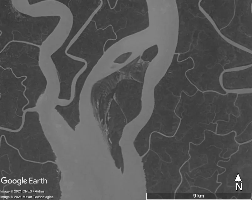
FIGURE 1.1. Example of char formation in the Sundarbans; image taken in 1984.
Source: Google Earth.
In the Sundarban region, the extent and variety of the lands that were categorized as waste offered ample scope for colonial administrators to devise methods of “scientifically,” politically, and physically managing the landscape. As one administrator observed, “This wilderness and labyrinth of rivers [was] the property of no landholder, but of the [colonial] sovereign,” and thus cultivation and extraction could be undertaken on the basis of this sovereignty over wasteland (Hamilton 1820, 126). In addition to being home to extensive forested areas (which made up the majority of wastelands throughout British India), the chars and diaras (alluvial sediment deposits that gradually develop into new land masses) were also classified as wasteland (Lahiri-Dutt and Samanta 2013). Figures 1.1 and 1.2 depict an example of the gradual formation of such alluvial land masses in the Sundarbans in the last several decades. The classification of the Sundarbans as waste was also claimed by colonial administrators as cause for excluding the region from the Permanent Settlement, thus establishing the government’s indefinite right to profit from all resources extracted from the area (Iqbal 2010; Pargiter 1934).
Accumulation
If the Sundarbans have been framed in colonial and postcolonial imaginaries as wild and remote, their position in global political economies has been anything but marginal. The region’s unstable ecological and biophysical features have in many ways undermined attempts at governance and accumulation. As successive development regimes have sought greater control over the landscape, these environmental challenges have stoked dystopic imaginaries of the region.
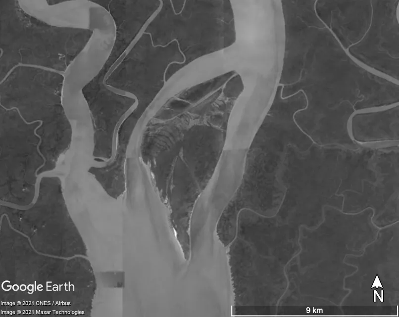
FIGURE 1.2. Example of char formation in the Sundarbans; image taken in 2020.
Source: Google Earth.
The British East India Company established its primary port and trading base in Kolkata (then Calcutta) in the late seventeenth century, and Kolkata subsequently became the capital of the British Raj. The Port of Calcutta became the most important port in British India, with all shipping traffic routed through the Sundarbans (Hunter 1875a, 16), leading one colonial observer to refer to the Sundarbans as “the British emporium of the East” (Bull 1823, 124). The growing significance of these shipping routes contributed to the importance of Calcutta as a commercial city and increased the power of British political and economic control in India (Mukerjee 1938, 26). The 1908 Khulna Gazetteer referred to these shipping routes as “one of the most important systems of inland navigation in the world,” with trafficked goods valued at nearly 4 million pounds sterling annually, equivalent to about US$600 million today (O’Malley 1908, 128). The town of Khulna, located just north of the forested area of the Sundarbans, was an important node in this network, serving as the headquarters of the...
Table of contents
- Acknowledgments
- List of Acronyms
- Introduction
- 1. “Sluttish, Careless, Rotting Abundance”
- 2. Threatening Dystopias
- 3. Opportunity/Crisis
- 4. The Social Life of Climate Science
- 5. Autopsy of a Village
- 6. “We Have Come This Far—We Cannot Retreat”
- Conclusion
- Methodological Appendix
- Glossary
- Notes
- Bibliography
- Index
Frequently asked questions
Yes, you can cancel anytime from the Subscription tab in your account settings on the Perlego website. Your subscription will stay active until the end of your current billing period. Learn how to cancel your subscription
No, books cannot be downloaded as external files, such as PDFs, for use outside of Perlego. However, you can download books within the Perlego app for offline reading on mobile or tablet. Learn how to download books offline
Perlego offers two plans: Essential and Complete
- Essential is ideal for learners and professionals who enjoy exploring a wide range of subjects. Access the Essential Library with 800,000+ trusted titles and best-sellers across business, personal growth, and the humanities. Includes unlimited reading time and Standard Read Aloud voice.
- Complete: Perfect for advanced learners and researchers needing full, unrestricted access. Unlock 1.5M+ books across hundreds of subjects, including academic and specialized titles. The Complete Plan also includes advanced features like Premium Read Aloud and Research Assistant.
We are an online textbook subscription service, where you can get access to an entire online library for less than the price of a single book per month. With over 1.5 million books across 990+ topics, we’ve got you covered! Learn about our mission
Look out for the read-aloud symbol on your next book to see if you can listen to it. The read-aloud tool reads text aloud for you, highlighting the text as it is being read. You can pause it, speed it up and slow it down. Learn more about Read Aloud
Yes! You can use the Perlego app on both iOS and Android devices to read anytime, anywhere — even offline. Perfect for commutes or when you’re on the go.
Please note we cannot support devices running on iOS 13 and Android 7 or earlier. Learn more about using the app
Please note we cannot support devices running on iOS 13 and Android 7 or earlier. Learn more about using the app
Yes, you can access Threatening Dystopias by Kasia Paprocki in PDF and/or ePUB format, as well as other popular books in Biological Sciences & Indian & South Asian History. We have over 1.5 million books available in our catalogue for you to explore.