True stories, fun facts, and photos that reveal the little-known secrets of New York's Long Island.
Long Island's history is filled with fascinating firsts, magnificent mansions, and colorful characters. From Glenn Curtiss, the first pilot to fly a plane on the island, to Earle Ovington, who carried the country's first airmail, the area has been known as the cradle of aviation. Millionaire William K. Vanderbilt's Long Island Motor Parkway, remnants of which still remain, was the nation's first highway. The desolate ruins of an exiled Albanian king's estate lie in the midst of the woods of the Muttontown Preserve. Captain William Kidd, pirate chaser turned pirate, is rumored to have buried treasure on the island. With these stories and more, Richard Panchyk reveals the rapidly vanishing traces of Long Island's intriguing history.
"Amazing and unknown historical gems."—
Queens Gazette
- 195 pages
- English
- ePUB (mobile friendly)
- Available on iOS & Android
eBook - ePub
Hidden History of Long Island
About this book
Trusted by 375,005 students
Access to over 1.5 million titles for a fair monthly price.
Study more efficiently using our study tools.
Information
Chapter 1
THE GLACIER STOPS HERE!
The first important event in Long Island’s history happened around twenty thousand years ago, long before any humans set foot there. It was a time in geological history known as the Wisconsin Glaciation, the so-called Ice Age. Glaciers had advanced from the north, covering all of Canada and parts of at least twenty-four states with ice. Geographically, Long Island is a very special place, because it marks the southernmost point of glacial advancement. As the glaciers advanced, they accumulated boulders, rocks and earth and pushed this debris along. The point where they stopped advancing and began to melt is known as the terminal moraine, and Long Island has two of them, formed at different times: the younger Harbor Hill Moraine, skirting along the northern coast of Long Island; and the Ronkonkoma Moraine, running almost parallel but farther south.
The locations of these terminal moraines are marked by the island’s lines of hills, including Suffolk County’s highest point, the 401-foot-high Jayne’s Hill (also known as High Hill, part of the Ronkonkoma Moraine) in Melville, and Nassau’s highest point, Harbor Hill in Roslyn, at 348 feet (part of the Harbor Hill Moraine).
But creating Long Island’s hills was not the only effect of the glaciers. As the ice melted, streams of runoff water flowed south toward the Atlantic, bringing tons of fine sediment with it and forming a flat outwash plain, comprising most of southern Long Island and accounting for the existence of the Hempstead Plains and the southern beaches.
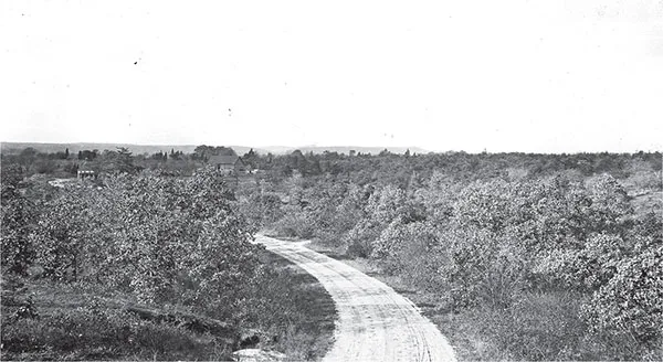
Looking north from south of Melville toward the Ronkonkoma Moraine and High Hill (aka Jayne’s Hill), 1917. United States Geological Survey.
When chunks of the front of the glaciers broke off, they formed depressions, what are known as kettle holes. Many of these filled with water and became kettle lakes or ponds. Many such water bodies are scattered across Long Island, the largest being Lake Ronkonkoma, three-fourths of a mile in diameter, and the seventy-five-foot-deep Lake Success in the Nassau County village of the same name.
In this chapter and throughout the book, we’ll find out how the Ice Age’s impact on Long Island’s geography affected its development and allowed for some fascinating moments in history.
SHELTER ROCK
During the last Ice Age, sometime between ten thousand and twenty thousand years ago, an advancing glacier—let’s call it Derek—encountered a gigantic granite boulder in what is now Westchester County. Though the boulder was large, Derek was much larger, and as he moved, he carried the boulder along with him several miles to the southeast, depositing it in what would become the town of North Hills, on Nassau County’s North Shore. Now, glaciers moving boulders was a frequent Ice Age occurrence, but this boulder is quite special. Known as Shelter Rock and marked by a sign, it is the largest boulder on Long Island and possibly the largest in New York State. At five million pounds (eighteen hundred tons), the so-called glacial erratic measures fifty-five feet high by forty feet wide by sixteen feet deep and is located a mere forty feet off the southbound side of Shelter Rock Road, just south of Northern Boulevard (Route 25A). The “new” arrival was likely already five hundred million years old when Derek the Glacier brought this large metamorphic present to Long Island.
Despite its importance, not many people are aware of its existence. First, the sheer size of this boulder is hidden from sight because it lies in a valley twenty feet below the road. Second, it is on private property behind a fence, hidden by shrubs and trees.
The rock, also known as Milestone Rock and Manhasset Rock, got the name Shelter Rock due to its generous thirty-foot by twelve-foot overhang, which offers space enough for several people to receive shelter from wind and rain. But was there any proof that it was used for that purpose? An archaeological excavation for the American Museum of Natural History in 1946 found evidence of Native American presence dating to 1000 BC, making it one of the oldest human habitation sites ever found on Long Island. The site yielded twenty-seven projectile points, pieces of stone knife blades, pottery sherds, shell and animal bone fragments and several hammer stones used by the Matinecocks, who belonged to the Algonquin tribe.
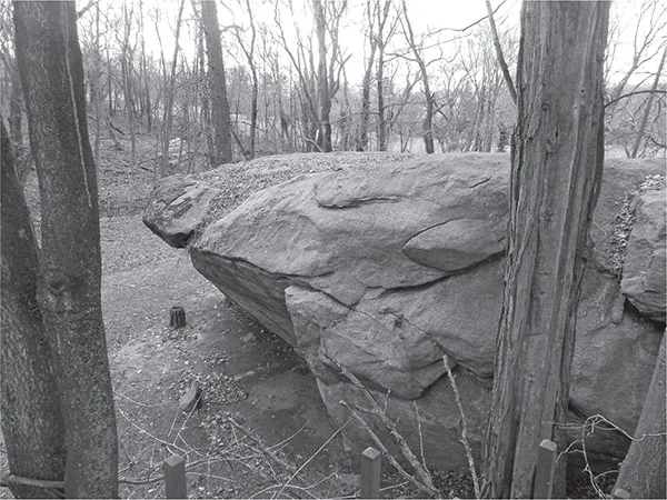
Shelter Rock. Author’s collection.
There are a few legends associated with Shelter Rock. One of them tells of a young soldier running off with an Indian maiden, but he was shot with arrows before he could reach the overhang. Shelter Rock was also rumored to be the site of Captain Kidd’s buried treasure. According to lore, the pirate lifted the giant boulder and dug a hole under the rock, depositing some of his booty there.
Shelter Rock was located on farmland until 1899, when the wealthy businessman Oliver Hazard Payne bought the land upon which it sits and left it to his nephew Payne Whitney, who died in 1927. Payne Whitney’s son John Hay Whitney inherited the estate. J.H. Whitney, a major supporter of Dwight Eisenhower, was appointed U.S. ambassador to the United Kingdom. He also served as president of the Museum of Modern Art. Upon his death in 1982, the estate went to his widow, Betsey Cushing Roosevelt Whitney. In 1998, after the death of Mrs. Whitney, there was concern about the future of the property. What would happen to Shelter Rock if the property was sold? In the end, the property went to the Whitney family’s Greentree Foundation, which had been founded in 1982. Greentree is a nonprofit, and the estate is now a conference center. The giant rock is safe for now, a hidden treasure that is barely visible by the thousands of drivers who pass by every day.
OTHER FAMOUS BOULDERS
Other glacial boulders made history on Long Island, too.
Council Rock, located on Lake Avenue just west of Oyster Bay Village, had its claim to fame in 1672, when the father of the Quaker movement, George Fox, arrived by ship at Oyster Bay and preached at a large boulder in the woods. The site was chosen because there was no building large enough to accommodate the crowd. (Later that year, one of the townsmen offered part of his land for the construction of a meetinghouse.) The boulder, located south of West Main Street, is noted by a historical marker. A second famous boulder also known as Council Rock sits just outside the Fort Hill Cemetery in Montauk, formerly the site where the Montauk Indians held tribal meetings.
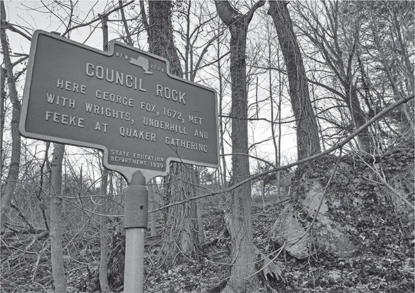
Council Rock. Author’s collection.
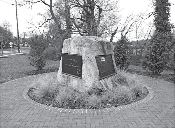
The Nathan Hale Rock in Huntington. Author’s collection.
Another famous Long Island boulder sits at a traffic circle near the intersection of Mill Dam Road and New York Avenue in Huntington. The monument to Revolutionary War hero Nathan Hale was the creation of George Taylor, a resident who owned the land where the Patriot spy landed in 1776 after crossing the Long Island Sound from his native Connecticut and was captured by the British. Hale was taken to New York City and hanged there. Fascinated with Hale’s story, Taylor had a boulder moved from near his house to closer to the beach to serve as a remembrance of Hale’s landing spot. Affixed with commemorative plaques, the boulder remained in the Taylor family until the 1970s, when a descendant gave it to the Town of Huntington, which had the forty-five-ton boulder moved to its current location. Almost. Hale’s boulder had to move again in 2012 when the roadway was reconstructed, to a spot about fifty feet from where it had been. The irony of this story is that, just like Hale, the boulder originated in Connecticut, though it was carried to Long Island by a slightly larger vehicle than Hale’s boat—a glacier.
THE REMAINS OF THE HEMPSTEAD PLAINS
When you think of prairie, images of a certain little house in Kansas come to mind. The Great Plains are thousands of miles from Long Island, right? The answer is a resounding: No!
In fact, the only true prairie east of the Appalachian Mountains was located on Long Island. Though it is hard to imagine now, just a few hundred years ago, a sixty-thousand-acre grassland covered central Nassau County, extending from New Hyde Park all the way to Hicksville. It was formed by glacial outwash more than ten thousand years ago during the last Ice Age.
This flat land had a variety of uses over the last four hundred years. With its rich soil, the land was a good place to graze cattle and sheep and grow various grains. It also had a variety of sporting uses.
Horse races were quite popular in colonial days (see chapter 5). Hunting was another popular plains sport. There were a tremendous number of bird species that lived on or migrated to the plains. Daniel Tredwell, who kept a journal of his nineteenth-century Long Island adventures, wrote of a Hempstead Plains hunt that took place one day in 1843. His party shot eighty-two birds that Saturday and then went to the Hewlett Hotel, where they cooked up a bunch of the birds for dinner.
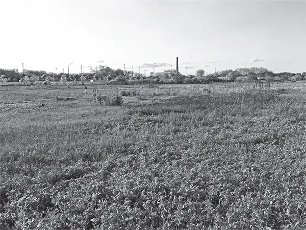
The remains of the Hempstead Plains, Uniondale. Author’s collection.
With settlement, the plains began to shrink and change. An 1824 book said that “cultivation is gradually encroaching upon it, around the borders.” One of the biggest factors in the disappearance of the Hempstead Plains was a man named Alexander T. Stewart. In 1869, Stewart bought seven thousand acres from the Town of Hempstead for $395,000 to create Garden City. Over the next several years, work was begun on transforming this grassland into a town. Stewart died in 1876, before his vision was fully implemented, but his widow, Cornelia, carried his plans through.
By the beginning of the twentieth century, there was still a considerable swath of plains left intact, just in time for a new use that would thrust this wilderness into the modern world: the airplane.
The flat stretch of land extending several miles was an ideal place for early aviators to set up airfields and experiment with the new technology that had been proven by the Wright brothers in North Carolina just a few years earlier. By 1909, aviation pioneer Glenn Curtiss was flying from Mineola, and within a few years, the area had cemented its status as the “Cradle of Aviation” (see chapter 4). By the 1920s, there were several airfields extending from Westbury west and south through what is now Mineola, Garden City and Uniondale. The series of fields was perfect as a “hopping ground,” allowing planes to take off and land (or crash-land, as it were) in a relatively safe way, far from populated areas.
As the airfields became more sophisticated, more of the plains were reclaimed by runways and pavement, though there were areas surrounding the runways that were still undeveloped grasslands. A 1937 article explained: “The plain is still there but it has lost a great deal of its significance since the countryside has been cut up with roads and cross roads and thousands of small houses dot the landscape.”
Things changed again with the closing of the airfields in the 1940s and 1950s. The land was developed; Roosevelt Field Mall, the Source Mall, Hofstra University, Nassau Coliseum and the Marriott now occupy what had fairly recently been airfields and grasslands.
By 1970, the extent of the Hempstead Plains was less than one thousand acres. Nassau County preserved about sixty-two acres as a park that year, but the land was not maintained as a true prairie. What is left of the plains are two small areas. One is a strip of land adjacent to the Nassau Community College campus that is maintained by the Friends of the Hempstead Plains. Keeping the plains intact requires tremendous effort. Invasive, nonnative plant species would run rampant and take over the area without constant weeding and tending. There are 250 different types of plants that still exist on the plains.
The other remaining piece is a small strip that runs along the northern edge of Eisenhower Park. Interestingly, the only reason that bit of plains still exists is that it was part of the “rough” of the famous Red Golf Course in the park. The Red Course was designed in 1914 as one of five courses in the Salisbury Country Club. When the club went bust in the 1930s, the county took over the land and created what is now Eisenhower Park (then known as Salisbury Park). Four of the courses were scrapped, but the northernmost, Red Course, was retained, along with its accompanying strip of prairie.
TWO LAKES, TWO LEGENDS
Lake Success and Lake Ronkonkoma, both created during the Ice Age, have been the subject of fascination and legend for countless years. Both lakes are fairly deep and were thought to be bottomless until the nineteenth century, when they were finally measured.
Lake Ronkonkoma
It was alleged that objects dropped into Lake Ronkonkoma made their way through subterranean chambers into the Great South Bay and the Atlantic Ocean. This notion has since been proven false. Eighteenth- and nineteenth-century settlers also heard stories about a ghostly Indian girl (“The Lady of the Lake”) who haunted the lake and took a male victim once a year. According to the tales, the Lady would call her victims and lure them into the deeper waters, and then the unlucky boys would be found drowned some time later.
Lake Success
A bizarre legend about Lake Success originated about two hundred years ago, when a boy named Harry went fishing at the deepest part of Lake Success and reeled in not a fish but a woman, with the hook in her lip. The beautiful young woman said to the stunned boy: “Harry, Harry, cut the line, and permit me to descend, for I am not mortal but a Naiad, who reside in the deepest recesses of the pond.” Harry had other ideas, however, and thought he could put her on display, charge admission and make a fortune. When she saw he was not going to let her go, she pulled the line out herself and said angrily: “You fool, since you will not benefit those whom Providence places within your influence, no man shall be able to benefit you.” Undaunted, the boy shook off this prediction and went home and p...
Table of contents
- Front Cover
- Half Title
- Title Page
- Dedication
- Copyright
- Contents
- Introduction
- Chapter 1: The Glacier Stops Here!
- Chapter 2: Long Island at War
- Chapter 3: Pirates, Presidents, Poets and Preachers
- Chapter 4: Rails, Roads and Runways
- Chapter 5: Horses and Courses
- Chapter 6: Ghosts of the Gold Coast
- Chapter 7: Final Resting Places
- Selected Bibliography
- About the Author
Frequently asked questions
Yes, you can cancel anytime from the Subscription tab in your account settings on the Perlego website. Your subscription will stay active until the end of your current billing period. Learn how to cancel your subscription
No, books cannot be downloaded as external files, such as PDFs, for use outside of Perlego. However, you can download books within the Perlego app for offline reading on mobile or tablet. Learn how to download books offline
Perlego offers two plans: Essential and Complete
- Essential is ideal for learners and professionals who enjoy exploring a wide range of subjects. Access the Essential Library with 800,000+ trusted titles and best-sellers across business, personal growth, and the humanities. Includes unlimited reading time and Standard Read Aloud voice.
- Complete: Perfect for advanced learners and researchers needing full, unrestricted access. Unlock 1.5M+ books across hundreds of subjects, including academic and specialized titles. The Complete Plan also includes advanced features like Premium Read Aloud and Research Assistant.
We are an online textbook subscription service, where you can get access to an entire online library for less than the price of a single book per month. With over 1.5 million books across 990+ topics, we’ve got you covered! Learn about our mission
Look out for the read-aloud symbol on your next book to see if you can listen to it. The read-aloud tool reads text aloud for you, highlighting the text as it is being read. You can pause it, speed it up and slow it down. Learn more about Read Aloud
Yes! You can use the Perlego app on both iOS and Android devices to read anytime, anywhere — even offline. Perfect for commutes or when you’re on the go.
Please note we cannot support devices running on iOS 13 and Android 7 or earlier. Learn more about using the app
Please note we cannot support devices running on iOS 13 and Android 7 or earlier. Learn more about using the app
Yes, you can access Hidden History of Long Island by Richard Panchyk in PDF and/or ePUB format, as well as other popular books in History & North American History. We have over 1.5 million books available in our catalogue for you to explore.