A comprehensive collection of Civil War maps and battle plans that brought Union and Confederate forces to the largest battle ever fought on American soil.
Thousands of books and articles have been written about Gettysburg—but the military operation itself remains one of the most complex and difficult to understand. Here, Bradley M. Gottfried gives readers a unique and thorough study of the campaign that decided the fate of a nation.
Enriched with 144 detailed, full-page color maps comprising the entire campaign,
The Maps of Gettysburg shows the action as it happened—down to the regimental and battery level, including the marches to and from the battlefield, and virtually every significant event in-between. Paired with each map is a fully detailed text describing the units, personalities, movements, and combat it depicts—including quotes from eyewitnesses—all of which bring the Gettysburg story to life.
Perfect for the armchair historian or first-hand visitor to the hallowed ground, "no academic library can afford not to include
The Maps of Gettysburg as part of their American Civil War Reference collections" (
Midwest Book Review).
eBook - ePub
The Maps of Gettysburg
An Atlas of the Gettysburg Campaign, June 3–July 13, 1863
- 384 pages
- English
- ePUB (mobile friendly)
- Available on iOS & Android
eBook - ePub
The Maps of Gettysburg
An Atlas of the Gettysburg Campaign, June 3–July 13, 1863
About this book
Trusted by 375,005 students
Access to over 1.5 million titles for a fair monthly price.
Study more efficiently using our study tools.
Information
Topic
HistoriaThe Battle of Gettysburg
Map Set 4: The Initial Fighting West of Gettysburg, North of Chambersburg Pike
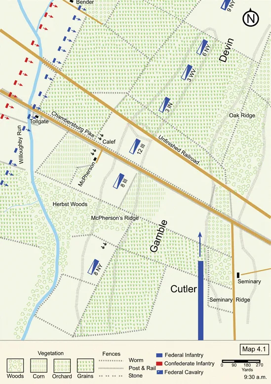
Map 4.1 (July 1)
Major General Henry Heth’s Division, led by Maj. William Pegram’s artillery battalion, set out for Gettysburg about 5:00 a.m. on July 1. Heth suspected a Federal force occupied the town, but did not know its character or strength. Regardless, he intended to push it away and enter the town on reconnaissance.
Watching for Heth just east of Marsh Creek were videttes of Brig. Gen. John Buford’s First Cavalry Division. Buford occupied Gettysburg with two brigades under Cols. William Gamble and Thomas C. Devin, slightly more than 2,700 troopers. Buford’s third brigade under Brig. Gen. Wesley Merritt was still near Mechanicstown, Maryland, guarding his trains and watching the mountain passes. When the head of Heth’s column reached Marsh Creek, one of Buford’s men fired—the discharge was the first shot of the battle.1
The opening fire prompted Gamble to send more men from his regiments to the reserve line along Herr Ridge and to the west to reinforce his skirmishers. They dismounted, and every fourth man led the horses back to McPherson Ridge. Heth sent out a skirmish line both north and south of the Chambersburg Pike, which outnumbered Buford’s men 5 to 1. Pushed heavily on the front and flanks, Gamble’s troopers (assisted by some of Devin’s men) waged a fighting withdrawal toward Herr Ridge. Pegram’s cannons unlimbered and added their metal to the mismatch developing west of town. Heth held a firm advantage in both numbers and firepower, but the sharp resistance offered by Buford’s troopers slowed his advance to a crawl.2
The Federal skirmishers gave ground stubbornly for about one and one-half miles while Buford readied the rest of his men on McPherson Ridge. His artillery consisted of one battery of six 3-inch ordnance rifles under Lt. John Calef. This “flying artillery” was lighter and more mobile than the guns associated with the infantry. Calef had spent the prior evening near the Lutheran Seminary south of Chambersburg Pike. To give the impression of strong artillery support, Buford ordered Calef to disperse his guns. One section under Lt. John Roder deployed on McPherson Ridge north of Chambersburg Pike. A second section under Sgt. Joseph Newman dropped trail on the opposite side of the road near the McPherson farm. The last section, under Sgt. Charles Pergel, unlimbered in the southeast corner of McPherson Woods.3
Colonel Gamble’s brigade held Buford’s left half of his line. Gamble positioned the 3rd Indiana (six companies) to the right of the unfinished railroad cut north of Chambersburg Pike. The 12th Illinois (four companies) occupied the area between the cut and the road. Colonel George Chapman of the 3rd Indiana commanded both regiments. The 8th Illinois deployed between the road and McPherson Woods, and the 8th New York anchored the left of the line just south of the woods. Colonel Devin’s brigade was deployed north of the railroad cut, aligned from left to right as follows: 3rd West Virginia – 6th New York – 9th New York – 17th Pennsylvania. The right flank of the 17th Pennsylvania covered the Mummasburg Road.4
Heth’s skirmishers, eight companies from Brig. Gen. James Archer’s Brigade, approached McPherson Ridge. Buford reinforced his line and the fighting intensified. Heth responded by deploying more men from Archer’s and Brig. Gen. Joe Davis’ brigades, now moving in battle line. The rest of the division waited in column along the road. When it became obvious the fight was more than he was expecting, Heth deployed the balance of his first two infantry brigades. It was about 9:30 a.m. Davis’ men fell into line north of Chambersburg Pike; Archer’s infantry regiments formed south of the road.5
As Heth’s infantry began their slow advance upon McPherson Ridge, the First Brigade of Maj. Gen. John Reynolds’ I Corps, commanded by Brig. Gen. Lysander Cutler, arrived on the field and quickly approached Chambersburg Pike. Buford and his men had masterfully completed their task.
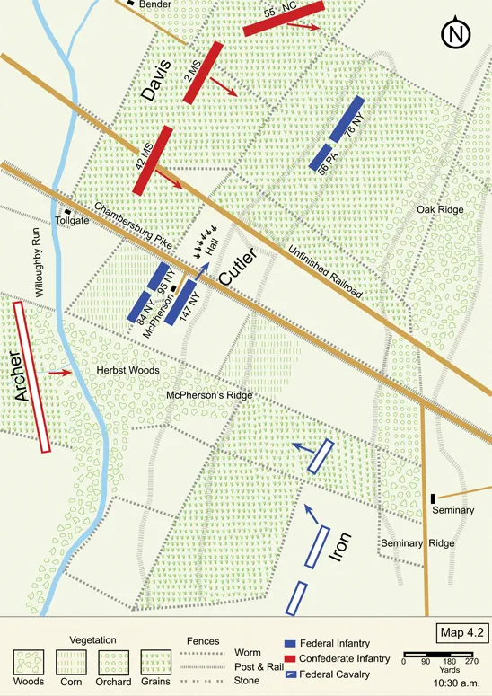
Map 4.2
John Reynolds’ I Corps led the Union Army’s march to Gettysburg on July 1, and Brig. Gen. Lysander Cutler’s brigade led the I Corps. As they approached the Codori house along the Emmitsburg Road, the men left the road and angled northwest, cutting across fields and knocking down fences as they tramped. Artillery fire from Lt. John H. Calef’s Battery A, 2nd U.S. Artillery, was clearly audible and served to quicken their pace. The first two regiments in the brigade’s column, the 76th New York and 56th Pennsylvania, crossed Chambersburg Pike. In its haste to relieve sections of Calef’s battery north of the road, Captain James Hall’s six-gun 2nd Maine battery made a sudden dash between the 56th Pennsylvania and the next regiment in line, the 147th New York. The result was that the latter regiment remained on the south side of Chambersburg Pike with the 84th and 95th New York near the McPherson farm buildings. Hall’s battery finally dropped trail between Chambersburg Pike and the unfinished railroad while Calef’s guns withdrew to the Lutheran Theological Seminary, where the men rested and restocked their ammunition. As Cutler’s men took up their new positions, Maj. William Pegram’s Confederate artillery battalion on Herr Ridge hurled shells in their direction. Casualties appeared almost immediately.6
As the six hundred Federal infantry of the 76th New York and 56th Pennsylvania continued moving north from the unfinished railroad cut, 1,700 men in the 2nd Mississippi, 42nd Mississippi, and 55th North Carolina of Brig. Gen. Joseph Davis’ Brigade rapidly approached from the west. These were large regiments, each numbering more than 500 men, but only the 2nd Mississippi had significant combat experience. The three regiments were part of Heth’s Division of A. P. Hill’s Third Corps, and had marched behind Brig. Gen. James Archer’s Brigade on Chambersburg Pike as they approached Gettysburg. Archer deployed on the right (south) of the road, while Davis formed his regiments into line of battle on Archer’s left. Davis’ entire sizable command numbered 2,300 muskets, but the 11th Mississippi was in the rear guarding the trains. At about 10:30 a.m., with the veteran 2nd Mississippi in the middle of the line and the two inexperienced regiments deployed on either side—the 55th North Carolina on the left flank and the 42nd Mississippi on the right—the brigade advanced about one mile preceded by a skirmish line. The 55th North Carolina began curving its march to the northeast as it passed the Bender farm.7
Davis’ men suddenly materialized in the wheat fields in front of the 76th New York and 56th Pennsylvania as the Federal troops reached their positions north of the unfinished railroad cut. General Cutler reported that the enemy was “advancing in two lines, at short range, in front and on my right flank." Although second in line, the 56th Pennsylvania completed its deployment from column into line of battle before the 76th New York to its right. Seeing troops in front of him, Col. William Hofmann of the 56th Pennsylvania asked General Cutler, “Is that the enemy?" Cutler, who had been watching the movements through his binoculars, answered in the affirmative. Hofmann yelled to his men, “Ready, Right Oblique! Aim! Fire!" The rounds struck two members of the 55th North Carolina’s color guard—the first recorded shots fired by Federal soldiers during the battle.
The 2nd Mississippi and 55th North Carolina quickly responded. The men leveled their weapons and fired, killing and wounding an unrecorded number of Pennsylvanians. Still moving into position, the 76th New York received a raking fire and several men fell. Unable to see any enemy soldiers, its commanding officer, Maj. Andrew Grover, assumed the fire was coming from Federal troops and ordered his New Yorkers to hold their fire. Another volley ripped through his line. Grover, still unconvinced of the source, continued cautioning his men to hold their fire. When he finally spotted the 2nd Mississippi rising out of the fields in front of him, the major ordered his embattled men to defend themselves.8
Map 4.3
Seeing the right flank of the 76th New York hanging in the air, Col. John Connelly grabbed the flag of his 55th North Carolina as the regiment continued its wheeling movement. With a yell he rushed toward the enemy with his color guard in tow. The advancing colors drew the New Yorkers’ attention, and Connelly quickly suffered a debilitating wound. The regiment’s second in command rushed over to Connelly, who told him, “Take the colors and keep ahead of the Mississippians.” Recognizing the threat to his right flank, Major Grover ordered the right wing of his 76th New York to “change front to the rear,” which refused the right flank to face the 55th North Carolina. The left side of the regiment continued facing the 2nd Mississippi and that part of the 55th North Carolina in front of it. Grover fell with a mortal wound almost as soon as he gave the order. Few men saw their leader fall as they were too busy firing at the approaching enemy troops, who were sending gunfire into the 76th’s front, flank, and rear.9
The 147th New York crossed Chambersburg Pike and, seeing the enemy closing in on Hall’s battery, quickly advanced to a wheat field just north of the unfinished railroad cut, approximately 100 yards in advance (west) of the position held by the 56th Pennsylvania and 76th New York. The 42nd Mississippi, Davis’ leading regiment, fired volley after volley into the newly arrived Federal troops. In an effort to stay alive, many of the New Yorkers slid down into the wheat to reload, rose quickly to fire, and repeated the cycle. As a result, those who were struck were usually hit in the upper body, where wounds tended to be more serious. A thick layer of smoke enveloped the area and visibility diminished considerably.10
Realizing that his men were in an untenable position with their entire right flank exposed, division commander Maj. Gen. James Wadsworth ordered them to pull back 300 yards to Sheads’ Woods. The 76th New York and 56th Pennsylvania lost heavily during their twenty minutes on the ridge. The former left about 62% on the field, and the latter about 50%. A line of dead and wounded marked their original line of defense.11
Because of the smoke, deafening sound, and confusion, Lt. Col. Francis Miller of the 147th New York was unaware of the retreat of the two Federal regiments. He also did not know that he had both the 42nd Mississippi approaching obliquely against his front and the 2nd Mississippi advancing nearly perpendicular to his exposed right flank. His situation grew even more critical when Davis’ third regiment, the 55th North Carolina, finished wheeling about and moved against the right-rear of the isolated New Yorkers. General Wadsworth quickly sent an aide to Miller, ordering him to pull the regiment back to safety, but Miller went down with a severe wound before he could comply. Major George Harney displayed sound tactics when he refused the right companies to take on the new threat from the north, though to no avail. According to one survivor, “the boys on the right were falling like autumn leaves; the air was full of lead.” Another messenger from Wadsworth arrived and ordered a...
Table of contents
- CoverPage
- Title
- CopyrightPage
- DedicationPage
- Map
- Contents
- List of Maps
- Introduction
- The Army of Northern Virginia Moves North
- The Confederates Clear the Valley
- The Battle of Gettysburg
- Withdrawal to Virginia
- Appendix A: Order of Battle
- Notes
- Bibliography
- About the Author
Frequently asked questions
Yes, you can cancel anytime from the Subscription tab in your account settings on the Perlego website. Your subscription will stay active until the end of your current billing period. Learn how to cancel your subscription
No, books cannot be downloaded as external files, such as PDFs, for use outside of Perlego. However, you can download books within the Perlego app for offline reading on mobile or tablet. Learn how to download books offline
Perlego offers two plans: Essential and Complete
- Essential is ideal for learners and professionals who enjoy exploring a wide range of subjects. Access the Essential Library with 800,000+ trusted titles and best-sellers across business, personal growth, and the humanities. Includes unlimited reading time and Standard Read Aloud voice.
- Complete: Perfect for advanced learners and researchers needing full, unrestricted access. Unlock 1.5M+ books across hundreds of subjects, including academic and specialized titles. The Complete Plan also includes advanced features like Premium Read Aloud and Research Assistant.
We are an online textbook subscription service, where you can get access to an entire online library for less than the price of a single book per month. With over 1.5 million books across 990+ topics, we’ve got you covered! Learn about our mission
Look out for the read-aloud symbol on your next book to see if you can listen to it. The read-aloud tool reads text aloud for you, highlighting the text as it is being read. You can pause it, speed it up and slow it down. Learn more about Read Aloud
Yes! You can use the Perlego app on both iOS and Android devices to read anytime, anywhere — even offline. Perfect for commutes or when you’re on the go.
Please note we cannot support devices running on iOS 13 and Android 7 or earlier. Learn more about using the app
Please note we cannot support devices running on iOS 13 and Android 7 or earlier. Learn more about using the app
Yes, you can access The Maps of Gettysburg by Bradley M. Gottfried in PDF and/or ePUB format, as well as other popular books in Historia & Historia de la Guerra de Secesión. We have over 1.5 million books available in our catalogue for you to explore.