"A vivid reminder of the ever-present threat of a global apocalypse that formed the backdrop to the Cold War. This is an excellent book." —
History of War
Medieval castles, the defensive systems of the seventeenth, eighteenth and nineteenth centuries, the trenches and bunkers of the First World War, the great citadels of the Second World War—all these have been described in depth. But the fortifications of the Cold War—the hidden forts of the nuclear age—have not been catalogued and studied in the same way. Paul Ozorak's
Underground Structures of the Cold War: The World Below fills the gap.
After the devastation caused by the atom bombs dropped on Hiroshima and Nagasaki and the outbreak of the Cold War, all over the world shelters were constructed deep underground for civilians, government leaders and the military. Wartime structures were taken over and adapted and thousands of men went to work drilling new tunnels and constructing bunkers of every possible size. At the height of the Cold War, in some countries an industry of bunker-makers profited from the public's fear of annihilation.
Paul Ozorak describes when and where these bunkers were built, and records what has become of them. He explains how they would have been used if a nuclear war had broken out, and in the case of weapons bases, he shows how these weapons would have been deployed. His account covers every sort of facility—public shelters, missile sites, command and communication centers, storage depots, hospitals.
A surprising amount of information has appeared in the media about these places since the end of the Cold War, and Paul Ozorak's book takes full advantage of it.
- 362 pages
- English
- ePUB (mobile friendly)
- Available on iOS & Android
eBook - ePub
About this book
Trusted by 375,005 students
Access to over 1.5 million titles for a fair monthly price.
Study more efficiently using our study tools.
Information
Print ISBN
9781848844803
Subtopic
Military & Maritime History❑ UNITED STATES
Continuity of Government
In the 1964 film Seven Days in May, Burt Lancaster plays a right-wing Chairman of the Joint Chiefs of Staff bent on taking over the United States government from what he considers to be a weak-kneed White House. His plan is to lock up the President in a bunker built to house senior government staff in case of nuclear war at a time when the White House staff was to be relocated there briefly for a nuclear drill. The film was based on a novel of the same name by Fletcher Knebel and Charles Bailey and was possibly the first time anyone outside the government mentioned the possibility of such bunkers. This inevitably gave rise to speculation about whether such facilities really existed.
It is no longer a secret that the United States government has in fact built several bunkers around the District of Columbia to house personnel during a nuclear war. The role of this personnel is to provide continuity to government. It was revealed years ago that if the panic button was ever pressed, senior American government officials, including the President and White House staff, Cabinet secretaries and Supreme Court judges, would have quickly relocated to a large bunker at Mount Weather near Bluemont, Virginia. From this secret post, which was codenamed ‘High Point’, democracy would supposedly have continued.
The secret Mount Weather facility was built in the 1950s by the US Army Corps of Engineers as a small city in its own right. Essentially, it consists of two major sections: an above-ground town and the bunker, known as Areas A and B respectively. The latter was built as a set of buildings inside caverns that house dormitories, cafeterias, hospital, an operations centre and various offices. The bunker was built to withstand 50psi of pressure, although studies have shown it could still be disabled by a small number of 10 megaton bombs. Every item imaginable is stored there: large stocks of food, government stationery and even birth control pills. A medical lockup with padded walls was even built for those who would not be able to stand the strain. To repel those trying to force their way in, security personnel in the bunker keep several firearms on hand; even relatives of bunker occupants would be scared away. At 200,000sq ft, the entire shelter can hold approximately 1,000.1 During emergencies, personnel would travel to the complex by cars or buses or, if they were senior enough, by helicopter. In addition to calling the complex ‘High Point’, government documents have also referred to it as the ‘Special Facility’ and the ‘Western Virginia Office of Controlled Conflict Operations’. Nowadays, the entire property is known as the Mount Weather Emergency Assistance Center and is run by the Federal Emergency Management Agency (FEMA).
How would High Point swing into action during a war? Government officials designated to live there during and after an attack have their movements tracked on a daily basis so that when the call is sounded, all could be contacted and ordered to report to the bunker, dependants excluded, following procedures outlined in the Joint Emergency Evacuation Plan. The President’s original taxi service, the USAF’s 2857th Test Squadron at Olmsted AFB in Harrisburg, Pennsylvania (and later at Dover AFB, Delaware), was kept on stand-by twenty-four hours a day by a specially trained crew equipped with, among other things, radiation protection gear. These days, the President would not relocate to Mount Weather but would board a special 747 airliner outfitted as an airborne command post. His successors (e.g. the Vice-President, the Senate leader etc.) would relocate to various command centres, including Mount Weather, with teams of special personnel under a plan called ‘Treetop’. The fact the President will no longer move to High Point during a war may be because at least one President, John F. Kennedy, has been quoted as saying he would not have gone there and leave his family behind if the Soviet Union ever attacked, or it may be because the facility is so well known that any President relocating there would be a sitting duck.
With a grid of sensors located across the country, technicians at Mount Weather can tell from an electronic map in the ‘Bomb Alarm’ room where nuclear detonations take place and can respond accordingly. Fallout can be tracked through V-781 Aerial Survey Meters deployed across the country. After the Secretary of the Army was designated the chief civil defence support officer, it befell the Army to form support detachments ready to aid with communications and bunker security. Every facet of modern civilization was considered in the war plan: the mail, the banking system, utilities and the press. The church is relied upon for mass burials and, in rural areas with no civil defence organization in place, for damage control leadership.
What goes on at Mount Weather regularly? Some of the 240 or so staff frequently conducted war games on computers during the Cold War in preparation for the real thing. Missile strikes were planned and fallout patterns were predicted to see how best the government should respond. In the 1960s, there were 63,000 radiation monitoring posts set up on public buildings throughout the nation which were capable of giving a good idea of how radiation would travel. Once the fallout track was predicted, cities and towns that were located downwind could be warned and appropriate forces prepared.
Among other activities carried out by Mount Weather, even in our post-Cold War world, are continuity of government (COG) exercises. These continue to be run throughout the Washington area. Some have used the following codenames:
| Flash Burn: | presidential exercises |
| Nine Lives: | presidential exercises |
| Snow: | first word for presidential exercises (e.g. Snow Fall) |
| Southern Pine: | presidential exercises |
| Surf Board: | presidential exercises |
| Title Globe: | for interagency communications |
Emergency procedures have been tested during some of the above exercises, but apparently have only been used twice in real situations at Mount Weather; during the urban riots of the late 1960s and during the large power outage in the northeast in 1965.
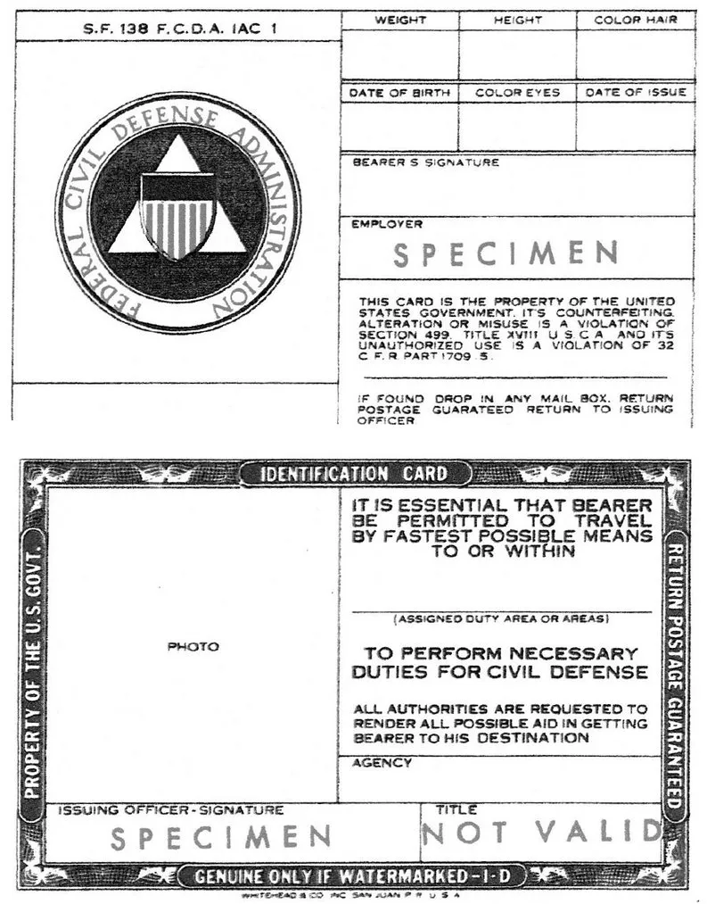
The amount of emergency government planning that went on, and that may still be going on, at Mount Weather was huge. Its computers maintain all sorts of records useful in postwar recovery: medical and educational institutions, military bases, television stations, grain silos, population statistics, communication and transportation networks, and manufacturing centres. A list of mines and caves that could be turned into shelters is also kept on file as possible relocation sites. In his highly revealing article on the facility, ‘The Doomsday Blueprints’, Ted Gup of Time stated that the author of the Federal Register in the 1980s, Martha Girard, was expected to rush to the bunker if the Soviets attacked and continue publishing the document as the Emergency Federal Register.2 She was instructed to keep with her a special identification card that listed her biographical statistics and that declared she was an essential government employee of the federal government, and that she be allowed unrestricted movement. In his article though, Gup claimed Girard did not have much hope for life after doomsday.
Much more planning was put into COG than the above suggests. As in bunkers in other countries, the federal government had pre-recorded audio tapes that would broadcast messages of reassurance to the public. These tapes would have been played over the Emergency Broadcast System, but only upon presidential approval. In the 1950s, the voices used in those recordings were those of President Eisenhower and a well-known celebrity of the time, Arthur Godfrey. In addition to this, selected members of the news media would have been allowed in the bunker during a war to broadcast news to the public. Of course, the newsmen could never reveal anything of the bunker itself since they were sworn to secrecy.
The bunker’s existence was kept from the public for several years until the mid-1970s when a writer learned about it through Senate sub-committee hearings and after conducting discrete interviews. Others caught wind of it after an airliner crashed nearby in 1974. What the writer discovered was that Mount Weather is the nexus to nearly 100 other facilities scattered throughout neighbouring states–most being only hardened office-building basements–and that it acts as the focal point to the entire emergency federal government. The base is so sensitive many hikers who have gotten too close have had their cameras confiscated and when the Russians tried to buy adjacent land for a country estate, the State Department disallowed the purchase. It was never even marked as government property on topographical maps.
Above ground, the Mount Weather complex consists of over two dozen buildings that make up the Emergency Assistance Center. The EAC consists of dormitories and cafeterias that are used by students and guests for law enforcement and disaster management conferences. In 1997, over 23,000 attended various courses and seminars there such as in riot control and rescue planning. Other buildings in the complex include a Veterans Administration-run health centre, fire department, guard house and storage and vehicle depots. At one time, Mount Weather’s fleet of 149 vehicles consisted of buses, maintenance trucks and ambulances. A firearms range is used for practising by law enforcement and security students. The antennae seen on the grounds belong to the agency’s own radio network, the FEMA National Radio System. Rules at Mount Weather are strict and guests are told not to bring in firearms, except for official purposes, pets or cameras; everyone is subject to search. Jogging is prohibited at night and hiking is discouraged because of the presence of poisonous snakes. Gambling and smoking in any building or vehicle are also prohibited.
In addition to COG, Mount Weather’s manager, the Federal Emergency Management Agency, was and is the primary unit responsible for the physical protection of the public. Most of the countries that were threatened during the Second World War had had a civil defence agency in place. After the war, these organizations were either disbanded or held in abeyance, but as the Cold War gathered speed, some began calling for their return. In the United States, the National Security Act of 1947 created the National Security Resources Board as the planning body for civil defence. The lack of immediate threats and the United States’ atomic monopoly, however, caused then-President Truman to deny the Board any real power, so it stuck to planning. But Truman would have a change of heart after the Soviet Union detonated its first atomic bomb and after China fell to the communists in 1949. The President ordered his staff to plan for a new civil defence organization, and in January 1951 the Federal Civil Defense Administration was born. Its director would be a civilian officer who reported directly to the President. Construction soon began on Mount Weather.
Since the 1950s, the FCDA has been renamed so many times it could make one’s head spin. It was known by its first name for only a few years since it was redesignated the Office of Civil and Defense Mobilization in the late 1950s. It was still under civilian control as its chief still reported to the President, although some claim generals and admirals resented having a civilian direct defence activities. This perhaps why the OCDM was later split into the Office of Emergency Preparedness and put under White House control, and the Office of Civil Defense placed under Department of Defense control. The OEP in turn eventually became the Federal Preparedness Agency and the OCD, the Defense Civil Preparedness Agency. In 1979, these two outfits, along with the US Fire Administration, the Federal Disaster Assistance Administration and the Federal Insurance Administration, were consolidated into the present-day FEMA.
Not quite a ‘Get out of jail free’ card, this Federal Civil Defense Administration emergency identification card from the 1950s gave the holder access to areas hit by nuclear weapons or devastated by natural disasters. A large red vehicle marker with the letters ‘CD’ also allowed quick passage. The marker and card were issued to any federal personnel who had civil defence duties, save those from the military services.
After Mount Weather opened in the mid-1950s, President Eisenhower ordered a nation-wide nuclear drill to see how well citizens and the government would respond. The President was spirited to a secret facility in ‘a wooded area’ in Virginia and 15,000 public servants made their way to relocation points. Everyone in a designated target area was ordered to take cover and those that refused, such as pacifists or a salesman in New York City who refused to leave his truck, were arrested. The press was given no hints of the presidential facility’s location other than the fact Eisenhower’s ride took six hours and five minutes from the White House. If Bluemont, which is only 45 miles from the centre of Washington, was indeed this facility, the ride length may have been disinformation.
In addition to geographical and demographical data, FEMA computers keep data on thousands of Americans. In 1960, the point was raised in a top-secret presidential executive memo to the National Security Council that a sufficient number of persons should be kept on file to fill key government posts in times of war should regular staffers be unavailable. Created by Executive Order, the database, known as the National Defense Executive Reserve, is a list of persons from the public and private sectors who would be willing and able to fill positions in the many emergency agencies that would have arisen. The candidates were selected on the basis of their technical or managerial qualifications and accepted only after passing a security screening. But not just anyone could be chosen since applicants were excluded if they served in one of the armed services, if they were elected officials or whether they were already assigned an emergency government function at any level of government.
James Bamford reveals in his book A Pretext for War the names of several of ...
Table of contents
- Dedication
- Title Page
- Copyright Page
- Table of Contents
- Preface
- Acknowledgments
- Glossary
- ❑ AFGHANISTAN
- ❑ ALBANIA
- ❑ AUSTRIA
- ❑ BELARUS
- ❑ BELGIUM
- ❑ BOSNIA
- ❑ BULGARIA
- ❑ BURMA
- ❑ CANADA
- ❑ CHINA
- ❑ CROATIA
- ❑ CUBA
- ❑ CZECH REPUBLIC
- ❑ DENMARK
- ❑ EGYPT
- ❑ ESTONIA
- ❑ FINLAND
- ❑ FRANCE
- ❑ GERMANY
- ❑ GIBRALTAR
- ❑ GREECE
- ❑ HUNGARY
- ❑ INDIA
- ❑ INDONESIA
- ❑ IRAN
- ❑ IRAQ
- ❑ ISRAEL
- ❑ ITALY
- ❑ JAPAN
- ❑ KAZAKHSTAN
- ❑ LATVIA
- ❑ LESOTHO
- ❑ LITHUANIA
- ❑ LIBYA
- ❑ MALAWI
- ❑ MONTENEGRO
- ❑ NETHERLANDS
- ❑ NEW ZEALAND
- ❑ NICARAGUA
- ❑ NORTH KOREA
- ❑ NORWAY
- ❑ PAKISTAN
- ❑ PANAMA
- ❑ POLAND
- ❑ PORTUGAL
- ❑ QATAR
- ❑ ROMANIA
- ❑ RUSSIA
- ❑ SAUDI ARABIA
- ❑ SERBIA
- ❑ SINGAPORE
- ❑ SLOVAKIA
- ❑ SOUTH AFRICA
- ❑ SOUTH KOREA
- ❑ SPAIN
- ❑ SWEDEN
- ❑ SWITZERLAND
- ❑ SYRIA
- ❑ TAIWAN
- ❑ TURKEY
- ❑ UKRAINE
- ❑ UNITED KINGDOM
- ❑ UNITED STATES
- ❑ VIETNAM
- ❑ Notes
- ❑ References
- ❑ Websites Consulted
- ❑ Index
Frequently asked questions
Yes, you can cancel anytime from the Subscription tab in your account settings on the Perlego website. Your subscription will stay active until the end of your current billing period. Learn how to cancel your subscription
No, books cannot be downloaded as external files, such as PDFs, for use outside of Perlego. However, you can download books within the Perlego app for offline reading on mobile or tablet. Learn how to download books offline
Perlego offers two plans: Essential and Complete
- Essential is ideal for learners and professionals who enjoy exploring a wide range of subjects. Access the Essential Library with 800,000+ trusted titles and best-sellers across business, personal growth, and the humanities. Includes unlimited reading time and Standard Read Aloud voice.
- Complete: Perfect for advanced learners and researchers needing full, unrestricted access. Unlock 1.5M+ books across hundreds of subjects, including academic and specialized titles. The Complete Plan also includes advanced features like Premium Read Aloud and Research Assistant.
We are an online textbook subscription service, where you can get access to an entire online library for less than the price of a single book per month. With over 1.5 million books across 990+ topics, we’ve got you covered! Learn about our mission
Look out for the read-aloud symbol on your next book to see if you can listen to it. The read-aloud tool reads text aloud for you, highlighting the text as it is being read. You can pause it, speed it up and slow it down. Learn more about Read Aloud
Yes! You can use the Perlego app on both iOS and Android devices to read anytime, anywhere — even offline. Perfect for commutes or when you’re on the go.
Please note we cannot support devices running on iOS 13 and Android 7 or earlier. Learn more about using the app
Please note we cannot support devices running on iOS 13 and Android 7 or earlier. Learn more about using the app
Yes, you can access Underground Structures of the Cold War by Paul Ozorak in PDF and/or ePUB format. We have over 1.5 million books available in our catalogue for you to explore.