- 256 pages
- English
- ePUB (mobile friendly)
- Available on iOS & Android
eBook - ePub
About this book
K2 is a legend - one of the most demanding mountaineering challenges in the world and one of the most treacherous. Extreme, unpredictable weather and the acutely difficult climbing conditions test the technique, endurance and psychological strength of the most experienced mountaineers to the limit and often beyond. Many of the men and women who have sought to reach the summit have failed, often with tragic consequences - over 70 of them have died or disappeared. Yet this, the second highest mountain on Earth, continues to exercise for the worlds top mountaineers a special, and all too often lethal attraction. Richard Sales fascinating new book traces the climbing history of K2 over the last 150 years, he shows in graphic detail how it acquired this awesome reputation: it was during the first serious attempts on the summit in the 1930s and 1950s that K2 became known as the Savage Mountain.
Trusted by 375,005 students
Access to over 1.5 million titles for a fair monthly price.
Study more efficiently using our study tools.
Information
Chapter 1
The Mountain, The Challenge
‘K2 … just the bare bones of a name, all rock and ice and storm and abyss.’
Fosco Maraini
The Mountain
In 1915 the German meteorologist and geophysicist Alfred Wegener1 published a book entitled Die Enstehung der Kontinente und Ozeane (‘The Origin of Continents and Oceans’), in which he set down his theory that the Earth’s continents had once formed a single supercontinent, which he called Pangaea (from the Greek for ‘all land’), surrounded by a single sea, Panthalassa (‘all water’), and that the break up of Pangaea and the drifting of its fragments over millions of years had formed the land masses we see today. Unfortunately Wegener’s theory included an assessment of how long it had taken for Greenland to separate from Scotland, but his calculations were based on inaccurate data. That, combined with the fact that scientists could not envisage a method for the movement of land masses on a ‘solid’ Earth, meant the theory was dismissed for many years, despite offering an answer to why identical fossils were found in well-separated continents, and why the geology of some continental edges was surprisingly similar. Not until the 1960s did data accumulated by Harry Hess2 finally establish the basis of continental drift, vindicating Wegener’s theory. In general, continents move about 4cm/year, about the same rate at which fingernails grow.
Today it is known that the break-up of Pangaea resulted from the movement of seven major (and a few minor) ‘plates’, rigid sections of the Earth’s crust (the continental land masses) floating on a fluid mantle. As Pangaea broke up, Eurasia rotated towards Gondwanaland (which comprised South America, Africa, India, Australia and Antarctica). Between them was the Tethys Ocean.3 The tectonic plates beneath oceans are denser than those below continents and so sit lower in the Earth’s fluid mantle. As the plates move, oceanic plates therefore slip below (or subduct) continental plates. The process of subduction crumples the surface of the upper, continental, plate, raising mountains. Perhaps the clearest example of this process is the Andean chain of mountains on the western edge of South America, still being formed as the tectonic plate beneath the Pacific Ocean subducts below the South American continental plate. As the Eurasian plate moved towards Gondwanaland, a process that began perhaps 250 million years ago and continued for around 200 million years, subduction of the Tethys plate created a similar chain of peaks, the first Karakoram. The rock from which K2 is built is, primarily, gneiss, a metamorphic rock, i.e. one created by the action of heat and pressure. The K2 gneiss is some 120 million years old,4 the heat and pressure that transformed it from its granite parent rock deriving from the subduction of the Tethys plate in this first phase of the construction of one of the Earth’s great mountain ranges.
About 150 million years ago India and Madagascar separated from Gondwanaland and began to move north. During the Early Cretaceous period the Indian plate rifted away, becoming an island and beginning a rapid northward drift, its speed of travel, at 15-20cm per year, probably setting the record for a tectonic plate. The pace of movement of the Indian plate meant that it closed the gap to the Eurasian plate, which was also moving north, and the Tethys Ocean disappeared as the distance between the continental plates narrowed. Approximately 50 million years ago India collided with the southern margin of the Asian landmass, which itself had been formed by an amalgamation of earlier plate accretions onto the stable Siberian craton (the stable interior of a continental tectonic plate). The India–Asia collision occurred at equatorial latitudes; following the collision and the closing of the Tethys Ocean that lay in between, India has continued its northward drift, ploughing into Asia and forming the Himalaya and the Tibetan plateau in the process.
The collision slowed the northward movement of the Indian plate, but it was (and is still) moving faster than the larger plate, resulting in an upthrust in the collision zone. One effect of the collision is that the area is seismically active: an earthquake close to K2 and Broad Peak in 1983 caused séracs to fall which then initiated avalanches on both peaks. But the seismicity of the area is much less than might be expected, despite the occurrence of the devastating earthquake of October 2005 which caused major destruction in Pakistan-controlled Kashmir to the north of Islamabad, killing an estimated 80,000 people.
The Karakoram is part of the Asian side of this great collision, and is geologically similar to the central part of the Tibetan plateau, but whereas Tibet is high and flat, the Karakoram is deeply incised by glaciers and rivers and contains many major peaks, several of them over 6000m and including four of the fourteen 8000m peaks (K2, Broad Peak, Gasherbrum I and Gasherbrum II). The other major 8000m peak in Pakistan, Nanga Parbat, is actually the western extension of the Indian plate Himalayan range.
The Karakoram stretches for some 450km west–east. To the west the range is often defined by the Karakoram Highway linking Islamabad with Kashgar, but geologists extend the range beyond the highway. Ardito Desio, the leader of the successful 1954 Italian expedition, extended the range to the Yasin valley, considering there was no sharp distinction between the Karakoram and the Hindu Kush, the two ranges merging. Today most geologists consider the junction between the Hindu Kush and the Karakoram is the Rushan Fault (south-east of Tirach Mir), the two ranges lying to either side.
To the east the range is usually defined by the Karakoram Pass (though there are those who argue for a boundary further east, in Ladakh). The pass, at 5540m, 5°30’48”N, 77°49’23”E, is on an ancient trading route between Leh, in Ladakh, and Shache (formerly Yarkand) in China’s Xinjiang Autonomous Region. The pass may also be the point at which China, India and Pakistan meet, the hesitation resulting from the existence of a disputed zone between India and Pakistan which covers an area around the Siachen Glacier. The area from the glacier to the Karakoram Pass was controlled by Pakistan until 1984, when Indian troops took control. Since then there have been spasmodic firefights between soldiers of the two nations (one by-product of which has been the closure of the first ascent route on Gasherbrum I as it lies perilously close to the area of conflict). The maintenance of troops in such a climatically hostile area costs each country an alarming amount of money (some figures suggesting a total bill of up to $15 million daily, though a figure of $2 million or so seems more likely), but as the border dispute is seen in the context of the sovereignty of Kashmir, no clear end is currently in sight.
The pass is the likely source of the range’s name, karakoram meaning ‘black rocks’ or ‘black earth’ in Turkic. However, this derivation is disputed by those who claim the name derives from the Mongolian khara kherem meaning ‘black barrier’, kara/khara being common for black in both Turkic and Mongolian. Even if it is not actually the true source of the range’s name, ‘black barrier’ would be entirely appropriate, the area’s combination of altitude and glaciation making it a barrier to travel and trade.
The height of any mountain range is a complex balance between the rate of uplift due to tectonic processes, the hardness of the rock and surface erosion effects. Though it has only four of the world’s fourteen 8000m peaks, those four – and two other peaks above 7900m – form an arc only 25km in length to the north of the Baltoro Glacier; this arc, one of the great mountain features of the planet, also forms the border between China and Pakistan. The range also includes a further fifteen or so peaks above 7500m. Indeed, the Karakoram is the highest mountain range on the planet. The average altitude for such an incised landscape is hard to calculate accurately, but is considered to be comparable to that of the Tibetan plateau, where satellite GPS measurements indicate an average altitude of 5000m.
One consequence of this extreme altitude is that Karakoram winters are cold, viciously so, the cold and altitude resulting in a large number of glaciers, some of them vast. The longest glacier outside the polar regions is the Fedchenko in the Pamirs, but the Karakoram has the next three longest, the Siachen, Biafo and Baltoro, the range also having more continental glaciers than any other locality outside the polar regions. The combination of altitude and glaciation which impeded ancient traders has also created one of the most spectacular mountain landscapes on Earth. But the nature of the landscape means that the traveller has to work hard in order to admire it. The Himalayan 8000m peaks and Nanga Parbat can be seen by the casual tourist with little or no great effort, and certainly without requiring glacier travel; in the Karakoram glacier travel is essential for any reasonable view of the highest mountains.
Geologically, the Karakoram is highly complex.5 Prior to the India–Asia collision both the Karakoram and southern Tibet formed an Andean-type margin characterised by granite batholiths and extrusive volcanic rocks. During the collision the crust of the Asian plate was thickened by folding and thrusting processes. Crustal thickening increased pressures and temperatures, altering the sedimentary and volcanic rocks to crystalline metamorphic rocks. Most of the southern Karakoram consists of these metamorphic rocks, the Baltoro granite batholith intruding during the Miocene period approximately 23–13 million years ago. These spectacular granites now form most of the impressive towers and spires for which the Karakoram is noted: the Trango Towers, Uli Biaho Tower, Shipton Spire and Masherbrum are all formed of Baltoro granite. Glaciers have incised deep valleys through the granite, the resulting 1000–2000m cliff faces being a direct result of this glaciation.
To the north of the Baltoro granite Broad Peak and the Gasherbrum peaks are largely made up of sedimentary rocks of the Upper Palaeozoic and Mesozoic periods (Carboniferous to Jurassic, including Permian limestone and Carboniferous black shale). Dioritic intrusions also form part of Broad Peak and Gasherbrum IV, the junction between this dark quartzite rock and the paler limestone being clearly seen on the northern, left, side of Gasherbrum IV when viewed from Concordia. K2 is made up of a complex mixture of older pre-collision Andean-type granites that were strongly metamorphosed during the later collision and intruded by numerous leucogranite dykes. To the north of K2, and running along the Tashkurgan valley (Xinjiang) and Nubra valley (Ladakh), the Karakoram fault is a strike-slip fault that divides the rugged geomorphology of the Karakoram from the high-elevation low-relief geomorphology of the Tibetan plateau. There is good geological evidence that both the Karakoram and Tibet were high (possibly as high as the present-day Andes) before the Indian collision 50 million years ago, but have gained height and crustal thickness since that collision.
The Name
Knowing that to maintain dominance and control trade it was necessary to map an area, soon after they took Bengal in eastern India the British began to survey their new holding. The early work was relatively crude, but in 1799 William Lambton6 proposed a more precise survey which began in 1802.7 One outcome of the survey was the discovery that the Himalayan peaks – which lay in Nepal, at that time closed to foreigners, though the peaks could be both seen and surveyed from India – were the highest on Earth. One in particular, a peak given various designations by different surveyors, was the actual highest.8
As British influence in India expanded, so did the survey work. When the British took control of the Punjab they befriended the ruler of Jammu (in part by giving him control over neighbouring Kashmir) and extended the survey to the mountainous region to the north. It was to prove a difficult job, the survey requiring the establishment of base stations at over 20,000ft (6,000m) where snow 11ft (3.5m) deep had to be excavated to reach the bedrock necessary to hold the instruments firmly. As a consequence, the survey took ten years. That it was completed at all is credit to the 25-year-old Royal Engineer captain who was put in charge, Thomas Montgomerie.9
The surveying station from which Montgomerie made his observation of the Karakoram was set up a few days earlier under the direction of another survey officer, William Henry Johnson, and it is likely that Johnson was the first European to see K2. Nevertheless, the honour of naming the peak fell to Montgomerie. Of his first view of the Karakoram Montgomerie wrote,
During my three days residence on the snowy mountain Haramook,10 at upwards of 16,000 feet above sea level, I had several fine views of the Karakoram Range to the north of the Indus. Amongst others, two very fine peaks were visible beyond the general outline of the Muztagh and Karakooram [sic] ranges. These two peaks promise to be high; they were faintly defined against the sky, being probably about 150 miles from me.11
Montgomerie made his observations on 10 and 11 September 1856 and made a sketch of the two peaks in his notebook:
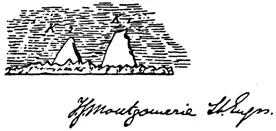
He labelled the larger, double-summitted of the two peaks K1. The smaller, more pointed peak he labelled K2. K3, K4 and K5 stood to the right of the pointed peaks; these were later identified as summits of the Gasherbrum range. In these designations ‘K’ was for Karakoram. Montgomerie could make a bearing on the two peaks, but without a further bearing could not calculate their heights. The second bearing was obtained in 1857 when, during July and August, observations were made from close to Skardu. These allowed Montgomerie to make a preliminary estimate of the height of K2, which he gave as 28,400ft. Further observations in 1858 and 1859 allowed Montgomerie to refine his figure, dropping the height to 28,287ft. He was now able to write that the height ‘will probably not alter much when all the refinements of computations have been applied. The peak may therefore be considered the second highest in the world.’ As to the peak’s name, Montgomerie noted that no ‘reliable name for this gigantic peak’ had been discovered but ‘every endeavour will be made to find a local name it if has one’.
One month before K2 was surveyed, Henry Thuiller, Deputy Surveyor-General of the GTS, announced to a meeting of the Asiatic Society of Bengal that the world’s highest mountain had been discovered. It was to be called Mont Everest, a name chosen by Thuiller’s boss, Andrew Scott Waugh, in honour of the previous Surveyor-General, George Everest. In his letter to Thuiller announcing the discovery and the naming, Waugh had written:
I was taught by my respected chief and predecessor, Colonel Geo. Everest, to assign to every geographical object its true local or national appellation … I have always scrupulously adhered to this rule … But here we have a mountain … without any local name that we can discover, whose native appellation, if it has any, will not very likely be ascertained before we are allowed to penetrate Nepal …12
There is good reason to believe that in suggesting that there was no known name Waugh was, to use the modern parlance, being economical with the truth. His idea that it would need access to Nepal to confirm a native name seems logical, but the mountain is visible from Tibet and the Tibetan name Chomolungma was already known. When Brian Hodgson, a former political officer resident in Kathmandu, suggested that the peak was actually called Devadhunga or Bhairathan, Waugh set up a committee to investigate these and other claims.13 All were dismissed, but crucially no mention seems to have been made of Chomolungma. As a consequence, the name Everest was sanctioned; with occasional grumblings, it has become more or less accepted throughout the world, though the Chinese use a Sino-Tibetan form of Chomolungma.
In the aftermath of Montgomerie’s designation, K1 was found to be called Masherbrum by the villagers of Kaphalu, from where it was visible. But K2 was not visible from any settlement. It is visible from near Paiju, close to the snout of the Baltoro Glacier, but from there it is hardly imposing enough to have warranted a specific name. It is also visible from a small village near Shaksgam, to the north (see Chapter 2). In the apparent absence of a local name an attempt to name the peak after Henry Haversham Godwin-Austen mercifully failed, apparently because of strong Indian representation (Pakistan at the time being part of British India) over the application of the names of members of the rulin...
Table of contents
- Cover
- Title
- Copyright
- Contents
- Acknowledgements
- List of Illustrations
- Introduction
- 1. The Mountain, The Challenge
- 2. Early Explorations
- 3. The Americans Head for K2
- 4. The First Ascent: The Italians, 1954
- 5. The Next Thirty Years
- 6. 1986
- 7. The Next Twenty Years
- 8. 2008
- 9. The Next Step
- Notes
- Appendix 1: K2 Ascent Data
- Appendix 2: Fatalities on K2
- Index
Frequently asked questions
Yes, you can cancel anytime from the Subscription tab in your account settings on the Perlego website. Your subscription will stay active until the end of your current billing period. Learn how to cancel your subscription
No, books cannot be downloaded as external files, such as PDFs, for use outside of Perlego. However, you can download books within the Perlego app for offline reading on mobile or tablet. Learn how to download books offline
Perlego offers two plans: Essential and Complete
- Essential is ideal for learners and professionals who enjoy exploring a wide range of subjects. Access the Essential Library with 800,000+ trusted titles and best-sellers across business, personal growth, and the humanities. Includes unlimited reading time and Standard Read Aloud voice.
- Complete: Perfect for advanced learners and researchers needing full, unrestricted access. Unlock 1.5M+ books across hundreds of subjects, including academic and specialized titles. The Complete Plan also includes advanced features like Premium Read Aloud and Research Assistant.
We are an online textbook subscription service, where you can get access to an entire online library for less than the price of a single book per month. With over 1.5 million books across 990+ topics, we’ve got you covered! Learn about our mission
Look out for the read-aloud symbol on your next book to see if you can listen to it. The read-aloud tool reads text aloud for you, highlighting the text as it is being read. You can pause it, speed it up and slow it down. Learn more about Read Aloud
Yes! You can use the Perlego app on both iOS and Android devices to read anytime, anywhere — even offline. Perfect for commutes or when you’re on the go.
Please note we cannot support devices running on iOS 13 and Android 7 or earlier. Learn more about using the app
Please note we cannot support devices running on iOS 13 and Android 7 or earlier. Learn more about using the app
Yes, you can access The Challenge of K2 by Richard Sale in PDF and/or ePUB format, as well as other popular books in History & Military & Maritime History. We have over 1.5 million books available in our catalogue for you to explore.