- 352 pages
- English
- ePUB (mobile friendly)
- Available on iOS & Android
eBook - ePub
Intelligence Images from the Eastern Front
About this book
Despite the Luftwaffe being ordered to destroy millions of aerial photos in 1945, the Allies found no less than twenty tons of photos in eleven locations, including a hoard in a Bavarian barn. These together with vast numbers of photographs taken by German soldiers used for Intelligence analysis were put into classified Allied Intelligence files at a time when USAAF and RAF imagery was being destroyed. Covering Iron Curtain countries they were valuable for cartography and target intelligence during the Cold War.The captured German imagery (called GX) in this book show what the German Army knew about the Soviet Union before and during Operation Barbarossa. Examples show Eastern Front landforms, key cities such as Stalingrad, Moscow, Sevastopol, Leningrad and factories. They are accompanied by helpful comments from a skilled photo interpreter.This unique and diverse collection, some taken from 28,000 feet overhead, others taken by soldiers on the ground, reveal the war on the Eastern Front as it has never been seen before.
Trusted by 375,005 students
Access to over 1.5 million titles for a fair monthly price.
Study more efficiently using our study tools.
Information
Chapter I
INTRODUCTION
By inclination, Intelligence organizations are peopled by pack-rats. Everything that comes in is kept because it may be of use in the future. That works for a given conflict, but Intelligence is perishable. When the ‘old stuff’ obviously has less (if any) usefulness it is usually stuck in boxes and filed. The bulk of it, and there is a LOT, is sometimes eventually destroyed. Old Intelligence materials are like old buildings. If they survive long enough to be considered ‘historic’ they may be kept. If not they will be removed to make room for newer items.
During World War II, German Intelligence collected a large volume of ground and aerial photos, including those of their invasion of the Soviet Union.
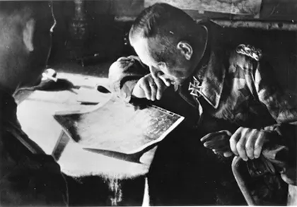
German Photo Interpreters (PIs) were experienced and, evidence shows, quite good.
Many senior German officers regularly relied on aerial imagery.
Some of that material was captured by the Allies at the end of World War II and quickly recognized as a valuable source of Targeting and Cartographic Intelligence for the Cold War.1 Some of the ground shots showed key buildings, construction of bridges, location of factories and rail yards.
Luftwaffe imagery of Russia was the only source of aerial photo coverage prior to the U-2 in 1957 and Corona satellites in the 1960s.
Twenty tons of German photoreconnaissance results and ground photography were found in eleven different locations in Germany. In June 1945 the mother lode, the German Army Print Library, was found in a barn 8 miles south west of Salzburg.2 A few of those boxes of original German contact prints contained paper traces showing where the mission went. That was something we had to know, so the prints were taken to the Aeronautical Chart and Information Center (ACIC) in St Louis, MO and plotted at a scale of 1:250,000. Those plots, made in the Standard Indexing System (SIS), were the retrieval tools for the imagery.
All US aerial imagery flown anywhere in the world was indexed that way.
Still photos were filed and retrieved by content/subject. Some included a ‘Frisket’, a piece of film with date, location and subject that would be printed with the image negative. Others had finding tools that were gone by the time I was involved, making those images unlocatable in a search and findable only at random.
SIS Plots were on 20” x 24” transparencies showing where frames of aerial imagery fell on a map. Normally every fifth frame was shown so a flight trace could be seen. Vertical plots are shown as squares or rectangles. Low Obliques3 are drawn as closed convex polygons. High Obliques always show the horizon so are drawn as open-ended convex polygons.
A Standard Indexing System overlay was made for each camera position with frames falling in each mission in a Degree Square (one degree of Lat x one degree of Long) shown by corner tics on the overlay below. The center line is 30’ of Long.
One recce mission could generate dozens of SIS plots. SIS Plots were filed in large metal-clad binders which were stacked on shelves in wooden boxes specially made to hold them. A busy Degree Square could have more than one SIS Book.
Want to see if someplace had coverage? Go to the Film Library and locate the proper Degree Square plot book. Fold pages back till you got to the date range you wanted and slip the appropriate map underneath. You could see what the imagery covered and decide what you wanted to look at, or have the photo lab copy for you.
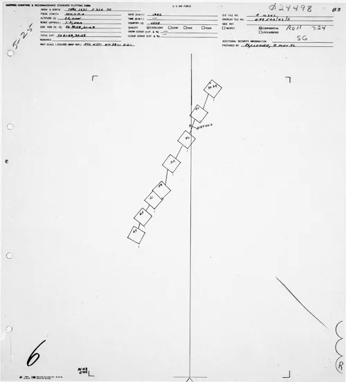
This plot is for a run over Stalingrad (48N44E). The location of Stalingradski Landing Ground is noted. The SIS Plot header (enlarged below) told mission/sortie, date, focal length and altitude (needed to compute imagery scale), exposure range, when the plot was made (in this case May 1956) and by whom.
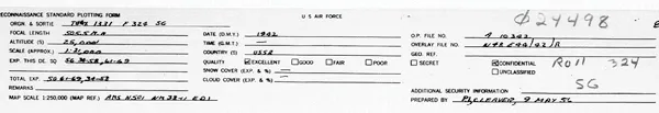
SIS header enlarged.
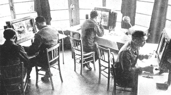
German PIs working off original negatives. Most German roll film was sprocketed and 11.9” wide.4 American lab and PI equipment was designed for 9.5” roll film and we didn’t have German light-tables or lab equipment.
Thus GX could only be viewed using prints or reproductions from copy cameras. Repeated handling would have soon destroyed the prints, so, one frame at a time, to cameras reduced image size and transferred them, US standard copy film—thousands of cans of 500’ rolls of film. For two decades military intelligence and cartographic requirements for coverage of the Soviet Union were serviced by that film. From 1945 to 1957, GX was the only thing we had over some areas. After the U-2 and Corona, GX was still valuable to provide ‘comparative cover’, a way to see what had changed from then to now. Eventually satellites were frequent enough to provide their own comparative cover.
In 1976 I was assigned as Deputy of the Defense Intelligence Agency (DIA) Division with custody of all DoD imagery. By the time I became involved calls, for Luftwaffe coverage were few and far between. I lived what came next and here’s the way I remember it.
When DIA was formed in October 1961 my Division had inherited original roll negatives from Air Force, Army and Navy repositories. Our mission was to retrieve, copy and deliver whole missions or selected exposures to military units needing the images. Film went back to the 1930s, but the bulk was WW II. Our film custody was mostly a paper transfer of Army and Navy material already stored in the General Services Administration Federal Record Center, Suitland, MD.5 More than 100,000 cans of aerial film6 from Southeast Asia ballooned the collection to strain the Records Center and probably +90% of the film we held hadn’t been withdrawn for use in years.
In 1977 GSA asked DIA to reduce cost by culling our holdings. At the same time, silver price was very high and aerial film has a silver halide emulsion that could be recovered. A win-win situation, the brass thought. It was the Carter Administration and cost saving was a fetish, so we were pressured by our hierarchy. Nearly dormant GX film was a prime candidate.
I was concerned. I had degrees in Geography and History and had read everything I could on WW II and knew what could be seen on aerial film, so I was aware of the treasures that might be on those rolls. I was loath to destroy material without knowing what it was. The fact that no one had called for a roll or box of film recently didn’t mean it had no value. By coincidence, one of our researchers had recently withdrawn a roll of old film to satisfy a request from one of the military commands and found it was on highly flammable nitrate base. The National Archives recently had a fire caused by nitrate base film (I think it was old newsreels) so everyone was sensitive to the problem. The boss directed a screening program to physically look at all the older film, searching for more nitrate so those rolls could be converted to safety film. That screening resulted in discovery of numerous rolls of film with obvious historic significance.
I spent time with people from the National Archives Modern Military Branch to create lists of things they’d like to see retained.
I began looking at our computer print-outs for significant locations and almost immediately found Pearl Harbor and Wake Island days before the 1941 attacks, pre-war Philippines, D-Day and other names I recognized. We contacted The National Archives and arranged to move rolls of the most obviously historic imagery from GSA storage to what is now called the National Archives and Records Administration.
In an attempt to convince the head-shed that wanton destruction of unscreened rolls of old imagery to save cost was a bad idea, I made over two hundred 30” x 40” displays using some of the best photos I’d found.
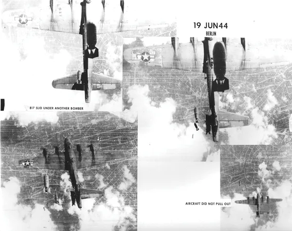
My display board of a USAAF bombing tragedy in Europe.
My displays mounted on the walls of our building attracted much attention.7 Some people in our Division didn’t like what I was doing because they felt it took effort away from our primary mission, but the boss knew what we were finding was good public relations for DIA and DoD. As interest grew, I was ‘unofficially’ helped by other people in the organization who shared my enthusiasm for our nation’s history. Film researchers and photo lab technicians who had experienced WW II first hand kept an eye out for items of special value. Some of them also provided useful information and added ‘corporate memory’ to the investigation. Bless them all for their foresight and wisdom.
Our efforts stalled the push for destruction but didn’t end it. Fortunately the boss, a former Naval Officer and NPIC analyst, agreed with what I was trying to do and was a formidable bureaucrat who knew how to keep our ‘brass’ wolves at bay.8
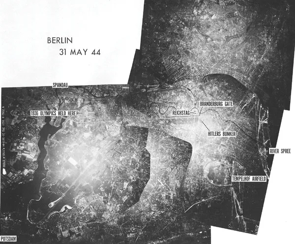
I made a mosaic of Berlin using five exposures.
Displays like these began to get attention and helped show value of the imagery.
I next learned of over a thousand boxes of cut negatives. Most were copies of attachments from briefings, Attaché Reports, photos from foreign sources (mostly British) and captured documents. Most were 4” x 5” or 8” x 10”.
Military Intelligence has an insatiable need to collect photos and documents on the off-chance that something will be meaningful when put with some other piece as yet to be collected, or for some future operation. As war loomed in Europe in the late 1930s, actual collection methods and opportunities were limited so military attachés, agents and librarians in military offices of all the future belligerents were furiously cutting items from newspapers and books, gathering post cards and photos, taking trips and covertly snapping pictures of things that might be important (bridges, RR Stations, air landing fields, military garrisons, factories) in territories they expected might soon be denied to them. Our pre-war aerial photo coverage of foreign soil was almost non-existent.
It was important to learn where things were in other countries, what they were and what they looked like—military installations, industry, transportation, equipment, you name it. Well into the 1940s, Military Intelligence in the United States, with the exception of spies and intercepting, decoding/deciphering message traffic, was essentially a library function, filing away anything that came to hand for use by staff officers from other branches. Except for actual spies, Intelligence was barely a career. In the US, experts, when required, would be called in from industry and aerial photography was mainly for cartography, not intelligence.
People we would recognize today as analysts or intelligence professionals were few and far between in America until well into WW II. Intelligence analysis, such as it was (except for signals intelligence), was done by ‘operators’. Pilots, ship drivers Naval and Army planners, infantry officers, and their civilian counterparts, did their own research and analysis. The same Intel amateurs were assigned to various embassies as attachés collecting most of the information in the field. In fact, well into the 1950s US military personnel considered an assignment in Intelligence was a ‘career killer’.
If an office in the War Department or Navy Department had a problem; a plan needed shaping or updating, a VIP was going on a trip, or a threat assessment was wanted, the action officer went to the appropriate Intel library and pawed through the files for anything of use.
Here is how the system worked for images. Ev...
Table of contents
- Cover
- Title
- Copyright
- CONTENTS
- ACKNOWLEDGEMENTS
- DEDICATION
- FOREWORD
- CHAPTER I INTRODUCTION
- CHAPTER II PREPARING FOR INVASION
- CHAPTER III INVASION 1941
- CHAPTER IV NORTHERN SEAS
- CHAPTER V SCHWARZMEER
- CHAPTER VI 1942
- CHAPTER VII STALINGRAD
- CHAPTER VIII 1943 AND ON
- OBSERVATIONS
- ADDENDUM
Frequently asked questions
Yes, you can cancel anytime from the Subscription tab in your account settings on the Perlego website. Your subscription will stay active until the end of your current billing period. Learn how to cancel your subscription
No, books cannot be downloaded as external files, such as PDFs, for use outside of Perlego. However, you can download books within the Perlego app for offline reading on mobile or tablet. Learn how to download books offline
We are an online textbook subscription service, where you can get access to an entire online library for less than the price of a single book per month. With over 1.5 million books across 990+ topics, we’ve got you covered! Learn about our mission
Look out for the read-aloud symbol on your next book to see if you can listen to it. The read-aloud tool reads text aloud for you, highlighting the text as it is being read. You can pause it, speed it up and slow it down. Learn more about Read Aloud
Yes! You can use the Perlego app on both iOS and Android devices to read anytime, anywhere — even offline. Perfect for commutes or when you’re on the go.
Please note we cannot support devices running on iOS 13 and Android 7 or earlier. Learn more about using the app
Please note we cannot support devices running on iOS 13 and Android 7 or earlier. Learn more about using the app
Yes, you can access Intelligence Images from the Eastern Front by Roy M. Stanley in PDF and/or ePUB format, as well as other popular books in History & Military & Maritime History. We have over 1.5 million books available in our catalogue for you to explore.