- 160 pages
- English
- ePUB (mobile friendly)
- Available on iOS & Android
eBook - ePub
About this book
The Battle of Naseby was the decisive engagement of the English Civil War and the battlefield is the first to have been radically reinterpreted in the light of metal detector research. This guide, co-authored by the principal authorities on the battle, links contemporary accounts to their findings in the context of today's landscape. The book also offers the chance to develop alternative personal interpretations while visiting the key viewpoints and walking the few paths currently accessible to the public.
Trusted by 375,005 students
Access to over 1.5 million titles for a fair monthly price.
Study more efficiently using our study tools.
Information
CONTENTS
Introduction and Acknowledgements
Chapter 1Early 1645 – the war, the armies and the terrain
Chapter 2To Fight or not to Fight – 1 May to 13 June 1645
Chapter 3The Approach to Battle – 14 June 1645
Chapter 4The Battle, 14 June 1645 – the Formal Phase
Chapter 5The Battle, 14 June 1645 – the Fighting Retreat
Chapter 6Exploring the Ground
Map of shot fall
Further reading
Museums and Societies
Index
LIST OF MAPS
Detail from Speed’s map of Northamptonshire, 1610.
River systems of Northamptonshire.
Lea’s revision with roads, of Saxton’s map of Northamptonshire, c. 1680.
Speed’s plan of Northampton, 1610.
Detail, Daventry to Northampton, from Speed, 1610.
Detail, northwest of Northampton, from Eyre, 1779.
Detail, Guilsborough/Naseby/Market Harborough, from Ordnance Survey map, 1908.
Detail, Shepshoks Field, from Naseby Parish map, 1630.
Naseby Parish map, 1630.
Naseby Enclosure map, 1820.
Field names in north of Naseby Parish.
Streeter’s depiction of the armies at Naseby.
De Gomme’s plan of the armies at Naseby.
Detail, the Parliamentary train, from Streeter.
Field names south and west of Naseby.
Marston Trussell Enclosure map, 1815.
Battlefield tour map.
Viewpoints and walk, Sibbertoft/Clipston parish boundary.
INTRODUCTION AND ACKNOWLEDGEMENTS
Producing a Battleground Europe volume on events of the seventeenth century is rather different from covering more recent wars. The documentary evidence is sparse and official military reports in the modern sense are lacking entirely. Those reports of the Civil War in England that do exist are essentially letters written as may please the writer at the time. They lack formal structure, make no attempt to be objective, are vague as to timing and neglect narrative sequence. Some, of course, are better than others, but their use involves creative reconstruction by the historian and thus affords considerable room for alternative interpretation and wishful thinking.
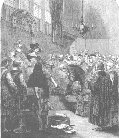
An image of an autocratic king; Charles I holds court. He ruled for many years without summoning Parliament and was suspected of Roman Catholic sympathies.
Maps were rare at the time and are yet rarer today. In the case of Naseby one pre-war map survives, that of the parish as it was in 1630. Road maps did not exist, but Saxton and Speed had made county maps that showed hills and bridges and roads began to appear on maps in the next forty years, so there is some contemporary evidence of where men might have marched and wagons been driven.
The countryside today bears no resemblance at all to the Northamptonshire of 1645, save for the hills. The rivers of the time have been tamed by the creation of canals and their water supply arrangements, and the land alongside them is largely drained by systems installed since then. Modern roads, much though we may grumble about them, bear little relation to the highways of the seventeenth century other than the routes they follow. The first attempt since Roman times to establish state control for long-distance travel was made with an Act of 1555. It was ineffectual. The first turnpike roads were set up after the war. Most of the travellers went on foot; people, cattle and geese alike. A few travelled on horseback. Yet fewer journeyed by bone-shaking cart or coach which was miserably uncomfortable in fine weather and hellish in the wet. Finally, the landscape itself was vastly different. In the area with which we are concerned in this book few villages had been enclosed and the medieval open fields were still the norm, so that, with the exception of the Royal Forests of Whittlewood, Salcey and Rockingham to the south and east of the Naseby campaign territory, the country was open, treeless and without hedges save at parish boundaries. It is also worth remembering that the western flank of Rockingham Forest was marked by the Northampton to Market Harborough road and that the Whittlewood Forest spread across the land between the River Ouse in the south and the River Tove on the approach to Northampton, areas largely absent from the story that follows, but confining the action to the territory discussed here.
So, there are few writings, fewer maps and the whole place looks different. In the circumstances we had better explain how we came to set down what follows, for it may seem curious that we dare say anything at all!
This book is founded in the terrain. Two of the authors were born and grew up in the principal parishes involved. They have both taken an interest in the battle since their boyhood and have more recently spent day after day examining the ground with their metal detectors thanks to the kind permission granted by neighbourly landowners. In addition they have walked, and the third member of the group, the scribe, has walked with them over all the key locations, again by permission of tolerant farmers who look kindly on their curious behaviour. It is with the mapping of finds of shot, coins and equipment and the appreciation of the landscape itself that the work begins.
Second, what written evidence there is has been examined carefully in the light of the landscape research. The few first-hand reports, the immediately proximate secondary accounts and the relatively close histories, within a survivor’s lifetime, have been studied closely, as have training manuals of the time. To that has been added the examination of the work of noted military historians. This has all been tested against the empirical evidence of the ground and its contents.
The result is anything but certainty. Pulling together the facts, reports and opinions leads to an arguably persuasive account of events, but it is not a truth. Alternatives are possible and readers will find in the book, we trust, all the material required to build them in contradiction to what we offer. Further, new finds are possible and ideas may be readjusted at some future time.
The Battle of Naseby dealt a fatal blow to the Royalist cause in the First Civil War and can reasonably be ranked with just two other battles on English soil, Hastings and Bosworth, as the great, pivotal fights in British history. That its location should be so poorly known and the sequence of events in the landscape so difficult to discover is a situation demanding correction. One of the earliest researchers of the battlefield was Edward Fitzgerald, whose family had land here at the enclosure of 1820, including Cloister, Mill and Lodge Hills, the area of the Parliamentarian lines at the start of the battle. He carried out a lively correspondence with Thomas Carlyle who wrote to him on 18 September 1842, saying:
‘Few spots of ground in all the world are memorabler to an Englishman. We could still very well stand a good little book on Naseby!’
And again on 10 October:
‘There ought to be a correct, complete, and every way right and authentic Essay, or little Book, written about Naseby as it now is and as it then seems to have been – with the utmost possible distinctness, succinctness, energy, accuracy and available talent of every sort: I leave you to consider, whether the actual Owner and Heaven’s-Steward of Naseby ought to have no hand in that!’
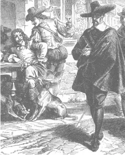
The stereotype of fun-loving Cavaliers (Royalists) versus grim Puritans (Parliamentarians) is excessively simplified. Both sides were internally divided by religious and political difference.
Fitzgerald failed to rise to the bait. Carlyle lays down a challenge to which few, if any, are equal. This volume is, at best, another step along the way and its authors deny any claim to the virtues rehearsed by Carlyle, although two of them could rank as among actual owners but might jib at being classed as Heaven’s-Stewards!
The book begins with a brief summary of the developing situation in the months preceding the battle and, because few readers can be expected to be familiar with the weapons and mode of warfare of the time, a short description is given of them. In order to avoid cluttering up the text with travel data, the next four chapters of the book give a narrative account closely related to the landscape. The landscape itself, then and today, is illustrated with maps and photographs. Troop positions and movements shown are, of necessity, only approximate. Finally, chapter six follows the same sequence with detailed travelling advice presented in such as way as to allow readers to plan their own routes on their own maps to suit their own needs. At the time of writing the battlefield has no facilities for visitors and few public footpaths, but this book should enable people to enjoy a rewarding and exciting visit none the less and, should access improve in the future, some of the views now only available in the photographs will be accessible by all. That the entire battlefield should be open to visitors is a circumstance much to be desired and for which the authors are working. In the meantime this is the best we can offer.
In addition to the books referred to in the text and listed in the references section, material has been reproduced by courtesy of the Bodleian Library, Oxford, the Suffolk County Council, the Northampto...
Table of contents
- Cover
- Half Title
- Full Title
- Copyright
- Contents
Frequently asked questions
Yes, you can cancel anytime from the Subscription tab in your account settings on the Perlego website. Your subscription will stay active until the end of your current billing period. Learn how to cancel your subscription
No, books cannot be downloaded as external files, such as PDFs, for use outside of Perlego. However, you can download books within the Perlego app for offline reading on mobile or tablet. Learn how to download books offline
Perlego offers two plans: Essential and Complete
- Essential is ideal for learners and professionals who enjoy exploring a wide range of subjects. Access the Essential Library with 800,000+ trusted titles and best-sellers across business, personal growth, and the humanities. Includes unlimited reading time and Standard Read Aloud voice.
- Complete: Perfect for advanced learners and researchers needing full, unrestricted access. Unlock 1.5M+ books across hundreds of subjects, including academic and specialized titles. The Complete Plan also includes advanced features like Premium Read Aloud and Research Assistant.
We are an online textbook subscription service, where you can get access to an entire online library for less than the price of a single book per month. With over 1.5 million books across 990+ topics, we’ve got you covered! Learn about our mission
Look out for the read-aloud symbol on your next book to see if you can listen to it. The read-aloud tool reads text aloud for you, highlighting the text as it is being read. You can pause it, speed it up and slow it down. Learn more about Read Aloud
Yes! You can use the Perlego app on both iOS and Android devices to read anytime, anywhere — even offline. Perfect for commutes or when you’re on the go.
Please note we cannot support devices running on iOS 13 and Android 7 or earlier. Learn more about using the app
Please note we cannot support devices running on iOS 13 and Android 7 or earlier. Learn more about using the app
Yes, you can access Naseby by Martin Marix Evans,Peter Burton,Michael Westaway in PDF and/or ePUB format, as well as other popular books in History & Early Modern History. We have over 1.5 million books available in our catalogue for you to explore.