"Written by the greatest living Egyptologist, this wonderful, fun, and short book will take you inside the heads of the ancient Egyptians."—Sarah Parcak,
National Geographic
Egyptian culture is divided from us by several millennia, a lost people and a dead language. We can discover much about this fascinating civilization from its physical remains, but perhaps the greatest insights into the Egyptian mind come from Egyptian hieroglyphs. They reveal the priorities, concerns and beliefs of the Egyptians—a whole worldview. Unlike the Western alphabet, which is an arbitrary set of symbols not anchored in reality, each Egyptian hieroglyph denotes a concept central to Egyptian thinking. The language and its written form are intimately bound up with the imaginative world of the Egyptians.
Here, Barry Kemp presents 100 of the Egyptian hieroglyphs to provide access to this unique culture. Kemp takes us on a journey through the Egyptian mind, revealing not only aspects of day-to-day life in Ancient Egypt, but gradually building a picture of the historical and mythological references that were the cornerstones of Egyptian thought. This fascinating book helps us get inside a long-vanished world.
"A capsule key to the ancient Egyptian mind."—Dr. Norman Hammond,
The Times
"Kemp uses 100 hieroglyphs as a springboard for discussion of a range of topics . . . This clever premise works well . . . [an] enjoyable and informative volume."—
Times Higher Education Supplement
"This is most certainly a book that will challenge and reward."—
New World
Trusted by 375,005 students
Access to over 1.5 million titles for a fair monthly price.
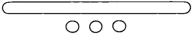
The heart of Egypt was and still is the floodplain of the river Nile, a narrow ribbon of green stretched across a continent-wide desert. No more than 20 kilometres across in the valley proper, it reaches its greatest breadth of 200 kilometres as it fans out into a delta to join the Mediterranean coast in the north. Although the floodplain possesses subtle gradients left by slow meandering swings of the river from side to side, the valley floor gives an overall impression of a flat land, of dark and rather heavy soil. For the word ‘earth’ or ‘land’,
t3 (ta), the Egyptians chose a flat, narrow sign. Beneath it, three small circles were often added, the sign for granules; land was the grainy soil beneath their feet, a physical reality, not a political entity (see no. 3, ‘Grain of sand’).
The borders of modern Egypt run to the Red Sea to the east; to the west and south they make a right angle and cut into the desert. The ancient Egyptian world was far smaller – no more than the muddy floor of the valley north of Aswan. The huge tracts of desert did not belong. A common name that the ancient Egyptians used for their homeland, in reference to its soil colour, was Kmt (Kemet), ‘the black land’. In stepping from the valley to the desert, from the ‘black’ to the ‘red’, the ancient Egyptians were already leaving their country. In their mythology, the ram-headed creator-god Khnum fashioned human beings from clay on a potter’s wheel; Egyptians associated themselves with the mud of their soil, not the sand of the desert.
Even allowing for wide margins of error in our calculations, at the time the pyramids were built the inhabitants of the whole of Egypt would have fitted into one of the larger suburbs of modern Cairo. Compared to today, the people and their dwellings would have been far less obtrusive. The basis of their lives was tilling the rich soil, and the whole population, from the peasant in his tiny house to the king in his sprawling painted palace, lived in buildings whose walls, floors and ceilings were made from mud. We know from their writings that the ancient Egyptians intended to be remembered through buildings of stone which would endure ‘for millions of years’; but these were tombs and temples, not places for the living.
The valley and the delta were treated as separate ‘lands’ in their own right. The Egyptians constructed a myth that, at a time in the distant past, each ‘land’ had been a discrete kingdom, with its own symbols, including a distinctive crown. Each had its own name, and the modern convention is to translate these as Upper and Lower Egypt, for the south and the north, respectively. The kingdom of Egypt was always ‘the two lands’
or more simply
t3wy (tawy), and each king was ‘lord of the two lands’
nb t3wy (neb tawy). The coronation of a new king was a ceremony symbolically re-unifying the two lands. A design of two plants knotted together, found on the walls of temples and palaces, represented the binding of the two kingdoms. Over the kings reigned the supreme god, Amun-Ra, ‘lord of the thrones of the two lands’.
Today the delta, the north, is the more prosperous part of Egypt, and those who live there and who are naturally more exposed to the cultures of the Mediterranean and of the lands to the north-east tend to see the people who live south of Cairo as rough and provincial. It may not always have been so. For the first half of its ancient history, between approximately 3000 and 1300 BC, the ruling families of kings came from the south. Their main city, Thebes, served as the ceremonial centre for the whole country. During the third main historical era (the New Kingdom) it was here that kings were buried (in the Valley of Kings), even when, during the later years, they were men from the north. Thebes was not, though, the equivalent of a modern capital. The main royal residence, Memphis, where government was centred, remained in the north, closer to the delta. One ancient source described it as ‘“the balance of the two lands” in which Upper and Lower Egypt had been weighed’.
2. DESERT
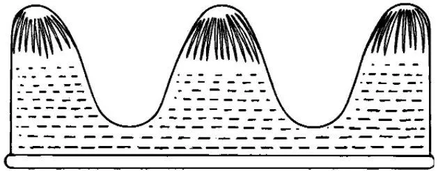
The desert for most Egyptians was a crust of coarse sand and pebbles over horizontal layers of limestone or sandstone. Only those who ventured far to the west – to the area of the Kharga oasis – would have seen the desert of our popular imagination, a sea of sand dunes. Over huge areas, especially to the east of the Nile, the flow from torrential rains has cut the desert surface into networks of valleys, often with precipitous sides: they are nowadays named after the word ‘wadi’, originally an Arabic term, meaning a valley, that is dry except in the rainy season. Further still to the east much harder rocks rise up into jagged hills and low mountains that extend to the Red Sea.
The hieroglyph for desert depicts a broken landscape, with three rounded hills separated by deep valleys. It was added as a determinative sign to words for distant places beyond the Egyptian borders, such as ‘east’ and ‘west’, and for ‘valley’ and ‘cemetery’ – cemeteries often lay on the desert margin (see no. 36, ‘Cemetery’).
The word
(khaset) denoted desert, hill country and foreign land, all at once. In time it took on an ominous quality, especially when applied to the lands to the north-east. These were home to rulers whose ambitions matched those of Egyptian kings and who, from time to time, saw Egypt as an enticing target for their own conquests. In the 17th century BC, the ‘rulers of foreign lands’, from a homeland in Palestine, became the ‘foreign rulers’ of Egypt. This line of kings, called the Hyksos, ruled for two centuries until challenged by a revolt started at Thebes, which had been reduced to a minor-state capital with its own line of kings. Under King Kamose the revolt became a civil war, eventually resulting in the expulsion of the hated ‘Asiatics’, as the foreign rulers and their people were also called. This event marked the beginning of the New Kingdom.
In another Egyptian defeat around 525 BC, towards the end of Egyptian civilization, the Persian King Cambyses took control of the country. He was described as ‘the great prince of all the foreign lands’ by one of his leading Egyptian collaborators, a priest named Udjahor-resenet, who realized that only by transferring his loyalty would his temple and its traditional cults survive and prosper. Udjahor-resenet served for a time, perhaps as a physician, in the Persian court in the land of Elam (probably in the city of Susa), in the part of the Mesopotamian plain that lies in modern Iran. His plan succeeded. He returned to Egypt with a commission to re-endow the centre of learning (which the Egyptians called the ‘House of Life’, see no. 82, ‘Scribal kit’), attached to his beloved temple.
The mindset of Egyptians was strongly influenced by the hostile, mountainous, foreign lands that surrounded them. It was a duty of kings to conquer threatening enemies, who were named in lists on the outside walls of temples. To the title of each enemy land was added the ‘desert’ hieroglyph, even if they were not desert places. These included places in Syria, Babylonia (which was flat and fertile and too far from Egypt to be conquered) and Crete (which was mountainous and was also never conquered by Egypt). In their claims to conquest the lists contained an element of wishful thinking.
3. GRAIN (OF SAND)
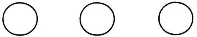
The hieroglyph for ‘land’ is often accompanied by the sign for a grain, a tiny circle. This is either repeated three times
or shown once with three small vertical strokes added
to indicate that there are normally many. Signs of this kind, examples of determinatives, are added to the basically phonetic hieroglyphs that spelled nouns and verbs, in order to point to a broader family to which an individual word belongs. From signs of this kind we can learn how Egyptians grouped and classified their world, even though they appear not to have given much conscious thought to systems of classification.
‘Land’ is granular, as is ‘sand’ when found in the desert and in the riverbank (though not ‘mud’ which takes a different determinative,
linking it to irrigation canals). Equally granular is ‘salt’, wh...
Table of contents
Cover
Title Page
ACKNOWLEDGEMENTS
CONTENTS
TIMELINE
Maps
INTRODUCTION
1. LAND
2. DESERT
3. GRAIN (OF SAND)
4. LIFE
5. SUN
6. HORIZON
7. ‘TO APPEAR’
8. WATER
9. FIELD/COUNTRYSIDE
10. PAPYRUS COLUMN
11. LOTUS
12. TREE
13. PROVINCE
14. STELA (STANDING BLOCK OR SLAB OF STONE)
15. PLOUGH
16. SICKLE
17. GRAIN PILE
18. BEER JUG
19. BULL
20. PIG
21. SETH-ANIMAL
22. RED
23. SPARROW
24. GOOD
25. SERPENT
26. HOUSE
27. DOOR
28. MAT
29. CAT
30. FIRE
31. WICK
32. CITY
33. WALL
34. MOUND
35. WEST
36. CEMETERY
37. PYRAMID
38. MUMMY
39. JACKAL
40. ROAD
41. DONKEY
42. CHARIOT
43. BOAT, TRAVELLING UPSTREAM
44. SAIL
45. SACRED BARQUE
46. SKY
47. OTHERWORLD (DUAT)
48. STAR
49. YEAR
50. MOON
51. ETERNITY
52. PRIMAEVAL TIME
53. SPIRIT
54 King
55. CARTOUCHE
56. PALACE
57. TO UNITE
58. TRUTH (MAAT)
59. TO BE STABLE
60. TO FOLLOW
61. ENEMY
62. BOW
63. MAN AND WOMAN
64. RAZOR
65. UNGUENT
66. TO LOVE
67. SISTRUM
68. BABOON
69. TO HEAR
70. MOUTH
71. BODY
72. PUSTULE
73. KA
74. BA
75. HEART
76. TO BE BORN
77. TO COME INTO EXISTENCE
78. CHILD
79. OLD MAN
80. OFFICIAL
81. SCEPTRE OF POWER
82. SCRIBAL KIT
83. CYLINDER SEAL
84. PAPYRUS ROLL
85. SOLDIER
86. CRAFTSMAN
87. GOLD
88. BRONZE
89. POTTER’S KILN
90. BALANCE
91. CLOTH
92. TO BE PURE
93. TO BE DIVINE
94. SACRED
95. FESTIVAL
96. STATUE
97. WONDER
98. OFFERING PLACE
99. PROTECTION
100. WEDJAT (EYE OF WELLBEING)
NOTE ON SOURCES
INDEX
A, B, C
D, E, F
G, H, I
J, K, L
M, N, O
P, Q, R
S, T, U
V, W, X
Y, Z
About the Author
Copyright
Frequently asked questions
Yes, you can cancel anytime from the Subscription tab in your account settings on the Perlego website. Your subscription will stay active until the end of your current billing period. Learn how to cancel your subscription
No, books cannot be downloaded as external files, such as PDFs, for use outside of Perlego. However, you can download books within the Perlego app for offline reading on mobile or tablet. Learn how to download books offline
Perlego offers two plans: Essential and Complete
Essential is ideal for learners and professionals who enjoy exploring a wide range of subjects. Access the Essential Library with 800,000+ trusted titles and best-sellers across business, personal growth, and the humanities. Includes unlimited reading time and Standard Read Aloud voice.
Complete: Perfect for advanced learners and researchers needing full, unrestricted access. Unlock 1.5M+ books across hundreds of subjects, including academic and specialized titles. The Complete Plan also includes advanced features like Premium Read Aloud and Research Assistant.
Both plans are available with monthly, semester, or annual billing cycles.
We are an online textbook subscription service, where you can get access to an entire online library for less than the price of a single book per month. With over 1.5 million books across 990+ topics, we’ve got you covered! Learn about our mission
Look out for the read-aloud symbol on your next book to see if you can listen to it. The read-aloud tool reads text aloud for you, highlighting the text as it is being read. You can pause it, speed it up and slow it down. Learn more about Read Aloud
Yes! You can use the Perlego app on both iOS and Android devices to read anytime, anywhere — even offline. Perfect for commutes or when you’re on the go. Please note we cannot support devices running on iOS 13 and Android 7 or earlier. Learn more about using the app
Yes, you can access 100 Hieroglyphs by Barry Kemp in PDF and/or ePUB format, as well as other popular books in History & Ancient Languages. We have over 1.5 million books available in our catalogue for you to explore.