The intersection of two disciplines and technologies which have become mature academic research topics in the 1990s was destined to be a dynamic area for collaboration and publication. However, until now no significant book-length treatment of the meeting of GIS and Virtual Reality has been available. This volume puts that situation to rights by bringing these together to cement some common understanding and principles in a potentially highly promising area for technological collaboration and cross-fertilisation. The result is a volume which ranges in subject matter from studies of a Virtual GIS Room to Spatial Agents, and from an Environmental Multimedia System to Computer-Assisted 3D Geographic Education. All the contributors are well-known international scientists, principally from the computational side of GIS. It will be a valuable resource for any GIS researcher or professional looking to understand the leading edge of this fertile field.
- 184 pages
- English
- ePUB (mobile friendly)
- Available on iOS & Android
eBook - ePub
Spatial Multimedia and Virtual Reality
About this book
Trusted by 375,005 students
Access to over 1.5 million titles for a fair monthly price.
Study more efficiently using our study tools.
Information
Subtopic
Digital MediaSpatial Multimedia
Chapter One
Multimedia GIS: concepts, cognitive aspects and applications in an urban environment
Ralf Bill, Doris Dransch and Carmen Voigt
Institute for Geodesy and Geoinformatics, University of Rostock, D 18051 Rostock, Germany
Institute for Geodesy and Geoinformatics, University of Rostock, D 18051 Rostock, Germany
1.1 CONCEPTS
The term 'multimedia', it seems, is on everyone's lips. In Germany, multimedia was the word of the year in 1995. Multimedia is an irreversible trend in computing. Nevertheless, multimedia comes with a range of completely different meanings: convergence of different worlds, such as telephone, computer and television; products such as videoconferencing, interactive TV and on-line services; or the integration of different media, such as text, graphics and video for information presentation. Multimedia enhances the overall quality and quantity of information. Most areas of information technology are embracing the emerging multimedia platforms, data types and environments. Multimedia may be seen as a concept that includes the technical as well as the application-oriented dimension of media integration. In the context of GIS, multimedia systems can be applied as information and monitoring systems, as learning systems or for co-operative work.
A multimedia system may be characterised as a computer-based system for integrated processing, storage, presentation, communication, creation and manipulation of independent information from multiple time-dependent and time-independent media (translated from Steinmetz et al., 1990).
The major keywords in this definition are independent, integrated, time-dependent and time-independent. Each of these media should be treated independent of the others. They are integrated with the aid of computers and software, which should be able to synchronize the various sources according to spatial, temporal and content-specific relations. Integration of multimedia in a user's environment means that the user is not only viewing multimedia information but also creating and authoring multimedia objects. Time-independent media are text, graphics, tables, images and others. Time-dependent media are video and audio sequences, and sound. These media serve as information types in a multimedia system.
The idea of multimedia systems is a fairly old one, but the progress of hardware and software technology has brought this idea alive. Multimedia is extending in two major ways. On the one hand, multimedia systems are making use of the architecture and semantics of today's commercially available hypertext products. On the other hand, additional hardware such as video discs and real-time data compression boards are allowing the inclusion of time-dependent media, which were not part of hypertext systems.
Combining the above given definition of multimedia with a definition on GIS (Bill, 1994; Bill and Fritsch, 1994) leads to the following term:
A multimedia GIS may be characterized as a computer-based system consisting of hardware, software, data and applications allowing for integrated digital capture and editing, storing and organizing, modelling and analysing, presenting and visualizing spatially referenced data of multiple time-dependent and time-independent media.
The first GIS products with multimedia extensions are on the market. Craglia and Raper (1995) name two different approaches, which nowadays have to be extended to give a third approach:
- 'GIS in Multimedia', integrating further data types and spatial analysis functionality in proprietary multimedia authoring tools, such as Toolbook, Macromedia Director and Authorware.
- 'Multimedia in GIS', increasing the multimedia handling capabilities of existing GIS packages, such as Maplnfo, ArcView and WinCAT.
- 'World Wide Web plus GIS extensions', making use of the WWW functionality and its ability to integrate other types of software (e.g. Map Objects Internet Map Server, ArcView Internet Map Server, CGI scripts and Java applets)
Currently, no standard method exists for multimedia GIS implementations;. With further standardization activities, such as Open GIS consortium, Open Doc and Windows functionalities (Object Linking and Embedding OLE 2.0, Component Object Model (COM) and Common Object Request Broker Architecture CORBA), new methods for implementation are appearing.
For a multimedia GIS, it is important to decide which media may support a specific task and how to make use of this in a daily computer environment. Current GIS technology mainly deals with time-independent media such as text, vector and raster graphics, and tables. The questions are as follows:
- Which time-dependent media are to be foreseen in a GIS?
- How can these media be combined with the existing time-independent media?
To answer this, investigations in the applications field as well as in human cognition are required (see chapter 2).
A major feature of a GIS is its analytical capability—an area in which many questions arise with respect to these new media:
- What type of analysis functionality is needed for new media such as images, video and audio, and what is the practical usage in a GIS environment?
- Which operations are suitable and meaningful for the new media?
An easy way to realize multimedia components is to integrate video or animation sequences of a planned situation in a GIS. A video sequence of the surrounds of a planned situation could help to decide a better planning alternative. A generated animation of a certain scenario, for instance, in environmental applications, may be helpful in answering 'What happens if?' questions.
Some specialized GIS deal with certain aspects of multimedia systems. For instance, in car navigation systems, time-dependent media such as a Global Positioning System (GPS) and an Inertial Navigation System (INS) are merged with selected spatial data on traffic routes and road signs in vector or raster format. Thus, position computation and route-finding can be combined with additional static or dynamic traffic information, such as traffic light sequences and vehicle volumes at a specific road segment. A further example of integrating time-dependent media in GIS is the TV inspection of sewerage systems, where the video-camera movement is georeferenced to the linear duct segment.
An interesting application for video may be an image sequence analysis—one that follows a spatially related object and derives a trajectory of its movement. Pure visualization techniques may also be useful, especially if they are context-sensitive. With the help of new media, the abstract view in GIS may become more realistic. The overlay of existing or planned information with video sequences may be one of the techniques used here. GIS will participate in the field of virtual reality.
1.2 COGNITIVE ASPECTS
In a multimedia GIS, it is necessary to decide which medium may support a specific task. To answer this, application fields as well as human cognition and function of media in the visualization process have to be considered. The application of media in different working fields has already been discussed (Cassettari et al., 1993; Fonseca et al., 1993, 1995a,b; Polydorides et al., 1993; Blat et al., 1995; Kerekgyarto et al., 1995; Raper et al., 1995; Câmara, 1997; Shiffer, 1997). In this contribution we want to point out cognitive aspects which are significant in a multimedia GIS.
Media in GIS have to show information about spatial objects and their relations, about spatial processes, and about planned situations and calculated scenarios. Multimedia techniques offer the whole palette of different media to present this information for investigation as well as for demonstration. The greater the palette of possible media, the more important it is to make the right choice. The following aspects can serve as guidelines for applying different media in a GIS.
The first aspect is the purpose that the medium has to fulfil. Should it give a vivid picture of an object or should it help to create a complex mental model from objects and their relationships? Cognition science (Weidenmann, 1991; Dreher, Mack 1996) distinguishes four types of functions that media may have:
- the function of demonstration
- the function of putting into context
- the function of construction
- the function of motivation
Each of these functions can be performed best by a specific type of medium.
1.2.1 The function of demonstration
Media for demonstration should help the user to get a suitable 'picture', a correct and complete idea of a phenomenon. Pictures, videos, realistic graphic representations and animations, as well as virtual reality, are best suited for this task. They can show the individual characteristics of an object. In the field of the urban environment, for instance, animations of planned buildings or of historical situations can improve the imagination and influence decision-making. Pictures of important or extraordinary buildings enclosed within a city map support peoples' navigation through the town. Also, audio can be applied in the above-mentioned way to present the sound of an individual place. For example, audio gives a vivid expression about the sound and loudness of a planned road with or without noise protection (see Figure 1.1). In particular, people who do not have a great knowledge of the topic need demonstration media.
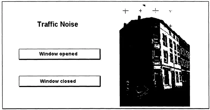
Figure 1.1 Traffic noise.
1.2.2 The function of construction
Media with the function of construction should help the user to create complex mental models. Mental models are constructions of knowledge about single information units and relationships. Media for this purpose have to inform about elements, their relations and co-operation. Pictures or realistic presentations are not suitable in this context. On the contrary, this function requires abstract media with prepared information such as maps, diagrams, graphs or formal sound. The creation of these models is highly influenced by the applied media. Graphs and diagrams should be used to present information on quantitative and qualitative relations, such as the structure of a population. Maps are to be applied to show spatial relationships. Dynamic presentations, such as animations, are capable of showing spatial processes such as the growth of a city. For example, creating a mental model of daily traffic flow in a city works best with a map or an animation of maps that show the traffic's spatial and temporal distribution. Videos and pictures can illustrate the phenomenon, but they can hardly create the mental model. Media for construction are to be applied in a GIS especially when analysing and exploring spatial data.
1....
Table of contents
- Cover
- Half Title
- Title Page
- Copyright Page
- Contents
- Preface
- Series introduction
- List of contributors
- I. SPATIAL MULTIMEDIA
- II. VIRTUAL REALITY
- Index
Frequently asked questions
Yes, you can cancel anytime from the Subscription tab in your account settings on the Perlego website. Your subscription will stay active until the end of your current billing period. Learn how to cancel your subscription
No, books cannot be downloaded as external files, such as PDFs, for use outside of Perlego. However, you can download books within the Perlego app for offline reading on mobile or tablet. Learn how to download books offline
Perlego offers two plans: Essential and Complete
- Essential is ideal for learners and professionals who enjoy exploring a wide range of subjects. Access the Essential Library with 800,000+ trusted titles and best-sellers across business, personal growth, and the humanities. Includes unlimited reading time and Standard Read Aloud voice.
- Complete: Perfect for advanced learners and researchers needing full, unrestricted access. Unlock 1.5M+ books across hundreds of subjects, including academic and specialized titles. The Complete Plan also includes advanced features like Premium Read Aloud and Research Assistant.
We are an online textbook subscription service, where you can get access to an entire online library for less than the price of a single book per month. With over 1.5 million books across 990+ topics, we’ve got you covered! Learn about our mission
Look out for the read-aloud symbol on your next book to see if you can listen to it. The read-aloud tool reads text aloud for you, highlighting the text as it is being read. You can pause it, speed it up and slow it down. Learn more about Read Aloud
Yes! You can use the Perlego app on both iOS and Android devices to read anytime, anywhere — even offline. Perfect for commutes or when you’re on the go.
Please note we cannot support devices running on iOS 13 and Android 7 or earlier. Learn more about using the app
Please note we cannot support devices running on iOS 13 and Android 7 or earlier. Learn more about using the app
Yes, you can access Spatial Multimedia and Virtual Reality by Antonio S. Camara,Jonathan Raper in PDF and/or ePUB format, as well as other popular books in Technology & Engineering & Digital Media. We have over 1.5 million books available in our catalogue for you to explore.