With its apparently complete town plan, revealed by the Society of Antiquaries of London's great excavation project, 1890-1909, Silchester is one of the best known towns in Roman Britain and the Roman world more widely. Since the 1970s excavations by the author and the University of Reading on several sites including the amphitheater, the defenses, the forum basilica, the public baths, a temple, and an extensive area of an entire insula, as well as surveys of the suburbs and immediate hinterland, have radically increased our knowledge of the town and its development over time from its origins to its abandonment. This research has discovered the late Iron Age oppidum and allowed us to characterize the nature of the settlement with its strong Gallic connections and widespread political and trading links across southern Britain, to Gaul and to southern Europe and the Mediterranean. Following a review of the evidence for the impact of the Roman conquest of A.D. 43/44, the settlement's transformation into a planned Roman city is traced, and its association with the Emperor Nero is explored. With the re-building in masonry of the great forum basilica in the early second century, the city reached the peak of its physical development. Defense building, first in earthwork, then in stone in the later third century are major landmarks of the third century, but the town can be shown to have continued to flourish, certainly up to the early fifth century and the end of the Roman administration of Britain. The enigma of the Silchester ogham stone is explored and the story of the town and its transformation to village is taken up to the fourteenth century. Modern archaeological methods have allowed us to explore a number of themes demonstrating change over time, notably the built and natural environments of the town, the diet, dress, health, leisure activities, living conditions, occupations, and ritual behavior of the inhabitants, and the role of the town as communications center, economic hub and administrative center of the tribal 'county' of the Atrebates.
- 240 pages
- English
- ePUB (mobile friendly)
- Available on iOS & Android
eBook - ePub
About this book
Trusted by 375,005 students
Access to over 1.5 million titles for a fair monthly price.
Study more efficiently using our study tools.
Information
Subtopic
British HistoryIndex
Social SciencesCHAPTER ONE
Discovering Calleva
The most significant development in the history of investigations into the Iron Age and Roman town at Silchester was the great, 20-year long, project by the Society of Antiquaries of London to reveal what, at the time, was thought to be the complete plan of the town within its defensive walls. The excavations took place between 1890 and 1909, providing the first glimpse of the entirety of a Roman town in Britain and indeed of any town within the Roman world, even celebrated Pompeii. The town was confirmed to have been divided into regular insulae (Latin = islands), the great majority containing a number of buildings ranging from well-decorated private houses to modest shop or workshop premises, a few also with a temple or possible temple, one with a possible church, and the whole protected by the massive town wall. A few blocks were dominated by the public buildings they contained: the great forum basilica at the centre, dominating the town; the public baths at the lowest point of the town by the springs in the south-east quarter; the trio of temples in their enclosure by the east gate; and the inn with its attached bath house by the South Gate. The influence of the main thoroughfare, the east–west street which carried traffic between London and the west of Britain, can easily be seen in the crowding together, side-by-side, of narrow-fronted shops-cum-workshops competing for business along its length (Figs 1.1–2).
As we will see, there is a background of cumulative discoveries to this revelatory work, but it was a combination of factors which determined that Silchester was the first Roman town to be explored in this way. First and foremost it was a greenfield site only impinged upon by the parish church of St Mary the Virgin and the farm and farm buildings on its eastern side, but it was also in the single ownership of a sympathetic landowner, the Duke of Wellington, and the influential antiquarian society, the Society of Antiquaries of London, was keen to sponsor excavation. With large open areas within their walls, other Roman town sites offered similar potential: Aldborough of the Brigantes in Yorkshire, Caistor St Edmunds of the Iceni in Norfolk, Verulamium of the Catuvellauni beside St Albans in Hertfordshire and Wroxeter of the Cornovii, in Shropshire (Fig. 1.3). Across the River Severn in south-east Wales was the site of Caerwent, the chief town of the Silures, which, though the Roman town was partly buried beneath the village which had developed over it, followed Silchester to be the second most explored town of Roman Britain. Most of the other greenfield Roman towns saw substantial area excavations in the first half of the 20th century, but with none revealing more than parts of their whole town plan. Despite its shortcomings, as we shall see, the ‘complete’ plan of Roman Silchester has been published repeatedly through the 20th and into the present century and, as a consequence, arguably still remains the best-known Roman town in Britain. The background to the decision in 1890 to excavate Silchester can now be explored.

FIGURE 1.1 Aerial view of Silchester taken in 1976 looking towards the east, showing part of the Iron Age defences, the Roman street grid and outlines of some of the buildings (courtesy Chris Stanley)
Despite being shrouded in trees and vegetation, the impressive remains of its circuit of town walls, a mile and a half in length and enclosing a little over 100 acres (40+ hectares), had attracted antiquarians’ interest in Silchester since the 16th century. Among them was William Stukeley who visited Silchester in 1724 and, while recognising the amphitheatre for what it is, mistakenly depicted the town in the form of a rectangular military fort with its characteristic ‘playing card’ plan (Fig. 1.4). Although the outline of streets, which became visible each summer as the crop ripened, had been commented on by Camden in his great survey, Britannia, first published in English in 1610, it was the surveyor John Wright who was the first to attempt a systematic record of these and the town walls in 1745 (Fig. 1.5).

FIGURE 1.2 The plan of Calleva after the completion of excavations by the Society of Antiquaries within the town walls in 1908

FIGURE 1.3 Map of Britain showing the locations of the major Roman towns
Various accounts record digging taking place within the walls in the 18th and 19th centuries but with little information as to what was found. It was not until 1864 that excavations took place which were of a more scientific character, being recorded in some detail and eventually published in summary form. This was the work of the Reverend James Joyce, the rector of Stratfield Saye, who was encouraged by the second Duke of Wellington to undertake excavations, the manor of Silchester having been acquired by the first Duke in 1828. Joyce left two beautifully illustrated bound notebooks and a sketchbook, now in Reading Museum, full of information about the individual buildings and structures that his workmen had uncovered as well as about his methods of excavation (Fig. 1.6). While his work mainly laid bare the ground plans of the structures he found, it is clear that he also appreciated the importance of stratigraphy and how that could help him understand change over time and how to date buildings from independently dated objects, such as coins, associated with them. We see this, for example, in his interpretation of one of his most important discoveries, the forum basilica, the central building of the Roman town, which is understood to have accommodated administrative and judicial functions. Although Joyce and his team of four workmen excavated in several parts of the town within the walls, it is his work on the town gates, the forum basilica, the houses in Insula I and XXIII and the temple in Insula VII which are the most important, not least because they were published. His outstanding single find is undoubtedly the fine bronze ‘Silchester’ eagle which, along with other objects, was displayed in Stratfield Saye House, home of the Duke of Wellington (Figs 1.7, 3.18). These included a complete mosaic floor and fragments of two others which were lifted and re-laid in the entrance hall (Figs 1.8, 7.5). Excavation continued in a desultory way after his death, aged only 59, in 1878, including with the discovery of the large building and bath house near the South Gate which is very probably the mansio of the town. This was the accommodation reserved for officials and other users of the imperial posting service (cursus publicus).

FIGURE 1.4 William Stukeley’s illustration of the amphitheatre in 1724

FIGURE 1.5 John Wright’s plan of the town in 1745

FIGURE 1.6 Page dated 17 October 1870 from Joyce’s diary illustrating the fine copper alloy mount or handle known as the ‘Silchester horse’
(© READING MUSEUM (READING BOROUGH COUNCIL). ALL RIGHTS RESERVED)
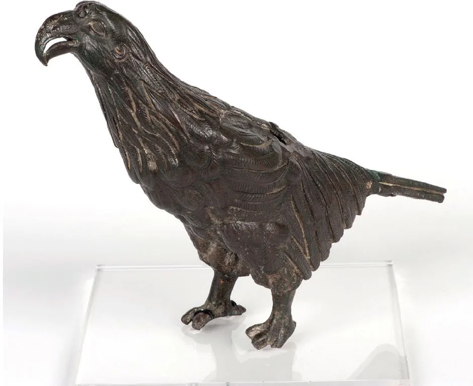
FIGURE 1.7 The Silchester Eagle discovered by Joyce’s workmen in 1866. Made in bronze, it probably dates from the 1st century AD. It may have formed part of a statue of Jupiter or an imperial person, the eagle at the foot of the figure looking up
(PHOTO BY IAN CARTWRIGHT, © READING MUSEUM (READING BOROUGH COUNCIL). ALL RIGHTS RESERVED)
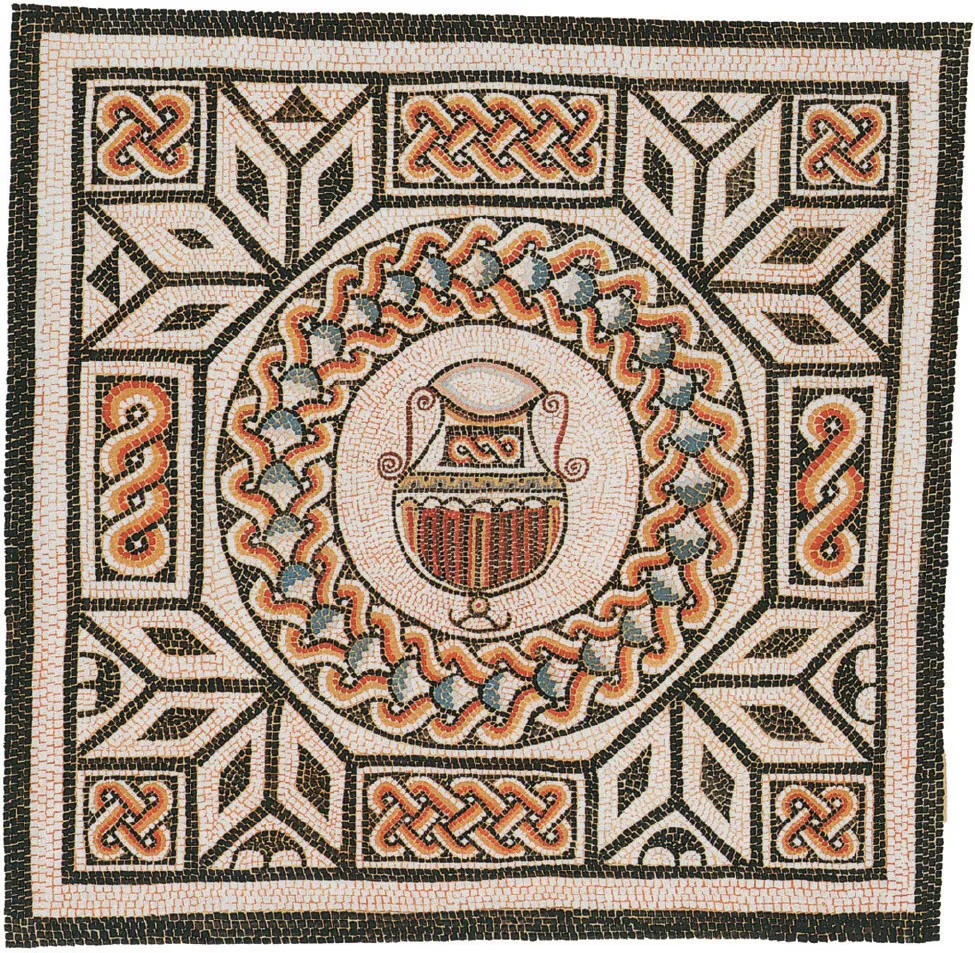
FIGURE 1.8 Second century mosaic from Insula I, House 1 discovered in 1864 and re-laid in the front hall of Stratfield Saye House
(PAINTING BY STEPHEN COSH, COURTESY OF STEPHEN COSH AND DAVID NEAL AND BY PERMISSION OF THE SOCIETY OF ANTIQUARIES)
Uncovering the town
It was Joyce’s work which drew the attention of General Pitt Rivers, the first Government Inspector of Ancient Monuments, and the Society of Antiquaries of London to the remains at Silchester and the potential they had for revealing, for the first time, a complete plan of a Roman town. With the agreement of the third Duke of Wellington, a project began in 1890 sponsored by the Society of Antiquaries which was to last 20 years and was to reveal what was thought at the time to be the complete plan of the town within the walls. The excavation was directed by W. H. St John Hope, a senior official of the Society, and George E. Fox, an artist-architect and student of Roman Britain. Wherever possible the area was dug insula by insula with individual buildings identified by parallel narrow trenches dug systematically and diagonally across each one (Fig. 1.9). The insulae were individually numbered, the total amounting to 37 (Fig. 1.2). As wall foundations were discovered, they were followed to define the individual buildings which were then excavated to floor level (Fig. 1.10). The trenches were sounded for soft spots which might conceal the tops of pits or wells, which, on excavation, often turned out to contain well preserved artefacts, including items of organic materials such as the wooden barrels used to line the wells (Fig. 1.11), and two great hoards of ironwork, as well as very many examples of complete pots. There was methodological innovation, too, most notably by the geologist, Clement Reid, who, with his assistant, A. H. Lyell, recovered waterlogged seeds and insects from pits and wells each year from 1899 onwards. Reid identified a range of horticultural crops introduced by the Romans and grown in Britain, as well as traded items from the Mediterranean such as figs and grapes or raisins, though the latter could eventually have been grown locally.

FIGURE 1.9 Antiquarian excavation techniques: Left: plan of trenching across the north-east of Insula IX in 1893; right: geophysics detects traces of the Society of Antiquaries’ trial trenching across the whole town 1890–1908 (adapted from Creighton with Fry 2016, fig. 3.8)
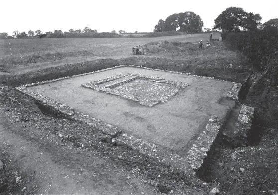
FIGURE 1.10 The temple in Insula XXXV excavated by the Society of Antiquaries in 1907. The spoil heaps from Joyce’s excavation of the forum basilica can be seen in the background
(©READING MUSEUM (READING BOROUGH COUNCIL). ALL RIGHTS RESERVED))
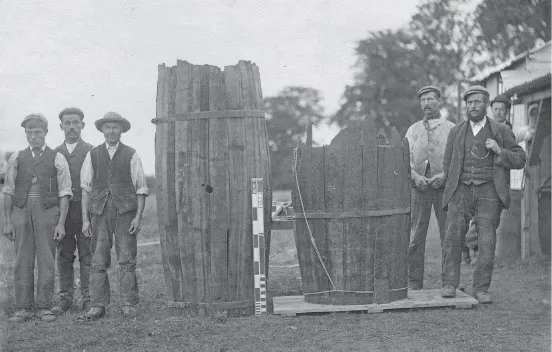
FIGURE 1.11 Imported wine-barrels of silver fir, subsequently re-used to line wells. Note the workmen and the scale.
(© READING MUSEUM (READING BOROUGH COUNCIL). ALL RIGHTS RESERVED)
The year’s work was reported in the Society’s journal Archaeologia and included both overall plans of each insula and more detailed plans and descriptions of individual buildings and a summary of the more notable finds. Excavation within the walls was completed in 1908 and a final season of work took place the following year on the outlying earthworks and some Roman pottery kilns accidentally discovered to the north of the town. No excavation was undertaken on the amphitheatre and no attempt was made to locate extramural cemeteries. Over the years there had been much speculation as to the Roman name of the town, but this was brought to an end by the discovery in 1907 in a temple in Insula XXXV of an inscription carved on Purbeck marble recording a dedication by a guild (collegium) of foreigners (peregrini) confirming that the town was indeed Calleva, an identification first mooted in the early 18th century (Fig. 1.12).
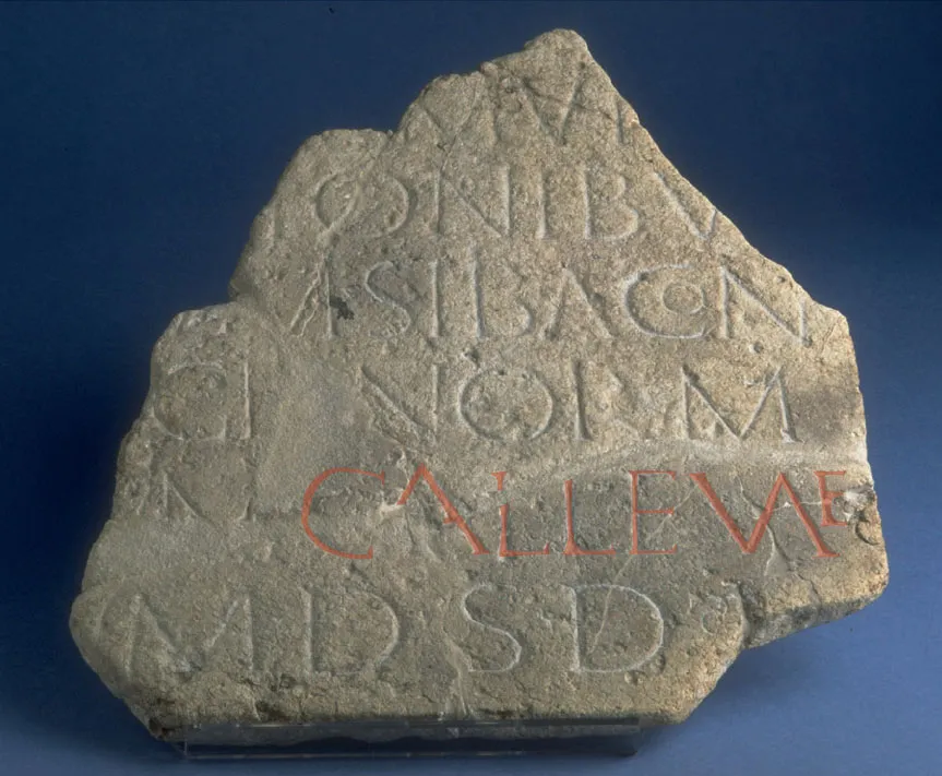
FIGURE 1.12 Inscription carved in Purbeck Marble found in 1907 associated with the temple in Insula XXXV. It records a dedication which provides confirmation that Calleva was the ancient name of Silchester: CALLEVAE can be read in the penultimate line from the bottom
(© READING MUSEUM (READING BOROUGH COUNCIL). ALL RIGHTS RESERVED)
The excavations recovered a large number of finds, but by no means all were kept, particularly those of animal bone, building materials, whether of stone or brick, and pottery sherds, all of which were found in very large numbers (Fig. 1.13). Attention focused on rare finds, such as of sculptured fragments or inscriptions, and on metalwork, mostly of copper alloy, including coins, which are the most numerous find in this metal, but also well preserved ironwork. Complete or ...
Table of contents
- Cover
- Title
- Copyright
- Contents
- List of figures
- Acknowledgements
- Preface
- 1 Discovering Calleva
- 2 Beginnings: the late Iron Age Royal Centre of Calleva
- 3 Caratacus, the Roman conquest, Nero and Calleva
- 4 From town to city: Calleva, a regional centre
- 5 The 2nd century: Calleva at its peak
- 6 Calleva defended
- 7 Late Roman Calleva
- 8 Living in late Roman Calleva
- 9 The end
- Postscript
- Further information and reading
Frequently asked questions
Yes, you can cancel anytime from the Subscription tab in your account settings on the Perlego website. Your subscription will stay active until the end of your current billing period. Learn how to cancel your subscription
No, books cannot be downloaded as external files, such as PDFs, for use outside of Perlego. However, you can download books within the Perlego app for offline reading on mobile or tablet. Learn how to download books offline
Perlego offers two plans: Essential and Complete
- Essential is ideal for learners and professionals who enjoy exploring a wide range of subjects. Access the Essential Library with 800,000+ trusted titles and best-sellers across business, personal growth, and the humanities. Includes unlimited reading time and Standard Read Aloud voice.
- Complete: Perfect for advanced learners and researchers needing full, unrestricted access. Unlock 1.5M+ books across hundreds of subjects, including academic and specialized titles. The Complete Plan also includes advanced features like Premium Read Aloud and Research Assistant.
We are an online textbook subscription service, where you can get access to an entire online library for less than the price of a single book per month. With over 1.5 million books across 990+ topics, we’ve got you covered! Learn about our mission
Look out for the read-aloud symbol on your next book to see if you can listen to it. The read-aloud tool reads text aloud for you, highlighting the text as it is being read. You can pause it, speed it up and slow it down. Learn more about Read Aloud
Yes! You can use the Perlego app on both iOS and Android devices to read anytime, anywhere — even offline. Perfect for commutes or when you’re on the go.
Please note we cannot support devices running on iOS 13 and Android 7 or earlier. Learn more about using the app
Please note we cannot support devices running on iOS 13 and Android 7 or earlier. Learn more about using the app
Yes, you can access Silchester Revealed by Michael Fulford in PDF and/or ePUB format, as well as other popular books in Social Sciences & British History. We have over 1.5 million books available in our catalogue for you to explore.