Originally published in 1983, this book sets the phases and elements of Glasgow's townscape evolution in their historical framework, from the medieval period when Glasgow was a small but important burgh to the growth of the town thanks to its command of the transatlantic tobacco trade in the 18th Century. Examining the solid growth which came with the textile phase of the industrial revolution and subsequent pioneering achievements in ship-building and marine engineering, the book also charts the subsequent collapse of the industrial base and attempts at urban renewal on a massive scale.
- 212 pages
- English
- ePUB (mobile friendly)
- Available on iOS & Android
eBook - ePub
About this book
Trusted by 375,005 students
Access to over 1.5 million titles for a fair monthly price.
Study more efficiently using our study tools.
Information
1. ENVIRONMENT AND URBAN ROOTS
In the historical geography of a city, deep tap-roots may draw their sustenance from the environment of its site and setting, as well as from the pre-urban activities of human beings, and consideration of these influences provides a framework within and upon which, later development may be examined. In the case of Glasgow, attention naturally focuses upon the River Clyde, as barrier, routeway and provider at the local scale, and as the unifying element and core of a wider hinterland. Two contrasting facets of its lower valley strongly influenced the early development of the city. From Lanark downstream to a point where the Molendinar Burn joins the Clyde (Fig. 2.i) the freshwater river is relatively narrow, and could be crossed by ford or bridge at numerous points. Immediately downstream of the Molendinar confluence, a ford lies next to what was for many centuries the lowest bridging point on the river, and the upper limit of tidal reach. Below Glasgow bridge, the salt waters of the Clyde broaden into an estuary giving access to a suite of long, deep sea-lochs which penetrate the mainland of Argyllshire. These two facets symbolise the background to Glasgow’s early growth, as the market centre for an agricultural hinterland, and as the head of navigation of a western area of fishing and sea-borne trade. On its course to the sea, the Clyde flows across a range of rock types and rock structures which provided the city with sandstone for building, coal for domestic and industrial fuel, and iron ore for its foundries, while confluent streams flow to their junctions across glacial till and through drumlin swarms whose surfaces supported agriculture and provided dry settlement sites for early man. At all scales, a wide range of natural assets awaited the exploiting mind and hand of man, allowing him to lay the cultural foundations upon which a great city might arise.
Geology and geomorphology
The Clyde Valley is itself a facet of the western portion of the great Midland Valley of Scotland, and it embodies many of the features of geology and geomorphology common to its parent. Lying between the Highland and Southern Uplands Boundary Faults, the Midland Valley is an extensive down-faulted rift, whose floor of Old Red Sandstone is overlain by sedimentary rocks of the Carboniferous series, broken in places by igneous extrusions. The Carboniferous rocks differ in their stratigraphic sequence from those of England and Wales1, with oil-shales and cementstones making up for the absence of thick Limestone strata. The important coalbearing strata, however, are well represented in the Coal Measures and the Carboniferous Limestone Series. At the base of the sequence, the rocks of the Calciferous Sandstone Series in the Glasgow region lack the economically useful oil-shales characteristic of their eastern extensions, but above them the rich organic fossils of the Limestone Coal Group of the Carboniferous Limestone Series more than compensate for this deficiency, with blackband ironstone high enough in carbonaceous contact to permit smelting without charcoal or coal2. Above all, their coal seams, relics of the swampy environment whose Lepidodendroids are preserved in the Fossil Grove in the west of Glasgow at Whiteinch3, yielded a rich return to miners. The succeeding Millstone Grit, while devoid of fossil fuels, embodies seams of refractory fireclay, of sufficient thickness and extent to be of considerable economic value.
At the top of the sequence lie the Coal Measures, whose surface Barren Red Measures give way to the lower Productive Measures, up to 400 metres in thickness, with numerous workable seams. Though the effects of local faulting often made exploitation difficult, the character of the coal made it worthwhile. The greater part of the deposits was bituminous, with 80-90% carbon content, with some localised metamorphic anthracite in the vicinity of igneous intrusions. The igneous rocks of the Carboniferous Series complete the geological picture, with their exposed volcanic vents and resistant lava flows providing the high ground which almost encircles the site of Glasgow to the north, south and west, thus producing the major differentiation of topography within the western sector of the Midland Valley. Smaller scale topographic features, some of localised, and others of wider significance, owe their origin and form to the effects of glaciation.
The geological skeleton was clothed by the deposits of the Devensian glaciation, during which ice from the Highlands, reaching the Glasgow region by way of the Gareloch, Loch Lomond and the Strathblane Gap, first blocked the flow of the Clyde to the sea, forming a large pro-glacial lake, 30 metres deep, in the Clyde Basin. Sands, silts, gravels and clays were deposited on the bed of this lake, to be moulded by the eastward-advancing ice into drumlins, numerous on both sides of the river. The melting ice of deglaciation swelled post-glacial seas, permitting marine transgression c.13,000 B.P.4 with the formation of deposits of silts and clays of considerable lateral extent within the basin. Isostatic readjustment elevated these to around eight metres O.D., providing a series of gently-sloping low-lying surfaces. Between these raised marine terraces, backed by their drumlin swarms, the Clyde flowed west, through the gap between the lava plateaus, to empty into its broad estuary, itself giving access to a suite of long, deep sea-lochs, extending their fingers into the south-west Highlands.
On a smaller scale, the landforms which most dramatically characterise the local topography are undoubtedly the drumlins. The present built-up area of the city covers over 180 of these whalebacks5 (Fig. 1.i), some two-thirds of which lie north of the river, and the remainder to the south. Their higher, steeper faces are aligned roughly north west, with the gentler slopes of the tails pointing south-east, echoing the direction of glacial advance through the valley. They display wide variation, both in areal extent and in height from base to crest, with over 50% being more than ten metres in height, and a significant number from 25-30 metres, with one north-western outlier reaching 37 metres. In their original form, the drumlins must have been even larger, since an estimated four to five metres of till has been removed from their surfaces by periglacial mass movement6. The uneven hilly land surface which they produce has had significant effects on the alignment of roads and railways, which largely avoid crossing them, and often make detours following the valleys between them7, while from Victorian times onwards, numerous sections of the built-up area have been contoured around their slopes.
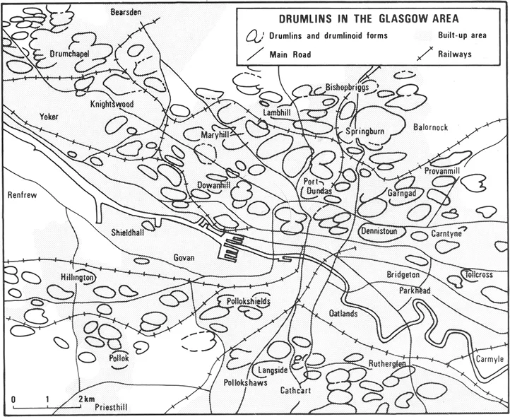
1.i Drumlins in the Glasgow area
The development of Glasgow took place within a rich and varied geological and geomorphological framework, affording a range of possibilities to its inhabitants at different technological stages. In medieval times, the fording point on the Clyde, the possibilities of fishing locally and further afield, and farming on the heavy clay soils developed on the glacial till provided both a natural focus for trade, and the commodities to support the growth of a burgh and its market. Fast-flowing streams and abundant soft water within the region gave power and progress to the early textile phase of the Industrial Revolution, while the local coal and iron ores provided fuel and raw materials for its subsequent phases, which saw the structures of the city march north, south, east and west along the alluvial terraces and over the drumlins.
Early man in Glasgow: prehistoric to early Norman
From the early Post-Glacial period onwards, access via routeways from the Forth and Tweed valleys in the east and south-east, Ayrshire and the Solway Lowlands in the south-west, and along the broad highway of the River Clyde itself, gave a nodality to the basin of the Lower Clyde and attracted human settlement. The low-lying, sheltered basin, with its mild, moist climate, would have been thickly wooded in prehistoric times, and the marshy lowland flats or haughlands along the river would have provided a rich source of food for early hunter-gatherers, although the incursion of the Post-Glacial sea removed probable sites of Mesolithic activity.
Neolithic farmers and Bronze Age metallurgists left numerou...
Table of contents
- Cover
- Half Title
- Title Page
- Copyright Page
- Original Title Page
- Original Copyright Page
- Table of Contents
- Dedication
- List of figures
- List of plates
- List of tables
- Glossary and periodical abbreviations
- Acknowledgements
- Preface
- 1. Environment and Urban Roots
- 2. The Medieval Town: 1175-1560
- 3. Reformation to Act of Union — the Growth of a Mercantile Burgh: 1560-1707
- 4. New Horizons: America and the Tobacco Trade: 1707-1775
- 5. The Age of Cotton: 1776-1841
- 6. Iron in the Soul: 1841-1914
- 7. Brave New World — The Planned City: 1918-1982
- Epilogue
- Index
Frequently asked questions
Yes, you can cancel anytime from the Subscription tab in your account settings on the Perlego website. Your subscription will stay active until the end of your current billing period. Learn how to cancel your subscription
No, books cannot be downloaded as external files, such as PDFs, for use outside of Perlego. However, you can download books within the Perlego app for offline reading on mobile or tablet. Learn how to download books offline
Perlego offers two plans: Essential and Complete
- Essential is ideal for learners and professionals who enjoy exploring a wide range of subjects. Access the Essential Library with 800,000+ trusted titles and best-sellers across business, personal growth, and the humanities. Includes unlimited reading time and Standard Read Aloud voice.
- Complete: Perfect for advanced learners and researchers needing full, unrestricted access. Unlock 1.5M+ books across hundreds of subjects, including academic and specialized titles. The Complete Plan also includes advanced features like Premium Read Aloud and Research Assistant.
We are an online textbook subscription service, where you can get access to an entire online library for less than the price of a single book per month. With over 1.5 million books across 990+ topics, we’ve got you covered! Learn about our mission
Look out for the read-aloud symbol on your next book to see if you can listen to it. The read-aloud tool reads text aloud for you, highlighting the text as it is being read. You can pause it, speed it up and slow it down. Learn more about Read Aloud
Yes! You can use the Perlego app on both iOS and Android devices to read anytime, anywhere — even offline. Perfect for commutes or when you’re on the go.
Please note we cannot support devices running on iOS 13 and Android 7 or earlier. Learn more about using the app
Please note we cannot support devices running on iOS 13 and Android 7 or earlier. Learn more about using the app
Yes, you can access Glasgow by Andrew Gibb in PDF and/or ePUB format, as well as other popular books in Social Sciences & Geography. We have over 1.5 million books available in our catalogue for you to explore.