Lakes and Empires in Macedonian History: Contesting the Waters tells the story of Psarades, a lakeside village in Macedonian Greece on the shores of the Prespa lake. This village, which is in many ways a completely typical Greek settlement and yet remains unconventional in its way of life, embodies the many contradictions of modern history and in exploring its roots James Pettifer and Miranda Vickers skilfully uncover the wider social, cultural and political history of this lake region.
Drawing from oral testimonies and attentive to the construction of national histories, this book considers how the development of international borders, movement of people and role of national identities within imperial borderlands shaped Macedonia today. What is more, by centering the lakes and making use of an innovative environmental historical methodology, Pettifer and Vickers offer the first environmental history of this multi-ethnic borderland region shared by Greece, North Macedonia and Albania. The result is a nuanced and sophisticated transnational account of Macedonia from prehistory to the 21st century which will be essential reading for all Balkan scholars.
eBook - ePub
Lakes and Empires in Macedonian History
Contesting the Waters
- 240 pages
- English
- ePUB (mobile friendly)
- Available on iOS & Android
eBook - ePub
About this book
Trusted by 375,005 students
Access to over 1.5 million titles for a fair monthly price.
Study more efficiently using our study tools.
Information
1
The Prespa Lakes
Ecology and human geography
In the far north-western of Greece where the country meets its northern neighbours is one of the most remote and least known regions in Europe. Until the late 1980s the Prespa marshes, forests and scrubland were an unfrequented semi-wilderness, traversed only by transhumant shepherds and a handful of tourists, either serious birdwatchers or students of Byzantine art. In the harsh winter months, typified by the Bulgarian meaning of Prespa, snowdrift, there were no travellers at all. The few settled communities were living virtually self-sufficient lives as they had for centuries. The 4,650-hectare Prespa National Park, 853 metres above sea level and surrounded by mountains, contains two remote and beautiful lakes. The larger known as Megali or Great Prespa has a surface of 285 square kilometres with a maximum depth of 54 metres and the smaller Lake Mikri or Lesser Prespa has a surface of 47 square kilometres and a depth of 12 metres. Great Prespa Lake is divided between Albania, Greece and the Republic of Macedonia/Former Yugoslav Macedonia (until the name change to ‘North Macedonia’ in 2018) while Lesser Prespa is shared only between Greece and Albania. The waters of the two Lakes connect the shores of the three countries and bind them together geographically. The region is home to approximately 24,000 people: 5,600 in Albania; 17,000 in ‘North Macedonia’ and 1,560 in Greece. In Albania there are twelve Prespa lakeside villages belonging to two municipalities: the Municipality of Pushtec, based in Pushtec village, which includes nine villages, and in the Municipality of Devoll, there are three villages around Lesser Prespa. North of the Greek border in western Macedonia there are forty-four settlements, with the largest town being Resen, which has 8,748 inhabitants. In Greece there are eleven villages belonging to the Municipality of Prespa, which look southwards towards Kastoria/Kostur and Florina/Lerin as their urban centres.1
The two Prespa Lakes are nowadays divided by a narrow strip of land but were not always separate and did not have the same dimensions as today. Around a thousand years ago an isthmus was created by the accumulation of sediment carried by the Agios Germanos stream and so created Lesser Prespa Lake, which flows into Great Prespa through a narrow channel 1,000 metres in length. The rugged limestone peaks and immense sombre forests of dwarf oak, fir, beech, juniper and black pine are home to an abundance of wildlife, including the European brown bear, jackals, wolves, lynx, otters, wild boar, hare, chamois, wildcats, tortoises and the Egyptian vulture. The Prespa region has over 200 species of birds, many from rare or declining populations within Europe. Prespa is the last stronghold of the Dalmatian pelican, containing the largest breeding colony in the world, and saving the pelicans was the trigger for the modern National Park. Also present are the golden oriole, the glossy ibis, the hoopoe and the largest colony of Pygmy cormorants in Europe. In the waters of the Lakes there are eleven species of fish, of which the Prespa carp, sardines and trout are the most important.
The ancient juniper forests are of considerable ecological importance containing 800 different species of plants, many unique to the region which, surrounded by mountains over 2,000 metres high, is virtually cut off by snow during the harsh winter months. In the spring thaw the meadows are carpeted with wild flowers, including many rare orchids, as well as the endemic species of cyclamen Centurea prespana.
In summer bears come down from mountain caves to feed on berries and other fruit. The mountains, some still snow-capped in June, drop sheer into the Lakes, fringed with white shingle beaches and reedbeds with forest paths winding through the dense vegetation. Caves in the lakeside cliffs house thousands of bats. Prespa is also home to a unique species of small cow, one of the last (still living) representatives descended from Neolithic Stone Age cattle.2 As a result of the area’s high natural biodiversity and the threat from post–Cold War commercial development pressures, in 2000 the region was declared a Trans-National Park managed by the three riparian nations which includes the whole Prespa Lakes watershed. This decision built on initiatives which had first been taken by Titoist Yugoslavia, when the tourist club ‘Prespa’ was established in Resen as long ago as 1954 to further the study of the environment by youth movement members.3 The Park is protected under the Ramsar Convention for Conservation as a wetland of international importance. UNESCO has declared Prespa as an example of Outstanding Universal Value of harmonious coexistence between humans and nature.
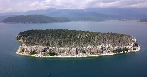
Illustration 1 Golem Grad Island in Great Prespa Lake.
In the northern sector of Great Prespa Lake is the mysterious, densely wooded island of Golem Grad. It was given as a gift to King Alexander of Yugoslavia by King Constantine of Greece in 1922. Covering an area of more than 20 hectares, it is also known as Snake Island due to the large number of reptiles, some poisonous, that inhabit its dense undergrowth. The island is uninhabited and has been so since a small monastic community left in the mid-twentieth century. There are, however, many ancient ru ins, often overgrown by undergrowth, including the remains of Hellenistic buildings and the fourteenth-century church of St Demetrios. In Lesser Prespa is the small wooded island of Agios Achilleos with its Bulgarian Empire and Byzantine remains. There are no cars allowed on the island, so to view the buildings and lake marshes, visitors cross an 850-metres-long wooden pedestrian bridge. This tiny village, with just twenty-one inhabitants, contains the ruins of several Byzantine-period churches, the most significant being the basilica built by the Bulgarian Tsar Samuil before the collapse of his Empire.
After the Balkan Wars (1912–13) and the post–First World War border settlements, Prespa Lake region of historic Macedonia was divided with the northern area becoming a part of the newly established Kingdom of Yugoslavia, the south-western part was incorporated into the newly created state of Albania and the south-eastern corner became part of Greece. The Greek Civil War from 1946 to 1949 brought enormous political and social turbulence to the Prespa Lake region, whose predominantly Macedonian-speaking population suffered very severely and in its aftermath official Greek policy led to either enforced exile or assimilation. Those fighting on the losing side in the Civil War were forced to become refugees and their citizenship and property were confiscated by the Greek state. Some villages were laid waste and the last remaining Slavic, often Bulgarian origin names of the Greek region’s villages that had survived the name-changing decrees of 1926, were changed to Greek names in the 1950s. During the Cold War, and until as late as 1980, the entire Prespa region was considered a military area by the Greek state, with special permission being required for entering the area.
Prespa has been a site of human inhabitation for at least 4,000 years. Since the late 1970s there has been a significant drop in the water level of both Great and Lesser Prespa. In the areas of land that have been reclaimed from the Lakes, recent archaeological discoveries include earthenware pottery, stone tools and wooden boats that date back to the Neolithic and Middle Bronze Age together with roads and buildings from the Roman Empire. Historically, the Prespa region has been subject to various waves of occupation by Romans, Goths, Bulgarians, Serbs, Byzantines and Ottomans, giving the area a rich but also infinitely complex cultural heritage. After the collapse of the Byzantine Empire in the Balkans in the mid-fourteenth century, five centuries of Ottoman rule followed. With Prespa so remote, the Ottoman imperial rule outside the main towns was often inefficient and Prespa always has had a strong open Orthodox Christian presence, with the survival of churches, monasteries and the remains of numerous hermitages some with impressive frescos dating from the fourteenth century.
The local population is concentrated in villages around the two Lakes, where houses are built in a traditional style from stone and clay bricks with roofs of straw or red stone tiles. Prespa’s three main traditional occupations are fishing, animal husbandry and various agricultural activities, particularly the production of the region’s high-quality beans in Greek Prespa. These giant white beans are made into fasolada or gigantes – a national dish which provides the main source of income for farmers. Most of Prespa’s Macedonian settlements north of the Greek border are situated along the shore of Great Prespa where there are fifteen villages: Dolno Dupeni, Ljubojno, Brajcino, Kranj, Slivnica, Kurbinovo, Asamati, Grncari, Ezerani, Perovo, Pokrvenik, Otesevo, Leskoec, Stenje and Konsko. The majority population of these villages is Christian Orthodox Macedonian; however, some have a mixed population with Muslims and a few Turks. Asamati’s inhabitants are divided almost equally between Albanian-speaking Muslims and Orthodox Slavs, while Krani and Grncari are around 70 per cent Muslim and 30 per cent Orthodox. Asamati’s origins are unique. During the Middle Ages, the Prespa region was part of the Bulgarian Empire under Tsar Samuil. After the Battle of Kleidion in 1014 during the Bulgarian-Byzantine wars, some of Tsar Samuil’s soldiers, who were each blinded in one eye, were settled in a village on the shore of Great Prespa. The Byzantines called the village Asamati, meaning ‘settlement of the one-eyed people’. Kurbinovo became widely known when Pablo Picasso visited the village during a Yugoslav peace conference at Ohrid in the 1960s. Many northern Prespa villages have preserved their traditional Macedonian architecture, in particular Brajcino, Ljubojno and Dolno Dupeni.
The largest town in the Prespa region is Resen, Ottoman Resna, which was a significant point near the Roman Via Egnatia road linking Dyracchium – modern Durres in Albania – with Constantinople. The town is known for its apple orchards and has a multiethnic Macedonian, Roma, Albanian and Turkish population. The Albanian inhabitants first settled in Resna/Resen at the beginning of the nineteenth century, while most of the town’s current Turkish-speaking population are descended from either Turks settled in strategic areas under Ottoman rule or ex-Ottoman soldiers or the descendants of local Turkified Slavs. The majority of the Macedonian identity population originates from the villages in the Lake Ohrid area who settled in Resna during the middle of the nineteenth century. North of modern Resen the city of Bitola is an important centre of education, trade and regional government. Once Roman Heraclea Lyncestis, on the Via Egnetia, and medieval and Ottoman Manastir, it occupies a key position on the east-west transport routes linking the Adriatic with the interior of the southern Balkans.
Along the Albanian shore there are seven villages: Bezmisht, Gorice, Gollombec, Shulline, Pushtec, Zaroshe and Rakicke. The most prominent of these villages is Pushtec (called Liqenas in communist Albania), which is well known for its two Byzantine churches, both containing frescos from the twelfth century.4 The majority-ethnic Macedonians exist in some isolation speaking a dialect closely linked to Bulgarian. These remote lakeside villages, reached largely on poor dirt roads, remain largely self-sufficient from mainstream Albania with the population engaged in small-scale agriculture, fishing and animal husbandry as they have done for centuries. They benefit from a much larger area of fertile arable land than the Greek side of Great Prespa Lake at Psarades.5
Despite the intentions of all three neighbouring countries to protect and conserve Prespa’s unique ecosystem, in 2006, a joint Albanian-Greek study raised the alarm about the drying of Lesser Prespa in the Albanian sector of the Lake. The study argued that Lesser Prespa risked being turned into a muddy marshland if it continued to be drained in order to irrigate the agricultural businesses in the Plain of Korca. The ebb of the Lake and the reduction of the water level have produced lavish vegetation mingled with mud, creating a vast expanse of marshland. This has led to a change in the environmental quality of the area with major economic effects. Over the past twenty years south-east Albania has been characterized by massive emigration. Around Korca and Prespa this has left the remaining inhabitants in difficulty due to the poor water resources caused by the drying of Lesser Prespa. According to the study, the deviation of the Drin river bed from its discharge into Lesser Prespa in the mid-1970s has dramatically reduced the environmental, social and economic importance of the Albanian part of the Lake.6
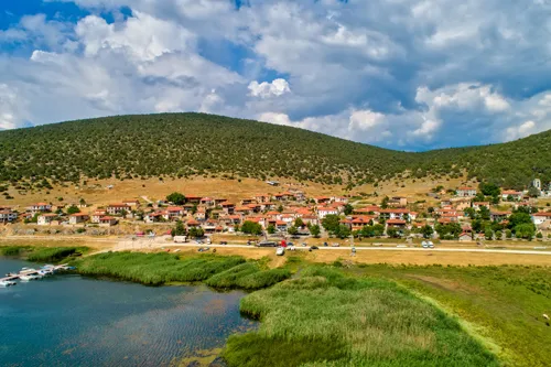
Illustration 2 Psarades village depicting the receding water level of Great Prespa Lake.
In the Greek Prespa region there are thirteen villages surrounding both Great and Lesser Prespa Lakes. For many years, the Greek Lake region was an under-populated, military sensitive area. The entire region remained little developed until the 1980s, when it gradually became promoted as a tourist destination, although numbers today remain very small. The villages are split into those surrounding Great Prespa – Psarades, Vrondero and Pili – and those around Lesser Prespa – Agios Achilleos, Agios Germanos, Laimos, Milionas, Plati, Kallithea, Lefkonas, Karies, Oxia and Mikrolimni. The largest village in Greek Prespa is Laimos, with around 250 permanent residents and together with nearby Agios Germanos making a larger semi-urban centre. It is also the administrative centre of the area. Agios Germanos, with its many well-preserved traditional houses and eleventh-century Byzantine church, is the most frequented by visitors. The village contains a Visitors Information Centre of the management body for the Prespa National Park with details of wildlife and walking trials, as well as a permanent exhibition of the region’s environment and culture.
In the mountains overlooking the Lakes are the ruins of numerous abandoned villages, prominent reminders of the ravages of twentieth-century war and regional political conflicts. In Daseri, near Pili, all that remains are the wall of the school and the stone bases of the houses. In Agathoto are the ruins of a small church, hidden behind rocks and trees. Almost nothing remains of the Latsista settlement, situated among the hills behind the village of Mikrolimni at the tip of Lesser Prespa. Krani, where only a few houses remain, lies a few kilometres further on. Sfika, in the mountains above Oxia, was once quite a large village as can be seen from the size of the church, the ruins of which are hidden deep in the forest.7
The Prespa region is home to four main ethnic/national groups, who see their primary identity as Greeks, Vlachs, Roma or ethnic Macedonians. The latter are the Prespa region’s largest ethnic group. Their ancestors came to the southern Balkans during the Slav and Bulgarian migrations after the fifth and sixth centuries AD. They speak the Slavonic linguistic family Macedonian language that evolved in Yugoslavia from Bulgarian linguistic roots. Those living in the Albanian and Greek villages often speak both Albanian and Greek. Some older generation inhabitants can also speak Hungarian and Czech fluently, owing to their youth in exile after the Civil War. The ethnic Greek population is to a minor extent comprised of people who arrived from Asia Minor during the population exchanges following the First World War and those Vlach Greeks who moved to Prespa from Thessaly and other parts of Greece during the 1950s.
As the Ottoman Empire began to disintegrate in the late nineteenth century, the diverse peoples of Macedonia found themselves caught between Greece and Bulgaria for their sympathies and allegiance. During the Balkan Wars of 1912–13, Greece occupied the territory, now known as the Greek province of Macedonia, and under the Treaty of Bucharest (1912) it became part of the Greek state. After these wars and the First World War, the Slav-speaking population of Prespa and northern Greece generally was greatly reduced. At least 80,000 people were forced to flee to Bulgaria and to the new Turkish Republic under the post-Treaty of Lausanne population exchanges after 1922. The population exchange between Greece and Turkey in 1922 involved the expulsion of more than 40,000 Muslims from Greek Macedonia, thus further altering the population structure of the region. At the same time, the Greek government settled around 560,000 Christians from Turkey and another 50,0...
Table of contents
- Cover
- Half-Title
- Dedication
- Title
- Contents
- List of illustrations
- Preface and acknowledgements
- Maps
- 1 The Prespa Lakes: Ecology and human geography
- 2 The Prespa Lake communities: From prehistory to the Ottoman conquest
- 3 The Prespa Lake communities in the Ottoman Empire, 1380–1863
- 4 Prespa and the struggle for Ottoman Macedonia, 1863–1914
- 5 New nations and new borders divide the Lakes, 1914–23
- 6 Nivica becomes Psarades: The construction of Greek Macedonia, 1924–39
- 7 Prespa during war and Axis occupation
- 8 Freedom and civil conflict, 1945–9: The centrality of Prespa
- 9 Exile and return: The Cold War years, 1950–90
- 10 The Lake world: Conflict in Albania and Yugoslavia, 1991–2001
- 11 The Prespa Lakes: Peace and environmental crisis, 2001–18
- Appendix A: Place-name usage in late Ottoman and twentieth-century Prespa
- Appendix B: Religious and ethnic identities in Prespa villages in RM
- Appendix C: Some non-Greek terms in Prespa and Ohrid region
- Appendix D: The Macedonian toponym
- Notes
- Select bibliography
- Index
- Copyright
Frequently asked questions
Yes, you can cancel anytime from the Subscription tab in your account settings on the Perlego website. Your subscription will stay active until the end of your current billing period. Learn how to cancel your subscription
No, books cannot be downloaded as external files, such as PDFs, for use outside of Perlego. However, you can download books within the Perlego app for offline reading on mobile or tablet. Learn how to download books offline
Perlego offers two plans: Essential and Complete
- Essential is ideal for learners and professionals who enjoy exploring a wide range of subjects. Access the Essential Library with 800,000+ trusted titles and best-sellers across business, personal growth, and the humanities. Includes unlimited reading time and Standard Read Aloud voice.
- Complete: Perfect for advanced learners and researchers needing full, unrestricted access. Unlock 1.5M+ books across hundreds of subjects, including academic and specialized titles. The Complete Plan also includes advanced features like Premium Read Aloud and Research Assistant.
We are an online textbook subscription service, where you can get access to an entire online library for less than the price of a single book per month. With over 1.5 million books across 990+ topics, we’ve got you covered! Learn about our mission
Look out for the read-aloud symbol on your next book to see if you can listen to it. The read-aloud tool reads text aloud for you, highlighting the text as it is being read. You can pause it, speed it up and slow it down. Learn more about Read Aloud
Yes! You can use the Perlego app on both iOS and Android devices to read anytime, anywhere — even offline. Perfect for commutes or when you’re on the go.
Please note we cannot support devices running on iOS 13 and Android 7 or earlier. Learn more about using the app
Please note we cannot support devices running on iOS 13 and Android 7 or earlier. Learn more about using the app
Yes, you can access Lakes and Empires in Macedonian History by James Pettifer,Miranda Vickers in PDF and/or ePUB format, as well as other popular books in History & European History. We have over 1.5 million books available in our catalogue for you to explore.