THIS EBOOK EDITION IS DESIGNED TO BE EXPERIENCED ON COLOUR DEVICES
The practical guide to celestial navigation - know what to do step by step, understand why you're doing it, and be confident that you can put it into practice when on board.
Did you know that a person standing on the equator is effectively travelling at 900mph? And did you know that you can use this information to work out where you are in the world, to an accuracy of about 3 or 4 miles? No GPS, no computers. Just a sextant, some tables from an Almanac and the knowledge in this book.
It's the only back up if the GPS goes down, so it's a matter of safety. If you want to qualify as a commercial skipper/superyacht captain you need to know how to carry out celestial navigation. And if you want to pass the RYA Ocean Yachtmaster™ exam, you need to know it too. It's a major stumbling block for many sailors wanting or needing to take their next qualifications, and the other books on the market are complex and often assume some prior understanding. This book fulfils the need for a clear explanation of celestial navigation, illustrated with colour diagrams and including unique checklist sheets to enable you to repeat all those calculations you learned back at home, when you're on deck.
Without overwhelming the reader with a load of theory from the off, the author breaks down what you need to do, step by step, explaining why at every point – giving the information context, and making it more interesting and memorable. He has trained students in this subject for years, and here he's able to use his experiences of what works, and what are the common pitfalls – he even includes a troubleshooting chapter near the end, going through errors commonly made, and how to spot them. The objective is that readers will finish the book not only knowing what to do, but really understanding why, and being able to make sense of it all again later (rather than just getting through and exam and finding themselves at a loss when on deck). The author also includes time-tested 'proformas' – quick reference sheets that sailors can refer to when they come to putting the theory into practice on board, avoiding the terrifying 'cold start' that most sailors experience when they suddenly need to put their theoretical knowledge to the test in the real world.
eBook - ePub
The Practical Guide to Celestial Navigation
Step-by-step instructions for when you've lost the plot
- 160 pages
- English
- ePUB (mobile friendly)
- Available on iOS & Android
eBook - ePub
The Practical Guide to Celestial Navigation
Step-by-step instructions for when you've lost the plot
About this book
Trusted by 375,005 students
Access to over 1.5 million titles for a fair monthly price.
Study more efficiently using our study tools.
Information

CHAPTER ONE
The basics
Before we head into the realms of this subject, something needs pointing out. The science of celestial navigation is founded on a number of very clever principles linked to the relationship between angles and distances, which, in order to comprehend, requires the understanding of several apparently unconnected relationships. They’re not really unconnected, they wouldn’t be included if they were, but they will appear to be unrelated until you have the full picture. Many publications perhaps fail on this score. You read one chapter of said publication, you understand it. You then move on to the next chapter, fail to make any links and give up – an all too familiar story.
These relationships will be looked at in the following pages. Take them at face value, park them and move on. Only as you move through the book will all these pieces of the jigsaw fit together, and hopefully, with enough time spent pondering the concepts, you too will get that eureka moment.
LATITUDE AND LONGITUDE
In this day and age of electronic navigation aids (GPS and chart plotters), you’d be forgiven for thinking that latitude is just a horizontal line on a chart and longitude just a vertical one. We’re not going back to basics for nothing here, the experience of teaching this subject has proven that this is a common misconception. So, we must remember what they’re really based on. In Figure 1, we have an illustration of the earth. The red line is the equator and the green line the Greenwich Meridian. We’ll be keeping these colours as we build future pictures as it saves lots of labelling and helps with understanding.
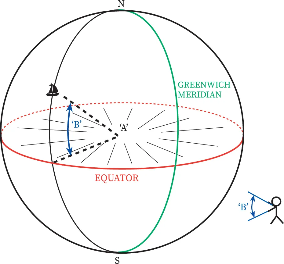
Figure 1
Imagine standing at point A, the centre of the earth. If we were to hold out our arms, pointing one at the vessel and one at the equator, the angle between our arms will be the vessel’s latitude. To put this in more correct terms, the vertical angle subtended between the equator and our vessel is our latitude (somewhere between 0ᵒ and 90ᵒ, which is why we denote the degrees of latitude with two digits, eg 50ᵒ 34.3’ North).
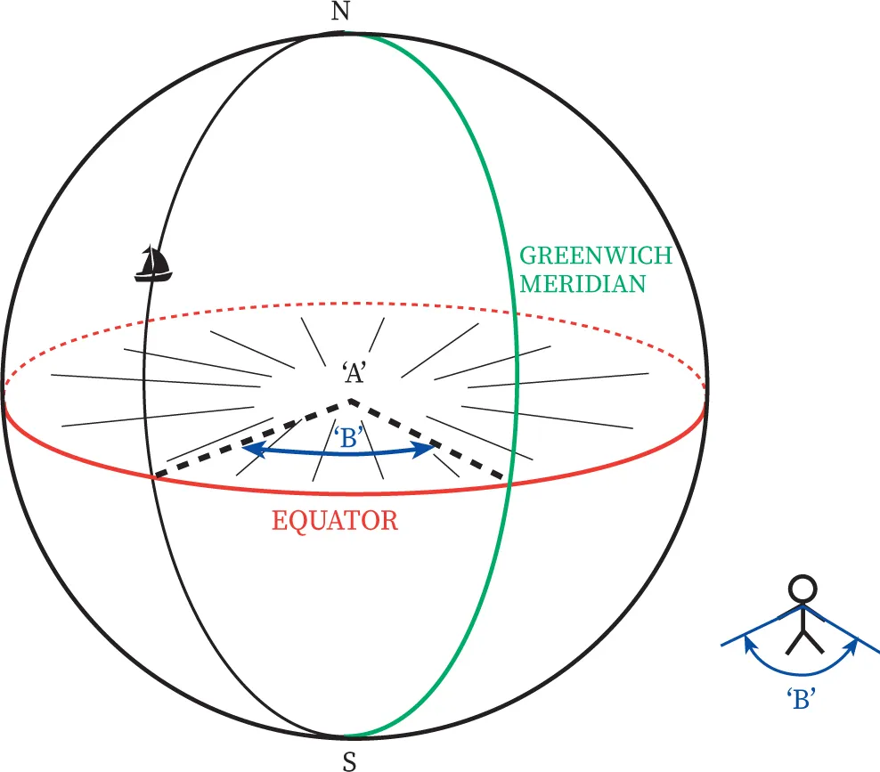
Figure 2
Similarly, looking at Figure 2, if we point horizontally between the Greenwich Meridian and the meridian of the vessel, the angle between our arms is the vessel’s longitude (in this case the longitude is west). It will be somewhere between 0ᵒ and 180ᵒ east or west. Here the degrees have three digits, because the longitude, unlike latitude, can go to three digits, eg 050ᵒ 44.7’ East.
EARTH ROTATION
Now that we’re getting the idea of these angles subtended at the centre of the earth, let’s have a look at its rotation.
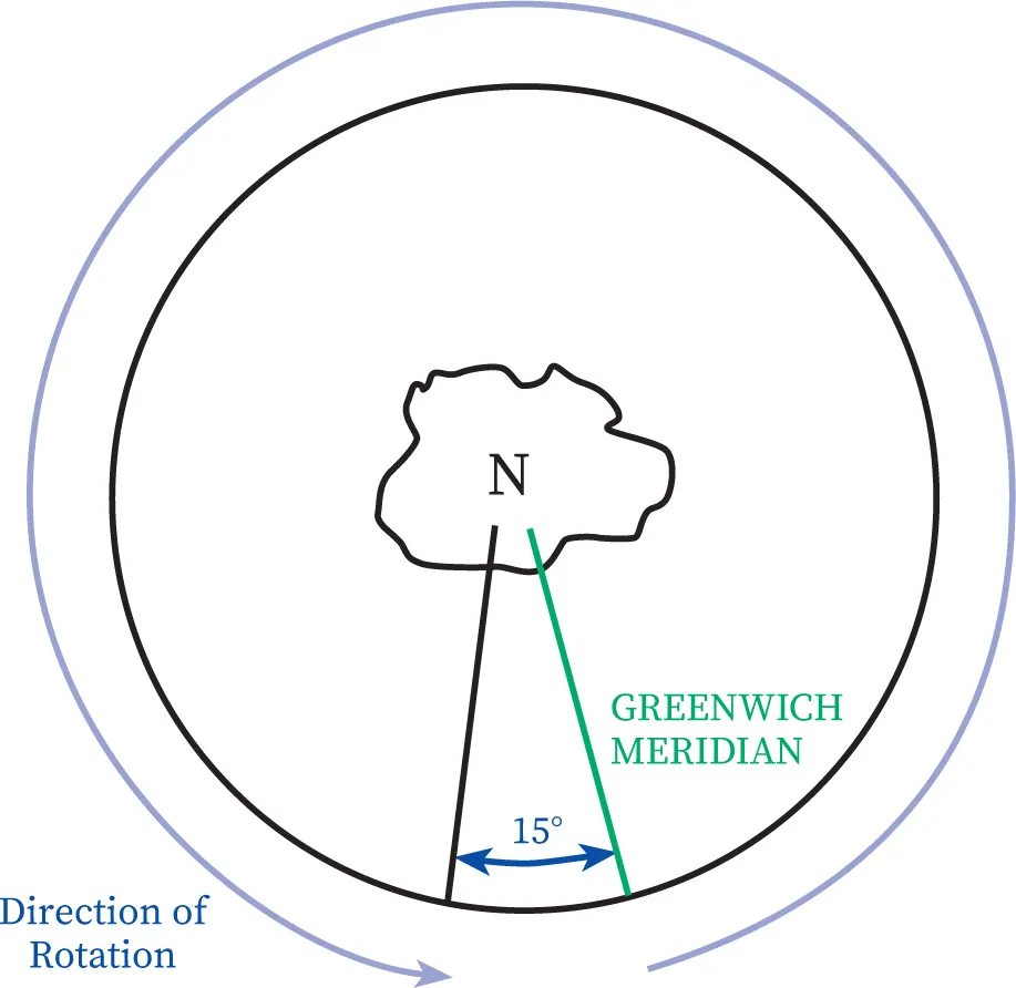
Figure 3
Figure 3 is a ‘top down’ view of the earth. In other words, we’re looking down at the North Pole. So, we know the earth takes 24 hours to rotate through a complete revolution (actually it takes 23 hours and 56 minutes, but let’s forget about that for these purposes). Table 1 shows this revolution. It takes 24 hours to rotate through 360 degrees. Perhaps a lesser known fact is that during that 24 hours, someone standing on the equator will have travelled 21,600nm (ignoring the earth travelling through space). Or to put it another way, the circumference of the earth is 21,600nm (The earth in actual fact is not completely round, it is slightly squashed at the poles and is known as an oblate ellipsoid or spheroid. This deformation is, however, too small to be of concern to us.)

| ANGLE | TIME | DISTANCE |
| 360° | 24hr | 21,600nm |
| 15° | 1hr | 900nm |
| 1° | 4min | 60nm |
| 60’ | 4min | 60nm |
| 15’ | 1min | 15nm |
| 1’ | 4sec | 1nm |
Table 1
Looking down, we see it takes one hour for the earth to rotate through 15 degrees, covering a distance of 900nm at the equator. In other words, a person stood on the equator is travelling at 900 miles per hour.
One degree takes four minutes and covers a distance of 60nm.
60 minutes (which is, of course, a degree) also takes four minutes and a distance of 60nm.
Carrying on do...
Table of contents
- Cover
- Title Page
- Contents
- About the author
- Acknowledgements
- Introduction
- Chapter 1 The basics
- Chapter 2 Foundation of celestial navigation and the geographical position
- Chapter 3 Defining the geographical position
- Chapter 4 Sextant corrections
- Chapter 5 The PZX triangle
- Chapter 6 The intercept method
- Chapter 7 Sight Reduction Tables
- Chapter 8 Undertaking a full sight reduction
- Chapter 9 Sun sight reduction – Quick Start and recap
- Chapter 10 Meridian passage
- Chapter 11 Meridian passage – Quick Start and recap
- Chapter 12 Plotting
- Chapter 13 Compass checking
- Chapter 14 Time
- Chapter 15 Sextant: Practical aspects of sight taking
- Chapter 16 Troubleshooting
- Appendices
- Glossary
- eCopyright
Frequently asked questions
Yes, you can cancel anytime from the Subscription tab in your account settings on the Perlego website. Your subscription will stay active until the end of your current billing period. Learn how to cancel your subscription
No, books cannot be downloaded as external files, such as PDFs, for use outside of Perlego. However, you can download books within the Perlego app for offline reading on mobile or tablet. Learn how to download books offline
We are an online textbook subscription service, where you can get access to an entire online library for less than the price of a single book per month. With over 1.5 million books across 990+ topics, we’ve got you covered! Learn about our mission
Look out for the read-aloud symbol on your next book to see if you can listen to it. The read-aloud tool reads text aloud for you, highlighting the text as it is being read. You can pause it, speed it up and slow it down. Learn more about Read Aloud
Yes! You can use the Perlego app on both iOS and Android devices to read anytime, anywhere — even offline. Perfect for commutes or when you’re on the go.
Please note we cannot support devices running on iOS 13 and Android 7 or earlier. Learn more about using the app
Please note we cannot support devices running on iOS 13 and Android 7 or earlier. Learn more about using the app
Yes, you can access The Practical Guide to Celestial Navigation by Phil Somerville in PDF and/or ePUB format, as well as other popular books in Technology & Engineering & Aviation. We have over 1.5 million books available in our catalogue for you to explore.