- English
- ePUB (mobile friendly)
- Available on iOS & Android
eBook - ePub
Trusted by 375,005 students
Access to over 1.5 million titles for a fair monthly price.
Study more efficiently using our study tools.
Information
EARTH (TERRA)
Earth is our planet, and the best way to appreciate its uniqueness is through images made from space. This stunning image of Earth is by the DSCOVR satellite from its orbit 1,449,293 km (900,549 miles) away from Earth (see Fig. 264).

Figure 264
This image shows Africa’s barren Sahara Desert and the dense, cloud-covered forests of Central Africa. Ice-covered Antarctica is at the bottom of the image (south). The Mediterranean Sea is above Africa (north). The Atlantic Ocean is left (west). And the Indian Ocean is right (east). The presence of the atmosphere is made known by the white clouds that swirl over a significant fraction of this view of our planet. Astronomers have found many planets in orbit around distant stars. If an Earth-like planet exists, with land masses of solid rock, oceans of liquid water, and a temperature-regulating and life-sustaining atmosphere, it has yet to be found.
From a human perspective, the surface of Earth provides the foundation for environmental science. Therefore, we shall begin this unit with a brief review of Earth’s place in the solar system, the seasons, the minerals and rocks that form Earth’s crust, and the forces that modify their physical nature and appearance. We will then consider Earth’s ecology, and we will explore many of the ways in which people modify Earth’s surface to extract its resources, build structures and transportation networks, produce and distribute energy, raise crops and livestock, and dispose of waste.
Our occasional guide will be the great naturalist John Muir. While he never saw the Earth from the vantage point of a satellite or a mission to the moon, he would not have been surprised by the DSCOVR image of Earth, for in 1915, he wrote the following in Travels in Alaska
When we contemplate the whole globe as one great dewdrop, striped and dotted with continents and islands, flying through space with other stars all singing and shining together as one, the whole universe appears as an infinite storm of beauty.
You can learn about Muir and his legacy at the Sierra Club’s John Muir Exhibit which is the source of Muir’s quotations in this unit.
Earth’s Place in the Solar System
The solar system consists of the sun and the various bodies that orbit around it. These include the major planets and their moons, the minor planets, a belt of asteroids, comets, and dust. Mercury is the closest planet to the sun. Venus is next, followed by Earth and Mars. Earth completes its orbit around the sun in 365.2422 days Therefore, an extra day is added to the calendar every four years to give what is called a leap year. But even this correction is slightly off. The National Institute of Standards and Technology explains how it’s corrected
Only every fourth century year (those equally divisible by 400) is a leap year. For instance, 2000 was a leap year, but 1900, 1800 and 1700 were not.
Geographic Coordinates
It’s important to be able to precisely specify the location of any place on Earth, especially since place names are only approximations, and the same name may identify several places. The solution is to identify the location of a place by its geographic coordinates.
The Equator is an imaginary line around the circumference of the Earth, centered between the north and south poles. The Equator and imaginary parallel lines around the Earth above and below the equator form latitudes. As shown in this interactive diagram by NOAA the Equator is 0° latitude, and New Orleans is approximately at 30° north (see Fig. 265). The North Pole is 90° north and the South Pole is 90° south.
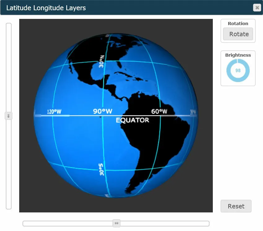
Figure 265
The diagram also shows longitudes, imaginary vertical lines encircling the Earth from the North Pole to the South Pole. The longitude of New Orleans is approximately 90° west. The latitude and longitude of a specific location on Earth are known as its geographic coordinates. The coordinates of New Orleans are approximately 30° N and 90° W. Enter these coordinates into the Google Earth search box, and you will be taken to a field 122 meters (400 feet) south of Terminal Road in the eastern half of New Orleans. Most Global Positioning System (GPS) receivers provide the coordinates of the receiver’s location to within several meters (yards). Thus, a GPS receiver or smart phone equipped with a GPS and taken to this location would give its coordinates as 30° N, 90° W.
The Seasons
The seasonal changes in sunlight, temperature, precipitation, and the growth of plants play major roles in Earth’s environment. These changes are modulated by Earth’s orbit and the planet’s tilt. None of the planets orbits the sun in a perfect circle. The orbit of Earth around the sun is a slightly flattened ellipse with a perihelion (minimum distance from the sun) of 147.5 million km (91.65 million miles) during January and an aphelion (maximum distance from the sun) of 152.6 million km (94.8 million miles) during July.
The orbital change in Earth’s distance from the sun causes the maximum intensity of sunlight at the surface of Earth to vary from +3.5% to -3.5%. However, because Earth is tilted 23.5 degrees with respect to the plane of its orbit, the fact that the Northern Hemisphere is angled toward the sun during July makes it “summer” in that hemisphere then, even though Earth is also at aphelion (farthest from the sun) at that time. At least this has long been the traditional explanation for this apparent contradiction.
Solar scientist Roy Spencer has expanded on this contradiction and offered an explanation in an interview for The Distant Sun in NASA Science News. Spencer explains:
The average temperature of the whole earth at aphelion is about 4°F or 2.3°C higher than it is at perihelion.
How can this be? The answer is because there is more land in the Northern Hemisphere than in the Southern Hemisphere. Spencer continues:
Earth's temperature (averaged over both hemispheres) is slightly higher in July because the Sun is shining down on all that land, which heats up rather easily.
A solstice occurs when Earth is tilted its maximum 23.5° with respect to the sun. The northern-summer solstice is June 21, and the northern-winter solstice is December 21. Both solstices are illustrated in this NASA diagram (see Fig. 266)

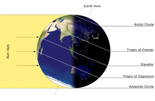
Figure 266
Note that two key latitudes on either side of the Equator are assigned special names:
- Arctic Circle: 66.5° north. The sun is not visible above this latitude during northern winter
- Tropic of Cancer: 23.5° north. The sun is directly overhead at the northern-summer solstice
- Tropic of Capricorn: 23.5° south. The sun is directly overhead at the northern-winter solstice
- Antarct...
Table of contents
- Front Cover
- Title Page
- Copyright Page
- Dedication
- Table of Contents
- Acknowledgments
- About
- Meet the Author
- Air
- Earth
- Fire
- Space
- Water
Frequently asked questions
Yes, you can cancel anytime from the Subscription tab in your account settings on the Perlego website. Your subscription will stay active until the end of your current billing period. Learn how to cancel your subscription
No, books cannot be downloaded as external files, such as PDFs, for use outside of Perlego. However, you can download books within the Perlego app for offline reading on mobile or tablet. Learn how to download books offline
Perlego offers two plans: Essential and Complete
- Essential is ideal for learners and professionals who enjoy exploring a wide range of subjects. Access the Essential Library with 800,000+ trusted titles and best-sellers across business, personal growth, and the humanities. Includes unlimited reading time and Standard Read Aloud voice.
- Complete: Perfect for advanced learners and researchers needing full, unrestricted access. Unlock 1.5M+ books across hundreds of subjects, including academic and specialized titles. The Complete Plan also includes advanced features like Premium Read Aloud and Research Assistant.
We are an online textbook subscription service, where you can get access to an entire online library for less than the price of a single book per month. With over 1.5 million books across 990+ topics, we’ve got you covered! Learn about our mission
Look out for the read-aloud symbol on your next book to see if you can listen to it. The read-aloud tool reads text aloud for you, highlighting the text as it is being read. You can pause it, speed it up and slow it down. Learn more about Read Aloud
Yes! You can use the Perlego app on both iOS and Android devices to read anytime, anywhere — even offline. Perfect for commutes or when you’re on the go.
Please note we cannot support devices running on iOS 13 and Android 7 or earlier. Learn more about using the app
Please note we cannot support devices running on iOS 13 and Android 7 or earlier. Learn more about using the app
Yes, you can access Environmental Science by Forrest M. Mims III in PDF and/or ePUB format, as well as other popular books in Biological Sciences & Environmental Science. We have over 1.5 million books available in our catalogue for you to explore.