Xinjiang, the vast northwestern region comprising one sixth of the PRC today, borders on India, Pakistan, Afghanistan, Tajikistan, Kyrgyzstan, Kazakstan, Russia and Mongolia. Since antiquity it has stood at the crossroads between China, India, the Mediterranean and Russia. In recent decades its historic silk road linkages have grown increasingly global, with issues of energy, development, separatism and terrorism bringing the region into the news. James Millward draws on primary sources and scholarly research in several European and Asian languages to provide the first general account in English of the history of Xinjiang and its peoples from earliest times to the present.
He discusses Xinjiang’s world historical role as a commercial entrepot and cultural conduit by which Buddhism, Christianity and Islam entered China and its interactions with Tibetan, Mongol and other Inner Asian empires as well as with Chinese dynasties. Eurasian Crossroads also examines the competing Chinese and Turkic nationalist visions of the region’s status in modern times and the recurring dissent and rapid development under the PRC. Within the broad perspective of this book it emerges that the factors underlying historical change in the region – its natural environment and geography, its physical location at the overlap of cultural realms and its legacy of ethno-linguistic diversity – remain as relevant to Xinjiang’s future as to its past.
Trusted by 375,005 students
Access to over 1.5 million titles for a fair monthly price.
1. Ancient Encounters (earliest times–8th century)
Writers have attached a number of metaphors to Xinjiang. It is the hub of the Silk Road, the crossroads of Asia, the heart of the continent. Owen Lattimore—caravaneer, Inner Asianist and, according to Senator Joseph McCarthy, ‘the top Soviet espionage agent in the United States’—called Xinjiang the ‘pivot of Asia’.1 Some might question Lattimore’s assessment of the region’s geopolitical significance in the mid-twentieth century. Nevertheless, when viewed broadly, the idea behind all these labels is clear enough: Xinjiang’s centrality and intermediate position in Eurasia. This book is devoted to examining the region’s ‘betweenness’ over a long chronological perspective. A good place to begin is from another sort of long perspective, from a satellite above the earth at the beginning of the twenty-first century.
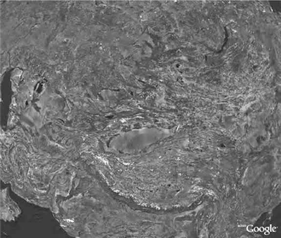
A glance at a satellite image or topographical map of Eurasia reveals the dense knot of mountains at the continent’s core. These mountains define Xinjiang as we know it: the region is a rough triangle consisting of three basins, the Tarim to the south, Turfan (Turpan) to the south-east, and Zungharian to the north. The Kunlun range and its eastern offshoot, the Altyn Tagh, form the southern boundary of the Tarim Basin, and the Tianshan forms its northern edge, dividing the Tarim Basin from Zungharia. The Altai range divides Zungharia from Mongolia on the north-east. To the south-east, the Quruq Tagh, a spur of the Tianshan, separates the Tarim and Turfan Basins.
Satellite image of Xinjiang, Central Eurasia and environs (Google Earth, published with permission)
Xinjiang thus defined by mountain ranges is a relatively recent geological creation. It is not, for example, the Xinjiang known by Tienshanosaurus or other dinosaur species from the Jurassic and early Cretaceous whose remains have been found there.2 In fact, what most dramatically distinguishes Tienshanosaurus’ home some 160 million years ago from the Xinjiang we know are precisely those mountain ranges, the high ground at the centre of Asia. The Qinghai-Tibetan plateau, the world’s highest place, and the landform which, along with Antarctica and the Arctic, exercises the most climatic influence on earth, began to rise some 100 million years ago with the subduction of the Indian plate under Eurasia and the breaking away of the Indian continent from Gondwanaland. India sped north and collided at high-speed (up to 15 cm per year) some 60 million years ago with continental Asia, there joining South China and North China, which had themselves only relatively recently met and taken their place at the Eurasian table. The Indian collision lifted the Qiangtang plateau of northern Tibet and raised mountain ranges in a series of folds across the centre of Eurasia.
The uplift continued, by twenty-two to fifteen million years ago reaching a threshold height that created the Asian monsoon weather pattern. In this weather cycle, warm and moist air from the Indian and Pacific oceans is drawn in the spring and summer into the Indian sub-continent and East Asia by rising air masses over Tibet and Mongolia, bringing the monsoon rains. In the autumn and winter, cool high pressure zones centred on the high Inner Asian regions block warmer, moister air from the sea, causing relatively dry winters in Asia. The mountains and the monsoon climate they produced have profoundly affected the history of Asia, influencing everything from agriculture to navigation in the Indian ocean and South China Sea to, arguably, social and political structures in eastern and southern Asia.
We may thus add another metaphor: if Tibet is the roof of the world, Xinjiang lies in its eaves. This tectonic and orographic history has also shaped Xinjiang’s history, albeit in a fashion diametrically opposed to that of areas lying closer to the sea: the mountains ringing Xinjiang and lower ranges further east create a barrier effect, shielding the Tarim Basin from south-easterly winds and the influence of the monsoons that determine China’s and India’s climate. Moreover, whereas long-term shifts to warmer temperatures have increased precipitation in the rest of China, such climatological changes have increased aridity and desertification in Xinjiang. Conversely, climatic cooling produces aridity in eastern China but increases precipitation and glaciation in Xinjiang’s highlands. The mountains, then, separate the Xinjiang region from the climatic regime of eastern and southern Asia.3
In fact, Xinjiang lies at the midpoint of two climatic belts extending across Eurasia’s midriff. A climatic map of Eurasia reveals a series of horizontal bands. Furthest north lies the arctic tundra; below that, a strip of coniferous forests, or taiga, comprising most of Siberia. The next band, a belt of steppe grasslands reaching from northern Mongolia in the east to Hungary in the west, crosses northern Xinjiang. South of that lies the band of deserts running from the Gobi to the shores of the Caspian and contiguous with the Arabian peninsula, north Africa and the Sahara. This band, of course, runs through southern Xinjiang.
The populous societies that have formed the civilisational cores of world history lie around the rim of the continent. Xinjiang lies between them, astride the steppe and desert bands, and roughly equidistant from the population cores of China, India and the Mediterranean basin. I will make a good deal of these geographic facts underlying Xinjiang’s centrality in the narrative that follows, but won’t be the first to capitalise on them: entrepreneurial Chinese geographers have recently determined that the ‘exact’ geographical centre of Eurasia lies in a newly developed theme-park located a convenient distance from the tourist hotels of Urumchi (Ürümchi).
THE GEOGRAPHIC SETTING
With an area of 1,664,900 square kilometres, Xinjiang is the size of Great Britain, France, Germany and Spain—or Texas, California, Montana and Colorado—combined. If it were a country, it would be the world’s sixteenth largest, just smaller than Libya and just larger than Iran. Xinjiang comprises one sixth of the land area of the PRC (People’s Republic of China), yet in the year 2000 was home to only 1.5 per cent of China’s population.4 Although official PRC sources claim the region has been part of China since 60 BCE, its population has only in the past century become Chinese-speaking, and the region remains, by Chinese standards, sparsely settled.
The Xinjiang region was not an integrated political unit with its current boundaries until the eighteenth century. Before then, control of the territory was usually divided among many local oasis rulers or warring empires; parts of Xinjiang were often ruled together with lands in what are now the Central Asian Republics, and parts by China or Tibet. Nevertheless, there is a geographic, cultural and geopolitical coherence to the region that makes writing its history over the very long term a reasonable thing to attempt.
With its snowy mountains and dry basins Xinjiang is home to both the second highest and the second lowest places on Earth. To the north-east the Altai range rises to 4,000 metres, forming the border with Mongolia. The Tianshan range running east-west–down the middle of the region has peaks of up to 7,000 metres at its higher western end; the landmark Boghda shan (5,445 metres) is visible on rare clear days from Urumchi. The Kunlun range, to the south, divides Xinjiang from the Tibetan plateau and includes the world’s second-highest peak, Mt Godwin Austen (Qiaogeli, 8,611 metres). In the south-west, routes over the high Pamir plateau skirt peaks of 7,500 metres en route to Kashmir, Pakistan and Afghanistan.
The Zungharian (Jungharian, Dzungarian) Basin, or Zungharia, making up the Xinjiang region’s northern half, is bounded by the Altai and Tianshan ranges. Although parts of this basin are desert, much is prime grassland, and some areas support agriculture, especially the fertile valley of the Yili (Ili) river in the south-west. The Yili drains west into Lake Balkash in what is today Kazakhstan. Northern Xinjiang’s other major river, the Irtysh, likewise flows west, filling Lake Zaysan and continuing on to the north-west to Semey (Semipalatinsk) and on past Omsk into Russian Siberia. In fact, along much of its western edge the Zungharian Basin opens without obstacle into Kazakhstan’s Semirech’e (Yettisu, Seven Rivers) region. Zungharian grasslands have through history generally formed a single unit with the watersheds of the Talas, Chu and other Semirech’e rivers; with these rich pastures to keep their herds strong, nomad powers could dominate both southern Xinjiang and the heartland of western Turkestan, a region now divided among Uzbekistan, Tajikistan and Kyrgyzstan.
Several passes through the Tianshan link northern and southern Xinjiang, permitting the passage of merchants and warriors. Towards the east, where the city of Urumchi is located today, a large corridor opens southward into the Turfan Depression, which lies between the main chain of the Tianshan and a south-eastern spur, known as the Quruq (Kuruk) mountains, which divide Turfan and Hami from the rest of southern Xinjiang. Ayding Kol, a salt lake at the bottom of the depression, lies at 154 metres below sea level—only the Dead Sea is lower. Although the desert surrounding Turfan is unforgiving and summer temperatures in the region can approach 50 degrees Celsius, ample water made the Turfan and surrounding oases a rich agricultural area, one which nomadic powers to the north coveted for the produce and tribute they could exact. For centuries farmers in the Turfan area dug and maintained underground canals called karez to tap underground reservoirs filled by mountain run-off and to water their fields with a minimum of evaporation. From Turfan a long desert road leads to the Gansu corridor and thence to the interior provinces of China. Some Chinese dynasties established fortifications along this corridor: Jiayuguan, some 700 kilometres east of Turfan, marks the westernmost extent of the Ming dynasty great wall. Other dynasties, notably the Han and Tang, made the Turfan Depression itself a base of operations.
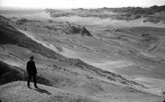
West of Turfan and the low Quruq Tagh range is the Tarim Basin, also known as Altishahr. This southern half of Xinjiang is dominated by the vast Taklamakan Desert (327,000 sq km), a sand-trap surrounded by mountain ranges that cast an almost total rain shadow from north, west and south. The shifting sand dunes of the Taklamakan can reach 100 metres in height. Encroaching sands have buried towns, and seasonal sandstorms, called qara buran, ‘black winds’, have asphyxiated travellers caught without shelter. But the mountains that starve the Tarim Basin of precipitation also provide the snow and glacial run-off that it lives on. The Khotan, Yarkand, Kashgar, Aksu and many smaller rivers feed into the Tarim River, which drains the west and north of the basin in a clockwise direction before emptying south-east into the desert. Around the Tarim Basin stretch a chain of oases, some spring-fed, others supported by mountain run-off. These oases have provided the grain and other products needed by nomads from the north, as well as tribute to military conquerors. They also facilitated trade: the caravan routes running through the ancient cities along the southern and northern rims of the Tarim Basin comprise the central stretches of the Silk Road. Passes through the Pamir and Karakoram ranges allowed communication between the Tarim Basin and Afghanistan, India and Pakistan as well as with what are now collectively referred to as the former Soviet Central Asian Republics, especially Kyrgyzstan, Kazakhstan, Uzbekistan and Tajikistan. Historically, both classical Greco-Roman and Arab sources referred to the heartland of these ‘stans’ as ‘the land beyond the river’, referring to the Oxus or Amu river. For convenience below I use the English version of this term, Transoxiana, to refer to the region between the Amu Darya and Syr Darya (darya means ‘river’), an area that includes the Ferghana Valley as well as the cities of Tashkent, Samarkand and Bukhara.
With only 20–150 mm of annual precipitation, the Tarim Basin today supports agriculture only in the piedmont zone, where extensive irrigation can harness the glacier- and snow-melt from the Kunlun, Pamir and Tianshan mountains. Though run-off levels are currently stable, they have fluctuated in the past, with dramatic effects on human habitation in the southern Tarim. Remains of Niya, Dandan-oilik, Endere and other sites deep in the Taklamakan are evidence of times when greater volumes of water brought the rivers flowing out of the Kunlun well north of their current termini. Climatic changes in the late third and late eighth centuries led to the abandonment of these cities to the desert. The desiccated city of Loulan (Kroraina, Krorän) in the south-east of the Taklamakan, once capital of the Shanshan kingdom and a vigorous trade entrepôt, is further testimony to the vagaries of water in southern Xinjiang. When the Tarim and Kongque River system shifted course to the south-east around 330 CE, its terminal lake, Lop Nor, disappeared, leaving Loulan high and dry. Abandoned by its people, Loulan settled into the shifting sands until rediscovered at the turn of the twentieth century.5
The Taklamakan Desert at Mazartagh (photo: J. Millward, 1992)
Since the eighteenth century Qing and subsequent Chinese authorities have expanded the agricultural capacity of the Tarim Basin through vigorous development of hydraulic works. This process accelerated after 1949. But as the Tarim is an ancient sea and an entirely inland drainage, salinisation and alkalisation plague up to a third of arable land—its telltale w...
Table of contents
Cover
Title Page
Copyright
Contents
List of Illustrations
List of Maps and Figures
Preface and Acknowledgements
Preface to the Second Edition
Maps
1. Ancient Encounters (earliest times–8th century)
2. Central Eurasia Ascendant (9th–16th centuries)
3. Between Islam and China (16th–19th centuries)
4. Between Empire and Nation (late 19th–early 20th century)
5. Between China and the Soviet Union (1910s–1940s)
6. In the People’s Republic of China (1950s–1980s)
7. Between China and the World (1990s–2000s)
8. Colonialism, Assimilationism and Ethnocide (2000s–2020s)
Appendix: Xinjiang Historical Timeline
General Bibliography
Index
Frequently asked questions
Yes, you can cancel anytime from the Subscription tab in your account settings on the Perlego website. Your subscription will stay active until the end of your current billing period. Learn how to cancel your subscription
No, books cannot be downloaded as external files, such as PDFs, for use outside of Perlego. However, you can download books within the Perlego app for offline reading on mobile or tablet. Learn how to download books offline
Perlego offers two plans: Essential and Complete
Essential is ideal for learners and professionals who enjoy exploring a wide range of subjects. Access the Essential Library with 800,000+ trusted titles and best-sellers across business, personal growth, and the humanities. Includes unlimited reading time and Standard Read Aloud voice.
Complete: Perfect for advanced learners and researchers needing full, unrestricted access. Unlock 1.5M+ books across hundreds of subjects, including academic and specialized titles. The Complete Plan also includes advanced features like Premium Read Aloud and Research Assistant.
Both plans are available with monthly, semester, or annual billing cycles.
We are an online textbook subscription service, where you can get access to an entire online library for less than the price of a single book per month. With over 1.5 million books across 990+ topics, we’ve got you covered! Learn about our mission
Look out for the read-aloud symbol on your next book to see if you can listen to it. The read-aloud tool reads text aloud for you, highlighting the text as it is being read. You can pause it, speed it up and slow it down. Learn more about Read Aloud
Yes! You can use the Perlego app on both iOS and Android devices to read anytime, anywhere — even offline. Perfect for commutes or when you’re on the go. Please note we cannot support devices running on iOS 13 and Android 7 or earlier. Learn more about using the app
Yes, you can access Eurasian Crossroads by James A. Millward,James A. Millward in PDF and/or ePUB format, as well as other popular books in History & Chinese History. We have over 1.5 million books available in our catalogue for you to explore.