Since the first publication of this landmark textbook in 2004, it has received high praise for its clear, comprehensive, and practical approach. The second edition continues to offer a unique framework for teaching and learning interdisciplinary environmental planning, incorporating the latest thinking, newest research findings, and numerous, updated case studies into the solid foundation of the first edition.
The book has been reorganized based on feedback from instructors, and contains a new chapter entitled "Land Use, Energy, Air Quality and Climate Change." Throughout, boxes have been added on such topics as federal laws, state and local environmental programs, and critical problems and responses.
This new edition addresses three broad subject areas. Part I, "Environmental Planning and Management," provides an overview of the field, along with the fundamentals of land use planning, and presents a collaborative approach to environmental planning. Part II, "Sustainable Land Use Principles and Planning Analysis," considers environmental and geospatial information; soils, topography, and land use; stream flow, flooding, and runoff; stormwater management and stream restoration; groundwater hydrology; landscape ecology; wildlife habitats and biodiversity; energy, air quality and climate change; and methods for land analysis. Part III, "Managing Watersheds, Ecosystems and Development to Achieve Sustainable Communities," explains the principles of ecosystem management, restoration, and protection; land conservation; and the mitigation of natural hazards.
With this thoroughly revised second edition, Environmental Land Use Planning and Management maintains its preeminence as the leading textbook in its field.
Trusted by 375,005 students
Access to over 1.5 million titles for a fair monthly price.
Environmental Planning: Technical Principles and Analysis
5
Environmental Data and Geospatial Analysis
This chapter begins Part II, which focuses on the scientific principles and technical analysis involved in environmental land use planning and management. Environmental science and engineering principles and data analysis are critical to the methods presented in the chapters on soils, geology, hydrology, ecology, natural hazards, and climate change (Chapters 6–13). Chapter 14 addresses the integration of environmental and spatial information, including measurable indicators that clarify and compare community sustainability and track change and progress.
First we must introduce fundamental concepts, sources, and analysis of information, especially geospatial data. This chapter presents some general considerations in information gathering and data analysis and then reviews the exploding field of geospatial analysis, remote sensing, and geographic information systems: the geospatial revolution. We begin with a vision statement presented by then Vice President Al Gore in his now famous January 1998 speech on “The Digital Earth” at the California Science Center in Los Angeles, a time when few conceived of even Google Earth, which was launched 7 years later. Our current geospatial revolution has progressed far closer to Al Gore’s vision of the Digital Earth than anyone would have predicted in 1998.
Imagine a young child going to a Digital Earth exhibit at a local museum. After donning a head-mounted display, she sees Earth as it appears from space. Using a data glove, she zooms in, using higher and higher levels of resolution, to see continents, then regions, countries, cities, and finally individual houses, trees, and other natural and man-made objects. Having found an area of the planet she is interested in exploring, she takes the equivalent of a “magic carpet ride” through a 3-D visualization of the terrain. Of course, terrain is only one of the many kinds of data with which she can interact. Using the systems’ voice recognition capabilities, she is able to request information on land cover, distribution of plant and animal species, real-time weather, roads, political boundaries, and population. She can also visualize the environmental information that she and other students all over the world have collected as part of the GLOBE project. This information can be seamlessly fused with the digital map or terrain data. She can get more information on many of the objects she sees by using her data glove to click on a hyperlink. To prepare for her family’s vacation to Yellowstone National Park, for example, she plans the perfect hike to the geysers, bison, and bighorn sheep that she has just read about. In fact, she can follow the trail visually from start to finish before she ever leaves the museum in her hometown.
She is not limited to moving through space, but can also travel through time. After taking a virtual field-trip to Paris to visit the Louvre, she moves backward in time to learn about French history, perusing digitized maps overlaid on the surface of the Digital Earth, newsreel footage, oral history, newspapers and other primary sources. She sends some of this information to her personal e-mail address to study later. The time-line, which stretches off in the distance, can be set for days, years, centuries, or even geological epochs, for those occasions when she wants to learn more about dinosaurs [or forward in time to view scenarios for those occasions when she wants to see what the future may hold and what she can do about it]. (Gore 1998)
Information and Data Analysis in Environmental Planning
Pragmatic environmental problem solving requires science- and fact-based technical information on which to base decisions and actions. Environmental planners are generally the gatekeepers of information (as well as managers of misinformation), and they must be adept at gathering, analyzing, interpreting, integrating, and presenting information. In a land use context, much of this information is spatial and is best represented in maps and spatial images.
The integration of spatial, scientific, engineering, and economic information with normative perceptions and values is challenging because of the wide range of both quantitative and qualitative information. The planning process determines the type and specificity of information needed. As shown in Box 2.1, Scoping (Step 0) identifies data needs and develops a work plan for collecting and analyzing data. Analysis (Step 2) focuses on information gathering and analysis. This activity continues throughout the planning process.
A Tiered Process
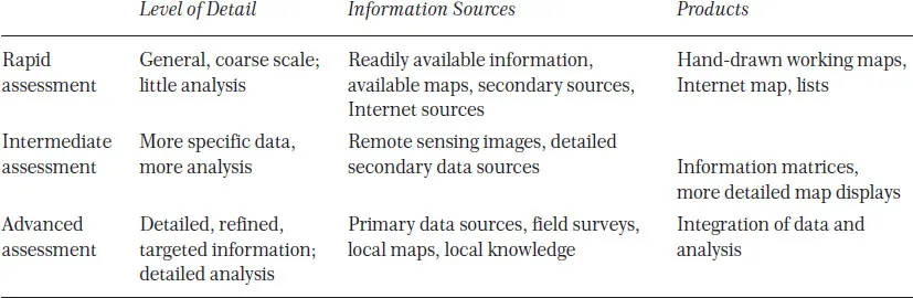
Information gathering and assessment often follow a tiered process, first by looking at readily available and general information, followed by increasing levels of detail (Table 5.1). Many studies start with rapid assessment, which takes a quick look at problems and available information and moves quickly to initial action (Sayre et al. 2000). Although moving to action quickly has advantages, rapid assessment should also identify needs for more detailed analysis to follow. This is sometimes referred to as data gap analysis, or the identification of data gaps in need of filling.
Intermediate and advanced assessment involves increasing levels of detail, more analysis, and more sophisticated data products. The first step is gathering basic data, such as maps or remotely sensed information on topography, soils, geology, and land use/land cover. This inventory may also include more specific information on wetlands, habitats, and culturally significant areas acquired from field monitoring or the local knowledge of citizens.
TABLE 5.1 Tiered Approach to Information Gathering and Analysis
Analytical studies prioritize and interpret the data, and generally aim to make sense of the information. Specific data and mapped products are determined by the planning objectives. For example, assessing environmentally sensitive and critical areas may require information on land use, land ownership, development infrastructure, population growth, and other factors influencing land use change. Methods such as build-out and environmental impact assessment can clarify possible future effects.
Subsequent chapters describe specific data gathering, analysis, and display methods used for planning studies involving soils (Chapter 6), stormwater quantity and quality (Chapters 7 and 8), groundwater (Chapter 9), watersheds (Chapters 7 and 19), landscape and urban ecology (Chapters 10 and 19), urban forestry (Chapter 10), wetlands (Chapter 10), wildlife habitat (Chapter 11), energy and climate change (Chapter 12), natural hazards (Chapter 13), and land suitability (Chapter 14).
Considerations and Pitfalls in Using Data and Information
The proper use, the accuracy, and the documentation of land-related information depend on several data issues that should be considered throughout the planning and analysis processes, especially in the early stages. These issues include data form, scale, accuracy, coverage, completeness, age, confidentiality, maintenance, paper-trail-to-sources, communication, and appropriateness (Hirschman et al. 1992).
1. Form. Are the data digital (e.g., georeferenced in a database), spatial (e.g., on a map), temporal (e.g., plotted on a graph with a time dimension), or a combination of these? Are data qualitative (e.g., groundwater moves rapidly) or quantitative (e.g., flow is 50 ft per day)?
2. Scale. How large or small is the mapped representation of a given land area? If two maps are the same size, the large-scale map will represent less land than the small-scale map. Accordingly, the large-scale map is more detailed. This is important when overlaying maps of different scale.
3. Accuracy. How well do the data and/or the mapped locations of features reflect their actual existence or location on the land surface (or how much “slop” is there in the mapped representation)? For example, map units in a soil survey (see Chapter 6) are commonly accurate to 2 acres. Differing accuracies of data sets become important when comparing or overlaying information. Note that accuracy is the degree of agreement between sample or map data and reality, and precision is how well you can reproduce the data values that you measure, monitor, or map.
4. C...
Table of contents
Cover
Title Page
Copyright
Dedication
Contents
Preface
Acknowledgments
I. A Framework for Environmental Land Use Planning and Management
II. Environmental Planning: Technical Principles and Analysis
III. Planning, Design, and Policy Tools for Environmental Land Management
References
Index
Frequently asked questions
Yes, you can cancel anytime from the Subscription tab in your account settings on the Perlego website. Your subscription will stay active until the end of your current billing period. Learn how to cancel your subscription
No, books cannot be downloaded as external files, such as PDFs, for use outside of Perlego. However, you can download books within the Perlego app for offline reading on mobile or tablet. Learn how to download books offline
Perlego offers two plans: Essential and Complete
Essential is ideal for learners and professionals who enjoy exploring a wide range of subjects. Access the Essential Library with 800,000+ trusted titles and best-sellers across business, personal growth, and the humanities. Includes unlimited reading time and Standard Read Aloud voice.
Complete: Perfect for advanced learners and researchers needing full, unrestricted access. Unlock 1.5M+ books across hundreds of subjects, including academic and specialized titles. The Complete Plan also includes advanced features like Premium Read Aloud and Research Assistant.
Both plans are available with monthly, semester, or annual billing cycles.
We are an online textbook subscription service, where you can get access to an entire online library for less than the price of a single book per month. With over 1.5 million books across 990+ topics, we’ve got you covered! Learn about our mission
Look out for the read-aloud symbol on your next book to see if you can listen to it. The read-aloud tool reads text aloud for you, highlighting the text as it is being read. You can pause it, speed it up and slow it down. Learn more about Read Aloud
Yes! You can use the Perlego app on both iOS and Android devices to read anytime, anywhere — even offline. Perfect for commutes or when you’re on the go. Please note we cannot support devices running on iOS 13 and Android 7 or earlier. Learn more about using the app
Yes, you can access Environmental Land Use Planning and Management by John Randolph in PDF and/or ePUB format, as well as other popular books in Architecture & Architecture General. We have over 1.5 million books available in our catalogue for you to explore.