The new fifth edition of this leading textbook provides a clear and comprehensive account of governance and politics in the Netherlands. The book has been revised throughout to provide full coverage of recent developments and events, including the latest proposals for constitutional reform.
The Netherlands has often been characterized as a place of political calm, with a culture of cooperation and compromise in dealing with key political issues. Now, at a time when climate change and immigration are high on the political agenda, the electorate is growing ever more unpredictable and political fragmentation makes forming majority coalitions increasingly difficult, it is vital to question how the Dutch system will continue to achieve consensus. With this in mind, the authors take a comparative and analytical approach as they examine the features of the country's political system that have long made it a subject of study for political scientists.
Governance and Politics of the Netherlands provides both students and scholars with a complete and reliable introduction to a country whose small size belies its importance in comparative political analysis.
New to this Edition:
- Fully revised and updated throughout to reflect the latest developments, events and issues.
- Cites the most recent data sources (e.g. national election study and parliamentary study).
- Discusses latest proposals for constitutional reform.

- 303 pages
- English
- ePUB (mobile friendly)
- Available on iOS & Android
eBook - ePub
Governance and Politics of the Netherlands
About this book
Trusted by 375,005 students
Access to over 1.5 million titles for a fair monthly price.
Study more efficiently using our study tools.
Information
1 The Country, the Nation, and the State
A ‘SMALL’ COUNTRY
The Netherlands is a country with a surface area of some 42,000 square kilometers located by the North Sea around the Rhine–Meuse estuary. By some standards, the country is not particularly large, and the Netherlands is often referred to, even by the self-deprecating Dutch, as a ‘small’ country. Granted, the area is about twice the size of Wales or half that of Scotland, and equal to the size of the states of Massachusetts, Connecticut, and Rhode Island combined. Yet, a definition of size that relies only on landmass is far too limited. Even though just over 4,000 square kilometers of this area is uninhabitable, as it is covered by the water of rivers, canals, and lakes, the remaining space is used with great efficiency to provide homes for 17.4 million people. With an average of 512 people per square kilometer, it is one of the most densely populated countries in the world. In terms of inhabitants, it has 1.5 times the population of Belgium or Portugal, more than twice the population of Austria or Switzerland, and more than Norway, Denmark, and Finland combined. From the seventeenth to the twentieth century, the country controlled a large colonial empire, and today the gross domestic product (GDP) of the Netherlands is among the highest in the world (17th or 18th). ‘Small’ is thus quite relative, and in some respects, it is one of the ‘largest’ countries of the world.
Whether one chooses to call the country ‘large’ or ‘small,’ the amount of land would have been smaller without the efforts of its population. Virtually no discussion of the Netherlands is complete without reference to the well-known adage, ‘God made the world, but the Dutch made Holland.’ By draining lakes and marshes to create new land, the Dutch may have had more impact on the shape of their country than other peoples, but whoever may be said to have made it, we have the problem of what to call it. The official name is the Kingdom of the Netherlands, but legally this also includes municipalities and independent countries in the Caribbean. In colloquial speech, it is often called Holland, but this is actually the name of its once most famous province. The French call the country ‘Les Pays-Bas,’ but this translates into ‘the Low Countries’ in English, and is then usually meant to include Belgium. In this book, we shall refer to the polity as ‘the Netherlands.’ Its 12 modern provinces are shown in capitals in Map 1.1. Thus, while there are many themes that could be used to begin a discussion of the political system of the Netherlands, the interplay of geography and people may serve as well as any other. There is little doubt that, in their little corner of the world, the land contributed to shaping the people and the people have helped to shape the land. Understanding this relationship will help the reader to understand the society and politics of the country.
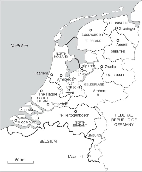
Map 1.1 The Netherlands: provinces and major cities
THE STRUGGLE AGAINST THE WATER
Of course, the land area of the world began to take shape before people could have much influence on it. In many areas of the world, this shape has changed little since the prehistoric days that determined its form. In others, the interplay of factors such as earthquakes, volcanic eruptions, and/or water altered the land even during the period of recorded history. The area of land identified as the Netherlands falls into the latter group.
During the Ice Age, British and Scandinavian glaciers grew together, blocking the North Sea. The courses of the Rhine and Meuse Rivers were altered, though, as the ice melted, they partially returned to their old courses. The glaciers also brought the sand that began to form what have become the higher, southern provinces of the country. As the climate warmed and the ice melted, peat bogs began to form, first in the western part of the country, and later towards the east. In places, the sea flooded areas that had once been above water (Van Valkenburg, 1943; Keuning, 1965).
When the sea broke through the connection between England and France, the force of the water in the channel brought sand from the south and created the walls of sand dunes that are still characteristic of the Dutch coastline. Behind the dunes, there was a large lagoon that gradually began to fill with sand and soil brought by the rivers from higher ground. Peat bogs, swamps, and lakes characterized the land behind the dunes.
The earliest inhabitants of the lowlands were tribes who came to the area to hunt reindeer. Gradually, the hunters and fishermen were joined by farmers and cattle herders. Sometime after 100 BC, four waves of immigration took place: three Germanic from the north and one Celtic from the southeast. The Greeks had vague ideas of the existence of the lands of the Celts, but it was Julius Caesar’s Roman expeditions that brought the first direct contact between the inhabitants of the great civilizations and those of the lowlands. With the Romans also came the first recorded history of the area in the works of Tacitus and Pliny. It was the former who wrote of the legendary Batavians. Caesar and his successors pushed northward to the banks of the Rhine, but to the Romans the area had little meaning other than the furthest extension of their empire to the north.
The Rhine and Meuse Rivers provided natural barriers to the Romans, and while the armies of Augustus crossed the rivers and included the Frisians in his empire, the Romans later pulled back and never really made subjects of the inhabitants to the north. As Vlekke has written, ‘the Romans set little store by the marshlands of the west and the north of the Low Countries which held no allure for them’ (Vlekke, 1943).
Assaults by German tribes and by the sea finally drove the Romans from the area. The Franks gradually gained in power and pushed the Frisians back to the north, so that the Frankish Kingdom of Charlemagne and his successors included much of the Low Countries. Frankish power brought with it the introduction of Christianity to the region. Frankish domination, however, did not greatly affect the social institutions of the people. The marshy areas of the north and west did not facilitate the kind of large land ownership that was necessary to support feudalism, so this social system was never fully established in these areas. No nobility developed in what later became the provinces of Holland, Zeeland, and Utrecht; instead, the Low Countries remained a territory of small landowners and free peasants. In remote areas of the north, free peasants were able to continue as democratic peasant republics for centuries. The area was less conducive to the development of a manorial system than to the development of cities, which sprang up at virtually every juncture of waters and at every harbor.
Three times in history, the sea broke through the natural protective dunes to alter the landscape. About 300 BC, the sea broke through via the estuaries of the Scheldt, Meuse, and Rhine to inundate areas in the southwest of the country. The second principal incursion of the sea occurred about 270 AD, and was a key factor in driving the Romans from the area. The third period of incursion began in the tenth or eleventh century and resulted in the flooding of large areas – creating, for example, the islands in the current provinces of South Holland and Zeeland. In the north, areas of dunes were washed away; now only small islands formed by the remnants of these dunes indicate where the coast once was. Behind these islands, new seas (or bays) were created, the largest of which was the Zuiderzee, which expanded over a few centuries to cover a substantial area of the north of Holland.
This last incursion led the increased populations of the area to take protective measures that were to alter the landscape. In about the eleventh century, the first dikes were built to protect inhabited areas from flooding (Vlekke, 1943; Keuning, 1965). The threat of water came from three sources. In addition to the threat from the sea, there was the threat of periodic flooding from the great rivers. Moreover, the surplus of yearly rainfall had to be disposed of lest large areas revert, at least seasonally, to swamps. Thus, the systems of dikes were extended to cover increasingly large areas, and methods, including the use of windmills, were devised to drain off surplus water. By combining the use of dikes and drainage systems, areas of land could be reclaimed from the sea and from lakes.
From the very beginning, the battle against water was not something that could be left to an overlord (or a little boy putting his finger in the breached dike), but required the combined efforts of the population. Since everyone behind the dike profited, maintenance could not justifiably be left only to those whose land bordered the water. Water control boards were organized with the responsibility of maintaining the system. It is often claimed that, dating back at least to the thirteenth century, these were the first democratic organizations in the country and one of the oldest forms of democracy in Northern Europe.
Nature has thus left those who inhabit the area with what may justly be described as the ‘nether lands’ or ‘lowlands.’ No point is higher than about 30 meters above sea level. In the northern and western parts of the country, most of the area ranges between 0 and 2.5 meters below sea level. In some larger areas that have been drained, the level is even lower; the region in which Amsterdam’s Schiphol Airport is located lies 4.2 meters below sea level, and new areas have been created that once lay under as much as 6.9 meters of the waters of the Zuiderzee (Keuning, 1965).
Today, though windmills no longer play a role in the system, dikes and drainage systems must nevertheless be maintained. More than half of the country must be protected artificially against water incursion, and more than half of the population live in areas that would be under water, at least at high tide, if protection were not maintained. In 1994 and 1995, some towns and polders behind river dikes became flooded, and the government hastily began a campaign to reinforce and heighten the dikes. There are dormant plans to drain another portion of the former Zuiderzee, and proposals have been made to relocate Schiphol Airport to an island to be built off the North Sea coast. It is the long history of the struggle against the water through the building of dikes and land reclamation through drainage that gives rise to the saying that ‘the Dutch built Holland.’
THREE BOUNDARIES
Both the people and nature have interacted to shape the land. However, the mere shape of the land is not the only factor of importance in understanding the relation between geography, social structure, and politics. There are no mountains or natural boundaries separating the Dutch from their neighbors, and even modern satellite photographs will not reveal the important boundaries that separate peoples and have such an important impact on them. In the area of the Rhine River Delta, three boundaries – linguistic, religious, and political – divide the peoples of the lowlands. The fact that these three boundaries do not coincide influences the politics of both the Netherlands and its southern neighbor, Belgium, even today.
The Boundaries of Language and Religion
In his discussion of ‘The Borders of the Netherlands,’ De Vrankrijker (1946) distinguishes ‘structural borders,’ which he defines as natural borders or those resulting from geographical position, and ‘historical borders,’ which simply through their long existence gain permanence and acceptance. The Rhine and Meuse Rivers provided structural borders for the Romans, and though they never really subjugated the inhabitants to the north, they did leave a lasting imprint by building a highway from Cologne through Aachen and Tongeren to Bavai in northern France and on to the sea coast.
The building of this highway, and the Roman colonization along its route, was one of the most important events in the history of the Netherlands. It determined the furthest extent of Germanic influence in the northwestern corner of the European continent, and fixed for many centuries to come the dividing line between Romanic and Germanic peoples in this area (De Vrankrijker, 1946).
The Roman highway and the structural border of the rivers thus introduced two rough, but discernible, dividing lines between north and south. To the north, Germanic influences prevailed; to the south, the Romans imposed their authority and customs. The highway became the boundary between Germanic and Romanic languages; to the north, Dutch is spoken, and to the south, French. The rivers were to become the border between Rome and the Reformation, between Catholicism and Protestantism. As n...
Table of contents
- Cover
- Halftitlepage
- Series
- Titlepage
- Copyright
- Dedication
- Contents
- List of Features
- Preface to the Fifth Edition
- Acknowledgements
- 1 The Country, the Nation, and the State
- 2 A Country of Minorities
- 3 Political Parties and the Party System
- 4 Elections
- 5 The Core Executive
- 6 Parliament
- 7 The Policy-Making Process
- 8 Multilevel Governance
- 9 Economic and Welfare Policy
- 10 Foreign Policy
- 11 Evaluating Consensus Government
- Further Reading
- Bibliography
- Index
Frequently asked questions
Yes, you can cancel anytime from the Subscription tab in your account settings on the Perlego website. Your subscription will stay active until the end of your current billing period. Learn how to cancel your subscription
No, books cannot be downloaded as external files, such as PDFs, for use outside of Perlego. However, you can download books within the Perlego app for offline reading on mobile or tablet. Learn how to download books offline
We are an online textbook subscription service, where you can get access to an entire online library for less than the price of a single book per month. With over 1.5 million books across 990+ topics, we’ve got you covered! Learn about our mission
Look out for the read-aloud symbol on your next book to see if you can listen to it. The read-aloud tool reads text aloud for you, highlighting the text as it is being read. You can pause it, speed it up and slow it down. Learn more about Read Aloud
Yes! You can use the Perlego app on both iOS and Android devices to read anytime, anywhere — even offline. Perfect for commutes or when you’re on the go.
Please note we cannot support devices running on iOS 13 and Android 7 or earlier. Learn more about using the app
Please note we cannot support devices running on iOS 13 and Android 7 or earlier. Learn more about using the app
Yes, you can access Governance and Politics of the Netherlands by Rudy B. Andeweg,Galen A. Irwin,Tom Louwerse in PDF and/or ePUB format, as well as other popular books in Politics & International Relations & European Politics. We have over 1.5 million books available in our catalogue for you to explore.