![]()
The aim of this chapter is to briefly present the Île-de-France region at the end of the decade 2010–20 and to set out the politico-institutional framework within which the actors and the ongoing public policies operate. First, however, I need to clearly define the territory that we are discussing.
There is heated debate about the geographical boundaries of the Paris metropolis, because there is a strong political dimension to these boundaries – as will be evident throughout this book. That is why, before developing our analysis of France’s leading metropolitan region, it will be helpful to briefly specify its contours and to explain the choice of our territory of study. The Institut national de la statistique et des études économiques (INSEE) defines the functional territory of French cities through the notion of the “urban area” (aire urbaine), which it defines as
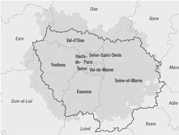
Under this definition, the Paris urban area comprises almost 12.5 million inhabitants distributed across some 1,800 municipalities and an area of land of a little more than 17,000 sq. km. It extends over almost the entire Île-de-France region (98.8 per cent of municipalities) and over a very small part of the seven départements surrounding it.
In this book, the choice is to focus almost exclusively on the Île-de-France region, thus treating it as equivalent to the Paris urban area. The reasons for this choice are, first, that there is a fairly good match between the territory of Île-de-France and the Paris urban area (see Map 1.1) but, above all, because Île-de-France is the scale used by the authorities – and, in particular, by the government – in applying its policies, and it corresponds to the scope of the decision-making and consultative structures not only of the political institutions but also of the economic community and civil society. In other words, it is the yardstick territory and makes sense for all the actors concerned with the smooth operation and development of the Paris metropolis.
Population, society and economy of Île-de-France today
As of 2019 the population of Île-de-France was some 12.3 million people. They represent 19 per cent of the national population in a space of 12,000 sq. km – i.e. only 2 per cent of the area of the country. The core of the territory, the most built-up, most populous and densest part, is home to some 6.8 million people, namely 56 per cent of the population of Île-de-France in an area of only 760 sq. km – in other words, in just over 6 per cent of the land area of the region. It corresponds to what is called the “inner ring”, by contrast with the “outer ring”, which is much less densely populated and more rural, especially in its southern and eastern parts. In other words, just 27 per cent of Île-de-France consists of built-up areas, as against 48 per cent farmland and 24 per cent natural zones.
Île-de-France is made up of eight départements. Broadly, four of them (Paris, Val-de-Marne, Hauts-de-Seine and Seine-Saint-Denis) represent the inner ring and four others (Essonne, Yvelines, Val-d’Oise and Seine-et-Marne) the outer ring (see Map 1.1).
Table 1.1 Population of the départements of Île-de-France, 2019
| Surface area (sq. km) | Population | Population density (pers/sq. km) |
Paris | 105 | 2,148,300 | 20,460 |
Seine-et-Marne | 5,915 | 1,423,600 | 241 |
Yvelines | 2,284 | 1,448,600 | 634 |
Essonne | 1,804 | 1,319,400 | 731 |
Hauts-de-Seine | 176 | 1,613,800 | 9,169 |
Seine-Saint-Denis | 236 | 1,670,100 | 7,077 |
Val-de-Marne | 245 | 1,406,000 | 5,739 |
Val-d’Oise | 1,246 | 1,248,400 | 1002 |
Île-de-France | 12,012 | 12,278,210 | 1,022 |
The city of Paris, which was both a municipality and a département until 2018,1 has a population of slightly under 2.2 million in an area of 105 sq. km. It is the most heavily populated département. With a density of 20,460 people per square kilometre, it is one of the world’s densest municipalities (New York: 7,100; Tokyo: 6,300; London 5,600). It is by far the largest municipality. The other “big” municipalities in the region range in population size around just 100,000 inhabitants (Boulogne: 119,000; Saint-Denis: 111,000; Argenteuil: 108,000; Montreuil: 108,000; Nanterre: 94,000).
In social terms, Île-de-France is characterized by an apparently paradoxical situation that can be found in many big world cities. It is a rich region where poor populations nevertheless constitute a large proportion of its inhabitants. So, with disposable per capita income of some €24,190 in 2017, it leads the way among the regions of France, where the national average stands at €21,415, and €19,378 excluding the Île-de-France region (INSEE). Almost 64 per cent of the region’s inhabitants pay income tax, as compared with only 52 per cent nationwide. On the other hand, poverty levels there are higher, affecting almost 15.3 per cent of the population in 2017, as compared with only 14.5 per cent for the country as a whole.
With respect to income, jobs and qualifications, therefore, there are sharp inequalities – both social and territorial – in Île-de-France, and notably a substantial disparity between the east and west of the region (see Chapter 2).
In terms of economic power, Île-de-France is by far France’s leading region. With a GDP of almost €710 billion in 2018 (Choose Paris Region 2020), it accounts for almost a third (31.1 per cent) of national wealth. Its per capita GDP is €58,300, well above the French national average of €32,900. It is France’s richest region. Its economy has shifted sharply towards services in recent decades, with almost 87 per cent of added value coming from the service sector (much more than the national average), in this respect following the trend of most of the world’s other metropolises. It retains a fairly dynamic industrial sector, however, which accounts for about 9 per cent of regional GDP (see Chapter 4).
This economy is not evenly spread across the region, however. There is a sharp disparity between the east and west of the region, with jobs concentrated in Paris and in Hauts-de-Seine, which together provided almost a half of the region’s employment in 2018, confirming a trend that goes back several decades (see Chapter 2). This situation causes a recurrent problem for the development of the region in so far as the gap between the location of the jobs (more to the west) and the location of populations (more to the east) is steadily growing, a problem we shall return to in Chapters 5, 6 and 7.
Île-de-France is one of the world’s most powerful metropolitan areas, whose economic, political, scientific and cultural influence owes more and more to its integration into the global community (see Chapter 4). As such, it is the only French global city.
The politico-institutional organization of Île-de-France
In order to manage this global metropolis, Île-de-France possesses a complex politico-institutional structure, to which we shall return in the chapters that follow. In this chapter, the objective is to present the main institutions and political players, as well as the major economic and social actors who participate in the governance of the region. How they interact will be analysed in subsequent chapters.
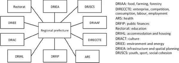
First, central government has a strong presence, much more so than in France’s other big cities, notably because its territory encompasses Paris, the national capital. The presence of central government is revealed first of all through its administration, both central administration with the ministries, but also at local level with a regional prefecture and seven prefectures of départements. The prefect of the region is also the prefect of Paris. The regional prefecture employs several thousand civil servants who are spread across some ten regional directorates, notably covering agriculture and food, infrastructure and spatial planning (see organization chart in Figure 1.1), social cohesion, culture, the economy and employment, the environment and energy, education, housing, health, etc. Some of these directorates also exist at the level of the départements. This local administration of the state is very powerful. It is in charge of implementing state policies, monitoring state monies and subsidies to local authorities. It is also significantly involved in local policies; for instance, the regional master plan is elaborated in parallel by the regional council and the regional prefecture.
In addition to the regional prefecture and its directorates, the state is present through the Préfecture de police de l’agglomération parisienne, which is in charge of the policing and security of the 6.8 million people of the inner ring. Established in 1800 on the sole territory of the Paris municipality, the préfecture’s jurisdiction was extended to encompass the whole inner ring in 2009. It is composed of about 44,000 staff, including some 25,500 police and 8,400 firefighters.
In addition, central government is present through its control over many public institutions, agencies and enterprises, mainly in the fields of energy, transportation, communications and spatial planning. Its presence is also felt as the main landowner through several public entities, such as the national railways (SNCF) and the army. Here again, we will return to these different structures in the course of the book. The state is therefore a powerful and essential player in the governance of Île-de-France.
For their part, the local authorities are represented by the region, the départements, and the municipalities. The region, established in 1982 by the most important laws on decentralization, has a deliberative body, the regional council, elected by direct universal suffrage under proportio...