![]()
1
VINEYARD NOMENCLATURE
The derivation of the names of various Vineyard venues is fascinating. The island itself, the towns, streets and community sites, all contribute to the panoply of intriguing names. While people are well aware of the name of a given town, not everyone knows the backstory; that’s its hidden history.
When Captain Bartholomew Gosnold sailed his ship Concord along Cape Cod in 1602, he observed grapes growing in abundance on an island shore. What a good place for a vineyard, he thought. (That was 350 years before Chicama Vineyards began, had a nearly forty-year run and folded in 2008.) Gosnold started a little settlement on a nearby island, Cuttyhunk. He and his crew constructed a fort, planted crops and harvested sassafras. (Sassafras was a cash crop for Europeans, brewed as a tea to ease the pain of gout and combat syphilis.) Gosnold and his men lacked sufficient supplies to remain on Cuttyhunk, so after six weeks, they returned to England.
Gosnold named the larger island Martha’s Vineyard in honor of his mother-in-law, Martha Golden, who financed his expedition. Gosnold’s wife was also named Martha, as were two of his daughters. The first Martha died as an infant; another daughter was named Martha as well. An apocryphal line about a third daughter, Nancy, claims that when Gosnold discovered another island farther east, Nan took it (Nantucket). The Elizabeth Islands, on the western side of Vineyard Sound, were named for another Gosnold daughter, Elizabeth, not, as generally assumed, the reigning queen of England.
NOEPE
Wampanoag, the local tribe of Native Americans, means “easterners” or “people of the dawn.” When the sun rises, it first strikes the people of the East, the people of Martha’s Vineyard, the Wampanoag.
Native Americans lived here even before the island became an island. When the oceans rose about 3000 BC, the high land of the Vineyard was surrounded by water. Native Americans called it Noepe, which translates to “land amid the waters.” The Wampanoag gathered fish and shellfish from the nearby waters.
Native American names predominate on the Vineyard. “The great majority of these [Vineyard place names] are of Indian derivation. Altered in their spelling until they are not recognizable in their original form or pronunciation, abbreviated and clipped short at both stem and stern, yet these old Algonquin place names survive.”1 Vineyarders treasure the past.
At the western end of the island is the fishing village Menemsha. The name referred to the view of the harbor from nearby Peaked or Prospect Hill.2 According to historian Charles Banks, “The name originally did not belong to the creek or the pond, but probably indicated a standing tree or pole placed on one of the hills near the creek, or it may have been the name of the locality itself, ‘as seen from afar.’”
Cape Higgon, off North Road in Chilmark, evolved from the Wampanoag word Keephikkon, which means “fenced enclosure.”
The great tidal pond Sengekontaket, behind State Beach, is quite shallow, making it ideal for shell fishermen to wade in for their catch. People in the Wampanoag settlement on the shores feasted on shellfish.
Squibnocket Pond, near the Chilmark-Aquinnah town line, is the largest freshwater pond on the Vineyard. It was once an arm of the ocean, an inland harbor of salt water where the Wampanoag gathered shellfish, as evidenced by middens of shells along the shoreline, dating back seven thousand years. Squibnocket means “where the red ground nut grows.” Native Americans relished this red lily, with long, stem-like roots, akin to nuts.
Today, Squibnocket Pond is fresh water. A stream leads to Menemsha Pond, which affords herring passage for their annual rite to spawn. They swim up through a huge pipe under State Road, migrating from salt water to fresh.
The Wampanoag fished at Quansoo, once known as Quannaimes, where they caught “the long fish,” or eel. Today, Quansoo is a quiet area, south of Nab’s Corner, on South Road in Chilmark, a peninsula preserved by two conservation organizations, Sheriff’s Meadow and the Land Bank.
Among the chain of Elizabeth Islands are Naushon, which means “middle”; Penakese; Nashawena; and Uncatena. All bear Wampanoag names. Cuttyhunk, where Gosnold temporarily settled, means “lies out in the sea.”
At the eastern end of Noepe lies Chappaquiddick, or “separated island.” This separation fluctuates, as the long sandbar of Norton Point at times connects Chappy to Edgartown proper, creating the basin of Edgartown Harbor. Other times, the point is breached, which allows Edgartown Harbor to open and the currents to wash through the break, creating challenges for the Chappy ferry. Pocha, similar to Poucha Pond, means “breaking in,” which refers to a beach opening.
Tashmoo, in Vineyard Haven, once a freshwater pond, is now an arm of the ocean. Known as “the great spring” in the Wampanoag language, it was a settlement with access for fishing and fresh water. Nearby archaeological digs have uncovered charred fire pits and bones of whitetail deer, evidence of a Wampanoag settlement.
Sepiessa is a Land Bank property off New Lane in West Tisbury by Tisbury Great Pond. Of its derivation, Michael West, who writes under Sepiessa Press, quoted Charles Banks, from 1911: “The modern abbreviation of the neck is ‘Sissa.’ John Manter sold land on Tississa, in the Point called Sepiessa, alias Manter’s Point.”3 West added, “I would guess that ‘Sep’ may then refer to something ‘extended or stretched out.’ Putting this all together, I say that Sep + iessa = stretched out or extended neck of land.”
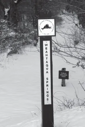
Weahtaqua Springs Preserve is a thirty-five-acre property, owned by the Martha’s Vineyard Land Bank in Oak Bluffs, nestled by the roundabout near the center of the island. Photo by Joyce Dresser.
Weahtaqua (wee-uh-TOCK-wuh) “earned its name from a Wampanoag word meaning head of the Lagoon, which it overlooks. The land sits atop myriad springs which flow into nearby Stepping Stones Brook. A beech grove is emerging in the forest, which is bedecked with reindeer lichen and bearberry.”4
At the most southeasterly corner of the Vineyard, along South Beach, a romantic Native American legend enlivens the story of Katama, the Wampanoag word for “crab fishing place.” An Indian maiden, Katama, fell in love with Mattakessett, son of the sachem in a nearby village. Because they knew they could not marry, they swam out to sea. The Spirit of the Sea, Paumpagussit, welcomed them beneath the light of Nanepaushat, the moon. The spirits of Katama and Mattakessett live on as dolphins, frolicking in the waters off Katama.
MARTHA’S VINEYARD
Martha’s Vineyard was settled in 1642 by Thomas Mayhew, an Englishman who bought the island to convert the Native Americans to Christianity. Along with his son, Thomas Jr., he set about his task, instituting English laws and customs, as well as the fervent Calvinist goal of creating a Christian community among the Wampanoag. Mayhew preached with his Bible, rather than coerced with the bullet, and succeeded in taking control of Martha’s Vineyard without firing a gun.
In the mid- to late 1600s (1664–80), the colony of New Amsterdam was ceded to the Duke of York. The people of New Amsterdam curried favor with the duke, destined to become England’s King James II (1685–88). New Amsterdam was renamed New York in his honor. Royal names were assigned to New York counties: Kings, Queens and Dutchess.
The Duke of York purchased Martha’s Vineyard for £3,500. Martha’s Vineyard, the Elizabeth Islands and Nantucket became Dukes County. The name evolved into County of Dukes County. Dukes County Avenue and County Road in Oak Bluffs and Old County Road in West Tisbury honor the Duke of York. Kings Highway follows suit.
Great James Pond, by Lambert’s Cove Beach, was named for the Duke of York. In 1700, it was called Pond Royall. Once there was discussion about opening the pond to the ocean to create a harbor for West Tisbury, but the plan was defeated.
When James, Duke of York, assumed ownership of Dukes County, Thomas Mayhew petitioned for the political, economic and judicial control of the community. The Duke granted Mayhew his wish. Thus, Mayhew assumed the title of governor, although he was neither elected nor appointed to the position.
TOWN NOMENCLATURE
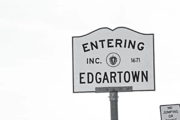
A key name change occurred in the seventeenth century. Edgartown was known as Nunnepog, or “freshwater place.” Mayhew called it Great Harbour, and it was once known locally as Old Town. In 1664, the town was renamed to honor the Duke of York. Initially, it was to be Jamestown, but there already was a Jamestown in the colony of Virginia. Hence, it was decided to recognize the son of James, Duke of York, who was expected to grow up to be king himself. James had four sons. One of them, little Edgar, was two years old when the town was named for him in 1669. He died at the age of four in 1671, so Edgar Towne, now Edgartown, honored the young prince who never grew up to be king. This is the only Edgartown in the world.
In 1642, Thomas Mayhew alighted on the shores of what they called Great Harbour, now known as Edgartown. Photo by Joyce Dresser.
Three Vineyard towns took names from England. Tisbury was named for the English town of Tisbury, Wiltshire, where Thomas Mayhew was born in 1593. Author/historian Charles Banks visited Old Tisbury England. He found in William the Conqueror’s DoomsDay Book the town was spelled Tisseburie. Banks wrote, “Tisbury is situated in a beautiful garden spot, a rolling country, the South Downs of England, noted for the special sheep raised in that section. It is probable that the early practice of raising sheep on our island was brought here through Governor Mayhew.”5
Tisbury Harbor was called Holmes Hole. In the last century and a half, it has become known as Vineyard Haven, the popular appellation for the town as a whole.
Chilmark also has English ancestry. In England, Chilmark was adjacent to the ancestral home of Thomas Mayhew, near Salisbury. On the Vineyard, Josiah, son of Miles Standish of Plymouth Plantation, first settled Chilmark in the 1660s. The town was incorporated in 1694 when it separated from Tisbury.
For two centuries, the Vineyard was made up of three sprawling towns: Edgartown, Tisbury and Chilmark. It was not until the late nineteenth century that three more towns came into existence.
West Tisbury, the second Vineyard settlement, was known as New Town. It was the southern section of Tisbury and separated in 1892. There is a point where four towns intersect, known as Four Town Bound. A marker for the juncture is placed close to the State Forest, near the Land Bank’s Little Duarte’s Pond Preserve on a pathway running south from Weahtaqua Springs Preserve.
The two remaining Vineyard towns, Oak Bluffs and Aquinnah, broke from their parent towns and underwent name changes as well.
Gay Head split from Chilmark in 1870 when a separate community was created for the Wampanoag tribe. British sailors had named the Gay Headland for its brightly colored clay cliffs. For decades, the community struggled to survive because it was so far from the rest of the island. State Road did not extend to Gay Head until the mid-1800s. Electricity did not reach Gay Head until President Truman learned this tiny hamlet was the last town in Massachusetts without electricity. Then the Gay Head lighthouse was electrified, and the town entered the twentieth century, in 1951.
In 1987, the Wampanoag tribe signed a deal with the federal government to reclaim its land, which had been taken in 1871 in a convoluted effort to grant voting rights by taking tribal land. When the land was returned, a century later, Carl Widdiss, a member of the tribe, sought to change the name of the town. After a decade of red tape, the Massachusetts state legislature granted the name change from Gay Head to Aquinnah, or “little town under the hill.”
Oak Bluffs was originally part of Edgartown. In 1880, the community separated from Edgartown and formed its own town, Cottage City, named for the gingerbread cottages in Wesleyan Grove. Thirty years later, the name was changed to acknowledge oak trees and impressive bluffs on the northeast shoreline. Now we have Oak Bluffs, although many tourists call the town Oaks Bluff.
And so all the towns are properly named.
Of the 351 towns and cities in Massachusetts, 3 changed their name in the twentieth century. Oak Bluffs replaced Cottage City in 1907, and Aquinnah replaced Gay Head in 1997. The third town was Manchester, which segued into Manchester-by-the-Sea in 1989.
ICONIC ISLAND SITES
Beetlebung Corner has been known as such for three centuries. The name first crops up in a 1729 deed that refers to the Beetle Bound Tree, a local boundary marker. “Hornbeam wood was used then in the manufacture of beetles for loosenin...