- 128 pages
- English
- ePUB (mobile friendly)
- Available on iOS & Android
eBook - ePub
Ohio and Erie Canal
About this book
A fascinating history of the Ohio and Erie Canal, from a national leader in agricultural output to a recreational resource.George Washington first proposed the idea of a canal connecting the Great Lakes to the Ohio-Mississippi River System in 1784. Inspired by the Erie Canal in New York, the State of Ohio began surveying routes in 1822 for its own grand internal improvement project. Completed a decade later, the 309-mile-long Ohio and Erie Canal connected Cleveland, Akron, Massillon, Dover, Roscoe, Newark, Columbus, Circleville, Chillicothe, Waverly, and Portsmouth. Success was immediate, as this vital transportation link provided access to Eastern markets. Within a span of 35 years, canals transformed Ohio from a rural frontier wilderness into the nation's leader in agricultural output and third most populous state by 1860. Railroads marked the end of the canal as an economic engine, but traffic continued to operate until the Great Flood of 1913 destroyed the system as a commercial enterprise. Today, the Ohio and Erie Canal is enjoying a rebirth as a recreational resource.
Trusted by 375,005 students
Access to over 1.5 million titles for a fair monthly price.
Study more efficiently using our study tools.
Information
One
CUYAHOGA VALLEY
The northern terminus of the Ohio and Erie Canal was located at Cleveland, with an outlet lock near the mouth of the Cuyahoga River in downtown. There were 44 lift locks between the original northern terminus and the Portage Summit at Akron, but the outlet was moved three miles south to accommodate the Valley Railway in 1878, eliminating Locks 43 and 44. The only weigh lock along the Ohio and Erie Canal was at Cleveland. The city was also home to a toll collector’s office.
From Cleveland, the canal route followed the Cuyahoga Valley. Locks were numbered in descending order as the canal climbed toward the summit level, and some were named for the distance from the original terminus at Cleveland. So Lock 41 was Five Mile Lock, Lock 39 was Eleven Mile Lock, and Lock 37 was Fourteen Mile Lock. Other notable Cuyahoga Valley locks included Red Lock (Lock 34), Boston Lock (Lock 32), Deep Lock (Lock 28), Johnnycake Lock (Lock 27), and Pancake Lock (Lock 26). Aqueducts in this section carried the canal across Mill Creek, Tinkers Creek, Cuyahoga River at Peninsula, Furnace Run, and Sand Run. Dam and feeder systems provided water for the canal at Lock 36 near Brecksville (Pinery Feeder), Lock 30 near Peninsula, and Lock 21 at the junction of the Cuyahoga and Little Cuyahoga Rivers. This is the southern extent of the Cuyahoga Valley section.
Towns along the Ohio and Erie Canal in the 34-mile-long Cuyahoga Valley section include Cleveland, Newburgh, Willow, Independence, Valley View, Brecksville, Boston, Peninsula, Everett, Ira, Botzum, and Old Portage.

Cleveland, founded by Moses Cleaveland in 1796, was described in an early account as “wilderness surrounded by wilderness . . . an invitation to hardship and helplessness.” Canal commissioner Alfred Kelley was largely responsible for establishing the Lake Erie terminus of the Ohio and Erie Canal here in 1825, transforming Cleveland from a struggling village of 500 to the nation’s sixth-largest city by 1900. In the above engraving, canal boats are depicted alongside lake vessels at the outlet. The below photograph, taken from the Center Street Bridge, shows where the canal entered the Cuyahoga River (to the right of the dark building near the center). Lorenzo Carter’s Cabin in Heritage Park at Settler’s Landing marks the site today. The terminus was relocated three miles south in 1878. (Above, CSO; below, RVF.)

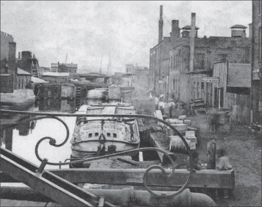
Boats entering the canal at Cleveland locked through Lock 44 before entering Merwin’s Basin, pictured above with Lock 43 in the background. Locks 43 and 44 were called sloop locks, since both were larger than the normal 90-foot-by-15-foot canal locks. This allowed for the passage of lake traffic above (south of) Lock 43, where the canal was lined with dry docks and warehouses. The only weigh lock on the canal was located along this stretch near Seneca Street (now West Third Street). The below photograph, showing the canal farther south, looks from Ontario Street toward the Industrial Flats. (Above, courtesy of Dave Meyer; below, CSO.)
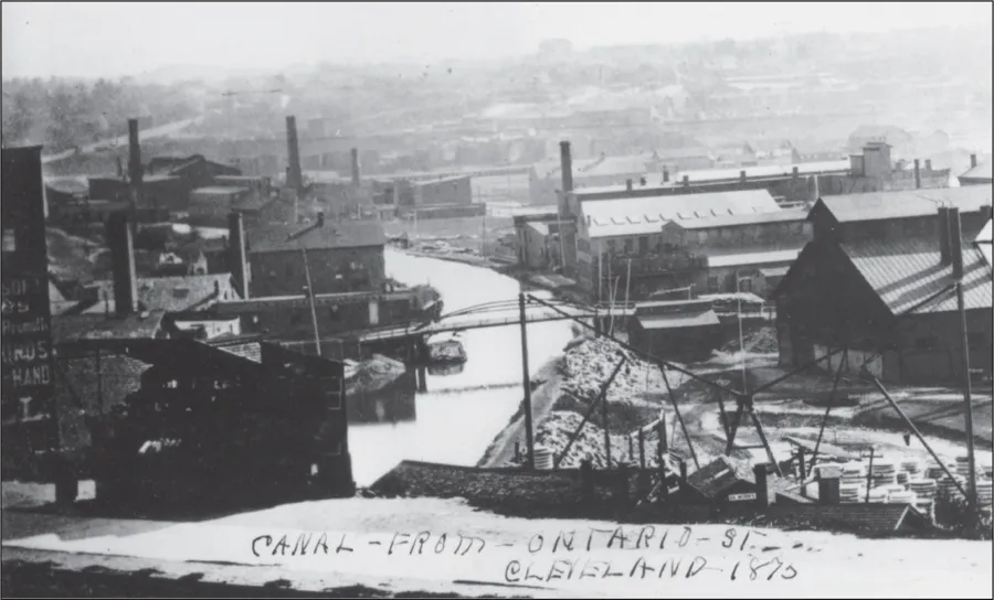

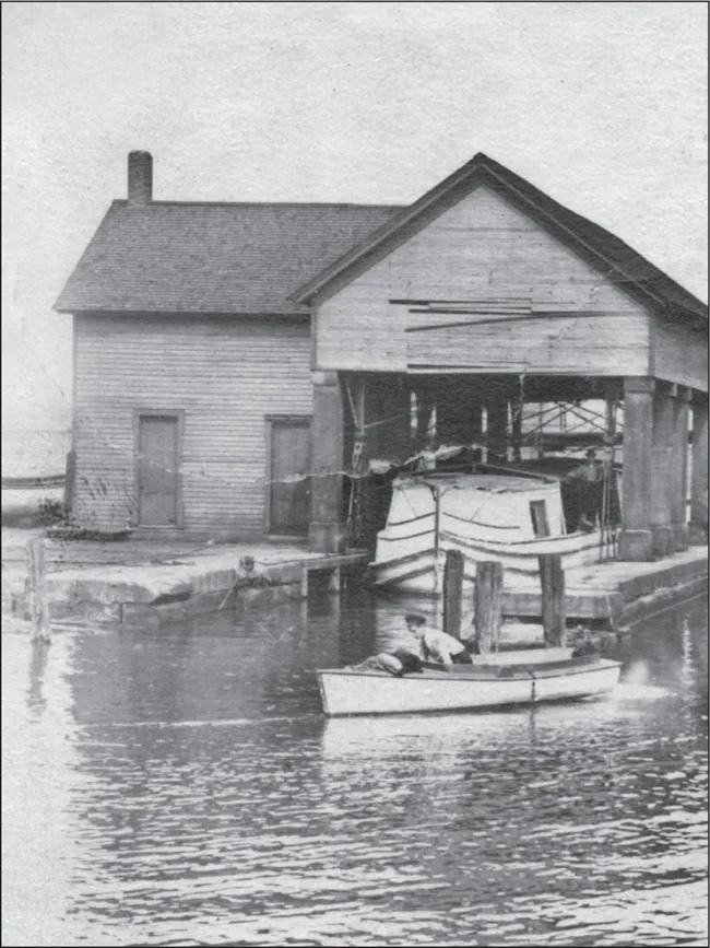
The area shown above became the northern terminus of the Ohio and Erie Canal after 1878. The canal originally extended into downtown Cleveland, but the Valley Railway leased the right-ofway and laid tracks in the filled canal bed. The canal outlet was relocated along Independence Road near the foot of Dille Street, which required a new outlet lock into the Cuyahoga River. This lock, Lock 42, is seen on the left. The river is in the background, and the Grasselli Chemical Company is at center. A stub of the old canal, called the Dog Pond, is at right. Dredges, like the one shown below at the relocated terminus, were essential for keeping the canal clear for navigation. (Above, CSO; below, courtesy of Bill Oeters.)


Moving the canal terminus also required moving the weigh lock, shown in these photographs. It was located just above the post-1878 terminus at Lock 42. Boats entered the lock chamber and water was emptied, leaving the boat to rest on a cradle counterbalanced by iron weights. Once the scale was balanced, weight could be determined. Boats were weighed empty to measure a tare weight, which was then subtracted from the weight of a fully loaded boat. In this way, the amount of cargo being carried was determined for toll-collection purposes. (Above, UA-Baus; right, CSO.)

Shown above is a May 30, 1903, outing of the Young People’s Society of Christian Endeavor of Bethlehem Church. The group was listed as an “English and Bohemian” congregation in the 1903 Cleveland City Directory. An author of the period relayed a story about how the “Czechs took picnic lunches and walked to the old canal lock.” The identity of the lock being described is not known, nor is the lock shown here. The same author wrote about bands joining in on the fun, and that an “enthusiastic drummer once hit his head so hard that he fell overboard.” According to the ticket shown below, the ride cost a quarter and turned around at Lock 37. (Both, CSO.)


State boats and their work crews were critical for maintenance along the canal. Their responsibilities included repairing holes and leaks (burrowing animals were a particularly vexing problem), clearing debris, removing sediment, mowing canal grass, and maintaining locks, aqueducts, floodgates, and waste weirs. (UA-Baus.)

Both of these boys look qualified to be a hoggee. Hoggees along the towpath drove ...
Table of contents
- Cover Page
- Title Page
- Copyright Page
- Dedication
- Table of Contents
- Acknowledgments
- Introduction
- 1. Cuyahoga Valley
- 2. Cascade Locks and Portage Summit
- 3. Upper Tuscarawas Valley
- 4. Lower Tuscarawas and Muskingum Valleys
- 5. Licking Valley and Summit
- 6. Little Walnut and Upper Scioto Valleys
- 7. Lower Scioto Valley
- Bibliography
Frequently asked questions
Yes, you can cancel anytime from the Subscription tab in your account settings on the Perlego website. Your subscription will stay active until the end of your current billing period. Learn how to cancel your subscription
No, books cannot be downloaded as external files, such as PDFs, for use outside of Perlego. However, you can download books within the Perlego app for offline reading on mobile or tablet. Learn how to download books offline
Perlego offers two plans: Essential and Complete
- Essential is ideal for learners and professionals who enjoy exploring a wide range of subjects. Access the Essential Library with 800,000+ trusted titles and best-sellers across business, personal growth, and the humanities. Includes unlimited reading time and Standard Read Aloud voice.
- Complete: Perfect for advanced learners and researchers needing full, unrestricted access. Unlock 1.5M+ books across hundreds of subjects, including academic and specialized titles. The Complete Plan also includes advanced features like Premium Read Aloud and Research Assistant.
We are an online textbook subscription service, where you can get access to an entire online library for less than the price of a single book per month. With over 1.5 million books across 990+ topics, we’ve got you covered! Learn about our mission
Look out for the read-aloud symbol on your next book to see if you can listen to it. The read-aloud tool reads text aloud for you, highlighting the text as it is being read. You can pause it, speed it up and slow it down. Learn more about Read Aloud
Yes! You can use the Perlego app on both iOS and Android devices to read anytime, anywhere — even offline. Perfect for commutes or when you’re on the go.
Please note we cannot support devices running on iOS 13 and Android 7 or earlier. Learn more about using the app
Please note we cannot support devices running on iOS 13 and Android 7 or earlier. Learn more about using the app
Yes, you can access Ohio and Erie Canal by Boone Triplett in PDF and/or ePUB format, as well as other popular books in History & North American History. We have over 1.5 million books available in our catalogue for you to explore.