- 30 pages
- English
- ePUB (mobile friendly)
- Available on iOS & Android
eBook - ePub
Burma Campaigns: Battles Over Lines Of Communication
About this book
On 19 January 1942, two Japanese divisions invaded Burma and within five months defeated a numerically superior Allied Army. The Japanese conquest of Burma completely isolated China from lend-lease equipment support provided to it via the Burma Road. Over the course of the next three years, Allied forces engaged in ground campaigns designed to re-establish this land communications link with China. This is a description of the Allied campaigns in Burma and the importance that secure supply lines played in each of those campaigns. Information was gathered by historical review of a variety of reference materials. The lessons of Burma related to the campaigns launched there can be applied today in that country and in similar areas of operation around the world.
Trusted by 375,005 students
Access to over 1.5 million titles for a fair monthly price.
Study more efficiently using our study tools.
Information
Subtopic
Military & Maritime HistoryIndex
HistoryBACKGROUND
Strategically, the Japanese conquest of Burma was part of a much larger plan that involved the isolation of the Chinese forces fighting against them in China. This isolation was designed to prohibit the flow of lend-lease material to China from the outside world, primarily the United States.{5}
To accomplish this, the Japanese had occupied all of the east coast of China as well as Indochina and Thailand prior to their attack at Pearl Harbor. Similarly, supplies entering China from the North had been stopped when the Germans attacked Russia. With the conquest of Burma, the Japanese had completed their isolation of China from the outside world.{6}
Burma was also significant to the Japanese on a much larger scale. It provided the linchpin for the Japanese defensive line that extended from eastern China through Indochina and Burma down the Malayan Peninsula, through the East Indies and on out into the Pacific Ocean.{7}
The British viewed the defense of Burma as secondary to that of India's. The German aggression in Europe, North Africa and especially the Middle East led the British to believe instead, that an attack through Afghanistan into India was the most likely scenario. Likewise, the British felt that a Japanese attack on Burma from Thailand was virtually impossible due to the lack of east-west roads and the rugged terrain along that border.{8}
Consequently, Burma was considered to be a natural buffer between India and the invading Japanese Army making its way through Indochina. Resources that could have been used for the defense of Burma were therefore shifted to the defense of India. Improvements were made to the road and rail networks along the Afghanistan-Indian border. This was done at the expense of improvements to Burma's border with India.{9}
Although roads and railways existed in northeastern India, they were primitive and primarily used by the tea and jute industry to transport crops to Calcutta. Moving military supplies and units over them in support of the British Army would be slow and very difficult. For example, the railway system was broad-gauged track and ran from Calcutta 235 miles north to Parbatipur. For half this distance only a single track existed. At Parbatipur coolies unloaded the trains and transferred their cargo to another train that ran on the meter-gauged track 220 miles up the Brahmaputra Valley to the ferry at Pandu. Here the railcars were pushed onto the ferry and were transported across the Brahmaputra River where the ferry was unloaded of the railcars and train. Reassembled on the other side, the train continued its trip one hundred miles to Dimapur where it was again unloaded and its cargo moved over land to the waiting British forces now defending the India-Burma border.{10}
The Japanese conquest of Burma then, not only isolated China, but placed the defense of India and the support of the retreating British Army at risk. This was the precarious position in which the British Army found itself in May 1942. Over the course of the next three years, the British and Japanese would engage in battle in tropical jungle and hills and employ air power on an unprecedented scale. Each would come to understand the importance of secure lines of communication.
BURMA
Burma was a British colony of approximately sixteen million people at the onset of World War II (FIG. 1). It was almost 1200 miles long and 575 miles wide and had a total area of 263,000 square miles or about the size of France. Cities, towns and villages were concentrated along the rivers and coast, with Rangoon, the capital and largest city located at the mouth of the Irrawaddy River on the Bay of Bengal. About 500 miles north was the town of Mandalay, a major center for the transportation of goods south to Rangoon.{11}
Natural barriers limited access to Burma except by sea. The Himalayan Mountains in the North prohibited entry into Burma from that direction. In the East, the Shan Hills with peaks up to 7500 feet ran parallel to the Burma-Thailand border. The 10,000 foot Naga and Chin Hills in the West ran north to south along the India-Burma frontier. These two mountain ranges were passable by foot only. Likewise, the mountains, rivers and climate within Burma were obstacles to military operations. Because of the north-south orientation of these mountains, military forces operating in Burma had to overcome terrain difficulties when moving east to west.{12}
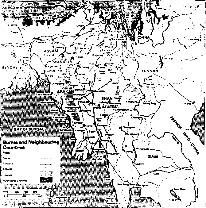
FIG. 1 — Source: E.D. Smith. Battle for Burma. Holmes & Meier Publisher, Inc., p. 19.
The rivers, chief among them the Chidwin in the northwest, the Salween in the East and the Irrawaddy and Sittang in central Burma followed north-south courses. All rivers flooded their banks during the wet monsoon season which lasted from June to October. As a result, low-lying areas became impassable swamps in much of the country. The major rivers were navigable in the rainy season and travel on them by small boats and barges was possible.{13}
The main roads and railway lines in Burma followed the line of the rivers and therefore were primarily oriented north-south as well. There were no roads into the country from India and Thailand suitable for the movement of men, equipment and supplies. Roads, or more accurately trails, were absent in the interior of the country. Except for a road that ran south and east down the Kabaw Valley and Chin Hills to the town of Kalewa on the Chidwin River, east-west movement anywhere else in Burma had to be made by foot or pack animals over jungle trails.{14}
Climate and disease were important considerations when conducting military operations in Burma. Heavy rains fell over the country during the rainy season. Average annual rainfalls ranged from 71 inches in the North to 188 inches in the South. The coastal areas of the Bay of Bengal received heavier rainfall with the Arakan Yoma in southwestern Burma averaging about 200 inches. Diseases were as serious an obstacle as the climate and terrain. Malaria, typhus and dysentery were the most common health hazards experienced.{15}
ALLIED STRATEGY
Allied strategy in the China, Burma, India (CBI) theater was based on keeping China in the war against Japan, thereby containing large Japanese forces that might be used elsewhere in the Pacific. Similarly, American planners hoped that Chinese air bases could eventually be used for the bombardment of Japan. They also hoped that the large Chinese manpower pool could be trained, equipped and used in a final offensive to bring about the defeat of the Japanese Army.{16}
This entire strategy was based on the availability of the Burma Road for transportation of lend-lease equipment to China. With the completion of the Japanese conquest of Burma, all plans based on the Burma Road were rendered obsolete.{17}
Allied planners therefore began to devise strategies that would keep China in the war and drive the Japanese from Burma. To accomplish this, Chinese and British leaders argued for an amphibious assault to recapture Rangoon, while the Americans insisted that the best way to keep China in the war and Japanese forces committed to fighting in Burma was to conduct a ground campaign in northern Burma.{18}
Eventually plans were developed for a series of amphibious assault along the coast of Burma. The liberation of Rangoon was the final objective. Simultaneously, Allied plans envisioned a land campaign into Burma from three directions. The American-led Chinese would attack in north Burma supported by a Chinese attack across the Salween down the Burma Road and a link-up in the vicinity of Mandalay. The British on the other hand, were to attack from Imphal in eastern India and eventually join with the Chinese as they drove south to capture Rangoon. The idea of a major offensive on this scale was abandoned because of a lack of amphibious shipping, an inadequate logistics base and insufficiently trained ground forces.{19}
Realizing these shortcomings, American and British commanders in the autumn of 1942 agreed to split the responsibility for the re-conquest of Burma. The British would have responsibility for the Imphal and Arakan fronts while the Americans accepted responsibility for the northern front. This included the construction of a road from Ledo on the Indian frontier through Myitkyina in north-central Burma. The Ledo road as it was known, was to join the Burma Roaj near Wanting on the China-Burma border.{20}
In the China, Burma, India theater, Allied and Japanese campaign planning was decentralized at Army or Corps level. Campaign approval, on the other hand, was centralized at theater or national levels due mainly to resource considerations for operations in other theaters and operational areas. Generally, planners envisioned campaigns on a larger and more ambitious scale than those that were actually executed. The major limiting factors were terrain, adequate forces, logistics and the harsh environment in which the each campaign was fought.
The remainder of this paper will describe the campaigns fought in Burma by Allied and Japanese forces (FIG. 2). Where possible, this paper will follow this chronological sequence. It should be noted that some campaigns were fought simultaneously, even though they were independent operations.
Figure 2 — Major Campaigns and Operations in Burma
Japanese Conquest of Burma—January-May 1942
First Arakan Campaign —December 1942-May 1943
First Wingate Expedition—February-April 1943
(Operation Longcloth)
Second Arakan and 'HA-GO'—January-March 1944
Campaigns
North Burma Campaign — October 1943-March 1945
Second Wingate Expedition — March-August 1944
Japanese 'U-GO' Campaign — March-May 1944
Allied Re-Conquest of Burma — June 1944-April 1945
THE FIRST ARAKAN CAMPAIGN
Long before the Allied retreat of 1942 was over, General Archibald Wavell, the Commander-in-Chief of British forces in India, had begun planning a counterattack for the fall dry season. The British desperately need a victory to bolster their morale and gain confidence in their ability to fight the Japanese. A lack of amphibious ships and adequate forces prevented him from engaging the Japanese on the scale outlined in the Allied strategy. Instead he settled for a ground campaign in the Arakan Yoma, down the Mayu Peninsula to the island and town of Akyab. He felt that the use of the airfield at Akyab could provide air cover for a land campaign into central Burma or for an amphibious assault on Rangoon.{21}
The British offensive in the Arakan began in December 1942. Two British-led Indian divisions attacked down the rugged Mayu Peninsula and initially met with little resistance. Only two Japanese battalions defended Akyab and a swift advance on the part of the Allies would have ...
Table of contents
- Title page
- TABLE OF CONTENTS
- ABSTRACT
- INTRODUCTION
- BACKGROUND
- REQUEST FROM THE PUBLISHER
- BIBLIOGRAPHY
Frequently asked questions
Yes, you can cancel anytime from the Subscription tab in your account settings on the Perlego website. Your subscription will stay active until the end of your current billing period. Learn how to cancel your subscription
No, books cannot be downloaded as external files, such as PDFs, for use outside of Perlego. However, you can download books within the Perlego app for offline reading on mobile or tablet. Learn how to download books offline
Perlego offers two plans: Essential and Complete
- Essential is ideal for learners and professionals who enjoy exploring a wide range of subjects. Access the Essential Library with 800,000+ trusted titles and best-sellers across business, personal growth, and the humanities. Includes unlimited reading time and Standard Read Aloud voice.
- Complete: Perfect for advanced learners and researchers needing full, unrestricted access. Unlock 1.5M+ books across hundreds of subjects, including academic and specialized titles. The Complete Plan also includes advanced features like Premium Read Aloud and Research Assistant.
We are an online textbook subscription service, where you can get access to an entire online library for less than the price of a single book per month. With over 1.5 million books across 990+ topics, we’ve got you covered! Learn about our mission
Look out for the read-aloud symbol on your next book to see if you can listen to it. The read-aloud tool reads text aloud for you, highlighting the text as it is being read. You can pause it, speed it up and slow it down. Learn more about Read Aloud
Yes! You can use the Perlego app on both iOS and Android devices to read anytime, anywhere — even offline. Perfect for commutes or when you’re on the go.
Please note we cannot support devices running on iOS 13 and Android 7 or earlier. Learn more about using the app
Please note we cannot support devices running on iOS 13 and Android 7 or earlier. Learn more about using the app
Yes, you can access Burma Campaigns: Battles Over Lines Of Communication by Lieutenant Colonel Kurt M. Frey in PDF and/or ePUB format, as well as other popular books in History & Military & Maritime History. We have over 1.5 million books available in our catalogue for you to explore.